 PDF(3962 KB)

甘肃省县域乡村振兴与新型城镇化耦合协调发展的时空分异特征及影响因素
尹君锋, 石培基, 黄万状, 石志浩, 李雅丽
自然资源学报 ›› 2023, Vol. 38 ›› Issue (8) : 2148-2168.
PDF(3962 KB)
PDF(3962 KB)
甘肃省县域乡村振兴与新型城镇化耦合协调发展的时空分异特征及影响因素
Spatiotemporal differentiation characteristics and influencing factors of coupling coordinated development of rural revitalization and new urbanization at the county level in Gansu province
 ({{custom_author.role_en}}), {{javascript:window.custom_author_en_index++;}}
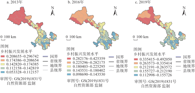
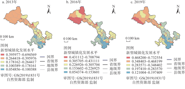
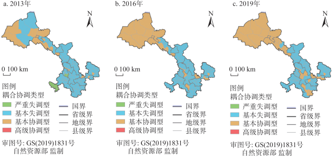
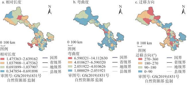
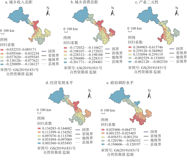
基于城乡统筹发展与区域协同发展研究视角,通过构建乡村振兴与新型城镇化综合评价指标体系,运用耦合协调度模型、LISA时间路径、LISA时空跃迁及地理加权回归模型等方法,分析2013—2019年甘肃省86个县域单元两者间耦合协调发展水平、时空分异特征及影响因素。结果表明:(1)全省县域乡村振兴与新型城镇化发展水平在空间分布上具有相似性,均呈现“西北高、东南低”的发展态势。其中,河西地区乡村振兴与新型城镇化发展水平最高。河西地区乡村振兴与新型城镇化耦合协调度处于全省首位,陇中地区与陇东南地区耦合协调度相对较低。全省各县域在基本失调类型和基本协调类型中乡村振兴发展滞后型均占大多数,不存在新型城镇化发展滞后型。(2)县域耦合协调度空间格局具有一定的平稳性,在局部空间依赖方向和空间增长过程中具有波动性较弱特征,受周边邻近城市溢出效应或虹吸效应相对较弱。县域自身耦合协调度受相邻县域的溢出效应影响程度较小,整体呈现出的高增长或低增长趋势较为明显。耦合协调度的局部空间关联格局保持在一定的稳定态势,多数县域未发生跃迁,空间格局呈现出一定的转移惰性与路径依赖特征。(3)县域乡村振兴与新型城镇化耦合协调度影响因素在空间上差异较大,城乡收入差距、城乡消费差距、产业二元性水平不利于两者耦合协调度的提升,经济发展水平、政府调控水平对两者耦合协调度的提升具有促进作用。
Based on the research perspective of urban-rural integrated development and regional coordinated development, by constructing a comprehensive evaluation index system for rural revitalization and new urbanization, using the coupled coordination degree model, LISA time path, LISA spatiotemporal leap, and geographically weighted regression model, this paper analyzed the coupling coordinated development level, spatiotemporal differentiation characteristics and influencing factors of 86 county units in Gansu province from 2013 to 2019. The results show that: (1) During the study period, the spatial distribution of county-level rural revitalization and new urbanization is similar, showing a development pattern of "high in the northwest and low in the southeast". Among them, the development level of rural revitalization and new urbanization in the Hexi region is the highest. The coupling coordination of rural revitalization and new urbanization in the Hexi region is the highest, while the coupling coordination of the Central and Southeastern Gansu regions is relatively low. Among the basic imbalance types and basic coordination types, the rural revitalization development backward type accounts for the majority in all the county units of Gansu, and there is no new urbanization development backward type. (2) The spatial pattern of the coupling coordination degree at the county level has a certain degree of smoothness. It has weak volatility in the local spatial dependence direction and spatial growth process and is relatively weak by neighboring cities' spillover effect or siphon effect. The coupling coordination degree at the county level is less affected by the spillover effect of adjacent county units, and the overall trend of high or low growth is more prominent. The local spatial correlation pattern of the coupling coordination degree is kept in a stable situation, and most counties have not experienced any transition; the spatial pattern shows certain characteristics of transfer inertia and path dependence. (3) The influencing factors of the coupling coordination of rural revitalization and new urbanization at the county level are different in space. The urban-rural income gap, urban-rural consumption gap, and industrial duality are not conducive to improving the coupling coordination between the two. On the other hand, the level of economic development and government regulation can improve the coupling coordination between the two.
乡村振兴 / 新型城镇化 / 协调发展 / 驱动因素 / 甘肃省 {{custom_keyword}} /
rural revitalization / new urbanization / coordinated development / driving factor / Gansu province {{custom_keyword}} /
表1 县域乡村振兴与新型城镇化发展评价指标体系Table 1 Evaluation index system for county-level rural revitalization and new urbanization development |
| 目标层 | 准则层 | 指标层 | 指标解释 |
|---|---|---|---|
| 乡村振兴 | 产业振兴 | 集约化经营水平 | 农业土地产出率 |
| 机械化水平 | 农作物耕种收综合机械化率 | ||
| 机械处理保障水平 | 万人农田基本设施建设及畜牧养殖机械设备数 | ||
| 农机建设规模投入程度 | 单位耕地面积农业机械总动力 | ||
| 人才振兴 | 现代服务业从业情况 | 从事现代服务业人员占比 | |
| 农业专业人才发展情况 | 农民专业化从业人员占农林渔牧业从业人员比例 | ||
| 乡村人口受教育情况 | 乡村高中及以上学历人数比例 | ||
| 乡村经济管理人才情况 | 万人乡村经济管理人员 | ||
| 文化与组织振兴 | 文化设施支撑情况 | 村均图书馆及文化馆数量 | |
| 教育文化娱乐消费情况 | 乡村居民教育文化娱乐支出占比 | ||
| 组织专业化发展情况 | 万人农民专业合作社及农机专业合作社数量 | ||
| 组织服务化发展情况 | 万人农业技术服务机构数量 | ||
| 生态振兴 | 生活垃圾处理化水平 | 生活垃圾得到治理的村占比 | |
| 生态修复治理情况 | 荒山荒沙地造林及水土流失生态治理面积占比 | ||
| 耕地绿色发展情况 | 单位耕地面积化学肥料使用强度 | ||
| 新型城镇化 | 人口城镇化 | 人口数量结构 | 年末城镇人口占总人口比例 |
| 人口承载情况 | 建成区人口密度 | ||
| 人口就业吸纳情况 | 第二、三产业从业人员占总就业人员比例 | ||
| 经济城镇化 | 经济发展情况 | 人均GDP | |
| 产业结构优化情况 | 第二、三产业产值占GDP比例 | ||
| 经济运行状况 | 城镇社会消费品零售总额 | ||
| 社会城镇化 | 公用设施建设情况 | 人均城市道路面积 | |
| 居民生活水平情况 | 城镇居民人均可支配收入 | ||
| 公共服务设施情况 | 万人卫生医疗机构床位数 | ||
| 绿色城镇化 | 城市绿地建设情况 | 建成区绿化覆盖率 | |
| 城市绿化环境情况 | 人均公园绿地面积 | ||
| 城市整洁情况 | 生活垃圾无害化集中处理率 |
表2 乡村振兴与新型城镇化耦合协调类型划分Table 2 Classification of coupling coordination degree of rural revitalization and new urbanization |
| 类型 | 耦合协调度 | 亚类型 | U1与U2界定 |
|---|---|---|---|
| 高级协调 | 0.80<D≤1.00 | 高级协调—乡村振兴发展滞后 高级协调—新型城镇化发展滞后 高级协调 | U2-U1>0.1 U1-U2>0.1 0≤|U1-U2|≤0.1 |
| 基本协调 | 0.50<D≤0.80 | 基本协调—乡村振兴发展滞后 基本协调—新型城镇化发展滞后 基本协调 | U2-U1>0.1 U1-U2>0.1 0≤|U1-U2|≤0.1 |
| 基本失调 | 0.30<D≤0.50 | 基本失调—乡村振兴发展滞后 基本失调—新型城镇化发展滞后 基本失调 | U2-U1>0.1 U1-U2>0.1 0≤|U1-U2|≤0.1 |
| 严重失调 | 0<D≤0.30 | 严重失调—乡村振兴发展滞后 严重失调—新型城镇化发展滞后 严重失调 | U2-U1>0.1 U1-U2>0.1 0≤|U1-U2|≤0.1 |
表3 Local Moran's I散点图的转移概率矩阵Table 3 Transition probability matrix of Local Moran's I |
| t\t+1 | HH | LH | LL | HL |
|---|---|---|---|---|
| HH | Type 0(0.909) | Type I(0.023) | Type III(0.000) | Type II(0.068) |
| LH | Type I(0.138) | Type 0(0.828) | Type II(0.034) | Type III(0.000) |
| LL | Type III(0.014) | Type II(0.116) | Type 0(0.797) | Type I(0.073) |
| HL | Type II(0.125) | Type III(0.031) | Type I(0.063) | Type 0(0.781) |
表4 县域单元空间集聚演化类型Table 4 Evolution type of spatial agglomeration of county units |
| 演化状态 | 演化类型 | 县域单元 |
|---|---|---|
| 稳定型 | LL➝LL、HH➝HH、LH➝LH、HL➝HL | 白银区、靖远县、景泰县、秦州区、麦积区、清水县、凉州区、民勤县、古浪县、通渭县、西和县、徽县、两当县、临夏市、临夏县、康乐县、广河县、和政县、东乡县、积石山县、合作市、临潭县、玛曲县、碌曲县、夏河县、红古区、嘉峪关市、肃南县、民乐县、临泽县、高台县、山丹县、灵台县、崇信县、华亭市、肃州区、金塔县、瓜州县、肃北县、阿克塞县、玉门市、敦煌市、康县、永昌县、会宁县、天祝县、甘州区、崆峒区、合水县、镇原县、文县、礼县、永靖县、舟曲县、城关区、七里河区、西固区、皋兰县、金川区、平川区、甘谷县、庄浪县、渭源县、临洮县、武都区 |
| 极化➝均衡型 | HL➝LL、LH➝LL、HL➝HH、LH➝HH | 卓尼县、静宁县、西峰区、安定区、永登县、泾川县 |
| 均衡➝极化型 | LL➝HL、LL➝LH、HH➝HL、HH➝LH | 环县、漳县、岷县、成县、秦安县、武山县、张家川县、华池县、正宁县、宕昌县、榆中县、迭部县 |
| 同步均衡型 | LL➝HH | 陇西县、宁县、庆城县 |
| [1] |
叶超, 高洋. 新中国70年乡村发展与城镇化的政策演变及其态势. 经济地理, 2019, 39(10): 139-145.
[
{{custom_citation.content}}
{{custom_citation.annotation}}
|
| [2] |
卓玛草. 新时代乡村振兴与新型城镇化融合发展的理论依据与实现路径. 经济学家, 2019, (1): 104-112.
[
{{custom_citation.content}}
{{custom_citation.annotation}}
|
| [3] |
In the 69 years since the founding of the People’s Republic of China, especially the 40 years since the reform and opening-up, the relationship between urban and rural areas has undergone profound change. When the deepening reform of the urban-rural relationship is entering a critical period, it is necessary to reassess the evolution of the urban-rural relationship in China and draw a picture for that relationship in the future. The paper aims to discuss these issues.
{{custom_citation.content}}
{{custom_citation.annotation}}
|
| [4] |
徐维祥, 李露, 周建平, 等. 乡村振兴与新型城镇化耦合协调的动态演进及其驱动机制. 自然资源学报, 2020, 35(9): 2044-2062.
重构乡村振兴与新型城镇化的指标体系,采用耦合协调度模型、空间马尔可夫链以及地理加权回归模型,分析了2005—2017年中国30个省(市、自治区)乡村振兴与新型城镇化的耦合协调水平、时空分异格局、空间动态演进以及驱动机制。研究发现:(1)乡村振兴与新型城镇化的耦合协调度呈现“东部高、西南低”的分布特征,中级协调区域逐步向中部扩散,高级协调区域数量不断增加;高级协调类型省(市、自治区)中“乡村振兴滞后型”占大多数,初级协调和濒临失调类型省(市、自治区)中“新型城镇化发展滞后型”居多。(2)耦合协调度的动态演进呈现维持原有状态稳定性的特征,较难实现跨越式转移,处于高级协调阶段的省(市、自治区)存在“俱乐部趋同”现象。向上转移的省(市、自治区)主要集中在中部,向下调整的以北方省(市、自治区)居多;耦合协调较高的省(市、自治区)对邻近省(市、自治区)具有正向溢出效应,而耦合协调度低的省(市、自治区)对周围产生负向效应,且这种影响是不对称的。(3)影响乡村振兴与新型城镇化耦合协调度变化的驱动力空间差异显著,表现出层级带状分布的发展态势。政府驱动、投资驱动、人口驱动呈现南北层级带状分布。消费驱动、收入驱动、产业驱动呈现东西层级带状分布。
[
{{custom_citation.content}}
{{custom_citation.annotation}}
|
| [5] |
张英男, 龙花楼, 马历, 等. 城乡关系研究进展及其对乡村振兴的启示. 地理研究, 2019, 38(3): 578-594.
随着乡村振兴战略的实施,我国已经进入城乡关系变革及乡村发展快速转型的关键时期。科学认知国内外城乡关系理论发展和演变规律对实施乡村振兴战略、缩小城乡差距、调整城乡结构和优化城乡格局具有重要意义。本文在系统梳理国外城乡关系理论及我国乡村发展与城乡关系演进的阶段性特征的基础上,从经济、社会、生态及文化的视角阐述了我国乡村发展与城乡关系研究的相关进展,并在此基础上探讨了未来重点的研究领域和方向。乡村发展思维应由生产主义导向转向后生产主义,关注乡村多元价值,深化基于乡村多功能转型理论的乡村振兴机制、区域路径与模式研究;在科技迅速发展,新事物新因素大量涌现的新时代,应关注特色小镇、田园综合体、民宿及乡村电子商务等新兴乡村转型发展形态的形成机制;同时,基于不同地域类型的乡村振兴的机制与模式研究也应得到重视,结合国际乡村地理学前沿,深入开展发达地区乡村的混杂性研究。广泛的城乡空间重构进程对乡村地区产生剧烈的影响与挑战,对于乡村振兴视角下城乡空间重构的动力机制与模式的研究仍需持续关注;根据我国的特殊国情,创新适合我国基本国情与发展实际的乡村振兴理论与实现路径,推动城乡融合发展。
[
With the implementation of rural vitalization strategy, China has stepped into a critical period with the dramatic changes of urban-rural relations and the accelerating transformation development of rural territorial system. Scientifically understanding the research progress of urban-rural relation theory and evolution rule is of great significance for boosting rural vitalization, narrowing urban-rural disparity, adjusting urban-rural structure and optimizing urban-rural patterns. This paper elaborates the research progress of urban-rural relations and rural development in China from the dimensions of economy, society, ecology and culture based on the review of foreign urban-rural relations and the characteristics of domestic rural development, as well as the evolution of urban-rural relation. Furthermore, prospect of research focus or key fields in the future were given. Firstly, transforming the development idea from productivism oriented to post-productivism oriented and attaching importance to the multiple values of rural areas should be emphasized. Therefore, it is necessary to carry out intensive studies about the mechanism, regional path selection and development mode of rural vitalization based on the theory of rural multiple function transition. Understanding the relationship of different functions is essential for dealing with rural decline and realizing the comprehensive vitalization. Meanwhile, we should focus on the mechanism and format of rural vitalization based on different territorial types. Against the context of rural-urban integrated development, we should promote the supply-side reform and activate the forces of socio-economic growth in underdeveloped areas. As for the developed rural areas, the “hybridity” should be emphasized and further studies should be conducted. In some rural areas, the phenomenon of the hybridity of development agents, the combination of production space and living space, the mixture of rurality and modernism have emerged. Accordingly, more emphasis should be placed on the heterogeneity and diversity in the process of rural restructuring. Secondly, with the emergence of new factors or new technologies, we should focus on the new morphology of rural development, such as characteristic towns, rural complex and “Taobao village”. In recent years, China's rural areas have undergone intensive restructuring motivated by e-commerce, which has triggered a new wave of rural rejuvenation. But how e-commerce affects rural development and the characteristics of this process are still unclear, and this is important for understanding the urban-rural relations under the context of informatization. Thirdly, the mechanism and format of urban-rural spatial restructuring should be emphasized. From the perspective of urban-rural interaction, the theory of urban-rural network may be practical and meaningful for optimizing the spatial distribution of infrastructure construction and industrial development. Lastly, creating or improving the theory and improving the path of rural vitalization according to the national conditions are meaningful for realizing the strategy. {{custom_citation.content}}
{{custom_citation.annotation}}
|
| [6] |
尹君锋, 石培基, 张韦萍, 等. 乡村振兴背景下县域农业农村创新发展评价及空间格局: 以甘肃省为例. 自然资源学报, 2022, 37(2): 291-306.
实施农业农村现代化创新发展措施,将有效促使乡村振兴战略长远推进,形成我国农业农村创新发展的新局面。基于甘肃省86个县域研究单元,从创新投入、创新保障、创新效果三个维度构建了包含28个二级指标的农业农村创新发展评价指标体系,就农村地区创新发展水平进行综合评价。结果表明:(1)甘肃省农业农村整体创新发展得分呈上升趋势,但增长幅度较为缓慢。综合创新能力得分较高的县(区)主要集中在河西地区东部,得分较低的县(区)主要集中在南部民族地区。河西地区创新保障和创新效果水平处于全省前列,南部民族地区创新投入水平较低。(2)全省农业农村创新发展在东西方向上表现为西高东低,2013年以后逐渐表现出“两头高、中间低”趋势;在南北方向上表现北高南低;在东南—西北方向上呈现出西北高、东南低;在西南—东北方向上呈现出东北高、西南低。创新发展指数方向特征未发生明显变化,在空间上具有一定的锁定性。(3)创新发展热点区域集中在河西地区张掖市、武威市及金昌市,冷点区域集中分布在南部民族地区;极冷点区和极热点区数量减少,县域农业农村创新发展差距在减小。(4)多元资本投入、农业经济发展、自然地理条件及资源禀赋、农业基础设施配置、农业发展政策等通过内外因素结合创新发展供需两侧作用于甘肃省农业农村创新发展时空演化。
[
{{custom_citation.content}}
{{custom_citation.annotation}}
|
| [7] |
张许颖, 黄匡时. 以人为核心的新型城镇化的基本内涵、主要指标和政策框架. 中国人口·资源与环境, 2014, 24(s3): 280-283.
[
{{custom_citation.content}}
{{custom_citation.annotation}}
|
| [8] |
许彩玲, 李建建. 城乡融合发展的科学内涵与实现路径: 基于马克思主义城乡关系理论的思考. 经济学家, 2019, (1): 96-103.
[
{{custom_citation.content}}
{{custom_citation.annotation}}
|
| [9] |
刘威, 梅晶哲. 城乡融合发展: 西方理论局限与中国实践嵌入. 社会科学战线, 2022, (12): 220-232.
[
{{custom_citation.content}}
{{custom_citation.annotation}}
|
| [10] |
申晓艳, 丁疆辉. 国内外城乡统筹研究进展及其地理学视角. 地域研究与开发, 2013, 32(5): 6-12, 45.
[
{{custom_citation.content}}
{{custom_citation.annotation}}
|
| [11] |
邢溦, 王国勇. 贫困地区加快实现城乡融合发展的优化路径. 农村经济, 2019, (8): 51-59.
[
{{custom_citation.content}}
{{custom_citation.annotation}}
|
| [12] |
年猛. 中国城乡关系演变历程、融合障碍与支持政策. 经济学家, 2020, (8): 70-79.
[
{{custom_citation.content}}
{{custom_citation.annotation}}
|
| [13] |
何仁伟. 城乡融合与乡村振兴: 理论探讨、机理阐释与实现路径. 地理研究, 2018, 37(11): 2127-2140.
缩小城乡差距,促进城乡均衡发展,实现城乡居民生活质量等值,是乡村振兴和城乡融合发展的重要目标。通过基础理论的分析,探讨了城乡融合与乡村振兴科学内涵,剖析了城乡融合与乡村振兴的相互关系,构建了城乡空间均衡模型和定义城乡等值线,提出了中国城乡融合与乡村振兴实现途径及需要深入研究的方向。结果表明:① 城乡融合发展是基于空间布局优化和制度供给创新的经济、社会、环境全面融合发展,“乡村振兴五边形”和“人—地—钱—业”是乡村振兴的核心内涵;城乡融合与乡村振兴战略相互支撑,城乡融合和乡村振兴的过程是城乡空间动态均衡的过程。② 城乡发展的空间均衡模型可以较好地阐释促进城乡融合发展、实施乡村振兴的关键问题,通过城乡要素的重新优化配置和人口的流动,城乡人均综合发展效益逐渐趋于相等;城乡等值线可以进一步解释城乡发展空间均衡的动态过程与传导机理。③ 从政策制度构建、“点轴”渐进扩散、分区分类推进、典型发展模式提炼等方面探讨乡村振兴的科学路径,可以为中国乡村振兴战略实施提供理论参考。
[
Rural revitalization and urban-rural integration aim at narrowing the gap between urban and rural areas, promoting balanced development and realizing the equivalent life quality between urban and rural residents. Spatial equilibrium and its quantitative expression provide a new perspective to explain the pattern, process and mechanism of urban-rural integration and rural revitalization. Through the analysis of basic theory, this study discusses the scientific content and interaction between urban-rural integration and rural revitalization, sets up the urban-rural spatial equilibrium model, defines the urban-rural development isolines, works out the way to implement the urban-rural integration and rural revitalization in China, and addresses the potential for further research. The results show that: (1) Theory of regional system of man-land relationship and theory of spatial structure are the important theoretical basis for urban-rural integration and rural revitalization. The urban-rural integrated development depends on the all-round development of economy, society and environment with optimized spatial layout and innovative system, and rural revitalization mainly refers to the "pentagon of rural revitalization" and "people-land-capital-industry"; Urban-rural integration and rural revitalization strategy support each other, and the process of urban rural integration and rural revitalization is a dynamic equilibrium process between urban and rural areas. (2) The key issues of implementing rural revitalization and urban-rural integration can be illustrated through the urban-rural spatial equilibrium model, and the overall per capita benefits in rural areas gradually tend to be the same as that in cities by the re-optimization of urban-rural factors and population mobility; the dynamic process and mechanism of urban-rural integration spatial equilibrium is further interpreted via the urban-rural development isolines. (3) Exploring the implementation path of scientific rural revitalization strategy can achieve the goal of urban-rural integration and urban-rural spatial equilibrium development. The scientific path of rural revitalization is discussed from the perspectives of policy system construction, "pole-axis" spatial progressive diffusion, sub-area classification and typical development pattern, and it can provide theoretical reference for the strategy implementation of China's rural revitalization. {{custom_citation.content}}
{{custom_citation.annotation}}
|
| [14] |
刘彦随. 中国新时代城乡融合与乡村振兴. 地理学报, 2018, 73(4): 637-650.
城市与乡村是一个有机体,只有二者可持续发展,才能相互支撑。依据人地关系地域系统学说,城乡融合系统、乡村地域系统是全新认知和理解城乡关系的理论依据。针对日益严峻的“乡村病”问题,全面实施乡村振兴,既是推进城乡融合与乡村持续发展的重大战略,也是破解“三农”问题,决胜全面建成小康社会的必然要求。本文探讨了新时代城乡融合与乡村振兴的基础理论,剖析了乡村发展面临的主要问题,提出了问题导向的中国城乡融合与乡村振兴科学途径及研究前沿领域。结果表明:① 城乡融合与乡村振兴的对象是一个乡村地域多体系统,包括城乡融合体、乡村综合体、村镇有机体、居业协同体,乡村振兴重在推进城乡融合系统优化重构,加快建设城乡基础网、乡村发展区、村镇空间场、乡村振兴极等所构成的多级目标体系。② 中国“三农”问题本质上是一个乡村地域系统可持续发展问题,当前乡村发展正面临主要农业生产要素高速非农化、农村社会主体过快老弱化、村庄建设用地日益空废化、农村水土环境严重污损化和乡村贫困片区深度贫困化等“五化”难题。③ 乡村是经济社会发展的重要基础,城乡融合与乡村振兴战略相辅相成,乡村振兴应致力于创建城乡融合体制机制,推进乡村极化发展,按照产业兴旺、生态宜居、乡风文明、治理有效、生活富裕的要求,构建乡村地域系统转型—重构—创新发展综合体系。④ 乡村振兴地理学研究应着眼于乡村地域系统的复杂性、综合性、动态性,探究以根治“乡村病”为导向的新型村镇建设方案、模式和科学途径,为实现新时代中国乡村振兴战略提供理论参考。
[
Cities and villages are components of a specific organism. Only the sustainable development of two parts can support the prosperous development as a whole. According to the theory of man-earth areal system, urban-rural integrated system and rural regional system are the theoretical bases for entirely recognizing and understanding urban-rural relationship. To handle the increasingly severe problems of "rural disease" in rapid urbanization, accelerating rural revitalization in an all-round way is not only a major strategic plan for promoting the urban-rural integration and rural sustainable development, but also a necessary requirement for solving the issues related to agriculture, rural areas, and rural people in the new era and securing a decisive victory in building a moderately prosperous society in all respects. This study explores the basic theories of urban-rural integration and rural revitalization and analyzes the main problems and causes of rural development in the new era, proposing problem-oriented scientific approaches and frontier research fields of urban-rural integration and rural revitalization in China. Results show that the objects of urban-rural integration and rural revitalization is a regional multi-body system, which mainly includes urban-rural integration, rural complex, village-town organism, and housing-industry symbiosis. Rural revitalization focuses on promoting the reconstruction of urban-rural integration system and constructs a multi-level goal system including urban-rural infrastructure networks, zones of rural development, fields of village-town space and poles of rural revitalization. Currently, the rural development is facing the five problems: high-speed non-agricultural transformation of agriculture production factors, over-fast aging and weakening of rural subjects, increasingly hollowing and abandoning of rural construction land, severe fouling of rural soil and water environment and deep pauperization of rural poverty-stricken areas. The countryside is an important basis for the socioeconomic development in China, and the strategies of urban-rural integration and rural revitalization are complementary. The rural revitalization focuses on establishing the institutional mechanism for integrated urban-rural development and constructs the comprehensive development system of rural regional system, which includes transformation, reconstruction and innovation in accordance with the requirements of thriving businesses, pleasant living environments, social etiquette and civility, effective governance, and prosperity. Geographical research on rural revitalization should focus on the complexity and dynamics of rural regional system and explore new schemes, models and scientific approaches for the construction of villages and towns, which are guided by radical cure of "rural disease", implement the strategy of rural revitalization polarization, construct the evaluation index system and planning system of rural revitalization, thus providing advanced theoretical references for realizing the revitalization of China's rural areas in the new era. {{custom_citation.content}}
{{custom_citation.annotation}}
|
| [15] |
谢璐, 韩文龙. 数字技术和数字经济助力城乡融合发展的理论逻辑与实现路径. 农业经济问题, 2022, (11): 96-105.
[
{{custom_citation.content}}
{{custom_citation.annotation}}
|
| [16] |
刘春芳, 张志英. 从城乡一体化到城乡融合: 新型城乡关系的思考. 地理科学, 2018, 38(10): 1624-1633.
新型城镇化和乡村振兴战略的深入实施,推动城乡关系进入了一个融合发展的新阶段。采用Citespace1.0软件分析及文献归纳方法,识别了城乡关系研究热点,梳理了城乡关系研究在理论探索、影响因素、测度与评价、空间组织及推进策略等方面的研究进展。在此基础上,重点对面向城乡融合发展的新型城乡关系研究进行了总结,从理论基础与总体思路、多源数据与方法集成等方面提出了基于要素流动的城乡融合分析框架,指出了城乡融合研究的重点是基于多源数据的城乡关系测度与评价,城乡要素流动的特征、格局与效应,城乡要素融合发展的流动机制,城乡融合发展调控策略等。
[
The in-depth implementation of the new urbanization and rural revitalization strategy has pushed the urban-rural relationship into a new stage of integrated development. Based on Citespace1.0 software analysis and literature induction method, the paper identified the research hotspots of urban-rural relationship, reviewed the research progress of urban-rural relationship. Which included theoretical connotation and influencing factors of urban-rural relationship, measurement and evaluation of urban-rural connection, urban-rural spatial organization and development mode, and coordinated development of urban-rural areas and promotion strategy. Combining with the social economic background of information revolution and the change of urban-rural relationship in China, we points out that the construction of urban-rural relationship in the new period needs to change the traditional urban-rural relationship centered on the city, promote the integration of urban and rural areas and the formation of a new pattern of equal development between urban and rural areas. Based on this, we puts forward and discusses the construction and overall thought of a new urban-rural relationship toward urban-rural integration development. Then we proposes a framework for urban-rural integration analysis based on elements flow, puts forward the general idea of analyzing the characteristics, pattern and mechanism of urban-rural elements flow, which is supported by flow space theory and new mobility paradigm, multi-source data and visual analysis. The paper emphasizes the importance of measurement and evaluation of urban-rural relationship and the flow of urban-rural elements. The characteristics, pattern and mechanism of urban-rural factors flow, and the regulation and control strategy of the integration development of urban-rural areas are discussed in detail. The paper also explores the construction of the urban-rural integration database, the measurement of the flow of urban-rural elements and their spatial-temporal changes, and spatial simulation and visualization expression and other methods and techniques. {{custom_citation.content}}
{{custom_citation.annotation}}
|
| [17] |
张文斌, 张志斌, 董建红, 等. 迈向城乡共治:改革开放以来城乡关系演变解读. 地理科学进展, 2021, 40(5): 883-896.
城乡关系历来是经济社会发展的重要关系及党和政府关注的重大问题。为探究城乡关系及其治理逻辑,论文借助CiteSpace软件分析改革开放以来城乡关系的研究热点,结合时代背景解读城乡关系的演变历程,进而揭示城乡关系的脉络特征与治理变革的内在逻辑。研究表明:改革开放以来城乡关系的演变经历了4个阶段,形成了“城乡关系向好发展—城乡关系再度失衡—城乡关系调整完善—城乡关系一体化发展”的演变脉络;折射出“打破城乡分割”“偏向城市领域”“统筹城乡发展”“推进城乡一体化”的治理逻辑;十九大以来,城乡关系向着城乡融合的方向发展,迈向城乡共治是新时代城乡融合发展的内在要求与治理趋势。最后,文章从废除城乡二元体制、建立新的配套体制机制,打破学科界限、融合跨学科知识和实践交叉应用,新型城镇化和乡村振兴两大战略有机结合等方面对城乡融合发展与城乡共治进行了研究展望。
[
The relationship between urban and rural areas in China has been an important relationship for economic and social development and a major concern of the party and the government. In order to explore the relationship between urban and rural areas and its governance logic, the CiteSpace software was used to analyze the research hotspots of rural-urban relationship since the reform and opening up in the 1970s and to interpret its change based on the historical background, and then reveal the contextual characteristics of rural-urban relationship and the internal logic of governance reform. The research shows that since the reform and opening up, rural-urban relationship has gone through four stages—from an improving urban-rural relationship, to rural-urban re-separation, rural-urban relationship adjustment, and integrated rural-urban development. The process reflects the governance logic of breaking the rural-urban division, favoring the urban field, balancing rural-urban development, and promoting rural-urban integration. Since the 19th National Congress of the Communist Party of China, the relationship between urban and rural areas has developed in the direction of rural-urban integration. Rural-urban co-governance is the internal demand and governance trend of integrated rural-urban development in the new era. Finally, the article discussed the prospect of integrated rural-urban development and rural-urban co-governance from the aspects of abolishing the rural-urban dual system and establishing new supporting systems and mechanisms, breaking disciplinary boundaries and integrating interdisciplinary knowledge and cross-application of practice, and organically combining the two strategies of new urbanization and rural revitalization. {{custom_citation.content}}
{{custom_citation.annotation}}
|
| [18] |
黄禹铭. 东北三省城乡协调发展格局及影响因素. 地理科学, 2019, 39(8): 1302-1311.
以东北三省36个地区为研究对象,系统构建了城乡协调的指标体系,采用基尼系数、空间自相关和空间回归等方法探讨了2005年、2010年和2015年东北三省城乡协调的空间格局和影响机制。研究表明:① 东北三省城乡协调度的区域差异不断扩大且具有明显的空间集聚特征,但集聚程度趋于减弱。② 不同地区城乡协调水平变化各异。研究期内,大连市和锦州市一直处于高水平城乡协调状态,朝阳市长期处于低水平城乡协调状态。鹤岗市和七台河市城乡协调度位次上升最明显,哈尔滨市和辽源市城乡协调度位次下降最显著。③ 从空间格局来看,中级城乡协调区增多且向北移动,初级城乡协调区减少且向中部集中,“南北高,中间低”的城乡协调格局基本形成。与此同时,城乡协调的冷热点均不断收缩,空间极化效应趋于减弱。④ 城镇化和农业规模化经营是促进东北城乡协调发展的主要力量,工业化并未显著促进东北城乡协调发展且与城乡协调发展负相关,农业现代化经营对城乡协调发展有正向作用,交通因素在近些年的促进作用逐渐凸显,经济发展水平与信息化水平对东北城乡协调发展的作用还不明显。
[
Coordinating urban-rural coordinated development is an important foundation for achieving economic sustainable development of region. This paper selects 36 prefecture-level units in Northeast China as samples and constructed systematic index system to evaluate the level of urban-rural coordinated development. Then, the paper uses Gini coefficient, spatial autocorrelation and spatial regression to research the spatial pattern and influence mechanism of urban-rural coordinated development in Northeast China in 2005, 2010 and 2015. The result shown that: 1) The regional difference of urban-rural coordination degree in Northeast China has shown an expanding trend, and the phenomenon of spatial agglomeration is obvious, but the intensity of spatial agglomeration is declining. 2) The level of urban-rural coordination varies diferent in different regions. During the study period, Dalian and Jinzhou have always been high level of urban-rural coordinated area, and Chaoyang has always been a low level of urban-rural coordinated area. Hegang and Qitaihe were the most obvious upward cities of urban-rural coordination order, while Harbin and Liaoyuan declined most significantly. 3) From the perspective of spatial pattern, intermediate urban-rural coordination areas increased and moved northward, while primary urban-rural coordination areas decreased and concentrated in the middle. Then, formed a "north-south high, middle low" urban-rural coordination pattern. At the same time, the cold and hot spots of urban-rural coordination are shrinking, and the spatial polarization effect tends to weaken. 4) Urbanization and large-scale agricultural management have a positive effect on urban-rural coordinated development, industrialization does not significantly promote the urban-rural coordination in northeast China and is negatively related to the urban-rural coordination, agricultural modernization plays a positive role in the urban-rural coordinated development. In recent years, transportation gradually plays an positive role in urban-rural coordinated development. Economic development level and informatization level in the urban-rural coordinated development in northeast China are not obvious. {{custom_citation.content}}
{{custom_citation.annotation}}
|
| [19] |
Uneven urban and rural development is one of the main reasons for the decline of the countryside. This imbalance could be measured by the urban-rural difference index (URDI). Existing studies on urban-rural differences have focused on single dimension between urban and rural areas, and lack a systematic multi-dimensional measurement. Based on the construction of an index system and model for measuring urban-rural differences, this study took the Huang-Huai-Hai Plain (HHHP) as the study area, explores the spatial pattern of urban-rural differences in the area, and used geographical weighted regression models to identify the factors affecting urban-rural development differences. Results show that the mean value of URDI in the HHHP was 0.295, and the URDI in its western region was higher than that in the east. The average URDI was relatively high in the western counties along the Beijing-Guangzhou Railway. The low level of urban-rural “population-land-industry” development in the HHHP is an important reason for the small differences between urban and rural areas. Improvements in road transportation infrastructure have led to an increase in the urban-rural development gap. However, the driving force of the road network on urban development is greater than that on rural areas. The role of county economic agglomeration is gaining strength. In the process of rapid economic development, more attention should be paid to the development of the rural economy and the overall revitalization of the countryside. The equivalent allocation of social service facilities is an effective way to solve the problem of urban-rural imbalance. Further analysis demonstrated that terrain factors have relatively little influence on the URDI. This study provides a new perspective and measurement method for understanding the integration of urban and rural development, and provides a useful reference for guiding the urban-rural integration development and the rural revitalization. {{custom_citation.content}}
{{custom_citation.annotation}}
|
| [20] |
蒋正云, 胡艳. 中部地区新型城镇化与农业现代化耦合协调机制及优化路径. 自然资源学报, 2021, 36(3): 702-721.
基于城乡统筹和区域协调发展的视角,构建了新型城镇化与农业现代化耦合协调发展评价指标体系,采用全局主成分分析、耦合协调度模型对2007—2017年中部地区两化的耦合协调机制及时空演化特征进行了系统研究。结果表明:(1)研究期间各省份新型城镇化与农业现代化以一定幅度的波动持续增长,但双向交互下的综合效益总体偏低,经济发展是驱动二者水平提升的主要动力;(2)中部地区新型城镇化与农业现代化表现为高度的耦合相关,2007—2017年两系统经历了“轻度失调—初级协调”的转变,耦合协调关系总体趋于不断优化,协调水平在空间格局上呈现“南高北低”的分异特征;(3)中部地区新型城镇化与农业现代化的耦合协调存在一定短板,相比之下新型城镇化的发展稍显滞后。2012年以来,在宏观政策的调控和引导下两系统发展的不平衡趋势逐步减弱,多数省份已先后实现不同协调等级的同步发展。掌握新型城镇化与农业现代化的耦合协调特征和时空演化趋势,对新时期中部地区崛起和现代化建设目标的实现有着积极的现实意义。
[
{{custom_citation.content}}
{{custom_citation.annotation}}
|
| [21] |
李二玲, 崔之珍. 中国区域创新能力与经济发展水平的耦合协调分析. 地理科学, 2018, 38(9): 1412-1421.
采用协整检验和耦合协调模型方法,分析不同尺度区域创新能力与经济发展水平耦合协调状况的时空演化及差异规律。结果表明:① 中国区域创新能力与经济发展水平具有长期稳定而短期跳跃性,区域创新并不必然带来经济发展。② 2005~2014年间,两者动态的耦合协调程度具有尺度敏感性且在地级尺度上偏低,但正逐步改善,区域差异随尺度的缩小而增大。③ 耦合协调高值区在省级层面分布在北京、上海、广东等沿海省份,地级层面分布除沿海城市外,还有内陆省会城市及其周边城市,分布由分散逐渐集聚,宏观上已经形成“沿海-腹地”型大创新-经济合作区。
[
The unidirectional driving relationship between regional innovation and economic development has attracted many scholars' attention, but their bidirectional coupling relationship has been neglected. By constructing the evaluation system of regional innovation capability and economic development level on the basis of their connotations, using the technologies of cointegration test and coupling coordination model, this paper analyzes the spatiotemporal evolution characteristics and the difference regularity of the coupling coordination between regional innovation capability and the economic development level on different spatial scales. It shows that: 1) In the long run, there is a stable cointegration relationship between China's regional innovation capability and economic development level, while salutatory relationship in the short-term. Regional innovation cannot necessarily bring about economic development. There is a higher degree of coupling coordination between economic development and innovation ability to the regions with a perfect regional innovation system, that is, with heterogeneous innovation actors, efficient innovation networks and innovation environment, and China's innovation-driven strategy could play a greater role. However, it is found that, during the period of 2005-2014, the degrees of coupling coordination between the two is scale-sensitive and it is generally low on the municipal scale, although increased progressively over time. It is imperative to upgrade the equilibrium relationship between the two from low to high; 2) The regional differences of the degree of coupling coordination between the two increased with the reduction of the spatial scale, however, the differences are decreasing; 3) The high-value areas of the coupling coordination at the provincial level are Beijing, Shanghai, Guangdong, Zhejiang and other South-East coastal areas in China with a scattered distribution. However, the high-value areas of the coupling coordination at the municipal level are more developed coastal cities, inland capital cities and their surrounding cities with a gathered distribution, preliminarily formed a national “coastal -hinterland” innovation-economic cooperation zone; 4) The key to China's innovation-driven strategy is to construct provincial and municipal innovation system, increase the innovation input, and promote the coupling docking and interaction feedback between the various links of government-industry-university-research cooperation. {{custom_citation.content}}
{{custom_citation.annotation}}
|
| [22] |
冯丹萌, 孙鸣凤. 国际视角下协调推进新型城镇化与乡村振兴的思考. 城市发展研究, 2020, 27(8): 29-36.
[
{{custom_citation.content}}
{{custom_citation.annotation}}
|
| [23] |
苏小庆, 王颂吉, 白永秀. 新型城镇化与乡村振兴联动: 现实背景、理论逻辑与实现路径. 天津社会科学, 2020, (3): 96-102.
[
{{custom_citation.content}}
{{custom_citation.annotation}}
|
| [24] |
徐雪, 王永瑜. 中国省域新型城镇化、乡村振兴与经济增长质量耦合协调发展及影响因素分析. 经济问题探索, 2021, (10): 13-26.
基于新型城镇化、 乡村振兴和经济增长质量的丰富内涵, 构建了新型城镇化—乡村振兴—经济增长质量耦合协调评价指标体系, 运用熵值法、 耦合协调度模型对 2011 - 2018 年中国 31 省区市新型城镇化 —乡村振兴—经济增长质量三系统综合发展水平及耦合协调度进行量化, 并结合面板 Tobit 模型对耦合协调度的影响因素进行研究。 结果表明: ①31 省区市新型城镇化—乡村振兴—经济增长质量三系统综合发展水平呈现显著的区域差异, 其中, 三系统综合水平都相对较高的省区市主要分布在东部地区, 而东北、 中部和西部地区三系统综合水平较低, 绝大多数低于全国平均水平。 ②全国三系统耦合协调度整体上偏低, 研究期内呈现缓慢上升并趋于稳定的发展趋势。 从空间演变来看, 耦合协调度具有显著的空间分异规律, 呈现 “东部> 中部 > 东北 > 西部” 的发展格局, 但耦合协调度的省际差异在逐步缩小, 均衡发展趋势有所显现。 ③在全国层面, 政府能力、 交通基础设施水平、 金融发展水平、 产业结构、 人口增长及劳动力质量对三系统耦合协调度具有显著的正向促进作用, 而城乡收入差距则不利于三系统的协调发展。 ④三系统耦合协调度的影响因素具有明显的区域异质性。
[
{{custom_citation.content}}
{{custom_citation.annotation}}
|
| [25] |
谭鑫, 杨怡, 韩镇宇, 等. 欠发达地区新型城镇化与乡村振兴战略协同水平的测度及影响因素: 基于政府效率和互联网发展视角. 经济问题探索, 2022, (11): 101-112.
[
{{custom_citation.content}}
{{custom_citation.annotation}}
|
| [26] |
徐雪, 王永瑜. 甘肃省新型城镇化与乡村振兴协调水平及其影响因素. 中国沙漠, 2022, 42(5): 1-13.
在新时代脱贫攻坚任务实现的背景下,提升新型城镇化与乡村振兴协调发展水平,有利于西北地区巩固拓展脱贫攻坚成果、持续增强内生发展动力并加快融入西部大开发新格局。鉴于此,运用改进的耦合协调度模型对2013—2018年甘肃省新型城镇化与乡村振兴的协调发展程度进行量化,并结合面板Tobit模型对二者耦合协调度的影响因素进行研究。结果表明:(1)新型城镇化与乡村振兴的空间分布基本一致,大体上呈现河西地区>陇中地区>陇东南地区>南部民族地区的空间发展格局。(2)全省、河西地区、陇中地区及南部民族地区新型城镇化与乡村振兴的协调发展效应逐步增强,耦合协调发展呈现西北强东南弱的空间分异特征,河西和陇中地区耦合协调水平明显高于陇东南及南部民族地区。(3)新型城镇化与乡村振兴同步发展类型的市州较少,乡村振兴滞后型的市州明显增加,并且集中分布于陇中地区及陇东南地区。(4)政府能力、工业化及交通基础设施水平对二者耦合协调水平具有正向促进作用,而固定资产投资和城乡收入差距则不利于新型城镇化与乡村振兴的协调发展。影响二者耦合协调度的因素具有明显的区域异质性。
[
In the context of the realization of the task of poverty alleviation in the new era, improving the coordinated development level of new urbanization and rural revitalization is conducive to consolidating and expanding the achievements of poverty alleviation in Northwest China, continuously enhancing the endogenous development power, and accelerating its integration into the new pattern of western development. In view of this, the improved coupling coordination degree model is used to quantify the coordinated development degree of new urbanization and rural revitalization in Gansu Province, and the influencing factors of their coupling coordination degree are studied combined with panel Tobit model. The results show that: (1) The spatial distribution of new urbanization and rural revitalization is basically the same, which generally presents the spatial development pattern of Hexi region > central Gansu region > southeast Gansu region > southern ethnic minority region. (2) During 2013-2018, the coordinated development effect of new urbanization and rural revitalization in the whole province, Hexi region, central Gansu region and southern ethnic areas has gradually increased. The coupling and coordinated development shows the spatial differentiation characteristics of strong northwest and weak southeast. The coupling and coordination level of Hexi and central Gansu region is significantly higher than that of southeast and southern ethnic areas. (3) There are fewer cities and prefectures with the synchronous development of new urbanization and rural revitalization, and the cities and prefectures with lagging rural revitalization have increased significantly, which are concentrated in central Gansu and southeast Gansu region. (4) Government capacity, industrialization and transportation infrastructure level play a positive role in promoting the coupling and coordination level of the two, while fixed asset investment and urban-rural income gap are not conducive to the coordinated development of new urbanization and rural revitalization. The factors affecting the coupling coordination degree of the two have obvious regional heterogeneity. {{custom_citation.content}}
{{custom_citation.annotation}}
|
| [27] |
吕萍, 余思琪. 我国新型城镇化与乡村振兴协调发展趋势研究. 经济纵横, 2021, (11): 76-82.
[
{{custom_citation.content}}
{{custom_citation.annotation}}
|
| [28] |
蔡继明. 乡村振兴战略应与新型城镇化同步推进. 人民论坛·学术前沿, 2018, (10): 76-79.
[
{{custom_citation.content}}
{{custom_citation.annotation}}
|
| [29] |
李刚, 李双元, 平建硕. 基于改进熵值TOPSIS灰色关联度模型的青海省乡村振兴评价及障碍因子分析. 中国农业资源与区划, 2021, 42(12): 115-123.
[
{{custom_citation.content}}
{{custom_citation.annotation}}
|
| [30] |
丁慧媛. 沿海地区新型城镇化综合发展水平测度. 统计与决策, 2019, 35(22): 50-53.
[
{{custom_citation.content}}
{{custom_citation.annotation}}
|
| [31] |
欧进锋, 许抄军, 刘雨骐. 基于“五大发展理念”的经济高质量发展水平测度: 广东省21个地级市的实证分析. 经济地理, 2020, 40(6): 77-86.
[
{{custom_citation.content}}
{{custom_citation.annotation}}
|
| [32] |
李琼, 赵阳, 李松林, 等. 中国社会保障与经济发展耦合的时空特征及驱动力分析. 地理研究, 2020, 39(6): 1401-1417.
利用耦合协调度模型、标准差椭圆、空间自相关等方法,研究2002—2017年中国社会保障与经济发展耦合协调的时空特征及驱动机制。结果表明:① 社会保障与经济发展之间相互适应、共同发展逐渐增强,但耦合协调度等级没有发生明显的跃迁,研究期内全国整体属于勉强耦合协调类范围,四大区域的耦合协调性呈东部地区>东北地区>中部地区>西部地区的态势。② 社会保障与经济发展的耦合协调度在东西和南北方向上收缩,向中部地区集聚的态势较明显;社会保障与经济发展的耦合协调整体上具有正的空间自相关性,局部空间自相关四种类型中,高高型集中分布在东部地区,低低型多在西部地区,高低型和低高型相对分散。③ 社会保障与经济发展的耦合协调在空间上的差异是内外部因素驱动的结果。内部驱动力中,城镇居民人均可支配收入、农村居民人均纯收入和人均GDP起到关键性作用;外部驱动力中,城镇化率和民营企业就业人数起了重要作用。
[
Entropy method, coupling coordination model, standard deviation ellipse model, spatial autocorrelation, etc., were used to measure the coupling coordination degree of social security and economic development in China from 2002-2017, and examine its spatio-temporal differentiation. At the same time, the influence degree and driving force were analyzed by grey correlation degree model and Pearson correlation coefficient. The results show that: (1) in terms of time series, the coupling coordination between social security and economic development in China is increasing, but lags behind the development of social security and the economy. The average annual coupling degree of the four major regions is Eastern region > Northeast region > Central region > Western region. (2) As for spatial aspects, the pattern of coupling and coordination between social security and economic development is solidified and dynamically changing, mainly due to the alternation of general maladjustment and forced coupling and coordination, and its spatial distribution has a tendency of aggregation. (3) In terms of driving force, five factors, namely, per capita disposable income of urban residents, per capita net income of rural residents, per capita GDP, urbanization rate and employment number of private economy, are the important driving forces of the coupling and coordination pattern of social security and economic development. {{custom_citation.content}}
{{custom_citation.annotation}}
|
| [33] |
毕斗斗, 王凯, 王龙杰, 等. 长三角城市群产业生态效率及其时空跃迁特征. 经济地理, 2018, 38(1): 166-173.
[
{{custom_citation.content}}
{{custom_citation.annotation}}
|
| [34] |
潘竟虎, 张永年. 中国能源碳足迹时空格局演化及脱钩效应. 地理学报, 2021, 76(1): 206-222.
利用DMSP-OLS夜间灯光数据和碳排放统计数据,构建碳排放面板数据模型,模拟了2000—2013年中国的碳排放量。运用探索性时空数据分析(ESTDA)框架体系,从时空交互视角分析2001—2013年碳足迹的空间格局和时空依赖动态演化;利用改进的Tapio脱钩模型对3个时间段336个地级单元环境碳负荷与经济增长之间的脱钩效应进行综合分析。研究表明:① 2000—2013年,中国的碳排放在时空演变上既表现出稳中有进的总体特征,也存在快速增长的阶段特征。② 碳足迹和碳赤字均呈逐年增长趋势,年均增长率分别为4.82%和5.72%;碳足迹和碳赤字整体北方大于南方,不同的行政单元尺度下碳足迹和碳赤字空间异质性特征明显。各地级单元碳足迹变异系数逐步增大,存在极为显著的空间自相关特征。③ LISA时间路径相对长度北方大于南方,且呈由沿海地区向中西部地区递增的趋势;LISA时间路径弯曲度整体上则由沿海地区向内陆地区递减。④ 综合脱钩指数整体以弱脱钩型为主,但弱脱钩型城市数量持续减少,扩张连接、扩张负脱钩区域数量逐渐增多且向中西部及东北地区聚集分布;全国平均脱钩弹性值逐步增长,变异系数持续下降。
[
The global environment issue resulting from carbon emissions has aroused worldwide concern for governments, the public and scientific communities. A precise measurement of the time-resolved and spatial distribution characteristics of carbon dioxide (CO2) and carbon footprint as well as its long-period evolution mechanism, can help clarify the relationship between environmental carbon load and economic growth, and are critical references to the formulation of scientific carbon emission reduction targets with reasonable and differential emission reduction policies. In this study, the mainland of China is taken as the research object. According to the quantitative correlations between DMSP-OLS nighttime light image data and carbon emission statistics, the carbon emission panel data model was simulated for China's carbon emissions in the period 2000-2013, and then the spatiotemporal evolving trend and spatial distribution characteristics of carbon emissions in the 14-year research period were discussed using Theil-Sen Median trend analysis and Mann-Kendall test method. Based on the framework of exploratory spatial-temporal data analysis (ESTDA), the spatial pattern and spatiotemporal dynamic evolution of carbon footprint from 2001 to 2013 were analyzed from the perspective of spatiotemporal interaction. In the three periods, the decoupling effect between environmental carbon load and economic growth of 336 prefecture-level cities were analyzed using the improved Tapio decoupling model. The results show that the overall carbon emissions in China had been on the rise from 2000 to 2013, in which the stable-slow rise type was dominant. China's carbon footprint and carbon deficit increased year by year, and the central and western regions became the focus of the growth of carbon footprint and carbon deficit from 2001 to 2013. At different administrative city scales, the spatial distribution pattern of carbon footprint and carbon deficit show obvious administrative orientated and spatial zonal differentiation characteristics. The annual average of global Moran's I index of each level unit is 0.491, which indicates that there is a significant spatial auto-correlation feature in the carbon footprint of China's prefecture-level units. The relative length of the LISA time path is greater in the north than in the south, and it tends to increase from the coastal areas to the central and western regions. The curvature of LISA time path decreases from coastal areas to inland areas on the whole. The curvature of northeast and central regions is higher, while that of eastern and western regions is lower. There is a different trend of the decoupling effect of environmental carbon load in China. Meanwhile the expansion-connection and expansion of negative decoupling regions continuously increased and spatially agglomerated, presenting an "E"-shaped distribution pattern from the north to the south. The national average decoupling elastic value is gradually increasing, while the coefficient of variation continues to decline, and the decoupling type has a significant evolution trend. Therefore, the unbalanced trend of economic growth and carbon emissions in China will continue for a certain period. {{custom_citation.content}}
{{custom_citation.annotation}}
|
| [35] |
{{custom_citation.content}}
{{custom_citation.annotation}}
|
| [36] |
{{custom_citation.content}}
{{custom_citation.annotation}}
|
| [37] |
{{custom_citation.content}}
{{custom_citation.annotation}}
|
| [38] |
宋伟轩, 毛宁, 陈培阳, 等. 基于住宅价格视角的居住分异耦合机制与时空特征: 以南京为例. 地理学报, 2017, 72(4): 589-602.
城市住宅价格空间分异,是居住空间资源非均衡配置的市场化表达,映射出不同阶层社会群体对城市住宅的选择倾向与需求差异,与居住空间分异在机制和格局上存在一定耦合关联。以南京主城区商品房社区为研究对象,构建起住宅价格特征变量指标体系,采用地理加权回归模型,分析导致房价空间差异的主要因素、组合关系及时空演变特征。研究发现:社区服务档次、学区资源、环境区位、景观稀缺等能够体现居住群体经济实力、生活方式与文化品位的因素,是影响房价分异的主导要素并随时间不断强化;南京房价总体上呈现“圈层+扇形+飞地”的空间结构,高房价主要分布在城市中心、名校学区、高档封闭社区和山水景观别墅区;房价分异与居住分异在作用机制和空间格局上表现出显著的关联耦合特征。城市房价空间分异不止于表达,同时也是推动居住空间分异与再分化的重要驱动机制,并能够预判未来一段时期内城市居住空间分异格局演变的基本走势,可以为城市社会空间研究提供具有前瞻性的观察视角和分析工具。
[
{{custom_citation.content}}
{{custom_citation.annotation}}
|
| [39] |
张前程, 龚刚. 政府干预、金融深化与行业投资配置效率. 经济学家, 2016, (2): 60-68.
[
{{custom_citation.content}}
{{custom_citation.annotation}}
|
| [40] |
童昀, 刘海猛, 马勇, 等. 中国旅游经济对城市绿色发展的影响及空间溢出效应. 地理学报, 2021, 76(10): 2504-2521.
在“生态优先、绿色发展”战略背景下,针对旅游经济绿色产业外部性及其空间溢出的科学认识缺乏,论证中国旅游经济能否促进绿色发展并揭示其空间溢出特征具有理论和现实意义。选取绿色全要素生产率(GTFP)作为城市绿色发展水平评价指标;融合多源数据并利用EBM-GML模型测算并分解中国284个地级以上城市2005—2016年GTFP;利用空间分析方法刻画地市尺度下GTFP时空格局及聚类情况;依托空间杜宾模型揭示旅游经济对绿色发展的影响及空间溢出效应。结果表明:① 东部、中部、西部、东北城市GTFP年度均值呈现总体上升态势,但“中部塌陷”特征明显;地市尺度中国GTFP格局与经济版图存在空间错位。② 旅游经济具有良好的绿色发展效应,能够同时促进绿色技术效率和绿色技术进步,进而驱动目的地本地GTFP增长。③ 旅游经济对GTFP存在不显著的正向空间溢出,但对绿色技术效率具有显著正向空间溢出。④ 政策上应加强区域内旅游经济联动发展,构建旅游目的地创新溢出机制,推动旅游目的地与邻地产业分工协同发展,打造旅游业深度参与的区域产业生态圈和综合体等,以期强化中国旅游经济对绿色技术进步的空间溢出。
[
Ecological priority and green development has become one of China's national strategies. Additionally, the scientific understanding of the green externality of tourism economy and its spatial spillover is still insufficient. Therefore, in terms of theoretical and practical significance, it is necessary to demonstrate whether China's tourism economy can promote green development and reveal its spatial spillover characteristics. On the basis of constructing the spatial spillover mechanism of green development effect of tourism economy, this paper selects green total factor productivity (GTFP) as the evaluation index of urban green development level based on bibliometric analysis; integrates multi-source data and uses EBM-GML model to calculate and decompose the GTFP of 284 cities at prefecture level in China from 2005 to 2016; uses the spatial analysis method to describe the spatio-temporal pattern and spatial clustering of GTFP at prefecture level. Based on the spatial Durbin model, this paper reveals the impact of tourism economy on green development and spatial spillover effect. The results show that: (1) the annual average of GTFP in eastern, central, western and northeastern China showed an overall upward trend. Eastern China has the largest improvement in GTFP (accumulated growth of 48.08%), followed by the western region (accumulated growth of 44.18%) and the northeastern region (accumulated growth of 36.05%), while the central region has the lowest improvement (accumulated growth of 26.56%), so that the "Central Collapse" feature is obvious. Moreover, there is a spatial dislocation between China's GTFP pattern and its economic map at the prefecture level. (2) The tourism economy could significantly promote the growth of local GTFP in tourist destinations by simultaneously promoting green efficiency change (GEC) and green technological change (GTC). (3) The spatial spillover mechanism of tourism economy on green development is reflected in the fact that tourism economy can significantly improve the GEC in neighboring cities, but it cannot significantly promote the GTC in neighboring cities. (4) In terms of policy, it is necessary to strengthen the linkage development of tourism economy within the region, and build an innovative spillover mechanism for tourism destinations. In addition, it is feasible to promote the coordinated development of tourism destinations and neighboring industries, and create a regional industrial ecosystem and complex with deep participation in the tourism industry. {{custom_citation.content}}
{{custom_citation.annotation}}
|
| {{custom_ref.label}} |
{{custom_citation.content}}
{{custom_citation.annotation}}
|


 PDF(3962 KB)
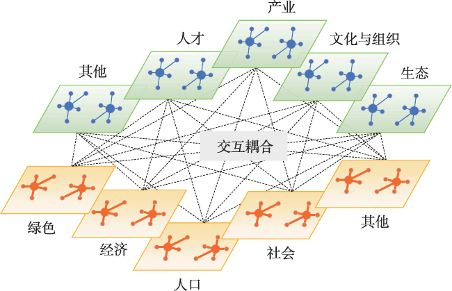
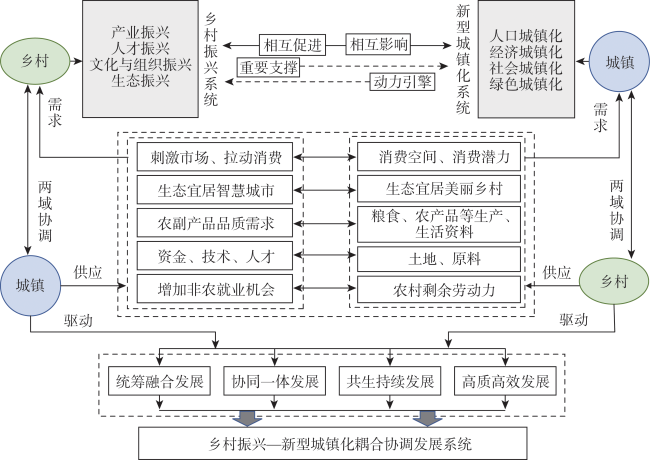
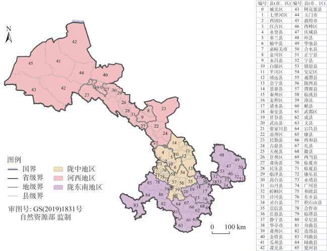
 图1 乡村振兴与新型城镇化多要素耦合发展图2 乡村振兴与新型城镇化耦合协调作用机理图3 研究区
 表1 县域乡村振兴与新型城镇化发展评价指标体系表2 乡村振兴与新型城镇化耦合协调类型划分图4 县域乡村振兴发展水平空间分异图5 县域新型城镇化发展水平空间分异图6 县域乡村振兴与新型城镇化耦合协调发展类型图7 LISA时间路径空间特征分布表3 Local Moran's I散点图的转移概率矩阵表4 县域单元空间集聚演化类型图8 县域乡村振兴与新型城镇化耦合协调度影响因素
/
| 〈 |
|
〉 |

 AI Summary

