

自然村落作为区域性的文化景观遗产,集中体现着聚落与周围自然环境相适应并持续演进的过程。其景观是生产性土地、水体、植被、聚落等构成的空间综合体[3],是内在文化的外在表现[4]。对乡村景观审美意象的解读[5]、景观资源的评价,以及景观产生、发展和消亡的演变分析[6],成为探讨乡村文化遗存、现状及未来保护方向的主要手段。文化地理视角的文化景观,核心是人与自然互动中空间挤压、融合的关系解读[7],映射着地方物质、精神和制度文化的相互渗透关系[8]。然而,注重客体价值的分析是已有文化景观研究的主要特点,虽然挖掘了承载村落文化价值的关键元素,但仍缺乏从人与自然互动视角对村落本体价值的广度认知。从文化地理视角对区域性景观的内在“溯源”与发展预测,成为从地理和历史延续性发掘其如何保护的关键。
景观内在格局、过程与特征的演变分析,建立了景观类型[8,9]、空间内涵[10]、功能性与动态性的相互联系[3],使人地关系嵌入空间描述全过程,成为探讨乡村景观演变中文化主体空间完整性保护的可拓展方向。反映格局与演变过程的“源汇”理论[11,12],从景观空间形态、景观格局、土地转移的规模化和目标多维性视角,揭示生态、人文景观变化的内部机制与未来变化方向[13],已被综合运用于城市生态治理和景观规划中[14]。已有研究明确提出“源汇”理论在传统乡村景观保护与导控中的可行性,探讨了理论应用在资源分类、评价和过程模拟中的生态与人文效益,系统性推导在文化景观网络系统构建中的正负双向“源汇”格局。但乡村文化对景观的依赖关系、景观与文化的相互映射,在“源汇”正负关系中仍未清晰界定[15],传统土地覆被、景观类型对文化的象征意义,在国土空间尺度上的分辨与指向性,缺乏宽泛样本的定性与实证[16]。自然与文化景观凝结空间的基本形态与功能[17,18],象征着文化圈层生态因子保护与遗产价值传承的目标导向,能否借鉴“源汇”理论识别景观本源中人与自然扩张、融合与平衡的关系[19],解析景观表达自然—文化轴线的身份和空间格局,借助区划手段探索景观分区特征,厘清区域整体景观的文化结构,仍有待从文化景观的动态演替视角,探索具有地理和历史延续性的乡村文化景观保护路径。
因此,本文立足景观“源汇”在探索景观物质能量流动和转化中的基础模式,围绕文化景观人与自然相互作用的基本特征,以黑龙江省宾县宾州镇为例,探索文化景观视域下将“源汇”嵌入文化景观进而拓展为景观“源—聚”的可行性,探讨遵循乡土景观本体价值和有机演进机制的文化活态保护路径,以期为乡村振兴下新型城镇化改造中的乡土文化统筹和发展定位提供可借鉴方案。
1 空间维度的景观“源—聚”理念架构
1.1 “源汇”理论与乡村景观保护
“源汇”分析是大气环境科学中分析物质流动、演变和转化过程的常用方法,其核心是通过“源”和“汇”将物质及景观起源和消亡的过程联系起来。近年来,“源汇”概念被引入景观格局和生态过程融合的研究中,“源汇”从景观能量的流动和转化规律建立“源”扩散的演变过程[13],成为判别和模拟景观演变、搭建系统性网络的关键。在景观的“源”“汇”解析中,“源”被定义为促进景观过程的空间,“汇”是“源”扩张中阻止或延缓景观过程的阻力因素。“源”和“汇”在空间运动中呈现相互挤压的互斥关系。在乡村地区,“源”和“汇”的博弈常常表现为聚落生活空间、传统农业生产空间、荒野生态空间之间的竞争和覆盖。通过“源汇”模拟的空间演变过程,不仅能够探讨乡村格局转移的过程,发掘其规律和乡村用地的适宜性区域,服务于不同景观类型的规划和保护;更能最大程度地从地理空间的深层次系统性保证乡村格局的完整性,形成以斑块、廊道为载体的景观连续性设计,为乡村景观的发展和保护搭建系统性网络。
1.2 文化景观视域下从“源汇”到景观“源—聚”
乡村文化景观是人与自然长期互动的“遗产”。美国地理学家索尔早在1927年就将景观定义为“附加在自然景观之上的各种人类活动形态”,揭示了景观在表现人与自然关系、表达文化和地域特征中的重要意义[20]。从时间维度景观演变的脉络和规律,能够折射人与自然互动延续的基础和动力[21]。在空间维度上,包括聚落、农田、山体、林地等景观要素的地理空间关系,反映着人与自然互动的范围和结果。一定地域内的文化景观,既是地域文化的起源和发展的证据,更是人“生产”生活塑造自然的历史层积。一定区域内家族、农作等人文因素不断顺应地形、水源、气候等自然因素,在长期演变、分化扩散中形成村落形态、分布的总体特征[22],塑造了具有主观价值映射的功能场景[23],造就了乡村聚落与地方生态环境相联系和相适应的有机体。
乡村文化景观时间和空间的延续性,强调了其生长的过程和机制是自然与人文元素多样性互补发展的结果,必须整体来呈现。乡村文化活态保护必须将维护人地关系、延续人与自然相适应的空间关系做为首要目标,有必要将“源汇”中正向和负向的生态过程转变为聚焦于人地相互作用中不断融合的景观过程。通过“源汇”判别文化景观格局与过程的方法,仍需要向时间溯源的历史维度和人与自然交互的空间融合维度拓展,从“源”和“汇”的空间互斥优化为表征自然与人文历史性交替的景观“源—聚”。对自然斑块和人工斑块的扩张融合进行动态模拟,探求地方历史性景观内在的人与自然互动过程和适应性演变结果,是由景观“源汇”向“源—聚”拓展和优化的关键内容。“源—聚”以地方历史性景观为“源”出发点,延续了空间维度格局和过程有机融合的完整性分析,优化了以人地互动为核心的历史性景观本源演替路径和保护范围判别模式,致力于从整体自然和人文景观的角度,统筹和定位乡村景观发展的网络体系。
1.3 自然村落文化景观“源—聚”的基本架构
1.3.1 景观“源—聚”的概念阐释
乡村文化景观中所强调的人与自然持续互动,表现在承载人工与自然要素的功能空间交织。因此,对人文与自然景观的溯源、特征感知和扩张融合过程的判别和模拟,是景观“源—聚”的核心。为确定“源”在物质能量流动中的输出大于输入,从人与自然互动视角将乡村景观中能够表征人文和生态自然历史性文化价值的景观,分别定义为人文景源和自然景源。人文景源和自然景源在政策、经济、文化、地质地貌、气候等因素的驱动和相互作用下发展和演变,在用地扩张和自然改造中塑造了乡村景观从聚落到天然林的人工—生态圈层基本单元。因此,将人文景源和自然景源受人文因素和环境因素驱动力向外扩张与融合的过程定义为“聚”,以人与自然相互作用的景观“源—聚”结果定位区域统筹保护和发展的层级和途径,构建文化景观发展网络体系(图1)。景观“源—聚”围绕“源汇”物质能量流动、转化、扩散和演变的基本理论,建立起物质及景观从起源、发展到融合转化的过程,探索人与自然互动中多样性元素动态性、自然分化重组可塑性的基本特征,从文化景观溯源和空间演变模拟表现空间维度的完整性和时间维度的延续性,拓展乡村文化景观的价值认知广度。
图1
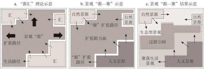
图1
“源汇”与景观“源—聚”的空间示意
Fig. 1
The schematic diagram of the "source sink" theory and landscape "source-gathering"
1.3.2 乡村文化景观的“源”
对人文景源和自然景源的界定,已有大量从景观资源视角的研究,从资源的分类和评价将建筑、街巷、活动空间等识别为自然景源,民俗、节日等识别为人文景源。该方法聚焦于客体本身主体价值对乡土文化保护的重要性,但未能从地理与历史广度认知乡村文化的本体价值[24]。对象征自然景源和人文景源的地理空间界定,仍有待从乡土景观发展和转变的溯源中挖掘隐匿的空间特征和历史价值。
乡村空间与土地利用形态的耦合互动关系,为从乡村土地转型中解析乡村文化景观的自然景源和人文景源提供了新的视角[25,26]。在景观历史变迁与文化映射的研究中,具有历史延续性的景观空间被认为能够象征一定的文化遗存[27]。Agnoletti[28]认为,如植树造林等对乡村自然用地改造和恢复的过程将导致空间的同质化,这与Marine等[29]研究中所认为的不连续的空间转变会打破原有的乡村景观使之呈现破碎化倾向的结论相契合。Tieskens等[30]和Yang等[31]也在研究中将原始林地和古树名木等未发生变迁的景观空间作为历史文化的源地开展文化价值量化与评价。未被改造的林、田、湖、草等空间既是乡村历史遗产的保护对象,也是未来发展的关键资源。因此,从景观空间特征形态所具有的人文和自然属性,对历史性水体、林地、草地、耕地和建设用地所表征的山水林田湖草—人居景观进行景源界定。其中,自然景源是以自然元素为核心的景观空间,水体、林地、草地景观为典型的生态要素,农田本质是一种生态资源,构成了村落聚居地外围的基本生态空间[32]。人文景源是能表征人类文化活动的主要场所。乡村聚落人文景观不仅是传统民居庭院等实体,其空间结构、街巷肌理、建筑格局等都是文化景观的核心内容[24]。乡村建设用地是涵盖建筑、街巷和生产生活活动的基本单元,建设用地的扩张与转移集中体现着制度、经济等内生和外生需求[27]。基于此,本文从景观空间转移的文化映射关系,界定乡村具有历史延续性的林地、水域、耕地、草地为历史乡土景观的自然景源,未转变的建设用地作为具有历史乡土记忆的文化景源。
1.3.3 “源—聚”过程模拟与分区保护
自然物质空间形态的分化重塑促进空间功能复合,以乡土生态自然景源和以聚落实践为基础的人文景源的聚合,可通过空间扩张模拟人地物质能量交换动态来表现自然景源与人文景源间用地的扩张与平衡。自然景源空间扩张表现为生态敏感性的行为约束,而人文景源空间的扩张表现为主体的实践过程,两者互为驱动力和阻力。若自然景源扩张“阻力”小,则是以生态性为主的自然景观空间;若文化景源扩张“阻力”较小,则是以人文景观为主的文化景观空间;当不同空间扩张阻力都较小时,即人与自然复合的共生性程度高。通过对景源扩张阻力判别与过程模拟,采用适宜性分区方式形成从人文景源到自然景源依次过渡的景观存续分区,分别形成倾向于人文景观、复合景观、生态景观保护的安全格局(图2)。
图2
2 研究方法与数据来源
2.1 研究区概况
哈尔滨市宾县宾州镇位于黑龙江省南部松花江流域(127°29′18″E,45°45′40″N) (图3)。宾县作为全国粮食生产大县,其历代农耕、游牧的历史积淀,奠定了东北亚文化圈农耕文明的基本形态,促进了县域、省域乃至东北亚的联系与互动,不仅是全国休闲农业与乡村旅游示范县、国家级全域旅游示范县、黑龙江省文化先进县,更被誉为“中国民间文化艺术之乡”。然而,宾县宾州镇作为全国千强镇,其现代化城镇建设、产业更新与经济建设引发的空间重组,导致其历代农耕等乡土文化景观在商业建筑、工业厂房等建设中逐渐萎缩,其境内所辖的166个自然村落在新型城镇化建设中,正面临地域文化传承与保护的现实需求,面临着文化价值认知和人地平衡的矛盾,亟待从乡村现代化转型中探索乡土文化的活态保护路径,为自然村落乡土文化的层级保护提供思路。
图3
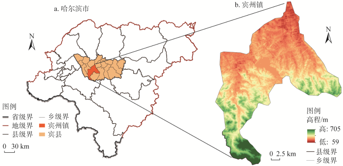
图3
研究区地理区位
Fig. 3
Geographical location of the study area (Binzhou town, Binxian county, Harbin)
2.2 数据来源与处理
研究数据包括自然空间数据、社会统计数据及POI数据。自然空间数据包括土地利用数据、高程、植被覆盖度、道路与村落分布等。土地利用数据精度为30 m,1980年数据来自中国科学院地理科学与资源研究所资源环境科学与数据中心(
2.3 研究方法
2.3.1 景观空间变迁与景“源”的识别
2.3.2 村落空间活跃度的核密度估计
POI数据是地理空间承载人类活动相关信息的集合,是表征受公众关注及人类活动像素点的空间分布[34]。本文通过建立300 m×300 m的渔网对POI数据完成单元范围内的数量统计,以表示单元范围内的活跃度。在面转点的基础上,通过核密度统计实现人类活跃度在空间上的可视化表达。
2.3.3 最小阻力模型(MCR)的空间演变模拟
式中:MCR为最小累计阻力值;f为空间中任意一点的最小阻力与源的距离和景观基面特征的正相关关系;Dij为从源地j到景观单元i的空间距离;Ri表示景观单元i对某种运动的阻力系数。
该模型通过“源”到各景观单元所耗费的费用或加权距离测算其最小阻力值,在本文中应用于测算景源空间向外扩散运动的阻力,以期扩张过程中的最小阻力值的差值作为耦合适宜性建设的程度,计算公式如下:
式中:MCR自然景源为自然景源扩张的最小阻力值;MCR人文景源为人文景源扩张的最小累计阻力值;MCR差值为自然景源扩张与人文景源扩张最小累计阻力的差值。利用自然断点法根据MCR差值的值进行景观分区,MCR差值越大,即代表自然景源的阻力值越大,人文景源的阻力值越小,越靠近居民点中心,景观受到生产生活形塑的可能性越大,空间更具有人文景观属性;相反,MCR差值越小,区域越接近自然景源,越保留有完整的自然属性空间,越适合规划为自然生态保护区。
3 结果分析
3.1 宾州镇景观变迁与景源提取
根据景观类型识别结果分析1980—2020年间宾州镇不同时期的景观变迁情况 (图4),发现自1980年以来,中部由林地到草地、耕地到草地的转移明显,其中1980—2000年林地、耕地、草地之间的不规则面状转移显著。而在2000—2020年转移情况有所减缓,除中部建设区域的扩张和耕地与水域转换外,边缘线性的转移呈主要变化特征,各用地主体的核心区域保护完整。
图4
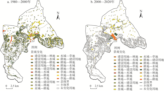
图4
宾州镇1980—2020年景观变迁
Fig. 4
Landscape changes in Binzhou town from 1980 to 2020
根据景观变迁的历史用地分析,将40 a间未发生变化的农田、林地、草地、水域确定为自然景源源地,未发生改变的建设用地确定为人文景源源地(图5)。其中自然景源源地面积为242.94 km2,包括耕地150.36 km2、林地85.72 km2、草地0.35 km2、水域6.51 km2;人文景源源地面积为7.89 km2,主要分布在宾州镇北部区域。
图5
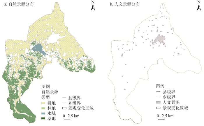
图5
宾州镇自然景源与人文景源提取
Fig. 5
Extraction of natural and human landscape sources in Binzhou town
3.2 基于MCR模型的景观“源—聚”模拟
3.2.1 综合阻力面构建
表1 自然景源与人文景源扩张因子及权重
Table 1
| 阻力因子 | 分级标准 | 权重 | |||||
|---|---|---|---|---|---|---|---|
| 水域缓冲区/m | >120 | 60~120 | 30~60 | 10~30 | 0~10 | 0.23 | |
| 植被覆盖度 | <0.2 | 0.2~0.4 | 0.4~0.6 | 0.6~0.8 | >0.8 | 0.10 | |
| 坡度/(°) | 0~3 | 3~8 | 8~15 | 15~30 | >30 | 0.12 | |
| 高程/m | 59~100 | 100~200 | 200~350 | 350~500 | >500 | 0.05 | |
| 道路缓冲区/m | <50 | 50~100 | 100~150 | 150~200 | >200 | 0.29 | |
| 土地利用类型 | 自然景源 | 建设用地 | 耕地 | 水域 | 草地 | 林地 | 0.21 |
| 人文景源 | 建设用地 | 耕地 | 林地 | 水域 | 草地 | ||
| 自然景源扩张阻力值 | 90 | 70 | 50 | 30 | 10 | ||
| 人文景源扩张阻力值 | 10 | 30 | 50 | 70 | 90 | ||
图6
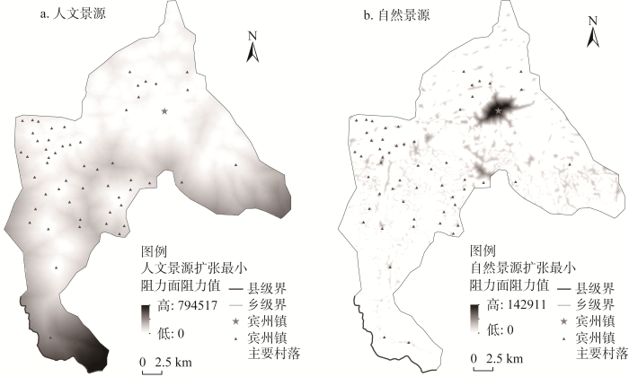
图6
自然景源与人文景源扩张的最小累计阻力面空间分布
Fig. 6
Spatial distribution of minimum cumulative resistance surface for expansion of natural landscape source and human landscape source
3.2.2 基于MCR差值的景观空间分区
本文中对靠近自然景源的MCR差值最高阈值到靠近人文景源的MCR差值最低阈值,参考寇怀云等[21]对乡村从聚落生活区到生态区的圈层结构划分、王建英等[36]对乡村自然—文化安全格局的界定,围绕用地适宜性原则,利用自然断点法将景观“源—聚”的文化景观空间划分为生态核心区、生态过渡区、共生缓冲区、生活过渡区、聚落生活区。其中,生态核心区综合阻力值最高,是具有良好生态基础的空间;生态过渡区综合阻力值较高,仍以自然景观为主,不适宜进行建设与开发性活动;共生缓冲区是介于自然生态景观与主体活动区的过渡空间,应注重屏障干扰与生态保护;生活过渡区阻力值较低,为核心聚落空间的外围区域;聚落生活区综合阻力值最低,为主要的文化交流活动空间。各分区的MCR差值及特征见表2。
表2 景观分区特征表
Table 2
| 景观分区类型 | MCR差值 | 分区特征 |
|---|---|---|
| 生态核心区 | -794516.8~ -526401.9 | 靠近自然源地,生态良好 |
| 生态过渡区 | -526401.9~ -320724.7 | 生态缓冲区,不宜开展建设性活动 |
| 共生缓冲区 | -320724.7~ -181158.1 | 自然与人居活动的过渡空间 |
| 生活过渡区 | -181158.1~ -78319.5 | 人居动态空间外围具有自然属性的空间,可开展景观建设 |
| 聚落生活区 | -78319.5~142048.9 | 居民活动核心区,主要的生产生活空间 |
3.3 宾州镇景观“源—聚”的空间分布
从景观“源—聚”空间演变结果来看(图7),聚落生活区是宾州镇主要景观空间,主要位于宾州镇北部和南部中心村落密集的区域;生活过渡区呈连续的条带状沿田园聚落区的外围分布,区域内有少量的村落零星散布;共生缓冲区呈不连续的条带状和块状分布在宾州镇南部靠近边界的区域;生态过渡区介于原生郊野区外围;生态核心区为空间内最小的景观分区,分布在镇域最南端。分区具有明显的圈层结构,并与村落分布、空间活跃度和用地性质存在不同程度的相互作用与耦合关系。
图7
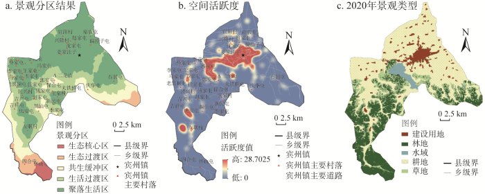
图7
景观分区结果、空间活跃度与2020年景观类型
Fig. 7
Landscape zoning results, spatial activity and landscape types in 2020
结合村落分布、空间活跃度、土地利用现状的空间分布,聚落生活区以建设用地、耕地和草地为主,村落分布密集、空间活跃度高,构成了典型的乡村田园聚落系统,反映聚落日常生产生活的基本空间遵循,区域内建筑、街巷、民俗、农耕等人文化要素是核心的景观资源,但由于经济产业发展的需求,正面临产业结构重组和风貌趋同化的威胁。生活过渡区和共生缓冲区以耕地、草地和林地为主,在土地利用上具有典型的过渡特征。区域内村落围绕聚落生活区散布,空间活跃度较低,形成了聚落—农田—山水—林地相适应的结构,反映了村、田、自然相依存的空间关系,维持区域人与自然交互的平衡关系,应加强保护区域内各要素的完整性、延续其生长演变规律。生态过渡区和生态核心区以草地和林地为主,村落数量少且边缘化特征明显,空间活跃度低,应将发展重点落在识别和保护自然基底的本体价值
3.4 宾州镇景观“源—聚”的空间演变探究
景观“源—聚”的核心是对人文与自然景观的溯源、特征感知和扩张融合过程的判别和模拟,探索人与自然互动中多样性元素动态性、自然分化重组可塑性的基本特征。其中,景源的分布、物质能量流动过程中的干扰阻力是影响景观“源—聚”结果的重要因素,乡村地质地貌及其在聚落选址、形态分化和生产活动等方面的总体特征,导致了宾州镇南部自然景源相对完整、中部和北部破碎化明显的空间分布,决定了景观“源—聚”的圈层空间结构。
首先,宾州镇北平原、南丘陵“五分半水四分半田”的自然风貌特征,决定了北农田、南山体林地的总体景观资源分布,直接影响着乡村景观的基本格局和村落的分布脉络。宾县作为全国粮食生产大县,早期村落多选址在北部黑土肥沃的平原地区,围绕中心城区向外扩散,且各村落间始终保持相对独立,因此人文景源区域集中在宾州镇北部,除宾州镇主城区外均成点状散布。其次,人类的生产活动和生活倾向性,影响和形塑着自然景源的基本形态。中部农田—林草的交错带,在早期农业用地扩张开荒到退耕还林、退耕还草的生产活动影响下,农田、森林与草地资源间持续转移,导致了其景源边缘的破碎化。而南部山体林地等距离中心聚落偏远,受人为干扰较小,其景源的完整性高。
在景源扩张的阻力面中,通过生态敏感性约束所建立的景源扩张阻力面,地质地貌、土地覆被类型等是主要阻力因素。宾州镇北部和中部开阔的平原地貌为村落间的联系提供了便利,促进了道路交通、农田产业、经济活动等的建设和开展,为集中连片的农业机械化作业和生产提供保证,形塑了具有高度连通性的区域化生产生活景观,能够满足区域间人员来往和文化交流的基本空间需求,使得宾州镇北部和中部形成了以聚落生活区为主的景观空间。同时,基于由中部向外围农田—草地—林地的土地利用结构,生产生活空间逐步扩张的自然改造活动受限,景源在逐渐融合和转化的过程中形成从聚落生活区到生态区的圈层结构。
3.5 景观“源—聚”空间演变的村落文化保护
3.5.1 景观生态性与文化传承性的空间遵循
以景观“源—聚”中的景观空间属性为基础,聚落生活区作为历史性人文积淀和村落主体基本文化交流的空间,在当前现代化建设和产业结构的调整中,应在挖掘区域历史人文风貌及文化价值的基础上对人工化建设进行管控,以历史文化遗产地为核心,发挥村落主体在文化传承与保护中的自主性,集中力量以地域性的文化认同实现乡村文化的传承。生活过渡区和共生缓冲区中生产、生活、生态功能空间的转型分化时有穿插,在村落重组与景观开发保护中应侧重从人文生态系统整体的角度出发,保持聚落—农田—林地—水体间的相互依存关系,挖掘和延续各功能空间的演进机制,可尝试催生具有特殊形态与价值的景观空间作为特色开发的突破点。生态过渡区和生态核心区作为村域保存较完整的生态空间,应遵循生态保育和修复原则,注重对自然基底的保护和修复,保持和顺应林木山水的自然走势。
3.5.2 景观“源—聚”空间特征的村落发展定位
根据景观“源—聚”的空间分区结果对村落发展进行定位(图8a)。宾州镇村落多分布在聚落生活区内,其次是生活过渡区和共生缓冲区。发掘区域内的人文底蕴、预防外力大规模的破坏、激活主体文化创造活力,是聚落生活区内村落文化保护的基本定位。区域内如宾州镇主城区,以及沈家屯、赵家屯等坐落于主城区边缘的村落,受中心区域经济建设与产业发展的辐射效应,向现代化新农村建设的趋势突出,形成以主城区为主的中心聚落群,应发挥其中心文化的引领和带动作用。但其现代化产业发展重塑的生产、生活、生态空间结构,忽视了乡土文化传承保护的内在需求,导致了当前文化优势不突出、凝聚力不强等问题。应提高对传统风貌和乡土价值的挖掘和保护力度,加强预防“一刀切”的人工化景观建设,从城乡统筹视角促进精神文化价值传承与社会价值凝聚。如马家屯等分布在聚落生活区西部的村屯,紧邻宾县交通要道且靠近主城区,大量村落的散布使之成为中心聚落的附属聚落群,需发挥其附属链接优势,加强中心与外围的联动。延续村落发展肌理、维持人文复合的系统性,是生活过渡区和共生缓冲区内村落文化保护的基本定位。如郭安屯、吉祥屯等位于过渡带的村落,考虑生态敏感性与景观可塑性,发掘空间文化载体,可通过村落空间肌理结构梳理、传统建筑修缮、古树名木保护等协调人文风貌与生态,保留好村域内原真原色传统气息的同时形成良好的生态屏障。保护和修复自然基底、维护生态完整性是生态过渡区和生态核心区内村落的基本定位。如四合屯、怀山屯等可对原生风貌进行微介入,立足重保护和强修复重现古朴、纯正的半自然化和自然化景观。从村落的文化发展定位和集聚模式综合形成“中心—附属—外围”的层级传递与联动模式。
图8
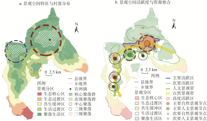
图8
景观空间特征与村落分布和景观空间活跃度与资源整合
Fig. 8
Landscape spatial characteristics and village distribution and landscape spatial activity and resource integration
3.5.3 景观“源—聚”空间活跃度的文化资源整合和串联
空间活跃度既包含对人地物质能量交换的场所使用强度,也反映着空间对当地居民的吸引力。空间活跃度较强的中心区域(图8b),即宾州镇中北部,作为中心活跃集群,辐射和带动着北部和东南侧的附属活跃集群,沿聚落—农田主体脉络构成主体文化活动空间。位于西侧和南侧的以英杰乡、庆华村、友联村为核心的活跃区则构成外围活跃集群,在空间上呈现向自然景观区域延伸的特征,整合了如英杰乡风景区、二龙山风景区等自然景观,集合构成聚落—农田—林地—水体生态人文景观结构。综合景观“源—聚”的空间属性与活跃度,对乡土景观资源进行整合,分别形成人文景观为核心和以自然景观为核心的景观带,形成活跃集群辐射、自然景观联动、人文景观互动的空间结构。
4 结论与讨论
4.1 结论
城市化与城镇化的内外双向牵引,加快了自然村落合并、搬迁与硬质化改造的趋势,亟待从乡村人地互动的内在逻辑与价值认知开展结构调整的规划指引。本文在借鉴“源汇”理论的基础上,解读了“源汇”理论应用于传统乡村景观保护的空间指导性意义,探讨了将“源汇”嵌入文化景观进而拓展为景观“源—聚”的可行性,创新了景观“源—聚”解读文化空间格局的分析模式,并首次将其转化应用于乡村文化景观保护。以宾州镇为例分析了景观“源—聚”的空间演变过程及分区特征,揭示了宾州镇自然地貌与生产活动倾向对乡村文化景观圈层结构塑造的重要性,并从景观“源—聚”分区的空间本体价值解析中构建文化保护的区域性框架。具体结论包括:
(1)“源汇”物质能量流动、演变和转化过程的空间分析,为乡村文化景观溯源、特征感知和扩张融合过程模拟提供了基础理论和模式。结合文化景观自然与人文元素多样性互补的发展过程,将“源”和“汇”的空间互斥拓展优化为表征自然与人文历史性交替的景观“源—聚”,创新了景观“源—聚”的空间分析方法,突破了对村落中单一要素和局部信息片面化关注的局限,最大程度地从地理空间的深层次系统性探索景观演替过程与人地关系,为实现可持续的乡土文化保护搭建系统性网络。
(2)研究识别宾州镇人文景源源地面积7.89 km2,集中在宾州镇北部,除宾州镇主城区外均成点状散布;识别自然景源源地面积242.94 km2,其中中部和北部自然景源破碎化程度高,南部则相对完整,综合反映了乡村地形、聚落分布和历史性生产活动的基本特征,明晰了宾州镇地理空间中具有历史延续性的景观区域,从空间和时间维度认知了宾州镇地理范围内文化联系和生态保护的本体价值。
(3)景观“源—聚”结果发现,宾州镇以聚落生活区为主形成了明显的圈层结构,分区结果与村落分布、空间活跃度和用地性质存在不同程度的相互作用与耦合关系。其中聚落生活区内村落具有集群发展效应,在现代化建设与转型中应预防过度人工化的问题,注重对传统风貌的保护,持续激发村落主体的文化创造活力。生活过渡区和共生缓冲区应从人文复合的系统性维持和延续发展的基本逻辑,深度梳理村落传统肌理挖掘潜在文化价值,维持区域人与自然的平衡关系。生态过渡区和生态核心区应注重自然基底的保护和修复。
(4)结合宾州镇村落空间集群效应与空间活跃度,宾州镇可从聚落集群的发展转型与文化保护定位中,综合形成“中心—附属—外围”的层级传递与联动模式,同时整合乡土资源构建核心文化景观带,打造活跃集群辐射、自然景观联动、人文景观互动的村落文化与生态保护系统性网络。
(5)结合当前中国乡村文化保护现状,乡村振兴视域下的乡村文化景观价值实现与保护,应立足村落的人地平衡关系,从地理空间和历史延续的广度上认知乡村文化的本体价值和发展趋势,以人地互动的基本空间逻辑构建区域化层级嵌套的系统性保护模式。对处于现代化发展转型与乡土化适应性改造的村落,应在明确其文化价值及发展定位的基础上重塑其景观与人文风貌。
4.2 讨论
研究通过景观空间的时空动态性变化界定景源,耦合了空间维度的动态性和时间维度的延续性,并采用景观扩张阻力模拟的方式判别景观的演进和互动特征,保证了村落文化景观价值分析的完整性。但景观资源评价与景源界定的方法,仍有待结合系统的分类评价方法将其完善细化至微观层面。另外,对景观“源—聚”分区中文化保护的具体措施,如激活主体文化创造活力、过度化人工景观的预防措施等,仍需要在后续研究中进一步深入探讨,逐步形成和完善景观“源—聚”文化保护的体系。
参考文献
The core of China's rural revitalization: Exerting the functions of rural area
DOI:10.1108/CAER-02-2019-0025
URL
[本文引用: 1]

The purpose of this paper is to provide a deeper understanding of the rural revitalization strategy, from the perspective of the fundamental functions that should be served by China’s rural areas in the implementation of this strategy.
乡村振兴目标下的国土整治研究进展及关键问题
DOI:10.31497/zrzyxb.20211202
[本文引用: 1]
中国国土整治历经40年发展,在促进乡村耕地保护、解决土地资源低效利用问题、助力扶贫攻坚等方面发挥了重要作用。回顾中国国土整治事业发展历程,基于文献计量分析与文献综述方法总结相关研究进展,提出了未来国土整治研究的关键问题,得到以下结论:中国国土整治事业与研究都历经国土整治规划、专项国土整治、国土综合整治三个阶段,促进乡村振兴是当前国土整治的最重要历史任务;目前形成了以解决国土空间与资源利用问题为目标,以服务政策管理需求为导向,以土地利用研究为理论支撑,以农用地整治、农村居民点整治、国土综合整治等为主要对象并向国土空间生态修复拓展的研究体系;形成了包括业务管理部门与特色科研单位为核心的分散组团式研究群体;乡村振兴目标下的国土整治研究围绕土地整治规划选址与分区决策、土地整治项目全流程监测监管与绩效评价、农村居民点整治潜力评价、土地整治政策成效评估等现实需求以及土地整治驱动生态系统变化机制、土地资源优化配置方法、土地利用冲突协调机制等科学问题开展了大量特色研究,充分发挥地理学经世致用特点。面向未来国土综合整治研究,应重点围绕“理论框架—问题识别—规划决策—技术体系”解决关键问题,以理论研究推动中国国土整治事业发展,为促进乡村振兴目标实现做出贡献。
Research progress and key issues of territory consolidation under the target of rural revitalization
DOI:10.31497/zrzyxb.20211202
[本文引用: 1]
After nearly 40 years of development, China's territory consolidation has played an important role in promoting rural farmland protection, solving the problem of inefficient use of land resources, and helping poverty alleviation. This article reviews the development process of China's territory consolidation, summarizes relevant research progress based on bibliometric analysis and literature reviews, and puts forward key issues for future territory consolidation research. The following conclusions are drawn: China's territory consolidation undertakings and research have gone through three stages including territory consolidation planning, special territory consolidation projects, and comprehensive territory consolidation. The promotion of rural revitalization is the most important historical task of current territory consolidation. At present, territory consolidation research has formed a distinctive research system with the goal of solving the problem of land space and resource utilization and guided by policy management needs. Land use research is the theoretical support of territory consolidation, with agricultural land consolidation, rural settlement consolidation, comprehensive land consolidation and land-space ecological restoration as the main objects. Territory consolidation research formed a decentralized group consisting of management departments and characteristic scientific research institutes as the core research bodies. The territory consolidation research under the rural revitalization goal focuses on land consolidation planning, project site selection, consolidation zoning decision-making, land consolidation project full-process monitoring and supervision and performance evaluation, rural settlement consolidation potential evaluation, land consolidation policy effectiveness evaluation and other management needs. Besides, much research has been carried out on scientific issues such as the mechanism of land consolidation driving ecosystem change, the optimal allocation method of land resources, and the coordination mechanism of land use conflicts, giving full play to the characteristics of geography for theory serving practice. To accelerate comprehensive land consolidation in the future, we should focus on solving key issues around "theoretical framework-problem identification-planning and decision-technical system", and use theoretical research to promote the development of China's territory consolidation, and contribute to the realization of rural revitalization.
“三生”功能视角下乡村景观时空演变及影响机制研究: 以顺德杏坛北七乡为例
Research on spatial-temporal evolution and influencing mechanism of rural landscape from the perspective of production-living-ecological function: Taking the north seven rural area of Xingtan in Shunde
The cultural values model: An integrated approach to values in landscapes
DOI:10.1016/j.landurbplan.2007.07.003 URL [本文引用: 1]
基于中国传统文化审美视角的乡村景观意象营造研究
Study on rural landscape image construction based on Chinese traditional culture aesthetic perspective
江苏省乡村聚落的形态分异及地域类型
DOI:10.11821/xb201204008
[本文引用: 1]
基于江苏省2007/2008 年SPOT卫星影像,运用探索性空间数据分析、空间韵律测度等模型,定量分析了江苏省乡村聚落形态的空间分异特征,并进一步划分了地域类型.结果表明,在空间分布上,江苏省乡村聚落的集聚特征较为明显,但存在明显的空间差异性,具体表现为由沿江地区依次向北、向南呈阶梯状稀疏化分布,其整体分布与地貌类型具有较高的相关性;在规模上,江苏省乡村聚落的规模普遍偏小,小村庄的规模差距较小,规模大的村庄比重小但是差距大;乡村聚落规模分布具有低值集聚的特征,并且呈现出明显的“哑铃状”结构,即江苏北部地区和南部地区乡村聚落规模较大,而中部地区乡村聚落规模较小.在形态格局空间变化上,通过苏北、苏中、苏南地区和沿海与沿运河地区的5 条样带的格局指数测度,发现苏中地区的乡村聚落形态复杂程度高于苏北和苏南地区,沿海地区的高于沿运河地区;苏南、沿运河地区的乡村聚落具有较好的连接性;5 条样带的乡村聚落规模分异均比较明显.最后,通过构建乡村聚落形态测度指标体系,采用系统聚类的方法,将江苏省乡村聚落划分为8 种类型:徐连岗岭低密度大团块型、宿淮平原中密度宽带型、沿海垦区高密度条带型、苏中圩区中密度弧带型、江南平原中密度小团块型、湖荡岗地低密度散点型、宁眙丘陵团簇状散布型、里下河低密度团簇型.
Morphological difference and regional types of rural settlements in Jiangsu province
DOI:10.11821/xb201204008
[本文引用: 1]
Based on the SPOT satellite images of Jiangsu Province in 2007/2008, using models such as exploratory spatial data analysis and spatial metrics, the paper conducts a quantitative analysis of the space differentiation of rural settlements in Jiangsu Province, and further identifies the regional types. The results are shown as follows. In spatial distribution, the rural settlements in Jiangsu are characterized by obvious concentration with evident spatial variability, which is shown in the ladder-like sparse distribution towards the north and south in areas along the Yangtze River with high correlation in the overall distribution and geomorphic types. In the scale, the rural settlements in Jiangsu are generally in small scale with small difference in the scale of small villages and large gap in the scale of large villages which account for a small proportion. The rural settlements in Jiangsu are characterized by low concentration in size distribution, and is obviously presented in the "dumbbell" structure, namely, the rural settlements in northern and southern Jiangsu are in a large scale, and those in the central part are in a relatively small scale. In the spatial change of form and pattern, through the measurement of the pattern indices of the five transects in the northern, central and southern Jiangsu, the coastal area and areas along the Grand Canal, it was found that the form of the rural settlements in central Jiangsu is more complex than that in the northern and southern parts of the province, and the form of coastal area is more complex than that in areas along the canal. The rural settlements in southern Jiangsu and areas along the canal are characterized by good connectivity. The rural settlements in the five transects are significantly differentiated in distribution. Finally, through establishing the morphological measurement index system of the rural settlements, by adopting the method of hierarchical cluster, the rural settlements in Jiangsu are divided into eight types: Xulian hillock (low-density large-mass type), Suhuai plain (medium-density broad-band type), coastal reclamation area (high-density stripe type), polder area in central Suzhou (medium-density arc-belt type), plain south of the Yangtze River (medium-density small-mass type), lake mound land (low-density point-scattered type), Ningyi hilly region ( cluster-like dispersal type), and Lixiahe area (low-density cluster-like type).
山地乡村景观研究进展
Progress of mountain rural landscapes research
乡村景观空间演变的文化解读: 以珠江三角洲为例
Cultural interpretation of the spatial change of rural-scape: Taking Zhujiang Delta as example
乡村景观格局特征及演变中的多尺度空间过程探索: 以乌镇为例
Exploration of multi-scale spatial process in the characteristics and evolution of rural landscape pattern: A case study of Wuzhen
时空维度下的湖州地区乡村景观格局演变分析
Analysis on the evolution of rural landscape pattern in Huzhou under the spatial and temporal dimension
“源”“汇”景观理论及其生态学意义
Source-sink landscape theory and its ecological significance
Community patterns in source-sink metacommunities
DOI:10.1086/378857
PMID:14618534
[本文引用: 1]
We present a model of a source-sink competitive metacommunity, defined as a regional set of communities in which local diversity is maintained by dispersal. Although the conditions of local and regional coexistence have been well defined in such systems, no study has attempted to provide clear predictions of classical community-wide patterns. Here we provide predictions for species richness, species relative abundances, and community-level functional properties (productivity and space occupation) at the local and regional scales as functions of the proportion of dispersal between communities. Local (alpha) diversity is maximal at an intermediate level of dispersal, whereas between-community (beta) and regional (gamma) diversity decline as dispersal increases because of increased homogenization of the metacommunity. The relationships between local and regional species richness and the species rank abundance distributions are strongly affected by the level of dispersal. Local productivity and space occupation tend to decline as dispersal increases, resulting in either a hump-shaped or a positive relationship between species richness and productivity, depending on the scale considered (local or regional). These effects of dispersal are buffered by decreasing species dispersal success. Our results provide a niche-based alternative to the recent neutral-metacommunity model and have important implications for conservation biology and landscape management.
基于“源汇”格局的传统乡村景观保护与导控策略
Traditional rural landscape protection and control strategy based on the "source-sink" pattern
基于“源—汇”理论的海口城市景观格局与热岛效应响应机制
Urban landscape pattern and response mechanism of heat island effect based on "source-sink" theory of Haikou city
空间治理: 乡村振兴发展的实践路向: 基于Q市“美丽乡村建设”的案例分析
Analysis on the path of rural spatial governance from the perspective of rural revitalization: Based on the case analysis of "beautiful countryside construction" in Q city
基于主导土地覆被的传统乡村景观区划及特征研究: 以粤东福佬区域为例
Research on traditional rural landscape zoning and characteristics based on dominant land cover: A case study of the Fulao district in East Guangdong
文化景观视角下的福建河坑村土楼群自然景观保护与发展研究
Research on conservation and development of natural landscape of Hakka earth buildings from the perspective of cultural landscape in Hekeng village, Fujian
Investigating the time evolution of a rural landscape: How historical maps may provide environmental information when processed using a GIS
基于最小阻力模型的村域土地资源优化利用布局研究: 以栾川县三川镇部分村庄为例
Optimization of village land-use resources layout on the basis of MCR model: A case study of some villages in Sanchuan town, Luanchuan county
从“文化景观”到“文化景观遗产”(上)
From the cultural landscape to the cultural landscape heritage (Part One)
文化景观视野的乡村遗产区域性保护: 思路与模型构建
Regional conservation of rural heritage from the perspective of cultural landscape: Thinking and model building
Characteristic and marks of cultural landscape of Slovakia
自然保护地的文化景观价值演变与识别: 以泰山为例
DOI:10.31497/zrzyxb.20190904
[本文引用: 1]
中国的自然保护地具有生态和文化双重价值,文化景观作为自然与文化的交界面,如何识别其价值对中国自然保护地的管理至关重要。以泰山为例,通过古籍文献和实地勘察等方法,从历时性角度对泰山的文化景观价值演变进行剖析。研究发现,泰山文化景观价值经历了山岳崇拜的自然价值、君权神授的政治价值、佛道信仰的宗教价值、祭祀游居的民俗价值及保护利用的综合价值五个阶段。结论认为:自然保护地文化景观价值的演变具有一定的规律性:名山自然保护地的文化景观价值演变是从自然到文化再到综合、从御到民、从单一到多元、从分离到融合的过程;自然保护地文化景观价值的构成要素包括思想基础、环境条件、行为方式及空间结果四部分,具有鲜明的完整性、系统性和动态性特征。文章还对自然保护地文化景观价值的识别策略进行了讨论,为相应类型的国家公园和其他类型自然保护地建设提供参考。
The evolution and identification of cultural landscape value in protected areas: A case of Mount Tai
DOI:10.31497/zrzyxb.20190904 URL [本文引用: 1]
乡村振兴视阈下乡村文化景观的价值及实现路径
The value and realization path of rural cultural landscape from the perspective of rural revitalization
1990—2020年太行山区土地利用景观格局时空变化
Spatiotemporal patterns of land-use change in the Taihang Mountain (1990-2020)
乡村空间重构与土地利用转型耦合机制及路径分析
DOI:10.31497/zrzyxb.20220712
[本文引用: 1]
科学揭示乡村空间重构与土地利用转型的耦合发展关系,有利于为中国乡村振兴和城乡融合发展提供理论基础和实践依据。运用文献综述、理论分析阐释二者的耦合机理及驱动因子。主要结论如下:(1)重构乡村空间是对新一轮乡村转型发展要求的积极回应,土地作为乡村地域的关键发展要素,通过其利用形态的多维转化适应不同的空间重构场景。(2)乡村空间重构是土地利用转型的重要驱力,也为土地利用转型提供不竭的现实需求,土地利用的成功转型是乡村空间重构结果的显著表征,二者交互影响,存在耦合互动关系。(3)空间规划、政策制度、产业结构、利益主体及生态理念的多轮驱动机制共同对其耦合关系施加影响,不同作用机制下的作用效力、方向有所不同。(4)新时代下促进乡村空间重构与土地利用转型耦合发展的一个重要思路是全方位探寻土地利用优化转型的多维路径,总体上应立足生态文明的价值位序,以空间规划为约束机制,以产业结构升级为诱发机制,以多方利益协调为保障机制,同时创新土地政策制度机制,从而提高耦合水平,助力乡村振兴战略实施。
The driving mechanism and path analysis of the coupling development of rural spatial reconstruction and land use transformation
DOI:10.31497/zrzyxb.20220712
[本文引用: 1]
With the rapid advancement of urbanization and industrialization in China, the social structure and economic development model of rural areas and the development of spatial systems such as ecological system have changed significantly, followed by the change of land use form in different regions. Thus, revealing scientifically the coupling development relationship between rural spatial restructuring and land use transition, and discussing the coupling mechanism and optimal path are conducive to providing theoretical basis and practical basis for China's rural revitalization and urban-rural integrated development, which is meaningful both in theory and practice. This study used literature review theory to analyze and explain the coupling mechanism and driving factors of rural spatial restructuring and land use transition. The main conclusions are drawn as follows: (1) The reconstruction of rural space is a positive response to the new round of rural transformation and development requirements. As a key development element of rural region, land can adapt to different spatial reconstruction scenes through the multi-dimensional transformation of its utilization forms. (2) Rural spatial restructuring is an important driving force for land use transformation, and it also provides inexhaustible realistic demands for land use transformation. The successful land use transformation is a significant representation of the results of rural spatial restructuring, and there is a coupling interaction between the two. (3) This paper constructs a multi-wheel driving mechanism of their coupling development, the direction of the effect path is different under different action mechanisms. More specifically, spatial planning and policy system design are indispensable constraints and regulation mechanisms of coupled development; the transformation of industrial structure and the change of economic system have obvious driving and catalytic benefits in deepening the coupling relationship between the two. In addition, the coupling relationship between rural spatial restructuring and land use transformation is deeply constrained by the behavior of multiple stakeholders, so the protection and coordination of the ownership rights of relevant stakeholders should run through the coupling development from the end to the end. Finally, establishing the value order of ecological priority is of great significance to the coupling evolution process. (4) In the New Era, it is important to explore the multi-dimensional path of land use optimization to promote coupled development. On the whole, the core values of ecological civilization should be established, spatial planning should be taken as the constrained mechanism, industrial structure upgrading as the induced mechanism, multi-stakeholder coordination as the guaranteed mechanism. Meanwhile, the land policy system mechanism should be innovated. Only in this way can we improve the coupling level and facilitate the implementation of the rural revitalization strategy.
文化景观、历史遗产与乡村重塑: 以山西省大寨村为考察对象
Cultural landscape, historical heritage and rural reconstruction: Fieldwork study in Dazhai village, Shanxi province
Rural landscape, nature conservation and culture: Some notes on research trends and management approaches from a (Southern) European perspective
DOI:10.1016/j.landurbplan.2014.02.012 URL [本文引用: 1]
Protected landscapes in Spain: Reasons for protection and sustainability of conservation management
Landscape conservation efforts in many European countries focus on cultural landscapes, which are part of the cultural identity of people, have a great heritage significance, improve the living standards of local populations and provide valuable cultural biodiversity. However, despite a wide arrange of protective measures, the management of preserved areas is seldom effective for the protection of cultural landscapes. Through a multi-approach analysis, we characterise the main heritage attributes of 17 Protected Landscapes in Spain and assess their management effectiveness by quantifying the evolution of the spatial pattern inside and outside protected landscapes. Our method has proven useful to quantitatively describe the spatial-temporal patterns of change of the protected and unprotected landscapes studied. We highlight the following results: (i) the concepts of uniqueness and naturalness are not appropriate to preserve cultural landscapes; (ii) the land protection approach currently adopted is not useful for the protection of cultural landscapes, particularly of the most rural ones; (iii) the landscapes studied with greater rural features can be considered as “paper parks”. We recommend that different protection measures focused on the needs and desires of the rural population are taken into account in order to protect cultural landscapes that are shaped by traditional rural activities.
Characterizing European cultural landscapes: Accounting for structure, management intensity and value of agricultural and forest landscapes
DOI:10.1016/j.landusepol.2016.12.001 URL [本文引用: 2]
The spatial perception and spatial feature of rural cultural landscape in the context of rural tourism
The development of rural tourism in the greater Xi’an area is in full swing, which is an important indicator for the implementation of rural revitalization. However, there are certain realistic challenges such as the lack of rural culture, the destruction of cultural context, and the loss of “rurality” of tourist areas. It is of vital significance to explore, integrate and revive the rural culture by advancing the rural cultural landscape based on the concept of cultural landscape in human geography. The specific categories of the rural cultural landscape were divided into three perspectives of agricultural production, famers’ lifestyle, and countryside ecology. Spatial reflections of various rural cultural landscapes were carried out based on pluralistic new data. The spatial characteristics of cultural landscapes were studied by using kernel density analysis and creating Thiessen polygons analysis and interpolation in ArcGIS spatial analysis, in order to show the spatial patterns of the special rural cultural areas and the cultural landscapes in greater Xi’an. Above all, our study inventoried and mapped the rural cultural landscapes in the context of rural tourism, identified spatial features of rural cultural landscape and rural tourism, and we proposed solutions that promote the cultural quality of rural tourism which are of vital significance in reviving rural culture.
Centennial change and source-sink interaction process of traditional agricultural landscape: Case from Xin'an traditional cherry cultivation system (1920-2020)
In contrast to modern agriculture, long-standing traditional agricultural practices such as agricultural heritage systems (AHS) are important inspirations for promoting harmonious human–land relations. However, some AHS have been in danger as their traditional agricultural landscapes (TALs) were changed by rapid modernization and urbanization. Thus, how do we figure out the change processes? What conservation measures can be taken? Taking the Xin’an Traditional Cherry Cultivation System in the loess hilly areas of Henan Province as a case, this study introduced the source–sink landscape theory to analyze the structure and process of the TAL during 1920–2020. Results show that, during 1920–1950, the traditional rural landscape (TRL) and the agricultural (natural) ecological landscape (ANEL) in the TAL were relatively balanced because they were source and sink to each other. Since 1985, the source expansion and sink resistance of both TRL and ANEL have been greatly hindered by the sink growth of modern village landscapes (MVL). As the core source landscape, TRL needs salvage protection for inheriting local characteristics by effective measures. TAL conservation should highlight rurality preservation through expanding the protection scope of TRL, endowing the MVL with more indigenous cultural features, etc. All these may contribute to rural vitalization and sustainable development.
景德镇陶瓷文化景观变迁中的人地关系和文化认同
The man-land relationship and cultural identification under the changes of Jingdezhen cultural landscapes
基于兴趣点(POI)大数据的人地关系研究综述: 理论、方法与应用
Overview of man-land relationship research based on POI data: Theory, method and application
Estimating habitat isolation in landscape planning
DOI:10.1016/0169-2046(92)90060-D URL [本文引用: 1]
生态约束下的乡村旅游用地空间布局规划研究: 以福建省晋江市紫星村为例
Land layout of rural tourism site based on ecological restraint: A case study of Zixing village in Jinjiang city, Fujian province
基于MCR模型的水网平原区乡村景观生态廊道构建
Construction of rural landscape ecological corridor in water network plain area based on MCR Model
Traditional land uses enhanced plant biodiversity in a Mediterranean agro-silvo-pastoral system
DOI:10.1080/11263504.2014.943319 URL [本文引用: 1]
大别山革命老区旅游地“乡土—生态”系统韧性演化规律及影响机制
DOI:10.31497/zrzyxb.20220707
[本文引用: 1]
探讨旅游地“乡土—生态”系统演化,为理解人地关系地域系统结构与功能演变提供了新思路。通过构建“乡土—生态”系统韧性评价体系,解析2005—2019年大别山革命老区旅游地“乡土—生态”系统韧性的演化阶段、过程、路径及机制。结果显示:(1)研究区旅游地“乡土—生态”系统经历了利用、保存、释放、重组适应性循环过程,分别对应旅游地迅速发展期(2005—2009年)、发展成熟期(2010—2012年)、发展过渡期(2013—2016年)和再发展初期(2017—2019年)。(2)在适应性循环过程中研究区县域的数量结构经历了以“较低水平韧性为主→高水平韧性为主”的转变,县域“乡土—生态”系统韧性水平呈波动上升趋势。(3)2005—2019年研究区旅游地“乡土—生态”系统韧性演化的驱动因子由经济层面转向社会文化层面。在内外源因素的作用下,旅游地“乡土—生态”系统韧性通过乡土资源禀赋(向心凝聚力)、经济发展基础(核心推动力)、社会保障功能(重要支撑力)和自然环境本底(基础约束力)的四维驱动,以人的行为为媒介在相互作用和掣肘中演进,当韧性指数超过阈值时其内核组织将打破原有边界、自我调适实现“路径突破”,进入下一阶段适应性循环,以此促进旅游地的可持续发展。
The resilience evolution and influencing mechanisms of the "ruralism-ecology" system of tourist destinations in Dabie Mountains Old Revolutionary Base Area
DOI:10.31497/zrzyxb.20220707 URL [本文引用: 1]
