

随着城镇化、工业化的不断推进,中国乡村从注重农业生产,发展至承担社会稳定、生态保障等多种功能[1],为支撑经济社会发展提供了不可替代的价值。为进一步激活乡村发展的内生动力,《中共中央 国务院关于实施乡村振兴战略的意见》明确指出要“挖掘乡村多种功能和价值”。乡村地域多功能的拓展和提升,既是指导乡村多元发展的理论依据,也是促进城乡融合发展的客观基础[2]。如何充分挖掘乡村地域多功能,促进城乡资源要素自由交互,进而形成高效有序的城乡融合,成为当前社会各界关注的重要内容之一。然而,由于边界效应以及资源要素跨区域流动的特征,使得当前个体化的乡村功能提升思路存在一定的资源浪费和区域冲突,也不利于区域的城乡融合水平整体提升[3]。此外,近年来不同乡村地域之间除了“自然生态”与“地域文化”的强烈黏性以外,经济社会发展的相互依存程度也快速上升,促使乡村地域多功能在空间上彼此关联[4],并形成较复杂的空间关联网络结构。因此,亟需探究乡村地域多功能的空间关联网络特征,从而有效识别各乡村地域在空间关联网络中的地位和角色,并深入揭示网络结构特征对于城乡融合发展的影响机制,为制定跨区域协同的乡村功能提升方案和城乡融合发展机制提供决策参考。
国内外学者针对乡村地域多功能的研究主要有以下方面:(1)科学内涵及政策启示[5]。Potter等[6]以及Holmes[7]探讨了乡村地域多功能的内涵,刘玉等[8]探讨其对中国乡村发展的启示。相关启示主要以“多元化”和“差异化”为核心思想[9],基于“多功能理论”指导乡村振兴[10]。(2)功能评价与影响因素。国内外逐渐形成以“农业生产—非农生产—居住生活—生态保障”等为框架的评价指标体系[11]。在功能评价基础上,杨忍等[12]指出乡村地域多功能受到自然地理因素和经济社会因素的综合影响,并发现社会因素的影响作用逐渐上升。(3)空间分异与类型划分。国外学者较为关注后工业社会背景的乡村地域多功能空间分异特征,国内学者主要遵循“空间分异—主导类型—发展策略”的研究思路。熊鹰等[13]指出乡村地域多功能呈现出显著的区域差异以及空间集聚特征,徐凯等[14]将乡村地域多功能的主导类型划分为综合型、农业生产型、非农生产型等。(4)功能演化与相互关系。Holmes[15]开展了乡村地域多功能转型研究,Wilson[16]、Breman[17]剖析了乡村地域多功能的系统演化和功能关系,刘玉等[18]指出经济发展与农产品生产等为显著协同关系,而与生态服务等为显著权衡关系。
现有研究对于促进乡村地域功能的拓展与提升具有重大意义,不过仍有局限之处:(1)从研究视角来看,以往研究主要从乡村地域多功能的“空间分异”和“系统演化”展开,较少考虑不同乡村地域之间的相互作用,对乡村地域多功能的空间关联关系探究不够,不利于乡村功能的区域协同提升。(2)从研究内容来看,以往研究较多关注乡村地域的自身功能属性,与宏观经济社会发展的联系不够。虽然已有研究表明乡村地域多功能与城乡转型能够相互促进[19,20],但侧重考察“属性数据”的耦合协调,并未揭示乡村地域多功能空间关联的“关系数据”对城乡融合发展的影响。因此,本文在厘清乡村地域多功能空间关联机制的基础上,阐释乡村地域多功能空间关联网络的结构特征对城乡融合发展的影响机制,并以河南省为案例区,借助社会网络分析法、面板回归模型等开展实证检验,以期促进区域乡村联动发展以及城乡融合有序高效。
1 理论分析与影响机制
1.1 乡村地域多功能的空间关联机制
乡村地域多功能的空间关联是指一定区域内不同乡村地域系统,通过直接或间接的形式进行跨区域功能互动并由此产生的关联关系[21]。刘玉等[5]指出乡村地域多功能具有“相互作用”的属性,不同乡村地域之间相互影响、相辅相成。任何乡村地域系统都不可能局限在封闭的空间中,都会与其他乡村地域发生功能互动。乡村地域多功能的互动过程包括功能疏解与弱化以及功能集聚与强化[22],其本质是在互补性、可达性、外界干扰等条件下,各类资源要素的跨区域联系和交换[23]。乡村地域多功能的跨区域交互,可以有效促进区域间的优势互补和协作共享,也有利于扩大要素和产品的市场,有效改善投入和产出的环境,从而促进整体区域的增长[24]。
乡村地域多功能空间关联网络是全球化和市场化深入乡村地域的过程中,一定区域内的乡村地域经过长期的相互影响和功能互动,其乡村地域多功能开始从散乱到有序、从同质到互补的过程中所形成的关联关系集合[25]。这些关系集合会通过循环反馈机制,对不同乡村地域的功能演化产生影响,进而推动区域整体的乡村功能由低水平向高水平演进[26]。而且,网络中不同乡村地域之间的联系通道也逐渐从道路、河流等实体通道,延展至互联网等虚拟通道等,不同乡村地域间的作用方式也不再局限于中心地联系下的层级作用,也包括非层级、水平化的作用[27]。因此,由于乡村地域多功能网络具有“形成连续性”“联系广泛性”“作用多样性”等特征[28],使得网络表现出日益复杂的整体结构。
乡村地域多功能空间关联网络的形成发展受到城乡互动的影响,同时乡村地域多功能空间关联网络也会影响城乡之间的相互作用[29]。城市与乡村是具有显著区别但密切联系的有机整体,城乡之间在要素组合和地域功能上具有明显差异,从而相互依赖、互动共生。乡村地域多功能的拓展和提升离不开城市发展的带动[30],在城市外缘系统的多元化需求和自身的内生性动力交互作用下,乡村地域之间的竞合关系进一步加强,使得乡村地域多功能空间关联网络中的节点功能差异互补、整体联系日益紧密。与之对应,由于乡村地域多功能空间关联网络的存在,乡村地域可以突破地理距离限制获得协同效应、规模借用等网络外部性[31],从而影响自身与城市的相互作用(图1)。
图1
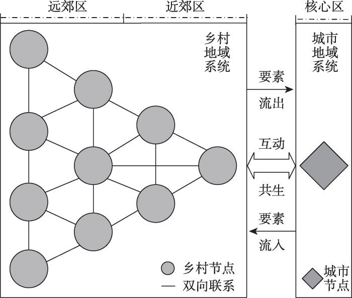
图1
乡村地域多功能的空间关联机制
Fig. 1
Spatial correlation mechanism of rural territorial multi-functions
1.2 乡村地域多功能空间关联网络结构特征对城乡融合发展的影响机制
城乡融合发展的本质是在城乡要素自由流动、公平共享基础上,促进城乡经济、社会和生态的多维融合并最终实现城乡等值化发展[32]。然而,在传统的农业农村现代化过程中,乡村往往处在注重生产性、被动服务城市的发展定位,其本身特质和多元价值一定程度上被忽视,乡村环境和社会也受到很大程度的牺牲。所以,城乡融合发展的关键在于解决乡村要素单向流出、地域功能衰退等发展受限问题。乡村地域多功能的拓展和提升能够推动乡村价值再现、城乡良性互动,并从激活乡村经济、创造就业机会、改善公共服务等方面促进城乡融合发展[33]。同时,随着乡村地域多功能空间关联网络的形成和发展,乡村地域多功能的城乡融合效应呈现网络非均衡性特征。乡村地域多功能空间关联网络虽然强调非层级性,但网络中的节点仍具有等级性,使得各乡村地域获取网络正外部性的能力存在差异,具有个体地位优势的乡村地域能够获得更多的资源要素溢出[34],从而进一步提升其城乡融合水平。因此,乡村地域多功能对于城乡融合发展具有促进作用,而且其作用效应受到乡村地域多功能空间关联网络结构特征的影响(图2)。
图2
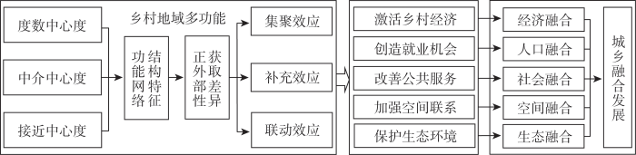
图2
乡村地域多功能空间关联网络结构特征对城乡融合发展的影响机制
Fig. 2
The influence mechanism of structural characteristics of spatial correlation network of rural territorial multi-functions on urban-rural integrated development
乡村地域多功能通过激活乡村经济、创造就业机会、改善公共服务、加强空间联系和保护生态环境促进城乡融合发展[35]。(1)经济融合。乡村地域多功能可以激活乡村经济活力,通过发展新产业、新业态、新商业模式,吸引技术、人才等资源要素的回流,有利于优化城乡资源配置、促进城乡发展机会均等。(2)人口融合。乡村地域多功能可以促进农业与第二、三产业融合发展,通过拓展产业链提升乡村价值创造和就业吸纳能力,有利于乡村人口就业和就地城镇化。(3)社会融合。乡村地域多功能可以引导基础设施建设,为持续吸引城乡消费人口,倒逼城乡基本公共服务的共建共享,有利于改善农村居民福利。(4)空间融合。乡村地域多功能可以加强城乡物质共享流通,通过乡村特色产品的有效供给、文化生态体验的本地服务,实现城乡实物运输和人口流动的紧密联系,有利于城乡空间合理分配、空间流通网络顺畅。(5)生态融合。乡村地域多功能可以重塑城乡生态格局,通过发展生态农业、休闲观光等,加强污染治理、生态修复,有利于乡村生态价值的充分实现、增强区域生态稳定。
乡村地域多功能空间关联网络的个体地位优势提升,有助于乡村地域获得更多的资源要素溢出,从而进一步提升其城乡融合水平。(1)集聚效应。乡村地域多功能网络度数中心度高的乡村节点,不仅可以通过网络联系为其他乡村节点提供资源要素溢出,也可能通过网络联系产生竞争性的资源掠夺[36]。这些“领导者”乡村节点可以通过主导要素流动和空间分工以及资源的跨地区整合,强化自身资源要素优势,从而产生集聚性的城乡融合效应。(2)补充效应。乡村地域多功能网络中介中心度高的乡村节点,可以通过嵌入先发区域并借用优势节点的规模效应,从而突破地理距离获得功能溢出[37]。这些“中介者”乡村节点可以通过影响资源要素传导和辐射,获得本地集聚外部性以外的资源要素水平提升,从而产生补充性的城乡融合效应。(3)联动效应。乡村地域多功能网络接近中心度高的乡村节点,可以发挥“直接联系”的能力与其他乡村节点进行空间交互[38],这些“行动者”乡村节点可以通过降低资源要素传输损失和信息不对称风险,与其他乡村节点进行高效的匹配、学习[39],从而产生联动性的城乡融合效应。
2 研究方法与数据来源
2.1 乡村地域多功能与城乡融合发展的综合评价
(1)乡村地域多功能的评价指标体系构建
乡村地域多功能是指乡村地域系统通过自身演化及内外交互的共同作用,在一定发展阶段内所满足人类需求的综合特征。随着城乡居民对乡村的利益需求呈现多元化,中国乡村功能已从注重农业生产转向兼顾生产、生活、生态等多种功能[9]。参考刘玉等[18]研究将乡村地域多功能划分为农业生产、非农生产、居住生活、生态保障四个维度(表1)。① 农业生产功能是乡村地域向社会提供农产品的能力。具体选用人均耕地面积、土地垦殖率、第一产业增加值反映农业发展情况,用粮食单产、人均粮食产量反映粮食生产能力,囿于蔬菜、畜产品等生产数据的可获性,用人均油料作物产量在一定程度上反映其他农产品生产。② 非农生产功能是指乡村非农经济发展能力,由于宏观统计数据难以将其直观反映,参考杨忍等[12]研究用乡村就业结构、区域非农经济活力和区域财政能力从侧面反映。乡村非农就业的占比越高、区域非农经济活力越高、区域财政能力越强,乡村非农生产功能的发展机会就越高,具体选用乡村从业人员非农就业率、第二三产业增加值、财政收入占GDP比例来表征。③ 居住生活功能是保障居民稳定生存的能力,具体选用乡村人口密度、农村电力设施、医疗卫生条件等反映居住条件,用乡村人均纯收入反映生活水平。④ 生态保障功能是乡村维持生态稳定、提供生态调节或恢复的能力,具体选用森林覆盖率反映生态环境状况,用化肥、农药、地膜的使用情况来反映乡村生态的受损情况。
表1 乡村地域多功能评价指标体系
Table 1
| 目标层 | 准则层 | 指标层 | 正逆 | 指标解释与计算方法 |
|---|---|---|---|---|
| 乡 村 地 域 多 功 能 评 价 | 农业生产功能 | 人均耕地面积/(hm2/人) | + | 耕地面积/乡村人口 |
| 粮食单产/(t/hm2) | + | 粮食总产量/粮食作物播种总面积 | ||
| 土地垦殖率/% | + | 耕地面积/行政区域面积 | ||
| 人均粮食产量/(t/人) | + | 粮食总产量/乡村人口 | ||
| 人均油料作物产量/(t/人) | + | 油料总产量/乡村人口 | ||
| 第一产业增加值/万元 | + | 来自年度统计年鉴 | ||
| 非农生产功能 | 乡村从业人员非农就业率/% | + | 乡村非农从业人员/乡村从业人员 | |
| 第二三产业增加值/万元 | + | 二三产业增加值之和 | ||
| 财政收入占GDP比例/% | + | 财政收入/GDP | ||
| 居住生活功能 | 乡村居民人均纯收入/元 | + | 农村居民实际收入水平 | |
| 乡村人口密度/(人/km2) | + | 乡村人口/乡村地域面积 | ||
| 农村电力设施/(kW·h/人) | + | 乡村用电量/乡村人口 | ||
| 医疗卫生条件/(张/万人) | + | 卫生机构床位数/区域人口 | ||
| 生态保障功能 | 森林覆盖率/% | + | 森林面积/行政区域面积 | |
| 地均化肥使用量/(kg/hm2) | - | 化肥施用强度 | ||
| 地均农药使用量/(kg/hm2) | - | 农药施用强度 | ||
| 地均地膜使用量/(kg/hm2) | - | 地膜使用水平 |
(2)城乡融合发展的评价指标体系构建
城乡融合发展是城市系统和乡村系统在开放、平等的发展环境上,通过资源要素自由流动与优化配置,推动城乡之间的人口、经济、社会、空间和生态的多维融合,并最终形成功能互补、利益共享、协同发展的良性城乡关系[32]。参考马志飞等[40]研究,构建包含“经济融合”“人口融合”“社会融合”“空间融合”和“生态融合”五个方面的城乡融合发展评价指标体系(表2)。① 城乡经济融合是通过城乡要素的差异互补和高效配置,推动城市发展的同时带动农村经济增长,具体用非农产业增加值占GDP比例、城乡投资状况反映城乡总体发展水平,用农业机械水平、城乡居民人均可支配收入比反映以城带乡的成效。② 城乡人口融合是通过城乡人口自由流动,推动城乡人口在工作就业、自身发展等方面的协调提升,具体用非农与农业从业比例、人口城镇化水平来表征。③ 城乡社会融合是通过消除城乡在社会服务和福利保障等方面的制度差异,推动城乡居民享有均等化的公共服务,具体用城乡最低生活保障、养老保险、教育经费来反映。④ 城乡空间融合是城乡通过构建城乡空间联系体系,推动城乡基础设施不断完善、城乡用地日趋合理、城乡空间流通速度不断提升,具体用土地城镇化水平、城市空间扩张、公路路网密度来反映。⑤ 城乡生态融合是通过转变生产生活方式,保障城乡生态环境稳定,具体用污染处理率、工业固体废物综合利用率、生活垃圾无害化处理率来表征。
表2 城乡融合发展评价指标体系
Table 2
| 目标层 | 准则层 | 指标层 | 正逆 | 指标解释与计算方法 |
|---|---|---|---|---|
| 城 乡 融 合 发 展 | 经济融合 | 城乡居民人均可支配收入比/% | - | 城镇居民人均可支配收入/农村居民人均可支配收入 |
| 非农产业增加值占GDP比例/% | + | 第二、三产业增加值/GDP | ||
| 城乡投资状况/(亿元/万人) | + | 固定资产投资/城乡人口数 | ||
| 农业机械水平/(kW·h/hm2) | + | 农业机械总动力/耕地面积 | ||
| 人口融合 | 人口城镇化水平/%非农与农业从业比例/% | + + | 人口城镇化率第二、三产业从业人数/第一产业从业人数 | |
| 社会融合 | 城乡最低生活保障人数比/% | - | 城镇居民最低生活保障人数/ 农村居民最低生活保障人数 | |
| 城乡养老保险参保人数比/% | - | 城镇基本养老保险参保人数/农村社会养老保险参保人数 | ||
| 人均教育经费总投入/(万元/人) | + | 教育经费/城乡人口数 | ||
| 空间融合 | 土地城镇化水平/% | + | 建成区面积/土地总面积 | |
| 城市空间扩张/% | + | 农作物播种面积/建成区面积 | ||
| 公路路网密度/(km/km2) | + | 公路运营里程/土地总面积 | ||
| 生态融合 | 污水处理率/% | + | 来自年度统计年鉴 | |
| 工业固体废物综合利用率/% | + | 一般工业固体废物利用量/一般工业固体废物总量 | ||
| 生活垃圾无害化处理率/% | + | 来自年度统计年鉴 |
(3)综合评价模型
采用综合评价模型评价乡村地域多功能与城乡融合发展水平,如下:
式中:
2.2 乡村地域多功能空间关联网络的构建
参考刘华军等[37]的成果,借助修正后的引力模型确定乡村地域多功能的空间关联关系,进而构建空间关联网络:
式中:
2.3 空间关联网络结构特征指标
采用社会网络分析方法从整体网络特征、个体网络特征两方面对乡村地域多功能空间关联网络的结构特征进行分析。整体网络特征:网络密度反映乡村地域多功能空间关联网络的关联紧密程度;网络关联度则反映乡村地域多功能空间关联网络的关联充分程度;网络等级度则反映乡村地域多功能空间关联网络是否具备等级森严的层级结构;网络效率反映乡村地域多功能空间关联网络的空间溢出效率和网络稳定性。个体网络特征:度数中心度可以反映各乡村地域在整体网络中的地位,检验其能否成为网络中的“领导者”;中介中心度是反映各乡村地域在网络中承担“中介”或“中转站”的能力;接近中心度是反映各乡村地域在网络中与其他节点直接联系的“中心行动者”能力。以上网络结构特征的具体计算公式参见相关文献 [41]。
2.4 回归模型设定
式中:
2.5 研究区概况与数据来源
2.5.1 研究区概况
河南省是中国的传统农区,其乡村发展极具典型性和代表性。近年来,河南省为顺应城乡居民消费升级趋势,越发遵循乡村多元发展的理念。整体来看,河南省的乡村规划管理有效促进了乡村地域多功能实现,但是重点关注乡村地域的个体化发展,较少从区域整体视角进行协同提升,不利于解决乡村地域之间的同质化竞争、盲目性扩张等问题,也不利于城乡融合发展的有序高效。因此,亟待开展乡村地域多功能的空间关联网络研究,并分析其网络结构特征的城乡融合效应,以期服务于河南省乡村振兴战略的稳步推进。
2.5.2 数据来源及处理
考虑到核心市区的城镇化水平较高,并非乡村功能的主要承载空间,而且核心市区是区别于乡村地域系统的外缘系统,不参与形成乡村地域多功能的空间关联网络。因此,参考谭雪兰等[11]、杨忍等[12]研究,将主要承担城市功能的核心市区设定为非研究区。本文以河南省104个县域(不含核心市区)为研究单元,以2010—2020年为研究期。研究涉及数据主要分为两类:(1)地理空间数据:森林覆盖率等指标的数据基础是土地利用遥感监测数据,来源于基于Landsat的2010—2020年中国土地覆盖数据集(CLCD),分辨率为30 m。(2)经济社会类数据:乡村地域多功能和城乡融合发展的评价指标数据来源于《河南统计年鉴》和《中国县域统计年鉴》等。
3 结果分析
3.1 乡村地域多功能和城乡融合发展的水平分析
河南省乡村地域多功能的整体水平逐渐上升,且呈现日益均衡的空间特征(图3)。2010年乡村地域多功能水平较高的有新乡市的辉县、商丘市的永城市等;2015年相较于前一节点,高水平区明显增加;2020年河南省大多县域均处于较高水平区或高水平区,但平顶山市的郏县、信阳市的淮滨县等仍为低水平区。从空间上看,河南省乡村地域多功能的空间格局日益均衡。郏县、淮滨县等乡村地域多功能水平较低,主要是由于自身规模较小、资源禀赋受限,而三门峡市的卢氏县等水平较低,主要缘于地理环境和交通条件的天然阻隔。
图3
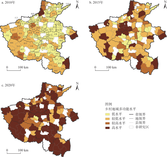
图3
乡村地域多功能空间分布格局
Fig. 3
Spatial distribution pattern of rural territorial multi-functions
河南省城乡融合发展的整体水平不断上升,且呈现“西南低—东北高”的不均衡空间特征(图4)。2010年城乡融合发展水平较高的有郑州市的新密市、中牟县等;2015年相较于前一节点,高水平区略有增加,自中部地区向东部、北部地区扩张;2020年河南省大多县域均处于较高水平区或高水平区,低水平区有三门峡市的卢氏县、信阳市的商城县等。从空间上看,河南省城乡融合发展的空间格局呈现“西南低—东北高”的空间格局。河南省西南部为豫西山区,且距离省会郑州等发展中心较远,因此城乡融合发展相对滞后。
图4
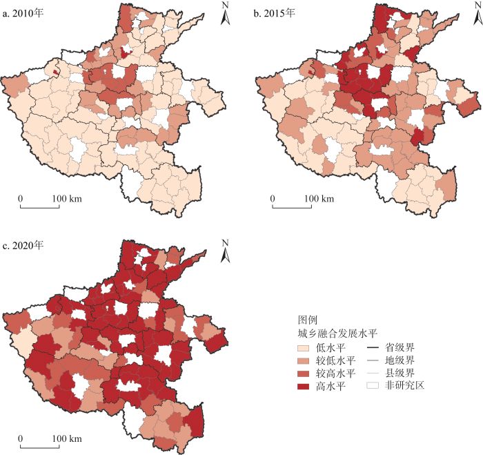
图4
城乡融合发展水平空间分布格局
Fig. 4
Spatial distribution pattern of urban-rural integrated development
3.2 乡村地域多功能空间关联网络的特征分析
3.2.1 整体网络特征
基于修正的引力模型构建河南省乡村地域多功能空间关联矩阵,并选取2010年、2015年和2020年绘制空间关联网络图(图5)。河南省乡村地域多功能的空间关联呈现出日趋复杂的网络结构形态,空间上表现出中部地区密集、外围逐层递减的圈层分异规律。2010年河南省乡村地域多功能空间关联的关系数有2148个,中部地区的联系程度较为紧密,东南及东北部地区的联系程度相对弱化;2015年空间关联的关系数增长至2180个,其中郑州市的中牟县、新郑市以及开封市的尉氏县等,关联关系数不断上升;2020年空间关联的关系数继续上升至2197个,东南及东北部地区的空间关联仍然较弱。从空间上看,乡村地域多功能空间关联网络表现出了极核式扩散的空间非均衡特征,且中部地区的空间关联紧密程度远高于周边地区。
图5
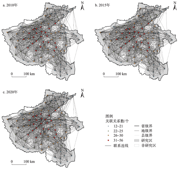
图5
乡村地域多功能的空间关联网络
Fig. 5
Spatial correlation network of rural territorial multi-functions
利用Ucinet软件计算得到2010—2020年河南省乡村地域多功能空间关联网络的网络整体特征指标(图6):网络密度整体呈上升态势,网络效率呈下降态势,网络关联度始终为1,网络等级度始终为0。
图6
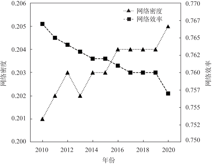
图6
乡村地域多功能空间关联网络的整体网络特征
Fig. 6
Overall network characteristics of spatial correlation network of rural territorial multi-functions
网络密度由0.201上升至0.205,网络关系数从2148个上升至2197个,空间关联的紧密程度不断升高,但是节点之间理论上最多可能有10712条溢出关系,说明乡村地域多功能区域协同性仍有较大提升空间。网络效率由0.767下降至0.758,说明网络结构愈发稳定。网络关联度始终为1表明没有一个地区独立存在,所有乡村地域之间均可借助网络形成空间关联关系。网络等级度始终为0说明乡村地域多功能空间关联网络的等级结构不明显,不同的乡村地域均对空间关联网络的形成和发展产生影响。
3.2.2 个体网络特征
通过探究河南省乡村地域多功能空间关联网络的个体网络特征,明晰不同地区的乡村地域在网络中的地位和角色(表3)。
表3 乡村地域多功能空间关联网络的网络中心性分析
Table 3
| 排名 | 度数中心度 | 中介中心度 | 接近中心度 | ||||||||
|---|---|---|---|---|---|---|---|---|---|---|---|
| 2010年 | 2015年 | 2020年 | 2010年 | 2015年 | 2020年 | 2010年 | 2015年 | 2020年 | |||
| 1 | 禹州市 | 禹州市 | 新郑市 | 禹州市 | 中牟县 | 中牟县 | 禹州市 | 禹州市 | 新郑市 | ||
| 2 | 新密市 | 新郑市 | 中牟县 | 新密市 | 禹州市 | 新郑市 | 新密市 | 新郑市 | 中牟县 | ||
| 3 | 新郑市 | 中牟县 | 禹州市 | 上蔡县 | 新郑市 | 禹州市 | 新郑市 | 中牟县 | 禹州市 | ||
| 4 | 汝州市 | 新密市 | 新密市 | 新郑市 | 新密市 | 商水县 | 长葛市 | 新密市 | 长葛市 | ||
| 5 | 巩义市 | 巩义市 | 汝州市 | 中牟县 | 商水县 | 上蔡县 | 临颍县 | 临颍县 | 新密市 | ||
| 6 | 偃师市 | 登封市 | 巩义市 | 封丘县 | 上蔡县 | 新密市 | 中牟县 | 襄城县 | 临颍县 | ||
| 7 | 中牟县 | 汝州市 | 长葛市 | 商水县 | 临颍县 | 临颍县 | 襄城县 | 长葛市 | 襄城县 | ||
| 8 | 荥阳市 | 荥阳市 | 襄城县 | 杞县 | 西华县 | 长葛市 | 西华县 | 西华县 | 商水县 | ||
| 9 | 登封市 | 叶县 | 商水县 | 临颍县 | 巩义市 | 兰考县 | 太康县 | 汝州市 | 叶县 | ||
| 10 | 上蔡县 | 鲁山县 | 登封市 | 长葛市 | 叶县 | 确山县 | 荥阳市 | 尉氏县 | 汝州市 | ||
注:篇幅限制,本表只展示前十名。
(1)度数中心度。禹州市、新密市、新郑市、中牟县、汝州市等超过均值且位居前列,在空间关联网络中处于核心地位,这些地区的乡村地域多功能水平较高,与其他地区的空间关联较为紧密。随着时间变化,上蔡县、偃师市等地区跌出前十名,被综合实力更强的长葛市、襄城县等替代。比如,长葛市近年来受到自身工业发展带动,其乡村地域多功能水平也大幅提升,成为区域内的核心节点。
(2)中介中心度。禹州市、中牟县、新密市、上蔡县、新郑市等超过均值且位居前列,是空间关联网络中的关键“中介”或“桥梁”,这些地区在空间关联网络中控制其他地区间资源要素交流的能力较强。从时间变化上看,封丘县、杞县等跌出前十名,逐渐被“战略地位”更好的兰考县、确山县等替代。比如,兰考县是河南省“一极两圈三层”中“半小时交通圈”的重要组成部分,距离新郑机场仅1小时。
(3)接近中心度。禹州市、新密市、中牟县、长葛市、新郑市等超过均值且位居前列,是空间关联网络中的“中心行动者”,这些地区能够直接与网络中其他地区快速建立联系。从时间变化上看,西华县、太康县等被“行动能力”更高的汝州市、商水县等替代。比如,汝州市被誉为“中国汝瓷之都”,而且辖区内温泉镇是省级的旅游产业集聚区,能够满足城乡居民对乡村文化、生态价值的追求,能够快速与其他地区进行资源要素交流。
南乐县、商城县和义马市等地区的各项网络指标均排名靠后,在乡村地域多功能空间关联网络中处于被动地位。这些地区的自身资源禀赋相对缺乏,其乡村地域功能水平也相对落后,并处在河南省东北和东南等偏远地区,导致其与周边乡村地域的功能联系相对较弱,在网络中处于边缘地位。
3.3 乡村地域多功能空间关联网络的结构特征对城乡融合发展影响的计量分析
本文所用到的是2010—2020年河南省104个县域的面板数据。在回归模型选择上,先后通过LM检验和Hausman检验最终确定使用固定效应模型。
在控制固定效应后,将网络结构特征中的度数中心度、中介中心度、接近中心度分别对城乡融合发展影响做了回归分析。由表4中的模型(1)和模型(4)可以看出无论是否加入控制变量,度数中心度对城乡融合发展的影响均显著为正,表明在乡村多功能空间关联网络中,“领导者”能够有效掌控网络中的多样化资源要素,并将其高效地转化为城乡融合发展的基础。在模型(2)和模型(5)中,无论是否加入控制变量,中介中心度对城乡融合发展的影响均显著为正,表明关键“桥梁”能够较好地控制资源要素的传导,分享到城乡要素流动的空间溢出效应,从而提升其城乡融合发展水平。在模型(3)和模型(6)中,虽然加入控制变量后,接近中心度的显著性有所下降,但仍然在10%的水平上显著为正,表明“中心行动者”具有较高的资源要素获取与利用能力,相较于“边缘行动者”更容易开展城乡融合活动。综上,随着乡村地域多功能空间关联网络的形成和发展,乡村地域多功能的城乡融合效应呈现网络非均衡性特征,个体网络中心性的提升对城乡融合发展具有显著的促进作用。
表4 网络结构特征对城乡融合发展影响的估计结果
Table 4
| 变量名称 | (1) | (2) | (3) | (4) | (5) | (6) |
|---|---|---|---|---|---|---|
| 度数中心度DC | 0.254*** | 0.176*** | ||||
| (0.034) | (0.033) | |||||
| 中介中心度BC | 0.582*** | 0.458*** | ||||
| (0.078) | (0.074) | |||||
| 接近中心度CC | 0.110*** | 0.063* | ||||
| (0.041) | (0.038) | |||||
| 公共财政支出EPF | 0.013*** | 0.013*** | 0.013*** | |||
| (0.002) | (0.002) | (0.002) | ||||
| 规模以上工业增加值IAV | 0.007*** | 0.007*** | 0.007*** | |||
| (0.001) | (0.001) | (0.001) | ||||
| 金融机构存贷款总额DIFI | 0.008*** | 0.008*** | 0.010*** | |||
| (0.002) | (0.002) | (0.002) | ||||
| 社会消费品零售总额RSCG | 0.015*** | 0.017*** | 0.017*** | |||
| (0.004) | (0.004) | (0.004) | ||||
| Observations | 1144 | 1144 | 1144 | 1144 | 1144 | 1144 |
| R-squared | 0.970 | 0.969 | 0.970 | 0.974 | 0.973 | 0.974 |
| 时间固定效应 | YES | YES | YES | YES | YES | YES |
| 地区固定效应 | YES | YES | YES | YES | YES | YES |
注:括号内数值表示标准误;*为p<0.1,**为p<0.05,***为p<0.01。
从控制变量来看,公共财政支出(EPF)、规模以上工业增加值(IAV)、金融机构存贷款总额(DIFI)、社会消费品零售总额(RSCG)均表现出显著的积极影响。公共财政支出有助于促进实体交通、虚拟网络等基础设施建设,对于拓宽城乡要素流动通道有重要支撑;工业发展水平越高,将有利于加强城市对乡村的剩余劳动力就业、生产资料供给的能力;金融发展水平越高,则有助于利用资金要素的流动带动相关要素在城乡之间高效配置;城乡居民的社会消费需求越高,越利于倒逼城乡产业转型升级,尤其是对于乡村的生态、文化等价值挖掘,可有效促进城乡融合发展。
4 结论与讨论
本文在厘清乡村地域多功能空间关联机制的基础上,阐释乡村地域多功能空间关联网络的结构特征对城乡融合发展的影响机制,并以河南省为案例区,借助社会网络分析法、面板回归模型等开展实证检验。主要研究发现如下:
(1)河南省乡村地域多功能的空间关联呈现出日趋复杂的网络结构形态,空间上表现出中部地区密集、外围逐层递减的圈层分异规律。
(2)从整体网络结构特征看,河南省乡村地域多功能空间关联网络的网络密度不断提高,网络稳定性逐步增强,但是网络的关联紧密程度仍有待提升。
(3)从个体网络结构特征看,新密市、新郑市和禹州市等处于网络的核心位置,而南乐县、商城县和义马市等在网络中处于边缘地位。
(4)乡村地域多功能空间关联网络的结构特征对城乡融合发展存在显著的影响,度数中心度、中介中心度、接近中心度的提升对城乡融合发展具有显著促进作用。
与已有研究重点关注乡村地域多功能的“空间分异”“系统演化”不同,本文探讨了乡村地域多功能的空间关联机制,从网络化视角揭示了乡村地域多功能的空间交互作用,推动乡村功能研究由侧重“相对位置”“地理距离”的中心地思维,向关注“非层级”“水平化”的网络化思维转变。而且,与以往网络外部性研究主要关注经济绩效不同,本文阐释了乡村地域多功能空间关联网络结构特征对城乡融合发展的影响机制,有助于从“城乡关系”的视角丰富网络绩效研究,同时对理解城乡融合发展的空间异质性也有一定理论意义。
参考文献
迈向2035年的中国乡村: 愿景、挑战与策略
China's rural areas toward 2035: Vision, challenges and strategies
城乡融合发展机理与演进规律的理论解析
DOI:10.11821/dlxb202204001
[本文引用: 1]

城市与乡村始终是一个不可分割的有机融合体,高质量的新型城镇化过程就是城乡融合发展与乡村振兴过程。“城市病”因乡村病而生,“乡村病”也因城市病而生,“城市病”与“乡村病”同病相连,互为病因,复合叠加形成“城乡病”,根治“城市病”必须通过乡村振兴,根治“乡村病”也必须通过新型城镇化。本文在对国内外城乡融合发展研究综述的基础上,从理论层面分析了城乡病理病根及对立格局,解析了城乡融合发展的主控要素、驱动机制、城乡融合发展的规律性和持续性,构建城乡融合发展测度试验系统,提出了城乡多融合发展的三角模式,验证了中国城乡融合发展正处在城镇化后期城多乡少的高度融合阶段,未来将迈入城镇化终期城多乡少的深度融合阶段。从政策层面分析了中华人民共和国成立以来国家有关城乡发展政策的演进路径,总体经历了从城乡二元发展、城乡协调发展、城乡统筹发展、到城乡一体化发展、再到城乡融合发展的政策演进过程,这些政策对推动新型城镇化和乡村振兴发挥了重要指导作用。从路径层面建议合并召开中央城乡工作会议,合并编制《国家城乡融合发展规划》,实施城乡深度融合发展战略,把新型城镇化与乡村振兴同时作为解决城乡病、提升城乡发展质量的两种不同手段,创新城乡融合发展理论与方法,构建评估体系定量评判城乡融合发展程度,建设美丽城市和美丽乡村。推动新型城镇化与乡村振兴向高度同步化、深度融合化和共荣化方向发展,同步提升城市发展质量和乡村发展质量,同步实现城市现代化和乡村现代化。
Theoretical analysis on the mechanism and evolution law of urban-rural integration development
DOI:10.11821/dlxb202204001
[本文引用: 1]
Urban and rural areas are always an inseparable organic integration, and the high-quality new urbanization is the process of urban-rural integration and rural revitalization. "urban disease" and "rural disease" are connected with each other, and are the causes of each other, which are known as "urban and rural diseases". The radical cure of "urban disease" and "rural disease" requires rural revitalization and new urbanization. Based on the review of the research on urban-rural integration development at home and abroad, this study analyzes the pathological roots and opposition pattern of urban and rural areas from the theoretical level, explores the main controlling factors, driving mechanism, sustainability and four-stage regularity of urban-rural integration development, constructs the measurement test system of urban-rural integration development, and puts forward the triangular model of urban-rural multi-integration development. It is known that the urban-rural integration development in China is in the high integration stage of more towns and less villages in the late urbanization, and will enter the deep integration stage of more towns and less villages, namely the final stage of urbanization. This study explores the policy evolution path of urban-rural integration development in China since the founding of the People's Republic of China in 1949. China has generally experienced the policy evolution process from urban-rural coordinated development to the integration of urban-rural development and then to urban-rural integration development, and played an important guiding role in promoting new urbanization and rural revitalization. From the path level, it is suggested that the Central Urban and Rural Work Conference should be jointly convened, the National Urban-Rural Integration Development Plan should be jointly compiled, and the strategy of deep integration of urban-rural development should be implemented. The new urbanization and rural revitalization should be used as two different means to solve urban and rural diseases and improve the quality of urban and rural development. The theory and method of urban-rural integration development should be innovated, and the evaluation system should be constructed to quantitatively evaluate the depth of urban-rural integration development and build beautiful cities and beautiful villages. We should promote the development of new urbanization and rural revitalization in the direction of high synchronization, deep integration and co-prosperity, as well as improve the quality of urban and rural development and realize urban and rural modernization in a comprehensive way.
中国乡村振兴与乡村功能优化转型
DOI:10.13249/j.cnki.sgs.2021.12.009
[本文引用: 1]
基于乡村功能与乡村振兴之间的双向互动关系,建立基于“三生”空间系统的乡村功能与乡村振兴之间的逻辑关系,探讨乡村功能优化转型的方向,并提出乡村功能优化转型的策略。乡村功能的优化转型,可以为乡村振兴战略提供动力和活力;乡村振兴战略的实施,可以为乡村功能优化转型提供方向引导和政策支持。研究表明:① 生产功能优化转型可推动乡村产业振兴;生活功能、文化传承功能优化可推动乡村文化振兴;生态功能强化可推动乡村生态振兴;组织功能复兴可推动乡村组织振兴;乡村整体功能优化需要乡村人才振兴。② 乡村振兴必须优化乡村“三生”空间布局,按照不同类型乡村发展特点,分类推进乡村发展;乡村功能优化转型的终极价值是实现“人与自然生命共同体”“人类命运共同体”目标。③ 以乡村产业新业态带动乡村功能优化转型过程中,要有效发挥乡村振兴政策和制度的支撑作用。
Rural revitalization and rural functional optimization and transformation in China
DOI:10.13249/j.cnki.sgs.2021.12.009
[本文引用: 1]
Based on the two-way interactive relationship between rural function and rural revitalization, this article establishes the logical relationship between them, which based on the spatial system of “Production-Living-Ecological Space”. It also discusses the direction of the optimization and transformation of rural function and puts forward the strategy for it. The optimization and transformation of rural functions can provide power and vitality for the strategy of rural revitalization, and the strategy implementation can provide direction and policy support for the optimization and transformation of rural function. The research shows that: 1) The optimization and transformation of production function can promote the revitalization of rural industry. The optimization of the function of living and cultural inheritance can promote the revitalization of rural culture. The reinforcement of ecological function can promote the revitalization of rural ecology. The revival of organizational function can promote the revitalization of rural organizations. While the optimization of the overall rural function needs the revitalization of rural talents. 2) Rural revitalization must optimize the spatial layout of “Production-Living-Ecological Space”. We should boast rural development according to the developing features of different types of countryside. The ultimate significance of the optimization and transformation of rural function is to achieve the “community of human and natural life” and “community of human destiny”. 3) In the process of optimizing and transforming rural function driven by new forms of rural industries, we should effectively excert the important supporting role of rural revitalization policies and rural revitalization systems to rural development.
基于CiteSpace中国乡村功能研究的知识图谱分析
Knowledge structure of rural function in China: An analysis based on CiteSpace map
DOI:10.1080/00130095.1961.11729540 URL [本文引用: 1]
乡村地域多功能的内涵及其政策启示
Connotations of rural regional multifuction and its policy implications in China
Agricultural multifunctionality in the WTO-legitimate non-trade concern or disguised protectionism
DOI:10.1016/S0743-0167(01)00031-6 URL [本文引用: 1]
Impulses towards a multifunctional transition in rural Australia: Gaps in the research agenda
DOI:10.1016/j.jrurstud.2005.08.006 URL [本文引用: 1]
乡村地域多功能的研究进展与展望
Progress and prospect in the study of rural region multifunctions
基于多功能理论的中国乡村发展多元化探讨: 超越“现代化”发展范式
DOI:10.11821/dlxb201502007
[本文引用: 2]
传统的乡村现代化发展范式和地理学关于乡村的区域差异研究之间存在缝隙,不足以为快速演化分异的乡村地域发展提供直接理论支撑。本文引入西方近20年来逐渐兴起的多功能农业与多功能乡村理论,从新的视角观察思考中国乡村多元化发展的目标、路径及对策。首先从经济、社会和环境三个方面反思中国乡村现代化的基本历程与得失,以及西方国家乡村现代化产生的问题,指出传统的农业农村现代化发展在很大程度是以牺牲乡村环境和乡村社会机理脆弱化为代价的,也造成了乡村经济对外部支持的过度依赖,仅仅强调“现代化”发展范式显然是不够的;然后简要介绍了国外多功能农业与多功能乡村理论;在此基础上,从功能角度提出中国农业农村发展的多元目标,推演探讨农业农村发展的区域差异化路径及对策。
Diversified agriculture and rural development in China based on multifunction theory: Beyond modernization paradigm
DOI:10.11821/dlxb201502007
[本文引用: 2]
There is a big gap between general rural modernization paradigm and huge empirical rural geography studies. This gap results in impotent development strategies on regionally differentiated countryside. Based on multifunctional agriculture theory and multifunctional rural theory which emerged in Western World as a new paradigm, this paper discusses the multiple objectives, differentiated pathways and policies of agriculture and rural development in China. Firstly, this paper reflects the problems and challenges caused by modernization paradigm in rural China on economic, social, and environmental aspects, as well as that of western developed countries. It can be concluded that conventional agricultural and rural modernization is developed largely at the expense of rural environment, social fabric and economic viabilities. Obviously, "modernization development paradigm" alone is not enough for healthy agricultural and rural development in such booming economy as China. A better paradigm should be developed which takes economic development, social justice and environmental sustainability into account at the same time. After a brief review of multifunctional agriculture theory and multifunctional rural theory overseas, the multiple objectives of agriculture and rural development in China are put forward. These multiple objectives, however, should not and could not be a burden on rural space indiscriminatingly due to the enormous differentiation of natural and socio-economic conditions. Thus, the final but main part of this paper envisions the differentiated pathways and policy portfolios of agricultural and rural development in China from the perspective of territorial division.
中国新时代城乡融合与乡村振兴
DOI:10.11821/dlxb201804004
[本文引用: 1]
城市与乡村是一个有机体,只有二者可持续发展,才能相互支撑。依据人地关系地域系统学说,城乡融合系统、乡村地域系统是全新认知和理解城乡关系的理论依据。针对日益严峻的“乡村病”问题,全面实施乡村振兴,既是推进城乡融合与乡村持续发展的重大战略,也是破解“三农”问题,决胜全面建成小康社会的必然要求。本文探讨了新时代城乡融合与乡村振兴的基础理论,剖析了乡村发展面临的主要问题,提出了问题导向的中国城乡融合与乡村振兴科学途径及研究前沿领域。结果表明:① 城乡融合与乡村振兴的对象是一个乡村地域多体系统,包括城乡融合体、乡村综合体、村镇有机体、居业协同体,乡村振兴重在推进城乡融合系统优化重构,加快建设城乡基础网、乡村发展区、村镇空间场、乡村振兴极等所构成的多级目标体系。② 中国“三农”问题本质上是一个乡村地域系统可持续发展问题,当前乡村发展正面临主要农业生产要素高速非农化、农村社会主体过快老弱化、村庄建设用地日益空废化、农村水土环境严重污损化和乡村贫困片区深度贫困化等“五化”难题。③ 乡村是经济社会发展的重要基础,城乡融合与乡村振兴战略相辅相成,乡村振兴应致力于创建城乡融合体制机制,推进乡村极化发展,按照产业兴旺、生态宜居、乡风文明、治理有效、生活富裕的要求,构建乡村地域系统转型—重构—创新发展综合体系。④ 乡村振兴地理学研究应着眼于乡村地域系统的复杂性、综合性、动态性,探究以根治“乡村病”为导向的新型村镇建设方案、模式和科学途径,为实现新时代中国乡村振兴战略提供理论参考。
Research on the urban-rural integration and rural revitalization in the New Era in China
DOI:10.11821/dlxb201804004
[本文引用: 1]
Cities and villages are components of a specific organism. Only the sustainable development of two parts can support the prosperous development as a whole. According to the theory of man-earth areal system, urban-rural integrated system and rural regional system are the theoretical bases for entirely recognizing and understanding urban-rural relationship. To handle the increasingly severe problems of "rural disease" in rapid urbanization, accelerating rural revitalization in an all-round way is not only a major strategic plan for promoting the urban-rural integration and rural sustainable development, but also a necessary requirement for solving the issues related to agriculture, rural areas, and rural people in the new era and securing a decisive victory in building a moderately prosperous society in all respects. This study explores the basic theories of urban-rural integration and rural revitalization and analyzes the main problems and causes of rural development in the new era, proposing problem-oriented scientific approaches and frontier research fields of urban-rural integration and rural revitalization in China. Results show that the objects of urban-rural integration and rural revitalization is a regional multi-body system, which mainly includes urban-rural integration, rural complex, village-town organism, and housing-industry symbiosis. Rural revitalization focuses on promoting the reconstruction of urban-rural integration system and constructs a multi-level goal system including urban-rural infrastructure networks, zones of rural development, fields of village-town space and poles of rural revitalization. Currently, the rural development is facing the five problems: high-speed non-agricultural transformation of agriculture production factors, over-fast aging and weakening of rural subjects, increasingly hollowing and abandoning of rural construction land, severe fouling of rural soil and water environment and deep pauperization of rural poverty-stricken areas. The countryside is an important basis for the socioeconomic development in China, and the strategies of urban-rural integration and rural revitalization are complementary. The rural revitalization focuses on establishing the institutional mechanism for integrated urban-rural development and constructs the comprehensive development system of rural regional system, which includes transformation, reconstruction and innovation in accordance with the requirements of thriving businesses, pleasant living environments, social etiquette and civility, effective governance, and prosperity. Geographical research on rural revitalization should focus on the complexity and dynamics of rural regional system and explore new schemes, models and scientific approaches for the construction of villages and towns, which are guided by radical cure of "rural disease", implement the strategy of rural revitalization polarization, construct the evaluation index system and planning system of rural revitalization, thus providing advanced theoretical references for realizing the revitalization of China's rural areas in the new era.
湖南省传统农区乡村功能时空演变及影响因素研究
DOI:10.13249/j.cnki.sgs.2021.12.010
[本文引用: 2]
乡村是城市功能扩散与转移的重要承接地,乡村功能的时空演变及影响因素分析对实现城乡统筹发展与可持续发展具有重要意义。综合运用熵值法、冷热点分析和地理探测器等方法,以湖南省102个县市为研究对象,对湖南省乡村功能的时空演变、空间分异及其影响因素进行研究。结果表明:① 1997―2017年县域乡村生产和生活功能整体上呈现出上升的发展态势,而乡村生态功能整体上呈减弱的趋势。② 1997―2017年湖南省乡村功能热点区由长株潭地区向外扩张,而冷点区呈先收缩后扩张的发展态势;20 a间,在长株潭地区形成稳定的热点区,在湘西地区形成稳定的冷点区。③ 湖南省乡村功能空间分异是农业现代化、乡村就业主体、县域经济基础、城镇化、工业化等综合作用的结果,其影响力大小与方向存在显著的差异性,其中农业现代化水平、乡村就业主体对湖南省及5个地区乡村功能空间分异有重要的驱动作用。
The spatial-temporal evolution and influencing factors of rural functions in traditional agricultural areas in Hunan province
DOI:10.13249/j.cnki.sgs.2021.12.010
[本文引用: 2]
Rural function refers to the sum of various services provided by the village to meet the various needs of rural residents, involving ecological, economic, social, cultural and other aspects. China is in a critical period of urbanization development. The expansion of urban and rural construction land has restricted rural production space, fragmented living space, and unbalanced ecological space. However, the development of economy and technology and the proposal of rural revitalization strategies have prompted the reintegration of various elements of the rural regional system. The village has entered a period of rapid transformation. Under the effects of both rural revitalization and urbanization, important changes have taken place in rural employment structure, consumption patterns, and urban-rural relations. Rural functions have gradually extended from primitive residential and agricultural production functions to industrial production functions, life support functions, and eco-tourism. Traditional agricultural areas are the main producing areas of agricultural products and agricultural and sideline products, and shoulder the important task of national food security. The occupation of cultivated land by industrialization and urbanization has affected the development of traditional agricultural areas in the country. The priority development of China’s economic efficiency has neglected the protection of rural culture and ecology, which has caused serious degradation of rural traditional functions. The village is an important bearing of the diffusion and transfer of urban functions. The analysis of the spatiotemporal evolution of rural functions and its influencing factors is of great significance for the realization of urban and rural integrated development and sustainable development. A comprehensive application of the entropy method, cold and hot spot analysis, and geo-detector methods, taking 102 counties and cities in Hunan Province as the study area, the spatial-temporal evolution, spatial differentiation, and driving forces of rural functions in Hunan Province are studied by the paper. The results show that: 1) On the whole, from 1997 to 2017, the production and living functions of rural areas in the county area showed an upward trend, while changes in rural ecological functions showed a weakening development trend. 2) From 1997 to 2017, Hunan’s rural functional hotspot area expanded from Changzhutan area to the periphery, while the cold spot area expanded first and then expanded. In these 20 years, a stable hotspot area was formed in Changzhutan area, while On the west side, a stable cold spot area is formed. 3) The spatial differentiation of rural functions in Hunan Province is the result of the combined effect of county background factors and external driving factors, and their roles are significantly different in direction and direction. The two indicators of agricultural modernization level and the main body of rural employment have a significant impact on rural functions.
中国县域乡村地域多功能格局及影响因素识别
DOI:10.18306/dlkxjz.2019.09.005
[本文引用: 4]
论文以中国大陆县域为研究单元,构建乡村地域多功能评价指标体系,利用熵权法、半变异函数和地理探测器等模型,对2000—2015年中国乡村多功能指数进行综合测评,揭示中国县域乡村地域多功能的空间分异特征,定量识别乡村地域多功能空间分异的影响因素。研究结果表明:① 中国乡村地域多功能在空间上呈现出平原、东部沿海等地区高值集聚,高原、山地等地区低值集聚,各县域乡村地域多功能整体呈现出逐渐提升态势;② 经济发展功能和社会保障功能对乡村地域多功能的贡献率逐渐增大,农业生产功能和生态保育功能对乡村地域多功能的贡献率逐渐减小;③ 2000—2015年,中国大陆范围内县域乡村地域多功能空间自相关范围和强度总体呈现减小的趋势,随机性因子成为乡村地域多功能空间分异的主要驱动力;④ 县域经济整体发展水平和财政收入是影响乡村地域多功能空间分异的主导因素;各影响因素之间的两两交互作用会增强乡村地域多功能的空间分异;社会环境因素对乡村地域多功能空间分异的影响程度逐渐上升,自然环境因素的影响程度逐渐下降。
Spatial pattern and influencing factors of rural multifunctionality at county level in China
DOI:10.18306/dlkxjz.2019.09.005
[本文引用: 4]
To reveal the spatial differentiation characteristics of rural multifunctionality in Chinese county areas and quantitatively identify the influencing factors of spatial differentiation of rural multifunctionality, this study comprehensively evaluated rural multifunctionality at the county level in China from 2000 to 2015 by constructing an evaluation index system, using entropy weight method, semi-variance function, and geodetector method. The main results are as follows: 1) The spatial distribution of rural multifunctionality was uneven. High-value regions of rural multifunctionality were concentrated in the plain areas and the eastern coasts of China. Low-value regions were concentrated on the plateaus and in the mountain regions. Rural multifunctionality presents a gradual upward temporal trend as a whole. 2) The contribution rate of economic development function and social security function to rural multifunctionality gradually increased, and the contribution rate of agricultural production function and ecological conservation function to rural multifunctionality gradually decreased. 3) From 2000 to 2015, the range and intensity of spatial auto-correlation of rural multifunctionality gradually decreased at the county level in China. Random factors became the driving forces of spatial differentiation of rural multifunctionality. 4) Economic development and fiscal revenue of counties were the main factors that affect the spatial differentiation of rural multifunctionality. The interaction of different influencing factors enhanced the spatial differentiation of rural multifunctionality. The degree of influence of social factors was gradually rising and the degree of influence of natural factors was gradually decreasing over time.
基于县域尺度乡村地域多功能空间分异特征及类型划分: 以湖南省为例
Multifunctional spatial characteristics of rural areas and their type identification based on county scale: A case of Hunan province
乡村地域多功能空间分异特征及类型识别: 以辽宁省78个区县为例
DOI:10.11821/dlyj020170647
[本文引用: 1]
以具有国家粮食基地和老工业基地的经济功能与特征的辽宁省为例,通过构建乡村地域多功能评价指标体系,采用ArcGIS自然间断点分级法和全局空间自相关分析农业生产、非农生产、居住生活和生态保障四类功能的空间格局特征,采用Spearman等级相关系数定量分析功能间交互作用,识别各区县优势功能类型,并提出未来发展的政策建议。结果表明:① 从省域层面看,乡村地域功能空间格局的空间差异性和空间集聚特征显著;② 根据乡村地域功能间的相关关系和功能间的互动实际,得出各功能间的交互作用类型,从而为功能调控提供指导;③ 基于功能状态和功能间的交互作用,将辽宁省78个区县划分为8种乡村地域功能类型,并根据类型提出科学谋划辽宁乡村未来发展的初步建议,为促进乡村转型与城乡统筹提供参考。
Spatial differentiation and type identification of rural territorial multi-functions in Liaoning province
DOI:10.11821/dlyj020170647
[本文引用: 1]
In the new era, China is promoting integrated urban and rural areas. Rural territory is in the process of transformation, development and reconstruction. The features of rural territorial function diversification and multi-functionality have become more and more obvious. This paper takes Liaoning province, which is one of the national grain producing bases and old industrial bases in China, as the research area. It constructs an evaluation index system of rural territorial multifunctions from the following four aspects: agricultural production function, non-agricultural production function, dwelling and living function, and ecological service function. Jenks and Global Spatial Autocorrelation are used to explore the spatial pattern and spatial correlation of rural territorial functions. The Spearman's rho is used to analyze the interactions among rural territorial functions. This paper identifies the dominant function types of different counties in Liaoning province, and puts forward policy recommendations for their future development. The results of the study are reflected in the following three aspects: (1) The spatial distribution of rural territorial functions has obvious spatial heterogeneity and spatial agglomeration characteristics in Liaoning province. The highest and higher values of agricultural production function concentrate in the Liaohe River Plain. Non-agricultural production function decreases from the core urban areas, the highest, and higher values areas to the outside. The highest, higher, and middle values of dwelling and living function concentrate in municipal districts. The highest and higher values of ecological service function are observed in the mountainous areas. (2) According to the correlation among rural territorial functions and the actual interaction among functions, the types of interaction among functions have been clearly identified, which can provide guidance for the regulation of functions. (3) Based on the status and interactions of different functions, eight types of rural territorial functions have been identified. According to the types, preliminary proposals are put forward for the future development of rural areas in Liaoning province, which would provide references for the promotion of the rural transformation and the balanced urban and rural development.
The multifunctional transition in Australia's Tropical Savannas: The emergence of consumption, protection and indigenous values
DOI:10.1111/j.1745-5871.2009.00629.x URL [本文引用: 1]
From 'weak' to 'strong' multifunctionality: Conceptualising farm-level multifunctional transitional pathways
DOI:10.1016/j.jrurstud.2007.12.010 URL [本文引用: 1]
New roles for farming in a differentiated countryside: The portuguese example
DOI:10.1007/s10113-008-0062-8 URL [本文引用: 1]
基于多源数据的乡村功能空间特征及其权衡协同关系度量
DOI:10.11821/dlyj020201140
[本文引用: 2]
本研究基于土地利用、兴趣点、社会经济统计等数据,从乡镇尺度揭示了北京生态涵养区经济发展、农产品生产、社会保障、生态服务、旅游休闲以及综合功能的空间特征,并运用Spearman秩相关分析、生产可能性边界(PPF)、权衡强度指数等定量探讨了多功能间的权衡-协同关系及其权衡程度。结果表明:① 经济发展、社会保障和休闲旅游功能的空间格局相似;生态服务功能与经济发展、社会保障和农产品生产功能的空间格局基本相逆。② 经济发展与农产品生产/社会保障功能为显著协同关系;经济发展/农产品生产/社会保障与生态服务功能为显著权衡关系。③ 按照“‘权衡强度越小,功能间共生发展’‘权衡强度越大,最多发展一种功能’”的思路,以追求乡村功能组合的综合效益最大化为目标,将生态涵养区划分为I(4种功能共生)、II(3种功能共生)、III(2种功能共生)和IV(单一功能发展)4种类型区。研究结果将为区域乡村振兴规划编制提供参考,为乡村功能协同发展路径设计提供技术支撑。
Spatial differentiation characteristics and trade-off/synergy relationships of rural multi-functions based on multi-source data
DOI:10.11821/dlyj020201140
[本文引用: 2]
Based on land use, point of interest, socio-economic statistics and other data, this study constructs an evaluation system of rural function from five dimensions of economic development, agricultural product production, social security, ecological services and tourism and leisure, and reveals the spatial characteristics of the five functions above and their comprehensive functions of the ecological conservation area from the township scale. By means of Spearman rank correlation analysis, production possibility frontier (PPF) and trade-off intensity index and so on, the trade-off coordination relationship and the degree of trade-off between rural functions are quantitatively discussed. The results show that: (1) the spatial patterns of economic development, social security and leisure tourism functions are similar; on the contrary, the functions of economic development, social security and agricultural products production in towns with strong ecological service function are often weak. (2) There is a significant synergy relationship between economic development and agricultural production / social security function, and a significant trade-off relationship between economic development / agricultural production / social security and ecological service function. And the trade-off intensity is economic development - ecological services > social security - ecological services > agricultural production - ecological services. When it comes to the PPF curve, we can conclude that the trade-off between economic development / agricultural product production and ecological service function is similar. That is to say, the trade-off between which will be weakened while sustainably developing the ecological services. The trade-off between social security and ecological services will intensify with the continuous investment of ecological services. The synergetic effect of economic development on agricultural production (social security) function will slow down with the development of economic function. (3) According to the idea of "the less the trade-off intensity is, the symbiotic development among functions" and "the greater the trade-off intensity, the most one function can be developed". In order to maximize the comprehensive income of rural functional combination, the ecological conservation area will be divided into four types of development areas: I (four types of functional symbiosis), II (three kinds of functional symbiosis), III (two kinds of functional symbiosis) and IV (single function development). The research results will be helpful for regional rural revitalization and development planning, and provide technical support for scientific design of rural function collaborative development path.
城乡融合发展、逆城镇化趋势与乡村功能演变: 来自大城市郊区城乡关系变化的观察
Urban-rural integration, counter-urbanization and function evolution of countryside: Observation on changes in urban-rural relations in suburbs of metropolis
北京市城乡转型与乡村地域功能的时序特征及其关联性
Temporal characteristics and correlation between rural-urban transition and rural regional functions in Beijing
长江中游城市群三生功能的空间关联性
Spatial correlation of the productive-ecological-living function of urban agglomeration in the middle reaches of the Yangtze River
京津冀城市群城市功能互动格局与治理策略
DOI:10.11821/dlxb202206006
[本文引用: 1]
京津冀协同发展和北京市非首都功能疏解政策实施状况是当前学术界和政府关注的热点。城市功能的分布和互动格局是刻画城市群协同发展和治理策略成效的重要内容。本文在阐述城市群内城市功能之间互动原理基础上,引入偏离—份额分析模型、改进土地生态位模型、扩展引力模型和GIS技术,耦合构建了新的城市功能互动模型。以京津冀城市群为研究对象,基于2010年、2016年、2019年3期POI大数据提取不同类别城市功能区,从时空两个维度揭示京津冀城市群功能的互动格局特征,分析协同发展和北京市非首都功能疏解政策实施状况,并有针对性地提出了治理策略。结论显示:① 2010—2019年间城市群建成区城市功能区总面积增加1.5倍,其中混合功能区增长最快,增加1.7倍;② 北京市工业功能、商业功能正在稳步疏解,但是居住功能、科教文化功能、公共服务功能仍在聚集与强化;③ 廊坊市、唐山市、天津市、保定市等中部城市在非首都功能疏解中发挥了“二传手”作用,成为功能互动的主要驱动城市;④ 石家庄市吸纳的疏解功能主要来源于天津市和廊坊市,具有接力特征;⑤ 京津冀城市群城市功能疏解在治理策略上需要关注功能互动格局演化趋势来进行精准施策。上述结论表明本文构建的城市功能互动模型可以较好地揭示和解释京津冀城市群城市功能互动格局的变化特征。
Big-data driven functional interaction patterns and governance strategy for Beijing-Tianjin-Hebei Region
DOI:10.11821/dlxb202206006
[本文引用: 1]
The coordinated development of the Beijing-Tianjin-Hebei (BTH) region and the implementation of the policy of relieving non-capital functions from Beijing are one of hot topics in current academia and the government. The distribution and interaction patterns of urban functions are an important aspect to depict the performance of the coordinated development and governance strategies of the BTH urban agglomeration. Based on the interaction principle of urban functional zones in the BTH region, we introduced the shift-share analysis model, revised land ecological niche model, and coupled a new interactive model by expanding the gravity model for urban functional interaction patterns, supported by GIS technique. We consider the POI as a commonly used big data to analyze urban problems and characteristics, this study takes the BTH urban agglomeration as the study area and uses three periods (2010, 2016, 2019) of POI datasets to identify urban functional zones. Then we apply the new interactive model to reveal the characteristics of the functional interaction patterns from space and time dimensions. Meanwhile, we analyze and evaluate the coordinated development and implementation of the policy of relieving non-capital functions from Beijing, and come up with some suggestions. Our findings are: (1) the total area of urban functional areas increased 1.5 times over the past decade, and the mixed functional areas are the fastest-growing urban functional zone (1.7 times). (2) The industrial and commercial functional zones of Beijing had been dispersing steadily, but the residential, scientific, educational and cultural, and public service functional zones were still aggregated. (3) Langfang, Tangshan, Tianjin, and Baoding, which are located in the center of BTH region, act as "middlemen" in the redistribution process of the relieving policy. They become main cities to drive functional interaction. (4) Shijiazhuang mainly received the functional zones from Tianjin and Langfang, which shows the relay characteristics. (5) The government's decision-making for redistribution of urban functional zones in the BTH region should consider the evolution trend of functional interaction patterns among cities so as to take targeted governance measures. Our findings indicate that the urban functional interactive model could better explain and reveal changing characteristics of the functional interaction patterns in the study region.
长三角城市网络外部性的空间异质性
DOI:10.11821/dlyj020220172
[本文引用: 1]
城市网络中是否存在“低端锁定”现象,低等级城市能否从网络中获益,高等级城市是否发挥了辐射带动作用,这些问题关系城市群发展的战略导向,当前仍缺乏深入论证。城市网络外部性是指城市因联系而得到的效益,为回答上述问题提供了理论依据,已成为城市网络研究的新热点。但现有研究主要关注网络外部性的整体特征,忽视区域内城市间的网络外部性差异。本文使用地理加权回归模型将网络外部性测度精确到每个城市,揭示网络外部性的空间异质性特征。研究以长三角地区41个城市为研究对象,按城市汇总企业之间相互投资规模构建城市网络,分析网络联系对城市发展水平的影响,证实了长三角地区存在网络外部性。研究发现:① 虽然网络外部性未成为主导,但嵌入城市网络已经对江浙沪城市发展起到了积极影响。② 网络外部性的地域差异较大,江苏省城市的网络外部性普遍强于浙江省,安徽省的网络外部性不强,城市发展仍主要由人、土地和资本的本地集聚决定。③ 长三角地区的网络外部性主要是在上海的辐射带动作用下形成的,3个省会城市南京、合肥、杭州对周边城市的辐射带动作用有限。④ 低等级城市虽未从网络中获得明显的效益,但也未被“低端锁定”,高等级城市没有在周边形成“集聚阴影”。本文希望能有助于完善城市网络外部性理论,为区域网络化发展提供理论支撑。
Spatial heterogeneity of urban network externalities in the Yangtze River Delta
DOI:10.11821/dlyj020220172
[本文引用: 1]
Is there is a phenomenon of "low-end locking" in the urban network? Can low-grade cities benefit from the urban network? Have high-grade cities played a leading role in the urban network? These issues are related to the strategic orientation of the development of urban agglomeration, which is still lack of in-depth research. Urban network externalities refer to cities benefited by connecting with other cities, which provides a theory for answering the above questions and has become a new hotspot in urban network research. Existing studies focus on the overall characteristics of urban network externalities, but ignore the differences of urban network externalities between cities. In this paper geographical weighted regression model is used to accurately measure the urban network externalities to each city and reveal the spatial heterogeneity of urban network externalities. Taking 41 cities in the Yangtze River Delta region as case studies, we construct the urban network according to the scale of mutual investment of enterprises between cities. Then we analyze the influence of network connection on urban development, which proves that there exist urban network externalities in the study area. The results are as follows: (1) Although the urban network externalities are not dominant, joining urban networks has played a positive role in the urban development of Jiangsu, Zhejiang and Shanghai. (2) There are great regional differences in urban network externalities. The urban network externalities of cities in Jiangsu are generally stronger than those of Zhejiang, while those in Anhui are not strong. Urban development is still mainly determined by the local agglomeration of people, land and capital. (3) The urban network externalities in the Yangtze River Delta are formed mainly under the influence of Shanghai, but the influence of the three provincial capitals — Nanjing, Hefei and Hangzhou — is limited. (4) Although low-grade cities have not benefited from the network, they are not "low-end locking" either. High-grade cities do not form a "cluster shadow" around them. This paper hopes to improve the theory of urban network externalities and provide theoretical support for regional network development.
基于城市功能网络视角的城市联系研究: 以珠江三角洲为例
DOI:10.13249/j.cnki.sgs.2015.03.306
[本文引用: 1]
以城市功能的演进历程为城市联系研究的新视角,构建了城市联系的城市功能网络分析框架。其中,城市功能网络由功能要素、联系通道和作用载体三部分组成,是城市功能在多元、差异和互补的基础上通过有形或无形的联系通道,以实体或虚拟的空间"流"为作用载体形成的城市功能空间网络化结构。基于城市功能网络的概念内涵,以珠江三角洲城市功能网络的演化历程为实例,演示了该地区城市联系的演化历程和空间特征,探索了城市联系的城市功能网络分析视角。
City linkage based on city functional network: Taking Zhujiang River Delta as an example
DOI:10.13249/j.cnki.sgs.2015.03.306
[本文引用: 1]
As an important property of city, city functions in different periods differ in forms, intensity and spatial characteristics from the preindustrial age to the postindustrial age. City function experienced from a single and simple function to various, messy and homogeneous functions and then to the diversified different and complementary networked evolution process. This article tries to open a new view angle of city linkage research based on the evolution of city function by constructing an analytical structure of city functional network. The city functional network in the postindustrial period consists of three components of function elements, linkage channel and role carrier. On the basis of diverse, different and complementary city function and through the tangible or intangible linkage channel and taking the entity or virtual spatial flow as the role carrier, forms spatial network structure of city functional network was formed. Based on the evolution process of city function and the concept and connotation of city function network, the article took the evolution of city function network in the Zhujiang River Delta as an example, and reconstructed the history and space features of city linkage in the region and finally constructed a new analytical perspective of city function network on city linkage researches.
基于功能网络的珠三角区域城市联系研究
A city linkage study on Zhujiang River Delta Region: From a function network view
中国经济高质量发展的空间关联网络及其作用机制
DOI:10.11821/dlxb202208006
[本文引用: 1]
高质量发展是中国“十四五”乃至更长时期经济社会发展的主题,也是适应社会主要矛盾变化的基本要求,更是建设社会主义现代化国家的关键路径和遵循经济实践规律的根本所在。本文从创新、协调、绿色、开放、共享5个维度构建经济高质量发展的评价指标体系,测度了2011—2018年中国31个省(自治区、直辖市)的经济高质量发展水平,在此基础上运用社会网络分析(SNA)和二次指派程序(QAP)分别对经济高质量发展的关联网络结构特征和经济高质量发展差异的作用机制进行分析。研究发现:① 空间关联网络的关联度一直为1,且网络密度稳定在0.2~0.26之间,省际经济高质量发展的空间关联网络通达性较强且存在多重叠加现象和一定的等级性,但关联紧密程度有待提高,各网络指标保持相对稳定。② 省际经济高质量发展的空间关联网络可以分为4个板块,其中以西部省份为主的“净溢出”板块获益最小;以中部省份为主的“经纪人”板块起着“中介”和“桥梁”的作用;以环渤海省份为主的“双向溢出”板块和以长三角、东南沿海省份为主的“净受益”板块在空间关联网络中的掌控和支配作用更大,且在全国经济高质量发展过程中所起的极化作用大于涓滴作用。③ 人力资本、城市化水平、金融科技和环境质量的地区差异都会直接造成地区间经济高质量发展水平的差异,人力资本差异对其贡献超过了90%。
The spatial correlation network and formation mechanism of China's high-quality economic development
DOI:10.11821/dlxb202208006
[本文引用: 1]
High-quality development is the main focus of China's economic and social development in the 14th Five-year Plan (2021-2025) and even in a longer period. It is also the basic requirement to adapt to the changes of the main social contradictions and the key path to build a modern socialist country and the fundamental place to follow the law of economic practice. This paper constructs an evaluation index system of high-quality economic development from five dimensions of innovation, coordination, green, openness and sharing, and measures the high-quality economic development level of China's provincial-level regions from 2011 to 2018. On this basis, social network analysis (SNA) and quadratic assignment procedure (QAP) are used to analyze the structural characteristics of the associated network of high-quality economic development and the mechanism of the difference of high-quality economic development. The results show that: (1) The correlation degree of spatial correlation network has always been 1, and the network density is stable, between 0.2 and 0.26. The spatial correlation network with high-quality development of inter-provincial economy has strong accessibility, multi-overlap and certain hierarchy, but the correlation tightness needs to be improved, and the network indicators remain relatively stable. (2) The spatial association network of inter-provincial high-quality development can be divided into four sections, among which the "net spillover" section with western provinces as the main section benefits the least; The "agent" plate, which is dominated by the central provinces, plays the role of "intermediary" and "bridge"; The "bidirectional spillover" plate dominated by provinces in the Bohai Rim and the "net beneficial" plate dominated by provinces in the Yangtze River Delta and southeast coastal areas play a greater role in controlling and dominating the spatial association network, and exert a greater effect in polarization rather than trickle down in the process of high-quality development of national economy. (3) The regional differences of human capital, urbanization level, financial technology and environmental quality will directly lead to the differences of high-quality economic development level between regions, among which, the difference of human capital contributes more than 90%.
黄河流域高质量发展的空间关联网络及驱动因素
Spatial association network and driving factors of high quality development in the Yellow River Basin
DOI:10.2307/142177 URL [本文引用: 1]
中国粮食生产空间关联网络的结构特征及其形成机制
DOI:10.11821/dlxb202011008
[本文引用: 1]
基于1996—2018年中国省际粮食生产面板数据,在修正的引力模型准确测算粮食生产空间关联关系及构建空间关联矩阵的基础上,首先运用社会网络分析方法从整体特征、个体特征及块模型3个方面具体考察了粮食生产空间关联网络的结构特征,进一步采用二次指派程序方法探讨其形成机制。研究发现:① 省际粮食生产空间关联的密切程度在波动中提高,但仍有提升空间,网络结构呈现较好的稳定性和可达性,溢出效应具有多重叠加特性;② 省际粮食生产空间关联网络呈现主产区、主销区、平衡区“核心—边缘”分布格局,粮食主产区在网络中处于核心地位,粮食主销区和平衡区则处于边缘地位;③ 粮食生产空间关联网络可划分为净溢出、主受益、经纪人和双向溢出4个板块,板块间的溢出效应具有明显的梯度传递特征;④ 自然禀赋条件与社会经济因素的共同作用推动了粮食生产空间关联网络的形成,地理空间邻近性、经济发展水平与农村劳动力规模、机械服务规模、耕地资源的差异、降水量和日照时数的相近性对粮食生产空间关联网络的形成具有显著影响。
Structural characteristics and formation mechanism of spatial correlation network of grain production in China
DOI:10.11821/dlxb202011008
[本文引用: 1]
Based on the panel data of China's inter-provincial grain production from 1996 to 2018, the modified gravity model was used to accurately calculate the spatial correlation of grain production and build a spatial correlation matrix. Firstly, the structural characteristics of grain production spatial correlation network were investigated from three aspects: overall characteristics, individual characteristics and block model through the social network analysis method (SNA) and then, the quadratic assignment procedure (QAP) method was used to explore its formation mechanism. The study found that: (1) The level of inter-provincial spatial correlation of grain production increases in fluctuation, but there is still room for improvement. The network structure shows better stability and accessibility, and the spillover effect has multiple superposition. (2) The inter-provincial spatial correlation network of grain production presents a significant core-edge distribution pattern of major grain-producing areas, main-sales areas and grain balance areas, and the major grain-producing areas are at the core position in the network, and the grain main-sales areas and the balance areas are at the edge. (3) The spatial correlation network of grain production can be divided into four functional blocks, namely, net spillover block, main beneficial block, broker block and bidirectional spillover block, and the spillover effect between blocks are featured by obvious gradient transmission. (4) The combined effect of natural endowment conditions and socio-economic factors promote the formation of spatial correlation network of grain production. The geographical proximity, differences in economic development, rural labor scale, mechanical service scale and cultivated land resources, and the similarity of precipitation and sunshine hours have significant impacts on the formation of spatial correlation network of grain production. The conclusions are of great significance for us to grasp the spatial transmission mechanism, realize the cross-regional coordination and formulate differentiated grain policies in China.
基于要素视角的城乡关系演化理论分析
DOI:10.18306/dlkxjz.2021.08.004
[本文引用: 1]
城乡融合发展是新型城镇化战略与乡村振兴战略的重要支撑,城乡要素的合理流动与优化配置是城乡关系演化与城乡融合发展的关键。论文基于城乡地域系统理论,从要素视角深入揭示城乡关系的本质与内涵,厘清城乡关系演化阶段及其特征,进而提出其调控机制。主要结论有:① 城乡关系是城乡人口关系、土地关系、经济关系等关系的集中体现,产生的根源在于城乡之间的功能差异性与互补性,表征是城乡间要素的流动;② 从分化到融合是城乡关系发展的客观规律,其演化过程一般分为城乡分化、城乡对立、城乡融合和城乡一体化4个阶段,不同时期不同区域城乡要素流动的类型、方向、方式、强度及自由度等具有明显差异;③ 在经济机制和政治机制的作用下,多种要素的流动不断推动着城乡关系的演进,城乡关系的调控亦应不断完善和优化经济机制和政治机制。
A factor-based theoretical analysis of urban-rural relationship change
DOI:10.18306/dlkxjz.2021.08.004
[本文引用: 1]
Urban-rural integration is an important support for the implementation of the new urbanization strategy and the rural revitalization strategy, while the reasonable flow and optimal allocation of urban-rural elements are the keys to the change of urban-rural relationship and urban-rural integration. Based on the theory of urban-rural regional system, this study examined the essence and connotation of urban-rural relationship from the perspective of elements, clarified the stages and general features of urban-rural relationship change, and then put forward its regulatory mechanism. The main conclusions are as follows: 1) Urban-rural relationship is the concentrated embodiment of urban-rural population relationship, land relationship, and economic relationship. The foundation of urban-rural relationship is the functional differences and complementarity between them and the representation is the flow of urban and rural elements. 2) The pattern of the development of urban-rural relationship is from differentiation to integration. Its evolution process can be generally divided into four stages: urban-rural differentiation, urban-rural opposition, urban-rural integrated development, and urban-rural integration. There are clear differences in the type, direction, ways, intensity, and degree of freedom of urban and rural element flow in different periods and regions. 3) Under the effect of economic mechanism and political mechanism, the flow of various elements constantly promotes the evolution of urban-rural relationship. The adjustment of urban-rural relationship should also continually improve and optimize the economic and political mechanisms.
再论以城市化带动乡村振兴
Re-discussion on urbanization driving rural revitalization
集聚外部性、网络外部性与城市创新发展
DOI:10.11821/dlyj020211015
[本文引用: 1]
随着高速交通技术和移动基础设施的迅速发展,城市创新活动已经不再局限于特定的地理空间,在网络空间中彼此远离但有着较强经济活动关联的城市之间是否也可以实现协同创新,目前仍缺乏经验证据。基于2001—2016年中国289个地级市宏观面板数据和微观层面上市公司数据,采用社会网络分析法、工具变量法以及空间杜宾模型等方法,定量研究了集聚外部性与网络外部性对于城市创新发展的影响。结果显示:创新要素依旧存在着向头部企业和中心城市集中的趋势,且正是这种集中所带来的集聚外部性促进了城市的创新发展;城市可通过融入经济关联网络,借助于网络外部性来提高自身创新水平;就集聚外部性与网络外部性促进城市创新发展的传导机制来看,虽然政府科教支出水平、城市基础设施状况以及高铁网络的建设是集聚外部性与网络外部性发挥的重要条件,但经济活动密度的提升所带来的集聚外部性还可以强化网络外部性所带来的创新效应,而外商直接投资活动所分享的先进技术和管理经验则帮助网络外部性突破了地理空间的限制。因此,政府在探索城市创新发展路径的过程中,就无需囿于创新要素的空间集聚这一条路径,积极融入城市群内的国际科技创新中心建设,凭借网络外部性所分享的新知识与新技术,同样也能实现创新发展。
Agglomeration externalities, network externalities and urban innovation development
DOI:10.11821/dlyj020211015
[本文引用: 1]
With the rapid development of high-speed transportation technology and mobile communication infrastructure, urban innovation activities are no longer confined to a specific geographical space, and there is still a lack of empirical evidence on whether synergistic innovation can be achieved between cities that are far from each other but have strong business linkages in cyberspace. Based on the macro panel data of 289 prefecture-level cities and the micro data of listed-companies in China from 2001-2016, this paper portrays the spatial distribution of innovative activities, and then quantitatively analyzes the impact of agglomeration externalities and network externalities on urban innovation development using social network analysis (SNA), instrumental variables approach (IV) and spatial durbin model (SDM). The findings show that innovation factors still tend to be concentrated in the head companies and the central cities, and it is the agglomeration externality brought by this concentration that promotes the innovation development of the head companies and the central cities; moreover, the nodal cities benefit their innovation development from network externalities caused by cooperation with other cities through the corporate affiliate network or the investment network. In terms of different transmission mechanisms between agglomeration and network externalities for urban innovation development, the level of government spending on science and education, the level of urban infrastructure, and the operation of high-speed rail networks are important conditions for the agglomeration externalities and network externalities to improve the urban innovation. However, the agglomeration externalities arising from the increased density of economic activity can also reinforce the innovation effects brought by network externalities, while the advanced technology and management experience brought by foreign direct investment activities help network externalities to break through the limits of geographic space and improve the level of the urban innovation. Based on these findings, the government, in exploring the path of urban innovation development, need not hoard on the spatial agglomeration of innovation factors as the only path, but lead cities to actively participate in the construction of international science and technology innovation centres within city clusters, which can also achieve innovation development with the new knowledge and technology shared in the business network.
等值化理念下中国城乡融合多维审视及影响因素
DOI:10.11821/dlyj020190572
[本文引用: 2]
基于等值化理念采用全局主成分分析(GPCA)和空间自相关分析等方法,测度并审视中国城乡多维融合发展;选取空间计量模型探索推进城乡融合的体制机制。研究发现:① 中国城乡融合发展趋势向好且推进有序。社会和经济融合始终分列第一和第二主导位次,生态环境融合水平亦稳步提升。② 城乡融合热点和冷点区基本分列于“胡焕庸线”东南和西北两侧。人口融合沿东中西递减;空间融合形成“北上广”为主的“核心-边缘”区;东部沿海是经济融合扩散互溢区,而生态环境和经济融合存在空间“错位”;社会融合高值簇集中在中部。③ 破解人才瓶颈、夯实“三权分置”、健全财政体制并创新金融服务、调整产业结构和推动三产融合,打好人、地、钱、业组合拳同时规范政府行为、完善社会服务体系、构建小农户与现代农业有机衔接机制等均利于推进城乡融合。
Review of urban-rural multi-dimensional integration and influencing factors in China based on the concept of equivalence
DOI:10.11821/dlyj020190572
[本文引用: 2]
Based on the urban-rural equivalence, the Global Principal Component Analysis (GPCA) method is used to measure the China's urban-rural multi-dimensional integration levels, and the Global and Local Moran Index, Local Getis-Ord Gi * Index are performed to reveal the spatial distribution of urban-rural multi-dimensional integration levels in China during 2000-2016. And finally, the spatial econometric model is introduced to explore the influencing factors of urban-rural integration development from the aspects of labors, land, capitals and industries. Research findings are as follows: (1) the trend of urban-rural integration development in China is well and orderly, but has regional heterogeneity. The agglomeration effect is obvious in Eastern China, and the social and economic coordination level has always occupied the first and the second places. (2) China's urban-rural multi-dimensional integration levels often show spatial autocorrelation. The HH values of urban-rural integration overall level are concentrated in Central China and Eastern China, while the LL values are gathered in Western China. The hot and cold spots are located to the southeast and northwest of Heihe-Tengchong Line, respectively. Also the high values of economic integration have always corresponded to those of ecological and environmental integration. Population integration level decreases from Eastern to Western China. Spatial integration level presents the "core-edge" structure such as Beijing, Shanghai and Guangdong. Spatial spillover effect of the economic integration development is obvious in the coastal region of China, while the development of ecological environment integration and economic integration has spatial dislocation. And the clusters of social integration high values are in Central China. (3) The ways of the urban-rural multi-dimensional integration are as follows: Firstly, we should improve the quality of rural labor forces and promote the interaction between urban and rural residents. Secondly, we should stimulate the multi-function of rural land and control the disorderly urban expansion. Thirdly, we should take financial expenditures in a reasonable range and provide a perfect financial support in urban and rural areas. Finally, industrial restructuring is also needed. And moreover, regulating the behavior of the local governments will be benefit to the urban-rural multi-dimensional integration and good governance in China.
中国土地市场对城乡融合发展的影响
DOI:10.31497/zrzyxb.20190201
[本文引用: 1]
城乡融合发展是实现乡村振兴与推进新型城镇化建设的关键举措,土地市场则是实现城乡要素流通的重要渠道,也是连接城乡发展的关键纽带。本文阐释了城乡融合发展的科学内涵与本质特征,探究了土地市场对城乡融合发展的作用机理,在此基础上,量化分析了中国273个地级及以上行政单元土地市场与城乡融合发展的演进规律,并运用面板数据模型对土地市场与城乡融合关系进行了实证检验,以期从土地市场视角为城乡融合发展提供一条可实现路径。结论如下:(1)城乡融合发展是城乡价值重塑的过程,旨在消除阻碍城乡发展的因素,推动城乡要素自由流动与平等交换,实现城乡发展要素回报趋同,本质是通过城乡互动互补实现城乡地域功能的整体优化。(2)土地市场对城乡融合的作用是利弊双轨的权衡,作用方向取决于土地市场是否是良性市场。城乡二元分配体制与社会融入受阻背景下,扭曲土地市场掣肘城乡融合发展。(3)2005-2013年中国土地市场稳步发展,城乡融合发展水平略低,土地市场规模、土地市场价格与土地市场化程度分别提升113.66%、274.09%与37.07%,59.34%城市的城乡融合发展水平下滑,二者反差明显,且均具时空分异特征。(4)现阶段,土地市场对城乡融合发展更多体现为滞碍作用,但土地市场对城乡融合存在“低水平陷阱”,突破88.64%的抑制拐点,即可发挥土地市场对城乡融合的促进作用。重塑土地市场发展价值取向,加快推进土地市场化改革,探索人口—土地挂钩机制是后续工作的重要方向。
Impacts of land market on urban-rural integrated development in China
DOI:10.31497/zrzyxb.20190201 URL [本文引用: 1]
中国粮食生产效率空间溢出网络及提升路径
DOI:10.11821/dlxb202204015
[本文引用: 1]
现有研究普遍关注粮食生产单元自身资源禀赋以及功能属性,对于经济主体相互作用所产生的外部性研究十分有限。为此,本文在空间引力模型的基础上着重分析网络外部性对粮食生产效率的影响,并以此为逻辑起点进一步探讨网络提升路径以及各空间单元在整体网络中的综合定位与潜力。结果表明,中国粮食生产网络空间溢出效应显著,对粮食生产效率具有明显的促进作用,其实质是规模经营思想在空间维度的扩展,符合近带动远辐射规律,且交通基础设施的互通互联与人口流动是实现网络空间外溢的主要路径。同时,整体网络中共存在4种潜在节点,包括核心控制型、局域核心型、潜力型以及边缘型。未来应充分发挥核心控制型节点的辐射带动作用,加强东西轴带的空间交互影响,实现农业资源技术的跨地域流动与互补。
Spatial spillover networks and enhancement paths of grain production efficiency in China
DOI:10.11821/dlxb202204015
[本文引用: 1]
Existing research has generally focused on the resource endowments and functional attributes of grain production units, with limited studies on the externalities arising from the interactions of economic agents. Therefore, this paper focuses on the impact of network externalities on grain production efficiency based on the spatial gravity model and takes network externalities as a logical starting point to further explore the network enhancement path and the comprehensive positioning and potential of each spatial unit in the overall network. The results show that the spatial spillover effect of China's grain production network is significant and has an obvious promotional effect on grain production efficiency, which is, in essence, the expansion of the idea of scale management in the spatial dimension, consistent with the law of near-driving and far-radiation, and the interconnection of transportation infrastructure and population movement are the main paths to realize the spatial spillover of the network. Additionally, there are four types of potential nodes in the overall network: core control type, local core type, potential type, and edge type. In the future, it is necessary to give full play to the radiation-driven role of core-controlled nodes, strengthen the spatial interaction between the eastern and western regions of China, and realize the cross-regional flow and complementarity of agricultural resources and technologies.
城乡融合评价研究综述: 内涵辨识、理论认知与体系重构
DOI:10.31497/zrzyxb.20211013
[本文引用: 1]
科学的城乡融合评价是城乡融合工作的重要环节,是建立健全城乡融合体制机制的基础。以“内涵辨识—理论认知—体系重构”为逻辑主线,从城乡融合的概念内涵、基础理论、评价指标、评价方法、评价尺度及演化机理等方面,开展城乡融合评价综述。研究表明:学界对城乡融合概念与内涵的认识基本一致,且已有一定理论基础;城乡融合评价指标选取呈现多维化、多属性化特征,但指标体系构建尚未突破静态性层面;定量评价方法较为单一;研究尺度整体偏向中宏观,缺少微观视角下的量化以及不同融合模式对比研究;城乡融合的时空分异格局及其机理研究亟待进一步深化。对此,提出了以下五点展望:(1)加强基础理论体系建设,完善系统研究框架构建;(2)优化多维评价指标体系,识别城乡融合发展模式;(3)深化城乡要素流动机制,推动城乡空间均衡发展;(4)加强微观尺度细节挖掘,健全城乡融合推进机制;(5)强化数字经济赋能作用,创新城乡高质量融合发展机制。
Review of urban-rural integration evaluation: Connotation identification, theoretical analysis, and system reconstruction
DOI:10.31497/zrzyxb.20211013
[本文引用: 1]
The scientific evaluation of urban-rural integration is the core content of urban-rural integration, and it is the foundation for establishing and improving the institutional mechanism of urban-rural integration. Based on the logical line of "connotation identification-theoretical analysis-system reconstruction", this paper carries out the review of urban-rural integration evaluation including concept connotation, theoretical basis, evaluation index, evaluation method, evaluation scale, spatio-temporal differentiation, and mechanism analysis. At present, the academic understanding of the connotation of urban-rural integration is basically the same. The evaluation index selection of urban-rural integration shows multidimensional and multi-attribute characteristics, but the index system construction has not broken through the static characteristics. Quantitative evaluation method is relatively simple. Generally, current research still remains at the macro scale, but lacks quantitative research from a micro perspective and comparative studies of different fusion modes. The spatial and temporal differentiation pattern and its mechanism of urban-rural integration need to be further deepened. Finally, this paper puts forward five prospects: (1) strengthening the construction of basic theory system and perfecting system research framework; (2) optimizing the multidimensional evaluation index system and identifying the development model of urban-rural integration; (3) deepening the flow mechanism of urban and rural elements and promoting the balanced development of urban and rural space; (4) strengthening the exploration of micro-scale details and improving the promoting mechanism of urban-rural integration; (5) strengthening the empowering role of the digital economy and innovating the development mechanism of high-quality urban-rural integration.
战略性关键金属贸易网络特征及其对产业结构升级的影响
DOI:10.18402/resci.2020.08.05
[本文引用: 1]
为了考察战略性关键金属贸易网络特征对产业结构升级的影响,本文基于复杂网络分析方法,以1996—2017年7种战略性关键金属贸易数据为基础,定量刻画了全球战略性关键金属贸易网络的拓扑特征,并从入度中心度、出度中心度、接近中心度、中间中心度和特征向量中心度,5个维度全新解构各国在贸易网络中的角色和地位,以此并构建面板回归模型,实证分析贸易网络特征对产业结构升级的影响。研究结果表明:①1996—2017年期间全球战略性关键金属贸易网络具有松散性和异质性,并呈现“小世界”特征;②就个体而言,中国、美国和德国是全球战略性关键金属贸易的重要参与者,在贸易网络中占据中心地位;③接近中心度和中间中心度对一国产业结构升级具有显著的促进作用,且这种影响在低收入国家表现更为突出,而出入度和特征向量中心度的影响则不显著。中国应采取更加开放的贸易政策,并提升在全球价值链中的分工地位,促进产业结构优化升级。
Impact of strategic and critical metals trade network characteristics on the upgrading of industrial structures
DOI:10.18402/resci.2020.08.05
[本文引用: 1]
In order to investigate the impact of strategic and critical metals trade network characteristics on the upgrading of industrial structures, we quantitatively characterized the topological characteristics of the network based on complex network analysis methods, using the trade data of the seven strategic and critical metals from 1996 to 2017. This study measured the degree of centrality from five dimensions: in-degree centrality, out-degree centrality, closeness centrality, betweenness centrality, and eigenvector centrality. We deciphered the roles and positions of countries in the trade network. Based on these, this study further constructed a panel regression model to examine how the characteristics of strategic and critical metals trade network impact the industrial structure upgrading. The research results show that: (1) The global strategic and critical metals trade network is loose and heterogeneous during 1996-2017 and shows the characteristics of a “small world”. (2) Individually, China, the United States, and Germany were important participants in global strategic and critical metals trade, occupying a central position in the trade network. (3) Further research found that closeness centrality and betweenness centrality showed a significant effect on promoting the upgrading of a country’s industrial structure. This effect was more prominent in low-income countries. But the influence of in-degree centrality, out-degree centrality, and eigenvector centrality were not obvious. China should adopt a more open trade policy and enhance its position in the division of labor in the global value chain to promote the optimization and upgrading of its industrial structure.
中国能源消费的空间关联网络结构特征及其效应研究
Spatial correlation network structure of energy consumption and its effect in China
环境约束下中国省际水资源效率空间关联网络构建及演化因素
Construction and evolutionary factors of spatial correlation network of China's provincial water resource efficiency under environmental constraints
长三角地区城乡融合发展水平、演化及影响因素
DOI:10.31497/zrzyxb.20220607
[本文引用: 1]
在城乡发展差距日益扩大的背景下,以长三角地区作为研究案例,运用熵值法计算长三角地区2008—2018年城乡融合发展指数,并利用地理探测器模型分析城乡融合水平的主要影响因素及其演变特征。结果表明:长三角地区城乡融合发展水平呈现出“高低高”结构向“Σ”转变的空间演变特征,空间融合发展水平和社会融合发展水平的高值区大致呈现出“Σ”的空间分布特征,经济融合发展水平呈现出“高低高”的圈层结构特征,生活融合发展水平大致呈现出西高东低的空间分布格局;从地理探测器模型结果来看,经济发展水平、产业高级化、财政支农支出比例、财政分权有助于城乡融合的发展,经济发展的速度、产业结构偏离、城乡基本建设支出比例不利于城乡融合的发展;从时间变化上看,政府力量在逐步减弱,市场力量在逐渐增强。
The development level, evolution and influencing factor of urban-rural integration in the Yangtze River Delta
DOI:10.31497/zrzyxb.20220607 URL [本文引用: 1]
中国制造业碳排放的网络特征测度及其差异化影响效应研究
The measurement of network characteristics of carbon emissions in China's manufacturing industry and their differential impact effects
