

土地混合利用起源于20世纪60年代西方城市规划领域,具体内涵是指两种或多种土地利用类型在一定时空范围内的混合状态。土地混合利用是一个结构功能系统,“土地利用结构”是“混合功能”在空间上的显相体现,其研究内容主要包括功能与结构两大维度[4]。当前,在土地利用功能提取方面,学者们多采用社会感知地理大数据(社交网络数据、出租车轨迹、兴趣点和遥感影像)来对城市功能进行提取[5⇓-7]。近年来,区域混合信息的挖掘开始逐渐得到关注。Zhang等[8]利用手机信令数据、POI数据,挖掘深圳市土地混合比例与混合功能;刘菁菁等[9]采用百度POI数据,基于LDA模型挖掘北京市四环内的主题混合模式,考虑POI数据的潜在语义信息,通过POI频率判断区域的功能,但忽略了POI内部的空间相关性。也有学者考虑POI地理信息的重要性,采用不同的语料构建策略,通过Word2vec模型提取POI之间的空间上下文信息,来对城市街区进行功能识别[10]。但由于Word2vec模型训练结束后,每个单词具有固定唯一的语义信息,无法随上下文内容的变化而作动态调整,而在现实中,不同混合区域中同种POI所承载的语义不同,进而所表达的区域混合功能语义也将存在差异。因此,如何构建恰当的语料,解决城市混合区域中POI语料的一词多义问题,实现更贴近现实的城市混合功能语义提取,是目前亟待解决的问题之一。
在土地利用结构测度方面,学者们主要是基于用地多样性来开展测度工作,通过采用辛普森指数、香农指数等多样性相关指标计算混合度[11,12]。也有学者提出了不同的兼容性指数来测度用地兼容性[13⇓-15],以反映土地混合利用程度,多样性强调用地类型的丰富程度,兼容性则强调用地类型之间的协调性。近年来,因POI数据量大、获取便利、信息量丰富等优点,学者们开始在混合测度方面引入POI数据开展研究。周德等[16]以POI数据为基础,从土地利用功能与结构两方面开展了杭州市土地混合利用评价;张佰林等[15]则利用POI数据测度了农村居民点的业态兼容性;此外,针对三生功能的混合测度,李建春等[17]以济南市为例,基于POI数据构建面向三生空间的多功能混合利用分析框架。然而目前大多数研究仍少有基于街区尺度下,聚焦于城市活动丰富复杂的建成区内部的混合结构测度研究。因此,仍需深入基于城市建成区混合功能模式内部的街区土地混合利用测度的研究工作,实现能够满足不同模式主导区域的土地混合利用空间差异化管理。
针对上述存在的问题,本文将以“功能—结构”为研究架构,利用POI大数据,探索性构建城市建成区内融合“功能—结构”双维度的土地混合利用研究框架。结合自然语言处理技术(BERT模型),构建一种顾及城市混合功能语义的混合模式提取方法(MixedFunc2Vec),提取宏观尺度的城市土地混合功能模式,并在此基础上度量微观尺度街区土地利用结构多样性与结构兼容性,实现城市建成区双维度土地混合利用信息挖掘,为丰富现有土地混合利用理论与方法体系、寻找国土空间合理布局方案和区域协调发展提供参考及依据。
1 研究方法与数据来源
1.1 研究区概况与数据来源
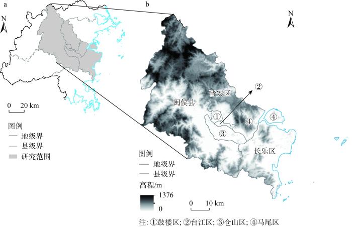
福州市位于福建省东部沿海、闽江下游。近年来,福州市辖区内人地关系日渐紧张。当前,福建省人民政府发布《福州都市圈发展规划》,并大力支持福州市建设强省会城市以及国家中心城市,使得城市土地资源的发展压力进一步加大。因此,针对福州市山多地少、城市用地紧张等一系列问题,本文以福州市七个主要区县(鼓楼区、台江区、仓山区、晋安区、马尾区、长乐区与闽侯县)为研究区(图1),建立融合“功能—结构”双维度的城市建成区土地混合利用研究框架,对促进该地区土地混合利用统筹布局、实现福州市国土空间高效配置,具有一定的实践意义。
图1
本文通过高德API获取到2022年1月福州市七个区县POI数据共260149条,福州市道路数据通过OSM网站(
1.2 研究方法
1.2.1 研究思路
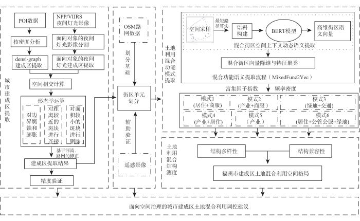
本文的整体研究思路如图2所示,主要分为三部分,第一部分为结合夜间灯光数据与POI数据,提取福州市城市建成区边界,基于提取结果划分建成区内部研究单元(街区);第二部分,结合自然语言处理技术(BERT模型),采用顾及城市混合功能语义的混合模式提取方法(MixedFunc2Vec),对建成区内的街区进行城市混合功能模式提取;第三部分,基于混合功能模式提取结果,融合土地利用结构多样性与兼容性,开展混合功能模式内部的街区测度。最后基于以上研究结果,本文对福州市建成区土地混合利用空间格局进行了综合分析,并提出了针对不同混合功能模式区域的街区尺度空间治理调控建议。
图2
1.2.2 建成区提取与研究单元划分
(1)建成区提取
式中:
式中:定义
将两类数据提取得到的建成区边界进行相交计算,并利用形态学算法对得到的相交结果进行膨胀腐蚀操作,以消除个别细碎区域以及存在的边界不平滑或有尖角的现象,再结合建成区范围内的主要河流分布与路网,对其进行修整,得到最终的提取结果。本文通过目视解译来获取建成区参考边界,与结合夜间灯光数据与POI数据提取得到的建成区边界进行对比,对最终提取结果进行精度评价。
(2)研究单元划分
研究采用OSM道路数据进行单元划分,首先对重复或不完整的道路数据进行删除和补充等预处理工作,并结合福州市高清卫星影像对路网进行进一步修正。考虑到城市中的水系河流对街区划分同样存在一定分割作用,因此为提高研究单元划分的准确性,引入水系河流同时作为分割依据,将处理好的闭合道路生成街区单元,得到最终用于后续研究的街区划分结果。
1.2.3 基于MixedFunc2Vec的土地利用混合功能研究
(1)混合功能语义提取流程
本文基于BERT模型与城市POI数据,研究设计了一种提取混合功能语义的算法(MixedFunc2Vec),以识别城市土地利用混合功能模式。首先,计算每个街区的质心坐标,并以此作为研究范围的采样位置,并使用一种最短路径算法根据点的坐标生成街区语料库,再通过BERT模型训练得到768维高维向量,考虑到BERT获取的语义向量在相似度计算方面效果不佳等问题,本文基于BERT-whitening模型将其降维到256维,利用K-Means算法基于其语义特征,将其进行聚类,得到最终的结果(图3)。
图3
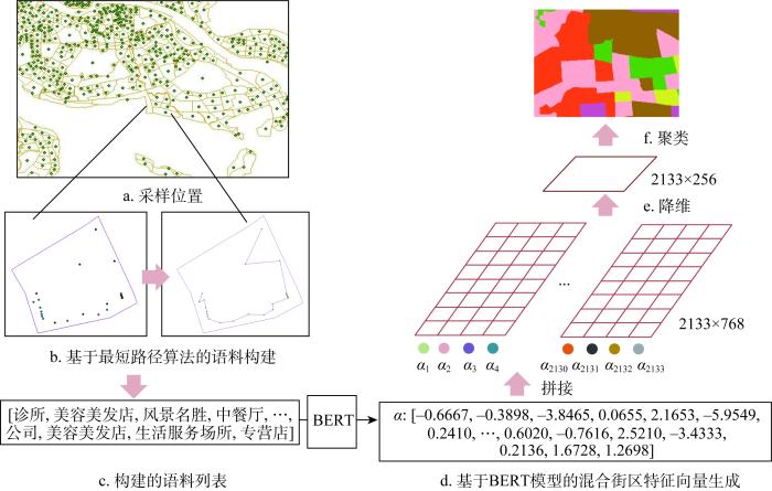
图3
混合功能语义提取流程(MixedFunc2Vec)
Fig. 3
Hybrid functional semantic extraction process
① 语料构建
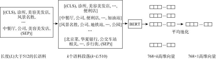
为了增加POI语料的丰富性,本文选择POI数据中的type 3来构建街区语料,为了模仿自然语言中词语的语序,采用Yao等[10]提出的基于贪心思想的最短路径算法,构建街区上下文POI信息。由此,可得到街区的POI列表表示,例如:[(CLS), 诊所, 美容美发店, 风景名胜, 中餐厅, 公司, 美容美发店, (SEP)],用于下一步模型的训练。另外,由于本文采用BERT模型开展POI语义嵌入,而BERT模型存在无法处理过长句子的缺陷,因此采用POI语料分段的处理策略,将输入语料(长度为L)分成k=L/510个小段落,将它们依次输入BERT,得到k个语料段落的表示,使用平均池化来合并所有段落的语义嵌入,从而得到该长语料街区的语义向量表示(图4)。
图4
② 基于BERT模型的混合街区特征向量生成
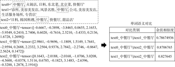
BERT是一种基于transformer架构的语言模型,主要分为预训练和微调两个步骤[25]。与传统的神经网络新语言模型相比,BERT在文本分类、文本相似度、智能问答、文本标记和命名实体识别等多个自然语言处理任务中取得了最好的效果。研究通过将上文构建的POI语料输入BERT模型,以实现对街区混合功能语义的向量化表达(图5)。传统语言模型Word2vec本质上是静态词嵌入,训练结束后,每个单词具有固定唯一的语义信息,无法随上下文内容的变化而作动态调整。而在现实中,不同土地混合利用区域内,同种POI承载的功能语义是不同的,在以风景名胜为主的混合区域中,餐饮POI作为一种辅助功能存在该区域,而在以商业娱乐为主的混合区域中,餐饮POI则是作为一个主要功能存在。因此本文选用能够根据上下文动态调整单词语义的BERT模型开展研究,以解决POI词嵌入的“一词多义”问题,即使对于同类型的POI,如果具有不同的空间上下文关系,其嵌入也会生成不同的向量(图6)。由于BERT训练成本较高,采用谷歌发布的基于中文维基预训练的BERT模型(隐藏层数=12,隐藏单元数量=768,注意力层数=12,总参数=110M,包括7322个预训练汉字字典),以生成符合混合街区特征的768维动态句向量。
图5
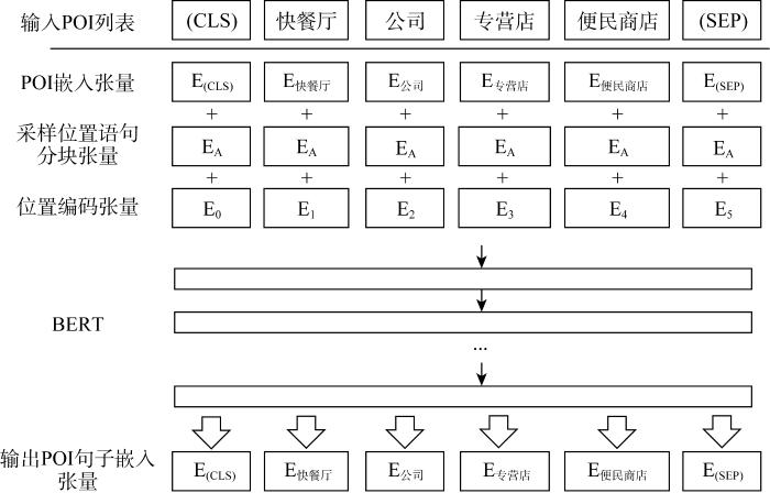
图6
③ 基于BERT-whitening的高维向量降维
得到每个街区的向量表达后,将每个向量进行拼接,得到采样位置数量×向量维数大小的向量矩阵(2133×768),但由于直接使用BERT获取的语义向量在相似度计算方面效果不佳,且生成向量维数过高可能将出现“维数灾难”。因此,为避免其对模式提取结果的影响,本文采用一种简单有效的BERT-whitening方法[26]对其进行降维处理,以提高基于语义信息的模式提取结果准确性,也使其更符合现实世界中的POI单词数目。
④ 基于语义特征的街区向量聚类
参考已有研究[10],本文采用聚类工作中常用的K-means算法将街区句向量进行聚类,使得具有相似混合特征的混合街区集聚,从而提取不同的土地混合模式。
(2)土地利用混合功能模式识别
得到区域聚类后,本文参考自然语言处理中的TF-IDF算法,使用POI频数密度(FD)和富集因子指数(EF)两个指标来计算不同的城市区域中POI的分布情况[27]。
① 频数密度
计算每类POI在每个聚类的频数密度FD,得到每种POI类型在不同聚类中的分布情况。公式如下:
式中:
② 富集因子
本文引入富集因子指数来避免在城市空间中,某些类型POI可能会频繁出现导致对街区功能产生误判的问题,如下所示:
式中:
1.2.4 基于多样性与兼容性的土地利用混合结构研究
表1 POI数据与用地类型对照表
Table 1
| POI大类 | 用地类型 | 影响度(面积) | |
|---|---|---|---|
| 商服用地 | 餐饮服务 | 餐饮用地 | 10 |
| 购物服务 | 零售商业用地 | 15 | |
| 金融保险服务 | 商务金融用地 | 30 | |
| 生活服务 | 其他商服用地 | 10 | |
| 体育休闲服务 | 娱乐康体用地 | 10 | |
| 住宿服务 | 旅馆用地 | 10 | |
| 公共管理与公共服务用地 | 政府机构及社会团体 | 机关团体用地 | 30 |
| 科教文化服务 | 科教文化用地 | 30 | |
| 医疗保健服务 | 医疗卫生用地 | 20 | |
| 一类工业用地 | 公司企业 | 一类工业用地用地 | 30 |
| 二三类工业用地 | 工厂及产业园 | 二三类工业用地 | 70 |
| 物流仓储用地 | 物流仓储场地 | 物流仓储用地 | 30 |
| 农林牧渔用地 | 农林牧渔基地 | 农林牧渔用地 | 60 |
| 交通运输用地 | 交通设施服务 | 交通设施用地 | 15 |
| 居住用地 | 商务住宅 | 居住用地 | 50 |
| 绿地 | 公园绿地 | 公园与绿地 | 95 |
| 风景名胜 | 风景名胜设施用地 | 95 |
(1)结构多样性测度
本文使用生物多样性指数——Hill number来对土地利用混合度进行衡量[29]。
式中:
(2)结构兼容性测度
当前大多数土地混合利用研究仍然缺少对兼容性的测度,而土地混合利用的兼容性更加侧重于用地类型之间的互相协调,为了能够更加充分地展现福州市土地混合利用整体格局,本文基于表1当中各类POI对应的影响度(面积),进而得到各用地类型的面积加权结果,采用Zhuo等[30]提出的基于面积加权向量的混合度指数(Area-Weighted Vector-based Mix Degree Index,WVMDI),以衡量街区间的土地混合利用兼容性,其值越大,表明用地类型兼容性越高,即混合程度越高。该指数充分考虑了用地类型之间的相容性关系以及邻域地块面积的影响,将相邻地块的面积考虑为权重,潜在地反映了土地利用类型之间的外部性效应,是城市土地混合利用兼容性测度的有效衡量指标。
式中:
表2 各用地兼容性一览表[14]
Table 2
| 商服用地 | 公共管理与公共服务用地 | 居住用地 | 一类工业用地 | 二三类工业用地 | 物流仓储用地 | 绿地 | 交通运输用地 | 农林牧渔用地 | |
|---|---|---|---|---|---|---|---|---|---|
| 商服用地 | 0 | 0.03 | 0 | 0.19 | 0.95 | 0.08 | 0 | 0 | 0.05 |
| 公共管理与公共服务用地 | 0.03 | 0 | 0 | 0.55 | 0.98 | 0.53 | 0 | 0 | 0 |
| 居住用地 | 0 | 0 | 0 | 0.45 | 0.99 | 0.45 | 0 | 0 | 0 |
| 一类工业用地 | 0.19 | 0.55 | 0.45 | 0 | 0.06 | 0.01 | 0.45 | 0 | 0.08 |
| 二三类工业用地 | 0.95 | 0.98 | 0.99 | 0.06 | 0 | 0.06 | 0.75 | 0 | 0.64 |
| 物流仓储用地 | 0.08 | 0.53 | 0.45 | 0.01 | 0.06 | 0 | 0.45 | 0 | 0.1 |
| 绿地 | 0 | 0 | 0 | 0.45 | 0.75 | 0.45 | 0 | 0 | 0.03 |
| 交通运输用地 | 0 | 0 | 0 | 0 | 0 | 0 | 0 | 0 | 0 |
| 农林牧渔用地 | 0.05 | 0 | 0 | 0.08 | 0.64 | 0.1 | 0.03 | 0 | 0 |
2 结果分析
2.1 福州市建成区提取与单元划分结果
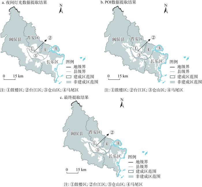
利用夜间灯光数据与POI数据提取得到建成区结果如图7所示,根据福州市相关规划确定的发展战略、方向及空间结构,其结果符合福州市“一轴、两城、六组团”滨江滨海空间发展格局的规划预期,主城区地块完整,靠近长乐滨海新城方向,地块则趋于破碎化。本文将人工目视解译结果作为建成区边界参考,得到精度评价结果:OA=85.63%,取得良好的提取效果。基于提取得到的建成区范围,划分得到2214个街区单元,后续研究将在此提取结果的基础上开展。
图7
2.2 福州市土地利用混合功能模式提取结果
利用本文构建的MixedFunc2Vec方法,得到福州市建成区土地混合功能模式提取结果。根据POI数据与用地类型对照表,以及富集因子与频数密度的计算结果,将福州市建成区内各个街区划分为六个集群区域,即为六类混合模式,每个集群区域均包含多种城市功能类型,与现实世界中城市建成区内的土地利用高度异质化和混合化特点是相一致的。
2.2.1 城市土地混合功能模式提取和分类结果
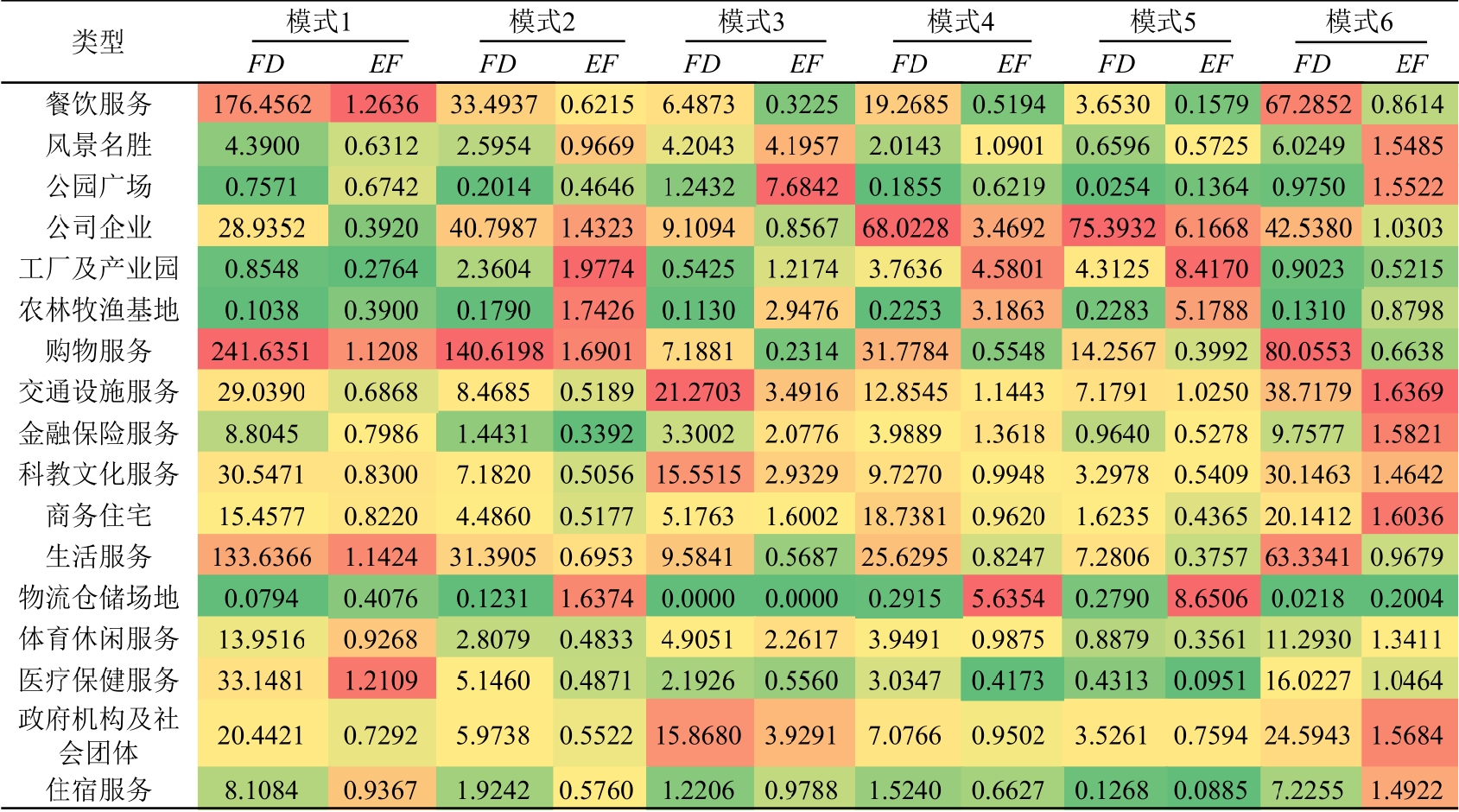
图8
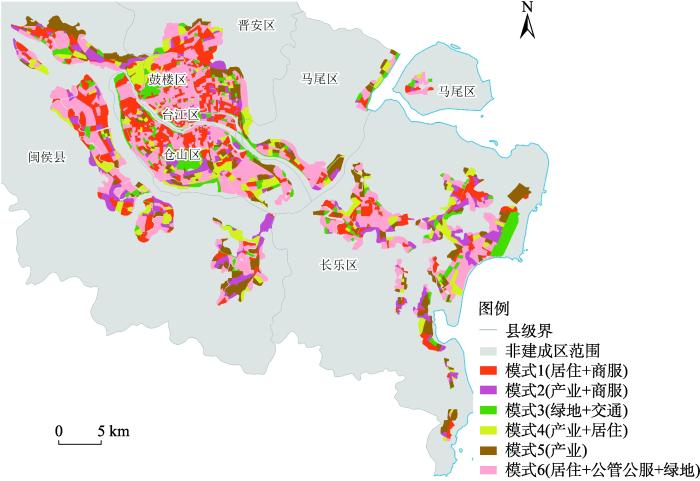
图8
福州市建成区土地利用混合功能模式
Fig. 8
Mixed mode of land use function of built-up areas in Fuzhou
(1)模式1:居住+商服
该混合区域与其他混合区域相比,POI体量较大,且分布有大量商服类POI,区域内EF值与FD较高的均为生活服务(EF=1.14、FD=133.64)、餐饮服务(EF=1.26、FD=176.46)与购物服务(EF=1.12、FD=241.64)类POI,同时也分布着大量金融保险服务、医疗保健服务等服务场所。该区域内分布着东街口商圈、泰禾广场商圈、宝龙广场商圈、上下杭文化街区等福州市最著名的商业街区,同时,通过将模式1区域与其他模式区域进行横向对比可知,模式1区域内分布着较多的商业住宅POI(FD=15.46),因此判断该区域的混合模式为以商服与居住功能主导的混合街区。
(2)模式2:产业+商服
该混合区域EF值最高的分别为工厂及产业园(EF=1.98)、农林牧渔基地(EF=1.74)、购物服务(EF=1.69)、物流仓储场地(EF=1.64)与公司企业(EF=1.43)类POI。同时FD值最高的为购物服务类POI(FD=140.62),远远高于区域内其他类型POI,且此类区域靠近产业主导模式区域,可推断其属于产业功能区域与其他功能区域的过渡性区域。因此,将该区域判断为属于以产业与商服为主导的区域混合模式。
(3)模式3:绿地+交通
该混合区域内公园与风景名胜类POI的EF值最高(EF=7.68、4.20),FD值最高的为交通设施服务类POI(FD=21.27),同时也分布着科教文化服务与政府机构及社会团体类POI,作为辅助功能出现在该区域,该区域覆盖了诸多福州市绿地设施,如西湖公园、牛岗山公园、高盖山公园等,与指标计算结果显示一致,同时也涵盖了高速路口、收费站等与交通相关的POI,以及一些重要交通枢纽如福州站、福州南站等。因此,认为该类区域属于以绿地与交通运输功能为主导的区域混合模式,同时也可体现出福州市绿地设施的交通可达性良好。
(4)模式4:产业+居住
该区域中EF值最高的POI类别依次为物流仓储用地(EF=5.64)、工厂及产业园(EF=4.58)、公司企业(EF=3.47)与农林牧渔基地(EF=3.19),同时,从FD值角度来看,该区域分布着大量公司企业(FD=68.02),也存在着一定数量的购物服务(FD=31.78)、生活服务类POI(FD=25.63)以及住宅(FD=18.74),但这三类POI的EF值处于较低水平,分别为:0.55、0.82以及0.96,由此可知该区域与集群5的产业主导型相比,虽然同样以产业为主导,但相当一部分主导功能为住宅及其他相关配套设施。对照卫星影像可知,该区域主要为居民社区与公司企业、工厂及产业园交错分布地带。因此,综合判断该区域属于以产业和居住为主导的区域混合模式。
(5)模式5:产业
该区域中物流仓储场地(EF=8.65)、工厂及产业园(EF=8.42)、公司企业(EF=6.17)和农林牧渔基地(EF=5.18)的EF值远高于区域内其他类型POI。此外,公司企业类POI的FD值为75.39,区域内分布着大量公司企业,呈现明显的产业主导型混合模式,该区域分布着福州市多个著名产业集聚混合区:福州市软件园、闽侯县经济技术开发区以及福州市主城区东部的富安物流园、福兴经济开发区、东南公路港钢材物流园等。因此,判断该区域属于以产业为主导的区域混合模式。
(6)模式6:居住+公管公服+绿地
相比其他区域,该混合区域内住宅(EF=1.60)、金融保险(EF=1.58)、政府机构及社会团体(EF=1.57)、公园(EF=1.55)、风景名胜(EF=1.55)等多种功能类型POI的EF值均处于较高水平,承载了行政办公、教育科研、文化活动等公共管理与服务功能,如福州市政府机构、大学城均位于该区域内。餐饮服务、购物服务与生活服务类POI的FD值虽然处于较高水平,然而其EF值均小于1,故不考虑将其认定为主导功能类型,而是将其认定为区域之间常见的辅助功能类型,因此将该区域最终判断为居住+公管公服+绿地主导型的区域混合模式,这也说明了公管公服类设施往往倾向于与居民区混合布局,同时也含有大量作为配套设施的餐饮服务、购物服务和生活服务等商服类POI,表明成熟社区往往拥有良好的商业服务。
2.2.2 不同混合区域语义信息对比
本文以每类混合功能模式区域的街区语义向量均值表示该模式类型,并通过计算不同模式语义向量之间的余弦相似度来比较不同模式之间的语义信息。表4为具体计算结果。
表4 混合功能模式向量相似度对比
Table 4
| 模式1 (居住+商服) | 模式2 (产业+商服) | 模式3 (绿地+交通) | 模式4 (产业+居住) | 模式5 (产业) | 模式6 (居住+公管公服+绿地) | 街区数量/个 | |
|---|---|---|---|---|---|---|---|
| 模式1 (居住+商服) | 1 | 0.9189 | 0.7936 | 0.8484 | 0.6598 | 0.9188 | 799 |
| 模式2 (产业+商服) | 0.9189 | 1 | 0.7962 | 0.9221 | 0.9291 | 0.8051 | 239 |
| 模式3 (绿地+交通) | 0.7936 | 0.7962 | 1 | 0.8818 | 0.7601 | 0.7961 | 203 |
| 模式4 (产业+居住) | 0.8484 | 0.9221 | 0.8818 | 1 | 0.9492 | 0.9218 | 182 |
| 模式5 (产业) | 0.6598 | 0.9291 | 0.7601 | 0.9492 | 1 | 0.8047 | 235 |
| 模式6 (居住+公管公服+绿地) | 0.9188 | 0.8051 | 0.7961 | 0.9218 | 0.8047 | 1 | 475 |
由区域语义相似度计算结果可知,针对以产业为主导的混合模式5,模式1(0.6598)、模式3(0.7601)、模式6(0.8047)与之相比,区域语义信息差异较大,说明产业集聚区域和其他几类混合区域在承载功能上存在较明显的空间异质性,但与模式4(0.9492)、模式2(0.9291)相比,区域语义信息则更为相似,这是由于在以公司企业、工厂及产业园为主的区域中,商服类、住宅类更多作为一种附属功能与之共存,具有很强的相关性。模式6与模式4的语义相似度较高(0.9218),这可能是由于在中心城区,住宅类街区总是与一些公司企业、公管公服混合布局。模式1与模式2(0.9189)、模式6(0.9188)相比,语义相似度非常接近,且均分布在福州市三环与附近区域,表明商业服务作为一种重要的城市功能成分,以主导功能或辅助功能的形式存在于城市的混合功能布局中。总体而言,城市是一个空间连贯的多功能混合复杂系统,区域之间既存在空间异质性,也存在相似性。
2.3 福州市土地利用混合结构性测度结果
2.3.1 结构多样性测度结果
本文分别取0.66与0.33为分界线,将福州市建成区结构多样性测度结果划分为高、中、低三类。从面积分布上看,建成区内各街区结构多样性测度值主要集中在中高值区间,总体呈现较高水平。从空间分布上看(图9),区域内总体呈现若干个分散的聚集区,具体表现为由核心向外围逐渐降低的辐射状分布态势,空间布局不均衡。根据空间自相关分析结果表明,福州市建成区内土地利用结构多样性为显著正自相关,具有空间集聚性特征。
图9
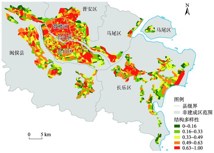
从划分得到的土地利用混合功能模式来看,本文对结构多样性测度结果进行单因素方差分析(ANOVA),可知针对不同土地混合功能模式的区域,其平均结构多样性存在显著差异。模式6(居住+公管公服+绿地)内部土地利用结构多样性最为丰富,高值街区个数有388个,占比超过50%,模式1(居住+商服)次之,模式2、模式3、模式4与模式5则均处于较低的多样性水平,这是由于模式1(居住+商服)与模式6(居住+公管公服+绿地)主要分布在鼓楼区、台江区、闽侯大学城等城市活动丰富复杂的热点地区,区域内功能设施多样,而模式2(产业+商服)、模式3(绿地+交通)、模式4(产业+居住)主要分布在热点地区的周边,以公园绿地、各类产业集聚地与商服、住宅的混合区域为主;以模式5(产业)为主导的区域内则主要为福州市主要的几大产业集中区,以工厂、产业园与公司企业为主,用地结构单一,因此其多样性水平处于最低水平。
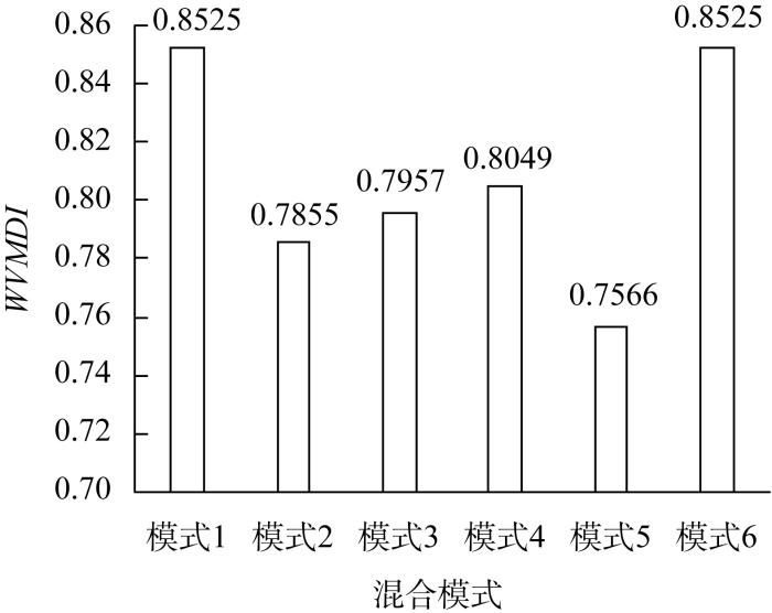
2.3.2 结构兼容性测度结果
福州市建成区结构兼容性测度结果显示,建成区内兼容性水平较高,兼容性归一化指数达到0.7以上的街区约有1803个。从各类土地利用混合功能模式来看(图10),模式1与模式6依然处于较高的兼容性水平,其平均兼容性指数均为0.8525,这是由于这两类模式引导下的街区内部,POI类型丰富齐全,数目众多,且主要为商服、居住、公管公服等对环境无污染或污染性较少的功能类型,其内部产业类型对居住和公共设施等环境基本无干扰和污染,例如电子信息类企业等。因此,以上两类混合模式兼容性程度高;模式4(产业+居住)与模式2(产业+商服)主要为产业、住宅与商服的功能交错区域,由于产业型用地与住宅、商服等用地兼容性较差,因此使得这两种模式的兼容性处于中下水平;而以各类产业为主导的模式5,则处于最低的兼容性水平(0.7566),这是由于其内部公共公服类、绿地类等具有正外部性的POI类型占比较小,且产业类型以化工、机械制造、纺织等为主,对周边环境质量的影响较大,导致土地利用产生的负外部性较强。总体而言,除模式1和模式6之外的区域,即以产业功能为主导的区域及其周边区域,其混合兼容性水平仍有提升空间。
图10
2.4 面向空间治理的福州市建成区土地混合利用格局分析与调控建议
城市土地混合利用在注重结构多样性的同时,也应当注重土地利用类型之间的结构兼容性。因此,本文进一步综合结构多样性与结构兼容性两个街区尺度的土地混合测度指数,通过散点图将计算结果可视化展示,对建成区内的街区进行划分。由于兼容性指数计算结果普遍较高,为实现更准确的划分结果,选择以所有街区的兼容性指数平均值0.8作为分界线;而多样性指数分布更为均匀,则选择以0.5作为分界线,分类结果如图11所示。“高—高”街区,即土地混合利用水平较高,可继续维持现状发展的区域;“高—低”街区、“低—高”街区与“低—低”街区则视为未来仍需进一步提升土地混合利用水平的区域。本文共得到福州市建成区内“高—高”街区651个,“高—低”街区176个,“低—高”街区920个,“低—低”街区386个,由此可知,福州市建成区内除去多样性与兼容性均不足的街区需进行改进之外,还有大量兼容性较高但多样性有待改进的街区。
图11
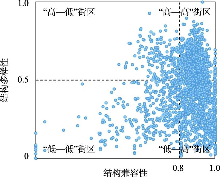
图11
基于“结构多样性—结构兼容性”的街区散点图
Fig. 11
Street scatter map based on "structural diversity-structural compatibility"
图12
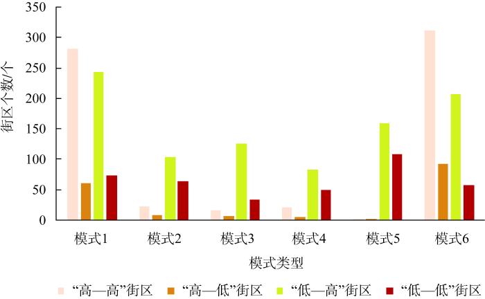
图12
不同混合功能模式下的结构性测度街区个数统计
Fig. 12
Statistics of the number of blocks for structural measurement under different mixed function models
图13
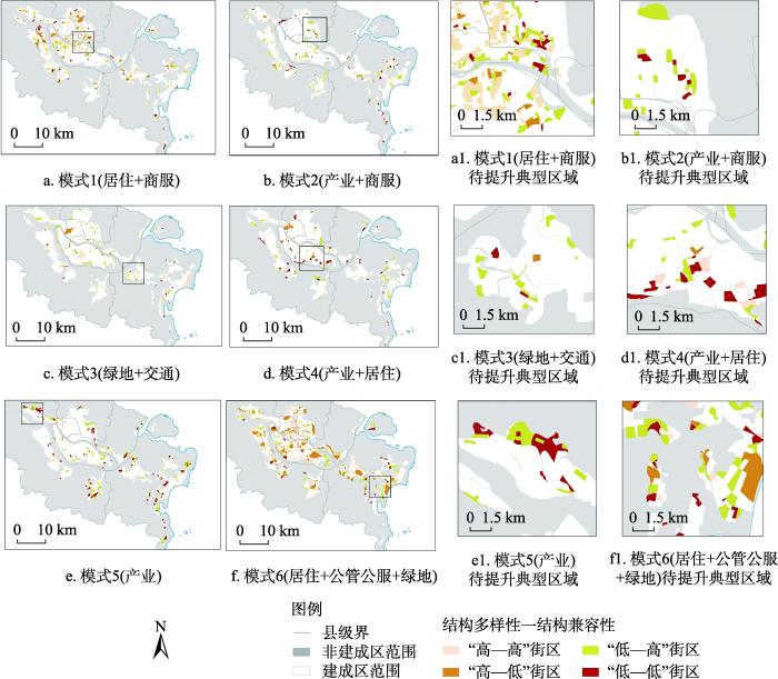
图13
街区尺度下的福州市建成区土地混合利用空间格局
Fig. 13
Spatial pattern of mixed land use in built-up areas of Fuzhou city at the block scale
(1)模式1(居住+商服)
该类模式主导下的街区大致分布于福州市的多个商业中心位置,商住混合特点明显。其“高—高”街区的个数达到建成区内所有“高—高”街区的40%以上,结构兼容性处于区域内的较高水平,相比而言,结构多样性方面则显示不足,“低—高”街区个数有243个,此外,多样性与兼容性均不足的“低—低”街区则有73个,零星分布在建成区各地,因此需主要对以上两类街区进行调整。如图13a1所示的典型区域,其内部分布的主要为以商住功能为主的街区,缺乏其他辅助功能类型,而“低—低”街区则是由于存在公司企业与商住混合而导致的兼容性下降,可后续增加其他对环境影响较小的功能布局,并调整工厂企业布局,以缓解用地冲突与增加街区活力。
(2)模式2(产业+商服)与模式4(产业+居住)
(3)模式3(绿地+交通)
该类模式下各个街区的土地混合利用水平与模式2、模式4相似,具有较多的多样性不足的街区,这是由于该类模式大多数街区地块为公园绿地与城市滨水休闲带,功能较为单一,因此其结构兼容性较高,而多样性较低。该类街区可继续维持以绿地功能为核心,作为城市必不可少的生态空间,发挥其生态游憩休闲价值。而对于图13c1中的街区,位于长乐区吴航组团外围,靠近交通设施的滨水街区,未来可结合上位规划要求,可适当引导其向以公共交通为主导(TOD)或滨水绿地为主题的街区发展。
(4)模式5(产业)
该区域内结构多样性与兼容性均为各类混合功能模式中的最低水平,主要为“低—高”街区与“低—低”街区两类,大部分街区功能结构较为单一,存在多样性不足、兼容性冲突等问题。以包括图13e1中的街区在内的福州市东中西三大工业集中区,闽侯县经济开发区、福兴经济开发区、长乐经济开发区为例,该部分区域内,分布着大量制造业企业、工业园等,包括纺织、冶金、建材等产业,对周边环境质量的影响较大,各地类相互作用引发了环境污染等一系列负外部效应。因此,需进一步盘活区域各功能要素重新流动配置,围绕以产业功能为核心,对其他次要功能进行一定取舍,迁出与产业功能冲突较大的功能布局。
(5)模式6(居住+公管公服+绿地)
该模式的结构多样性和兼容性均处于较高水平,大量分布于中心城区,属于福州市设施齐全且功能协调的成熟街区,分布着福州市主要政府机构、教育科研用地、居住用地以及绿地等。但在长乐滨海新城地区(图13f1)存在个别街区结构多样性处于较低水平,主要为单一商服或居住功能区域,也有大片多样性较高而兼容性较低的街区,这是由于该街区内分布着对兼容性影响较大的工厂企业,并与该街区内的住宅区产生了兼容性冲突,因此可对其进行用地类型的调整,当前长乐区发展正在新兴崛起阶段,未来可继续引入办公、生态绿化、交通站点等空间布局,推动各类功能空间融合及综合开发利用,保证结构多样性与兼容协同提升。
总体而言,针对当前福州市社会经济高速增长、城市土地利用亟需增量提质的发展背景,对不同混合功能模式区域实施针对性的混合利用提升措施是具有一定必要性的。基于不同混合功能模式土地利用特点,迁出或者调入必要的区域功能,协调区域内部各地类相互作用引发的污染等负外部效应,推行环境友好型的用地“增量”开发,避免因兼容性差从而降低人居环境质量等问题,以更好地提升城市土地混合利用质量水平,从而为建立符合不同区域需求的土地混合利用空间差异化治理机制提供支撑。
3 结论与讨论
3.1 结论
本文以福州市建成区内融合“功能—结构”双维度的土地混合利用研究为主要内容,结合自然语言处理技术(BERT模型),构建一种顾及城市混合功能语义的混合模式提取方法(MixedFunc2Vec),提取宏观尺度的城市土地混合功能模式,度量微观尺度街区土地利用结构多样性与结构兼容性,揭示了福州市建成区内土地混合利用空间分布特征,实现城市建成区双维度土地混合利用信息挖掘,并基于以上结果,对福州市建成区各类混合功能模式区域提出了相应的调整建议。具体研究结论如下:
(1)基于BERT模型的语义信息挖掘与动态变化优势,本文构建的MixedFunc2Vec方法解决了传统城市功能语义提取中存在的“一词多义”问题,能够捕捉城市混合功能环境中更加丰富的量化信息。依据POI高维混合功能语义信息,福州市建成区各街区的混合功能模式可划分为六大类:模式1(居住+商服)、模式2(产业+商服)、模式3(绿地+交通)、模式4(产业+居住)、模式5(产业)与模式6(居住+公管公服+绿地)。通过不同混合区域之间的语义信息对比,可知不同混合功能模式的语义空间异质性明显,住宅类街区倾向于与公司企业、公管公服混合布局,而商服则以主导或辅助功能的形式存在于城市的大部分混合功能布局中。
(2)福州市建成区内土地混合利用结构多样性总体呈现较高水平。从空间分布上看,区域内呈现显著的空间正自相关性,呈现多地多中心集聚式发展态势。不同土地混合功能模式的区域,其平均结构多样性存在显著差异,模式6(居住+公管公服+绿地)内部土地利用结构多样性最为丰富,而以各类产业为主导的模式5,其区域内分布有大量产业园区,园区内功能单一,处于最低的多样性水平。
(3)在结构兼容性方面,建成区内兼容性指数达到0.7以上的街区约有1803个。模式1(居住+商服)与模式6(居住+公管公服+绿地)处于较高的兼容性水平,其平均兼容性指数均为0.8525,其余混合功能模式的平均兼容性水平则均处于0.7~0.8之间,模式5(产业)的兼容性水平最低,为0.7566。综合各类模式的土地利用兼容性测度结果来看,以产业功能为主导的区域及其周边区域,其混合兼容性水平仍有提升空间。
(4)综合结构多样性与兼容性的测度结果,将福州市建成区内各街区土地混合利用水平进行定量划分,得到“高—高”街区651个,“高—低”街区176个,“低—高”街区920个,“低—低”街区386个,并进一步结合提取得到的各类混合功能模式,得到每类模式街区尺度下的土地混合利用空间格局。最后,联系福州实际,分析每类模式不同的土地混合利用空间布局情况,并提出面向空间治理的区域功能调整建议,以期能够为建立符合不同区域需求的城市土地混合利用空间差异化治理机制提供支撑。
3.2 讨论
本文的MixedFunc2Vec方法通过采用POI这类实时更新的地理空间大数据,将POI数据映射到高维向量空间,从向量视角解读城市混合区域的功能语义,使得同一种功能类型在不同的城市混合功能环境中可代表不同的内涵,实现功能语义动态变化,为城市土地混合功能模式挖掘提供了新方法。同时,本文除了考虑传统的结构多样性测度之外,增加了对城市用地关系维度的考量,即对结构兼容性的测度,实现了更加全面的城市土地混合利用空间测度,是对现有土地混合利用理论与方法体系的进一步丰富和完善。在对城市进行空间监测与空间治理方面,与传统土地混合利用研究方法相比,本文方法数据获取便捷,时效性强,且成本费用低,能够高效理解城市的复杂功能配置与空间结构,可助力城市规划者实现城市土地混合利用变化趋势的动态监测,及时评估区域在规划、建设后的区域混合功能与结构性变化,从街区尺度辅助实现更具有空间指向性的土地混合利用区域调整策略,可为推进城市国土空间合理布局与区域协调发展提供参考,辅助空间治理决策。
本文构建的融合“功能—结构”双维度的土地混合利用研究框架,是基于POI类型与土地利用类型的对应关系,并考虑POI的占地面积进行的一次研究探索,但本文仅将POI一级类与占地面积进行对应,在进行混合测度时,各个地类的占比可能存在一定误差,且得到的研究结果主要是针对空间水平方向,而对空间垂直方向上的土地混合利用分布仍旧缺乏探讨。此外,在国土空间治理中推行土地混合利用理念,但土地混合利用的上限仍需一定的量化指标。因此,本文后续仍可向以下几个方向进行改进:(1)可结合城市建筑矢量数据及其他多源地理数据,进一步考量城市中土地混合利用的垂直分布;(2)可进一步细化POI二级类、三级类与占地面积之间的对应关系,以减少利用POI数据计算土地利用混合度时的误差;(3)还可对土地混合利用多样性和兼容性的合理取值区间进行探讨,从而为继续完善城市土地混合利用研究、推进国土空间治理与优化提供理论依据和科学支撑。
参考文献
Examining the density and diversity of human activity in the built environment: The case of the Pearl River Delta, China
Rapid urbanization in China has been accompanied by spatial inefficiency in patterns of human activity, of which ‘ghost towns’ are the most visible result. In this study, we measure the density and diversity of human activity in the built environment and relate this to various explanatory factors. Using the Pearl River Delta (PRD) as an empirical case, our research demonstrates the distribution of human activity by multi-source data and then explores its dynamics within these areas. This empirical study is comprised of two parts. The first part explores location information regarding human activity in urbanized areas and shows density and diversity. Regression models are applied to explore how density and diversity are affected by urban scale, morphology and by a city’s administrative level. Results indicate that: 1) cities with smaller populations are more likely to be faced with lower density and diversity, but they derive greater marginal benefits from improving land use efficiency; 2) the compactness of the layout of urban land, an index reflecting the plane shapes of the built environment, is highly correlated with density and diversity in built-up areas; and 3) the administrative importance of a city has a significant and positive impact on the density of human activity, but no obvious influence on its diversity.
基于要素流动的城镇建设用地配置方法框架探讨
DOI:10.31497/zrzyxb.20221102
[本文引用: 1]

现有城镇建设用地配置主要遵循空间开发导向,利用静态数据和用地分配标准、评估及预测模型开展,存在一定的“区域偏好”和“规模求大”现象。在强调生态文明建设和高质量发展的新时期,国土空间规划战略实施要求城镇建设用地配置方法需要及时革新。关注到信息或智能技术深度影响下未来城镇场所空间将转变为流动空间这一必然趋势,不同尺度生产、生活及生态要素时空流动与分配将是城镇建设用地科学配置的关键。因此,利用多源要素流大数据和多学科分析方法,试图从城镇空间发展水平评价、城镇要素流动网络时空模拟与用地分配、城镇要素功能区识别与开发边界划定、城镇建设用地配置效果动态评估4个方面,建立基于要素流动的城镇建设用地配置方法框架。结果表明:(1)城镇空间发展水平评价需要综合考虑城镇对区域现状要素控制、吸引及溢出的能力,并从空间发展规模、活力及品质三个层面构建评价指标体系;(2)在城镇建设用地指标区域分配过程中注重利用网络优化模型和社会网络分析方法刻画区域要素流动规律,并通过时空耦合模型找出不同等级和类型“空间发展水平—要素控制力”组合的城镇;(3)城镇未来扩展方向和边界形态是由内部各类要素流动变化与功能空间布局的供需时空匹配情况决定的,需要利用时空耦合、引力、CA及多智能体等模型识别要素功能影响区和流动偏好;(4)城镇建设用地配置效果评估指标需要体现生态文明、高质量、智慧治理及一体化等未来城镇发展要求和趋势。这些研究结果可以为国土空间规划城镇开发边界划定和实施提供参考。
Discussion on urban construction land allocation based on element flow
DOI:10.31497/zrzyxb.20221102
[本文引用: 1]
The existing urban construction land allocation mainly follows the guidance of spatial development, which is carried out by using static data and land allocation standards, evaluation and prediction models. There are some phenomena of "regional preference" and "seeking large scale". In the new era of emphasizing the construction of ecological civilization and high-quality development, the implementation of territory spatial planning strategy requires that the allocation method of urban construction land needs to be innovated in time. This project focuses on the inevitable trend that the urban place space will be transformed into the urban flow space under the deep influence of information or intelligent technology in the future, and considers that the spatiotemporal flow and distribution of production, life and ecological elements of different scales will be the key to the scientific allocation of urban construction land. Therefore, the project uses multi-source big data of element flow and multi-disciplinary analysis methods, trying to establish a new method framework from four aspects: evaluation of urban spatial development level, spatio-temporal simulation of urban element flow network and land allocation, identification of urban element functional area and delimitation of development boundary, and dynamic evaluation of urban construction land allocation effect. Firstly, it is found that the evaluation of urban spatial development level needs to comprehensively consider the ability of cities to control, attract and overflow the current regional elements, and construct the evaluation index system from three aspects of spatial development scale, vitality and quality. Secondly, in the process of regional distribution of urban construction land index, we pay attention to using network optimization model and social network analysis method to describe the flow law of regional elements, and find out the cities with different levels and types of combination of "spatial development level and element control" through time-space coupling model. Thirdly, the future expansion direction and boundary shape of cities are determined by the spatiotemporal matching of supply and demand between the flow changes of various internal elements and the functional space layout. It is necessary to identify the functional influence area and flow preference of elements by using models of spatiotemporal coupling, gravity, cellular automata and agent-based system. Finally, the evaluation index of urban construction land allocation effect needs to reflect the requirements and trends of future urban development, such as ecological civilization, high quality, smart governance and integration. These research results can provide reference for the delimitation and implementation of urban development boundary in territory spatial planning.
中国省会城市紧凑度与城镇化水平关系
DOI:10.31497/zrzyxb.20200307
[本文引用: 1]
紧凑型城市建设作为新时期有效避免城市无序蔓延发展、提升城市发展质量和实现土地资源高效利用的新途径,探明城市紧凑度与城镇化的关系对实现城市可持续发展至关重要。基于此,以中国30个省会城市和直辖市为研究对象,综合运用熵值法和容量耦合系数模型测度省会城市紧凑度和城镇化的综合水平,并分析了二者的耦合协调关系。结果发现:(1)2006-2016年间中国省会城市紧凑度东、中、西部地区依次递减,东部省会城市水平最高,整体紧凑度随时间呈增长趋势;(2)高低紧凑度城市逐渐减少,中低紧凑度城市逐渐成为主体;(3)我国大多数省会城市紧凑度与城镇化关系整体以濒临协调为主,总体由失调状态向协调状态演变。
The relationship between urban compactness and urbanization level in capital cities of China
DOI:10.31497/zrzyxb.20200307 URL [本文引用: 1]
土地混合利用测度研究进展
Research progress on the measurement of mixed land use
基于北京公交刷卡数据和兴趣点的功能区识别
Identifying urban functional zones using bus smart card data and points of interest in Beijing
基于潜在语义信息的城市功能区识别: 广州市浮动车GPS时空数据挖掘
DOI:10.11821/dlxb201603010
[本文引用: 1]
随着中国城市化进程的不断推进和深入,城市内部空间结构正发生不断的变化.城市内部形成的不同功能区标识研究,对城市结构理论以及政策制定,资源配置等方面具有非常重要的意义.这些不同的功能区包括住宅区,工业区,教育区以及办公区等.本文以大数据为依托,重点研究城市功能区的特点和分布状态,选取广州市6个区为样本,以最新道路网络为分割依据把研究样本分为439个区域.对历时一周的海量浮动车(GPS)数据以及兴趣点数据采用时空语义挖掘方法,建立潜在的狄利克雷模型(LDA)以及狄利克雷多项式回归模型(DMR);通过OPTICS聚类方法对不同模型的结果进行聚类,进而利用POI类别密度,居民出行特征等方法进行分区结果识别.同时,参考百度地图的地理信息,将研究得到的广州市功能分区结果与广州市城镇用地现状图,居民日常出行特征进行对比验证分析.研究表明,该方法基本能识别出具明显特征的城市功能区,如成熟居住区,科教文化区,商业娱乐区,开发区等.识别出的广州市不同类型的功能区呈现了以居住区和商业区为主导,其他类型功能区围绕其展开的特点.研究证明,利用大规模,高质量的个体时空数据开展人们移动行为和日常活动组织及社会空间的研究,能从一个新的视角揭示城市功能区的形成及其机制.
Discovering urban functional regions using latent semantic information: Spatiotemporal data mining of floating cars GPS data of Guangzhou
DOI:10.11821/dlxb201603010
[本文引用: 1]
China has been experiencing rapid urbanization at an unprecedented rate and as a result, urban internal space structure has evolved significantly. It is of great significance to label different functional regions (DFR) inside a city for urban structure analysis, policy making, and resource allocation. These DFRs include residential district, industrial district, education district, and the administration district. This paper explored the characteristics and distribution of urban functional regions based on big geographic data. With the latest road network data, the study area (i.e., 6 districts of Guangzhou city in Guangdong Province, China) was partitioned into 439 segments. By applying the employment of spatial and temporal semantic mining method to the one-week massive floating cars GPS data and the point of interest data, we developed a Latent Dirichlet Allocation (LDA) and Dirichlet Multinomial Regression (DMR) model. Moreover, OPTICS clustering method was employed to process the results of LDA and DMR to identify different functional zones. Meanwhile, status map of Guangzhou urban planning, and resident travel characteristics were used to verify the verification of mentioned results. The results show that this method can identify the obvious characteristics of urban functional areas, such as mature residential area, science and education culture area, commercial area, and development zone. The results also show that residential and commercial areas are dominant DFRs in Guangzhou city, which are surrounded by other types of functional regions. This paper brings a new perspective on using large-scale and high quality individual space-time data to study human migration and daily activities, as well as to explore social space to unveil the formation and mechanism of urban functional zones.
The Traj2Vec model to quantify residents' spatial trajectories and estimate the proportions of urban land-use types
DOI:10.1080/13658816.2020.1726923 URL [本文引用: 1]
北京市四环内街区尺度下的主题混合模式挖掘
DOI:10.12082/dqxxkx.2020.190594
[本文引用: 1]
城市是多样性聚集的场所,且多元化和差异性日益增强,故探究土地混合利用具有一定的现实意义。现有的土地混合研究大多以POI(Point of Interest)为研究基础,着眼于城市主题的研究较少。本文采用百度POI数据,在街区尺度下考虑POI共现以提取主题,并挖掘北京市四环内的主题混合模式,其结果可以为城市规划及其建设提供参考。首先,采用LDA(Latent Dirichlet Allocation)主题模型得出街区的主题向量以及主题的POI共现模式;其次,引入多样性指数对街区的混合度进行度量,并依据自然断裂法将街区分为高混合街区、中等混合街区、低混合街区3类;最后,为了探究3类街区中的主题混合模式,先采用多元线性回归找出不同类街区中对混合度影响显著的主题,在此基础上对街区中的混合模式进行提取。结果表明:高混合街区的主题混合模式都是茶座餐厅主题与其他主题的混合;中等混合街区中的混合模式大多是以公司企业主题与住宅(商铺)主题再结合其他主题的混合;低混合街区中最典型的2种模式是茶座餐厅主题主导与风景名胜主题主导的接近单一的模式。不同的模式也体现了不同混合区的特征及其之间的差异,有助于对城市深度理解,从而为混合城市的建设提供参考。
Extracting mixed topic patterns within downtown Beijing at the block level
Sensing spatial distribution of urban land use by integrating points-of-interest and Google Word2Vec model
DOI:10.1080/13658816.2016.1244608 URL [本文引用: 3]
Determinants of distance traveled with a focus on the elderly: A multilevel analysis in the Hamilton CMA, Canada
DOI:10.1016/j.jtrangeo.2008.04.012 URL [本文引用: 1]
The development and application of a land use diversity index for Oklahoma city, OK
DOI:10.1016/j.apgeog.2015.02.015 URL [本文引用: 1]
论农村居民点用地混合利用的研究框架
Discussion on mixed use of rural residential land research framework
DOI:10.31497/zrzyxb.20201209
[本文引用: 1]
Mixed land use advocates that the land has multiple uses and functions, which is an important way to improve the vitality of economic development and the intensive use of land. At present, mixed land use is mainly applied in urban land use evolution and planning practice. With the intensification of urban-rural interaction, the urban-rural boundary tends to be blurred, and the internal structure and function of rural residential land in urban suburbs are gradually diversified, showing significant mixed utilization characteristics. Based on this, this paper attempts to apply mixed land use to the evolution and planning of rural residential land use. On the basis of reviewing the theory of mixed land use and its application, according to the logic of "connotation characteristics-quantitative evaluation-driving mechanism-practice approach", the systematic analysis of the mixed use of rural residential land in urban suburbs was carried out, and the optimization of rural residential areas was proposed. Finally, we take Yaocun village, which is located in the suburbs of Tianjin, as an example to demonstrate the research framework proposed in this paper. The ideas and plans for the mixed land use theoretically enrich the methods and framework for the transformation of rural residential land use, and provide scientific support for the preparation of village planning and the implementation of the strategy for rural revitalization in practice.
土地混合使用视角下的地块间兼容度测度: 以湖南省湘潭市市辖区为例
DOI:10.13284/j.cnki.rddl.003361
[本文引用: 2]
在梳理已有土地兼容度的测度思路后,基于社会分隔的空间测度算法提出了一种从地块和街区双尺度测度地块间兼容度的新方法。与既有方法相比,新算法一方面将所有建设与非建设用地均纳入计算,力求更好地体现用地兼容度格局;另一方面也充分考虑了诸如相邻边长,领域面积等土地利用格局的重要空间几何特征,避免了传统算法无法量化距离衰减的缺陷,从而更加科学地描绘土地利用兼容度的分布特征。以湖南省湘潭市市辖区作为案例,在地块和街区2种尺度上进行实证研究。结果发现,湘潭市土地利用现状整体较为兼容,但仍然存在部分兼容度较低的聚集区域。这类区域基本位于城市郊区的工业园区和村集体用地上。其主要原因有二:其一,在工业园区中,过分重视工业企业的招商引资而忽视了规划管理,导致土地的真实利用情况与既有规划不符,一定程度上造成用地的不兼容现象;其二,在城边村的集体用地上,部分村级工业地块的无序扩张加剧了与宅基地、耕地等环境敏感用地的交织,继而形成不兼容的用地景象。最后,基于测度结果,从街区尺度上对湘潭市不兼容区域提出了对应的完善策略,以求在后续空间规划中提升湘潭市土地的混合利用程度。
Measuring the functional compatibility of land from the perspective of land-use mix: A case study of Xiangtan
DOI:10.13284/j.cnki.rddl.003361
[本文引用: 2]
Land-use mix is regarded as an effective method to improve urban quality and optimize built-up areas. In urban studies, this theory is usually defined in terms of diversity. Methodological approaches rely heavily on diversity in land use, but they often fail to consider functional compatibility as another critical characteristic, thus providing only a partial picture of land-use patterns. Although quantitative frameworks of land-use mix are mature and comprehensive, methods to measure functional compatibility are seldom discussed. Thus, by reviewing the literature on functional compatibility measurements, this paper proposes three new indices to gauge the degree of compatibility between land uses based on the quantitative approaches of social segregation. After considering existing methodologies, the paper first focuses on all land-use types, including undeveloped land, in order to capture hidden incompatibility; second, it considers all possible geo-features and includes them in the measurement process; and third, it attempts to interpret the functional compatibility of blocks and parcels of land to provide a basis for the district-level planning at scale of a block of land. To provide empirical evidence, this paper uses Xiangtan city as a case study—a typical medium-sized city in China, and representative of other third-tier cities—to evaluate the proposed indices. The general findings suggest that, overall, current land-use compatibility in Xiangtan is relatively good, but there are still some incompatibilities between neighboring lands. Most of the land has been developed for industrial purposes in a suburban industrial park. Industries, especially Class II industries, often generate pollutants such as noise, wastewater, and air pollution that have a huge negative environmental impact on the surrounding areas. These impacts can be effectively minimized through zoning and planning schemes that restrict industries to allocated areas, such as industrial parks or industrial zones. However, this is not always possible, partly due to the imperfect process of land acquisition that invalidates the intended benefits of planning schemes. Over time, the cumulative effect of these compromised planning schemes is an absence of scientific land-use management and a fragmented, complex, and incompatible pattern in land use. Based on the block-level indices we developed, we created a map of bivariate scatter plots for strategy making to improve the land-use mix in Xiangtan city through spatial planning.
农村居民点用地混合利用特征及驱动力
Characteristics and driving forces of the mixed use of rural settlement land
基于POI数据的城市土地混合利用评价及影响因素分析: 以杭州市主城区为例
Assessment on urban mixed land use and analysis of lts influencing factors based on pol data: A case of the main districts of Hangzhou city
基于POI数据的建设用地多功能混合利用空间分异研究
DOI:10.18306/dlkxjz.2022.02.005
[本文引用: 1]
建设用地多功能混合利用对提升区域用地效率、增进国土空间效能具有重要意义。论文构建基于生产—生活—生态空间(即三生空间)的建设用地多功能混合利用分析框架,以济南市为研究区,采用POI数据,利用熵模型、景观格局分析和关联规则挖掘方法,探究土地混合利用的空间分异特征。结果显示,研究区建设用地混合利用以生产空间、生产—生活空间和生活空间为主;核心城区的建设用地混合利用度较高,而生产、生活空间集中连片,生态空间嵌入不足;乡村地区景观的破碎化特征明显,以生产—生活空间引领的建设用地混合利用度较低;产业园区的生活—生态空间在网络中处于边缘位置,加强园区内部规划与周边区域形成互补的生活、生态空间,是实现园区土地可持续利用的关键。关联规则的分析结果表明,科学的生产空间规划是优化混合利用的重要抓手,而合理的生态空间布局对带动区域建设用地混合利用起着关键作用。研究基于POI数据,从行为空间互动理论视角探究建设用地多功能混合规律,丰富了现有土地混合利用理论与方法体系,也为土地利用政策制定及城市空间格局优化提供了科学依据。
Spatial differentiation of multi-functional mixed use of construction land based on points of interest
DOI:10.18306/dlkxjz.2022.02.005
[本文引用: 1]
Mixed land use is of great significance for improving the efficiency of use of regional land and territorial space. A framework for analyzing and optimizing multi-functional mixed use of construction land based on production-living-ecological space was developed in this study. Based on the point of interest (POI) data, entropy model, landscape pattern analysis, and association rules mining were applied to explore the spatial differentiation of mixed land use, taking Jinan City as the study area. The results show that the main types of mixed use of construction land in the city are production space, production-living space, and living space. The degree of mixed utilization of the core urban area is high, the production and living spaces are concertrated and connected, however, the ecological space is not embedded enough. The landscape fragmentation in the rural areas is obvious, and the mixed use led by production and living space is weak. The living-ecological space in the industrial parks is in a very marginal position in the network. Strengthening the internal planning of the parks or forming a complementary living and ecological space with the surrounding areas is the key to realize the sustainable development of the parks. The research of association rules shows that reasonable production space planning is an important way to guide and optimize the mixed land use. At the same time, strengthening the rational use of ecological space plays an important role in promoting mixed land use. Based on the POI data, this study explored the patterns of multi-functional combination of construction land from the perspective of behavioral spatial interaction theory, which enriches the existing land mixed use theory and methods and provides a theoretical basis for land use policy making and spatial pattern optimization.
基于POI与不透水表面指数的城市建成区提取
DOI:10.13249/j.cnki.sgs.2022.03.015
[本文引用: 1]
准确识别城市建成区边界,对科学实施城市规划和建设、促进城乡可持续发展具有重要意义。从城市建成区概念出发,综合考虑建成区连片和公共设施配置,提出一种基于POI核密度与不透水表面指数的建成区边界提取方法。该方法以不透水表面指数和市政公用设施和公共设施POI核密度为主要数据源,通过构建城市建成区综合指数(POI&ISA指数)和最佳阈值选取等步骤可实现较为准确的城市建成区提取。以武汉都市发展区为例,将该方法与基于POI方法的建成区提取结果进行对比,结果表明基于POI&ISA指数的方法提取精度较高。该方法可弥补单一POI数据源在城市尺度建成区提取中的不足,且通过对POI数据类型初选和带宽的适当选取提高对公共设施配置的表征能力,在局部地区可获得更好的建成区提取效果。
Extracting urban built-up area based on impervious surface area and POI data
DOI:10.13249/j.cnki.sgs.2022.03.015
[本文引用: 1]
Accurate identification of urban built-up area boundary is of great significance to implement urban planning and construction scientifically and promote sustainable development of urban and rural areas. From the definition, urban built-up area is the surface space with dense construction land and complete municipal public facilities and public facilities. However, existing urban built-up area extraction methods only consider one feature of built-up areas. Based on the concept of urban built-up area, this article takes the contiguity of construction land and the configuration of public service facilities into account, proposing a method of urban built-up area extraction based on POI kernel density and impervious surface area index. In this method, impervious surface area index and POI kernel density of municipal utilities and public facilities are used as main data sources, and urban built-up area can be extracted accurately by constructing POI&ISA index and selecting optimal threshold. Taking Wuhan urban development area as an example, compared with the results of built-up area extraction based on POI method, it is proved that the method based on POI&ISA index has higher extraction accuracy. This method can make up for the deficiency of single POI data source in urban built-up area extraction, improve the representation ability of public facilities through POI data primary selection and appropriate selection of bandwidth, and obtain better extraction effect of urban built-up area in local area. Moreover, the data required by this method has the characteristics of fast updating, which can fully guarantee the timeliness of extraction of built-up areas. In the future, the application and improvement research of POI&ISA index should be further carried out to enrich the theory and method of urban built-up area extraction.
夜间灯光数据和兴趣点数据结合的建成区提取方法
Extraction method of built-up area by combining night light data and interest point data
Using multi-source geospatial big data to identify the structure of polycentric cities
DOI:10.1016/j.rse.2017.06.039 URL [本文引用: 1]
基于H/T断裂法与POI数据的建成区快速提取方法
A fast extraction method of built-up area based on H/T breaks method and POI data
基于兴趣点密度与城市扩张曲线的城市建成区边界识别
Identifying the boundary of urban built-up area based on density of POI and urban expansion curve
利用夜间灯光POI的城市建成区提取精度研究: 以珞珈一号01星和NPP/VIIRS夜间灯光影像为例
Extraction accuracy of urban built-up area based on nighttime light data and POI: A case study of Luojia 1-01 and NPP/VIIRS nighttime light images
基于电子地图兴趣点的城市建成区边界识别方法
DOI:10.11821/dlxb201606003
[本文引用: 2]
城市建成区边界是认识和研究城市的重要基础性信息,也是落实城市功能空间布局、实施界限管控的前提。但是,以往通过夜间灯光的强度、土地覆被或建筑覆盖率等信息获取城市空间范围的方法,由于受到数据精度和尺度限制,对城市社会经济活动的解释性不强,因而存在较大局限性。电子地图兴趣点(POI)作为城市空间分析的基础数据之一,直观且有效地反映了各类城市要素的集聚状况。本文基于POI与城市空间结构和城市要素空间分布的关联性,提出了一种新的通过POI密度分布来判别城市建成区边界的技术方法。为此,开发了Densi-Graph分析方法,用来分析POI密度等值线的变化趋势,在此基础上对城乡过渡地带的阈值识别的方法进行了理论分析,并讨论了单中心圆结构、双中心“鱼眼型”结构、双中心“子母型”结构等各类城市POI密度等值线的生长规律,证明了Densi-Graph分析方法的适用性。较之以往的城市建成区边界识别方法,这种方法的基础数据更加直观可信,分析结果也更加客观。运用这种方法,本文对全国地级以上城市的建成区边界进行了实证分析,探索了城市建成区边界的阈值及其与城市人口规模、城市所在区域之间的关系。
A novel method for identifying the boundary of urban built-up areas with POI data
DOI:10.11821/dlxb201606003
[本文引用: 2]
The boundary of urban built-up areas provides foundational information for urban studies and meets the requirements for urban pattern and urban spatial structure research. However, commonly used methods for identifying the boundary of urban built-up areas such as using remote sensing data of night-light and land use, cadastral data, and building coverage data, are limited in accuracy. To remedy this, this paper proposes to use POI (Point of Interest) data obtained from web maps, assuming that it well reflects the agglomeration of urban activities at higher precision. Based on the underlying connection between POI and the spatial distribution of urban activities, a new method called 'Densi-Graph' is proposed to identify the actual boundary of urban built-up areas with the contour map of the kernel density of POI, where the threshold value for the contour lines to make significant change from densely to loosely placed is picked, giving the boundary of urban and rural areas. Different contour structures for mono-centric, poly-centric and linear cities are discussed, whereby the Densi-Graph method using POI data is validated. The method is also used to study the boundaries of urban built-up areas in China's prefecture level cities. The relationships between the Density-Graph thresholds and the population and location of different cities are discussed. This study advances previous studies in presenting more reliable and objective data on the boundary of urban built-up areas.
Beyond Word2vec: An approach for urban functional region extraction and identification by combining Place2vec and POIs
DOI:10.1016/j.compenvurbsys.2018.11.008 URL [本文引用: 1]
基于POI数据的中心城区“三生空间”识别及格局分析: 以上海市中心城区为例
Recognition of "ecological space, living space, and production space" in the urban central area based on POI data: The case of Shanghai
Diversity and evenness: A unifying notation and its consequences
DOI:10.2307/1934352 URL [本文引用: 1]
Compatibility mix degree index: A novel measure to characterize urban land use mix pattern
DOI:10.1016/j.compenvurbsys.2019.01.005 URL [本文引用: 1]
