

耕地保护是推动农业发展和筑牢粮食安全的基础,是关系到中国和全球经济社会可持续发展的战略性问题[1,2]。2022年中央一号文件明确要求粮食主产区、主销区和产销平衡区都要保护耕地面积和粮食产量。然而耕地具有资源稀缺性和价值外部性,粮食安全、生态保护和经济社会效益无法直接度量,与政绩考核挂钩的经济发展效益驱动建设用地不断扩张,耕地保护面临着优质耕地流失和空间错配的严峻挑战[3⇓-5],因此,中国实施了一系列的耕地保护政策,对耕地实行空间分区管制和指标配额约束的双层管控[6⇓⇓-9]。其中,1986—2000年、1997—2010年和2006—2020年三轮土地利用总体规划中都设置耕地保护指标,通过政府调控对市场机制的引导,优化耕地资源的空间配置并提升利用效率,约束耕地规模底线,是空间分区管制的基础[10,11]。2019年底,中共中央和国务院出台了《关于建立国土空间规划体系并监督实施的若干意见》,将土地利用规划、主体功能区规划和城乡规划等进行“多规合一”,构建“五级三类”统筹综合布局的国土空间规划体系,其继承了以往规划中的指标管控和用途管制方式,并在此基础上构建支撑国土空间规划目标的规划指标体系[12,13]。在此体系中,耕地保护指标仍是明确耕地保护责任和规范建设用地空间开发的基础与关键,对促进土地资源可持续利用和落实国土空间规划具有重要意义[14⇓-16]。
耕地保护指标是空间规划的核心政策工具,在不同层级政府土地利用规划之间“自上而下”分配,对耕地规模底线进行约束性管控[17,18]。目前中国已逐步形成“以土地利用总体规划为约束,以年度土地利用计划、永久基本农田保护为主要内容”的耕地保护指标体系[19],在国土空间规划中也按照其性质划分为约束性、预期性和建议性指标,其中约束性指标贯彻最严格的底线思维。约束性指标中的耕地保有量指在土地利用总体规划中该区域必须保证的耕地总数量的底线规模,《土地管理法》中明确规定其不得低于上一级规划所确定的控制指标[20]。作为18亿亩(1亩≈667 m2)的耕地红线和粮食战略安全的基本保障,耕地保有量是耕地保护指标中最关键的指标[21]。在指标分配过程中,上级政府根据规划分区发展方向和差别化的区域土地利用政策,对经济建设发展和耕地资源保护进行调控,向下级政府分配耕地保护指标,统筹区域空间规划布局[22⇓-24]。因此,如何进行耕地保护指标的有效分配是完善耕地保护政策和推进国土空间规划体系建设的关键问题。
现有针对耕地保护指标分配的研究主要从三个方面展开:耕地保护指标的分解预测方法优化、指标分配结果的绩效评价以及国土空间规划中指标体系的构建探讨。首先,以某个区域为例进行指标分解预测,运用德尔菲方法、熵权系数法和层次分析法等确定分解指标权重和优化分解方法[25⇓⇓-28]。但这些研究多聚焦于某个地理单元内耕地保护指标分配方法的更新和效应评估,缺乏对不同粮食战略分区之间政府决策偏好差异和不确定性的考虑[29,30]。其次,围绕耕地保护指标分配结果对保护耕地和限制城市扩张的绩效进行评估,通过规划指标与实际土地利用变化对比的实现指数和耕地压力指数探究指标分配的合理性[31,32],或将规划指标作为回归模型变量探究其对城市土地利用变化的效用[33],结果表明现有的指标分配结果存在失效现象。指标失效的一个重要原因是中央政府对于耕地保护的需求与地方政府对于经济发展的需求之间存在矛盾,但指标分配研究中较少考虑上下级政府间的目标差异,以及地区间指标空间分配的效率和公平问题[34⇓⇓-37]。最后,在新的国土空间规划背景下探讨规划指标的统筹协同,强调“多规合一”后多目标指标的协同治理,提出构建国土空间规划战略导向的指标体系[38⇓-40]。但此类研究多为定性分析,尚未形成一个定量的指标分配体系。综上所述,现有指标分配研究所得到的结果具有较低的普适性,没有构建起一个在区域空间差异和政府目标差异综合影响下的,面向国土空间规划导向的耕地保护指标分配框架。
针对上述问题,本文以2006—2020年土地利用总体规划中,省级向市级政府分配的耕地保有量指标为例,面向国土空间规划体系构建耕地保护指标分配的分析框架。首先,结合粮食主产区、主销区和产销平衡区省份的战略定位,探讨不同粮食分区指标分配策略的差异性;其次,结合中央政府与地方政府的目标差异,基于多政府层级探究指标分配策略的影响因素,讨论指标分配策略的合理性和指标失效的原因。拟通过耕地保护指标分配的研究,优化耕地保护指标的空间分配格局,保护耕地资源和约束建设用地扩张,提升耕地保护规划政策的应用效果,推动国土空间规划体系建设。
1 研究方法与数据来源
1.1 分析框架
在中国上下级政府规划之间“自上而下”进行耕地保护指标分配的过程中,不同省份指标分配策略的空间布局和偏好因素存在差异。本文将从市级行政单元、省级行政单元和政府交互作用三个维度构建分析框架,探究耕地保护指标分配策略的规律,讨论不同省份指标分配策略的同质性与差异性(图1)。
图1
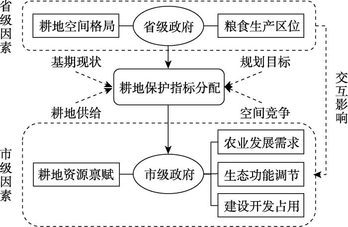
(1)省级政府向市级政府分配指标时,首先需要明确各市级单元耕地资源禀赋供给的基准,在此基础上对农业发展、生态调节和建设开发三部分区域进行空间规划,赋予各市级单元耕地保护的不同责任。在耕地总量动态平衡政策影响下,耕地保有量指标作为约束耕地保护底线的重要政策工具,应当以耕地资源禀赋的供给差异为依据进行分配[41,42]。在此基础上,国土空间规划中划定三区三线,统筹布局农业、生态、城镇等功能空间,划定落实永久基本农田、生态红线和城镇开发边界,因此省级政府必须权衡规划三种空间在不同市级行政单元的土地分配情况。在基期耕地资源规模的基准上,推动农业耕地集约利用能够最大限度提升有限耕地资源的综合效益,实质上会保护性地增加单位耕地的资本投入和劳动投入,因此不同市级行政单元耕地集约利用程度会使得该区域农业发展对耕地的需求存在差异[43,44]。一方面,虽然耕地具有农田生态系统的生态价值,但由于毁林复垦等行为,大量森林和草地被转换为耕地,导致原有的生态环境被破坏,造成水土流失和水资源短缺等问题,因此省级政府应结合当地的生态环境情况进行耕地指标分配[45,46]。另一方面,建设开发占用是区域内耕地流失最主要的形式,随着经济发展和城镇化进程的推进,建设用地不断向外扩张占用耕地[47,48]。因此省级政府需要明确各市级行政单元的城市优先发展权,以留足一定的土地开发空间,并以耕地保有量指标约束区域内建设用地的扩张,提升其集约利用水平[49]。
(2)省级政府不仅考虑市级行政单元的耕地供给与空间竞争,同时考虑省级尺度耕地空间集聚分布格局和粮食生产区位。一方面,省级尺度的耕地空间格局能够反映基期耕地资源分布的集聚程度,不同省份之间存在耕地保护指标分配格局和策略的空间差异,而这种差异同时受地理经济指标和空间指标的影响[50,51]。另一方面,省级尺度的粮食生产功能能够反映其粮食生产的战略定位,从而影响其指标分配的空间策略。依据以往的主体功能区划,在国家和省区尺度上的地域功能区包括城市化、粮食安全、生态安全、文化和自然遗产区域共四大类,在此基础上又划分到县级尺度的四类主体功能区开发类型[52]。从主体功能区规划到国土空间规划保护新格局,耕地保护指标在五级行政区划之间自上而下逐级进行分配,在由省级向市级行政区进行指标分配时,省级尺度的粮食生产功能区划起到至关重要的作用。因此不同粮食生产集中度的省份,其耕地保有量指标的分配策略对经济发展和耕地保护的偏好也会存在差异[53]。
(3)在指标“自上而下”传导过程中,不同省份根据基期现状和规划目标的差异产生对市级行政单元因素偏好的差异,由此产生跨层级的交互影响。由于上下级政府间信息不对称和规划理念的差异,指标分配博弈时下级政府会要求更多扩张性指标如新增建设用地规模等,减少约束性指标如耕地保有量等[54,55]。但这种博弈并不是省级政府与某个市级政府之间一对一的博弈,而是省级政府与各个市级政府的一对多博弈,以及各市级政府之间的综合博弈过程。博弈的最终结果也并不只是依靠地方政府的博弈能力,而是省级政府在各方主体多次博弈过程中,根据基期现状和规划目标寻求理性和均衡的最优解,最终体现在省份指标分配策略的异质性[56]。在不同政府层级的交互作用影响下,不同省份的耕地保有量指标分配策略出现差异,导致指标空间分配格局的异质性。
(4)上述理论分析框架在粮食主产区、粮食主销区和产销平衡区可能会存在不同表现。不同粮食功能产区的粮食生产模式和影响因素都存在差异,在粮食生产空间网络中,粮食主产区占据核心的主导地位,具有粮食生产比较优势,需要不断提高粮食综合生产能力,以保障向其他地区的粮食供给;主销区和产销平衡区位于边缘区位,要稳定保证粮食自给率[57⇓-59]。由于具有异质性的发展战略目标,在对农业、生态和建设空间进行规划布局时,不同粮食分区的因素选择和侧重点不同,耕地保护指标的分配策略也会产生区域性的差异。因此需要结合不同粮食分区进行差异化研究,探索耕地保护指标分配策略存在的规律性和异质性,在国土空间规划体系下建立不同层级和空间分区差异影响下的耕地保护指标分配体系。
1.2 研究方法
1.2.1 洛伦兹曲线和基尼系数
式中:
1.2.2 多层线性模型
为构建空间分配策略偏好差异和政府层级间交互作用影响下的耕地保护指标分配框架,本文采用多层线性模型对行政阶层结构的数据进行统计运算[62,63]。模型分别以市级和省级尺度作为层次1和层次2,以2006—2020年省级土地利用总体规划中2020年耕地保有量指标为因变量,通过空模型、市层级随机效应模型、省层级截距模型和省市层级交互完整模型,探究不同政府层级因素和跨层次交互作用对指标分配策略的影响,构建多层次的耕地保有量指标分配体系。同时对粮食主产区和主销区分别进行影响因素分析,探究不同粮食分区耕地保护指标分配策略的异同点,阐释粮食生产功能区划在指标分配体系中的作用。为使数据尽可能满足经典线性模型假定和方便运算,数据进行了对数处理和中心化处理后再代入模型。
(1)空模型。在空模型中输入预处理后的因变量耕地保有量指标,依据组内变异和组间变异计算组内相关系数
式中:
(2)市层级模型(随机效应模型)。在层次1中加入市级自变量,计算新的组内变异,能够检验市级尺度因素对耕地保有量指标分配的影响。
式中:
(3)省层级模型(截距模型)。在层次2中加入省级自变量,计算新的组间变异,能够检验省级尺度因素对耕地保有量指标分配的影响。
式中:
(4)省市层级交互模型(完整模型)。分别在层次1和层次2中加入市级自变量和省级自变量,分析模型方差的变化,能够检验省级政府对市级政府分配因素偏好的交互作用在耕地保有量指标分配体系中的影响。
式中:
根据研究分析框架,模型共选择了9项市级尺度变量和2项省级尺度变量(表1)。市级尺度变量:(1)耕地资源禀赋以耕地数量和质量为评价指标,分别以人均耕地面积和粮食单产来表示。一旦人均耕地面积低于最低水平,则触及了粮食安全的耕地底线;粮食单产越高,说明则该区域耕地的集约生产效率越高,因此耕地资源禀赋与指标分配预期正相关[64]。(2)农业发展需求以农业基础、生产设施和农民生活为评价指标,分别以第一产业占比、农业机械化总动力和农民人均纯收入来表示[28]。农业发展需求较大的地区,为实现农业的规模化经营,充分利用生产设施,提供更多农村劳动力就业机会,就需要更多的耕地保有量指标,因此农业发展需求与指标分配预期正相关。(3)生态功能调节以水资源为评价指标,以人均水资源拥有量来表示。由于粮食生产需要水资源供给,而毁林复垦等会引起水资源短缺,水资源越稀缺的地区越不便进行大规模的农业生产,因此生态功能调节与指标分配预期正相关[65]。(4)新增建设占用以经济水平、开发投资和产业结构为评价指标,分别以人均GDP、人均固定资产投资和第三产业占比来表示[27]。经济发展水平和三产占比越高,开发投资越多,则更容易发生建设用地扩张占用耕地的现象,因此新增建设占用与指标分配预期负相关。
表1 多层线性模型变量
Table 1
| 层级 | 因素 | 评价指标 | 模型变量 | 变量含义 | 预期 |
|---|---|---|---|---|---|
| 市级 | 耕地保护指标 | 耕地指标 | Y耕地保有量指标 | 2020年规划耕地保有量指标 | / |
| 耕地资源禀赋 | 耕地数量 | X1人均耕地面积 | 2005年人均耕地面积 | + | |
| 耕地质量 | X2粮食单产 | 2005年单位粮食播种面积粮食产量 | + | ||
| 农业发展需求 | 农业基础 | X3第一产业占比 | 2005年第一产业产值占GDP占比 | + | |
| 生产设施 | X4农业机械化总动力 | 2005年农业机械总动力 | + | ||
| 农民生活 | X5农民人均纯收入 | 2005年农村居民人均纯收入 | + | ||
| 生态功能调节 | 水资源 | X6人均水资源拥有量 | 2005年人均水资源拥有量 | + | |
| 建设开发占用 | 经济水平 | X7人均GDP | 2005年人均GDP | - | |
| 开发投资 | X8人均固定资产投资 | 2005年人均全社会固定资产投资 | - | ||
| 产业结构 | X9第三产业占比 | 2005年第三产业产值占GDP占比 | - | ||
| 省级 | 耕地空间格局 | 集聚程度 | X10基期耕地基尼系数 | 2005年耕地基尼系数 | / |
| 粮食生产区位 | 粮食区位 | X11粮食生产集中度指数 | 2005年粮食生产集中度指数 | / |
省级尺度变量:“自上而下”的指标分配体系很大程度上受省级政府规划导向影响,因此省级因素会影响指标分配策略,导致其空间分配结果产生差异。(1)耕地空间格局以耕地资源的集聚分布程度为评价指标,以基期耕地基尼系数来表示。不同省级政府能够根据基期耕地空间分布结构和规划目标对耕地资源的空间分配进行调控,因此在分配策略上可能会存在一致性或差异性。(2)省级的粮食生产区位以粮食生产集中度指数来表示。粮食生产集中度指数能够定量评估省级单元粮食生产的农业区位,反映省级单元粮食产量对全国总产量的贡献情况,即省级空间尺度的农业专业化和粮食生产集聚程度,明确粮食生产的战略区位[66]。计算公式如下:
式中:
1.3 数据来源
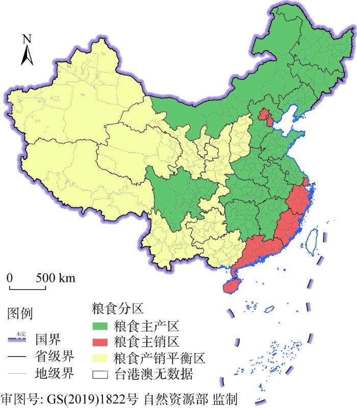
为了综合考虑不同地区间政府政策差异的影响,本文以2006—2020年土地利用总体规划中全国省级政府向市级政府分配的耕地保有量指标为例,对耕地保护指标的空间分配结果和分配策略进行研究。根据中国行政区划,共包括有34个省级行政区(23个省、5个自治区、4个直辖市、2个特别行政区)和333个地级行政区。国家发展改革委员会根据各省级行政区粮食生产与消费的定位,将其划分为粮食主产区、主销区和产销平衡区三类[67](图2)。基于数据的可获得性,选用数据可得的25个省级行政区及其下辖的326个地级及以上城市分别作为省级和市级行政单元的研究对象。山西省和海南省未能获取地级指标分配数据,直辖市内部城区间的耕地指标分配逻辑与省内地市间不可比,因此本文的实证分析均不含这些省市及港澳台地区。样本量充足,涵盖不同粮食分区的省级单元,能综合考虑不同地理区域内耕地保有量指标分配的特征,研究结果具有可参考的意义。
图2
耕地保有量指标数据主要来自自然资源部(
表2 变量描述统计
Table 2
| 变量 | 样本数/个 | 最大值 | 最小值 | 平均值 | 标准差 |
|---|---|---|---|---|---|
| Y耕地保有量指标/(万hm2) | 326 | 221.59 | 0 | 34.3411 | 29.2125 |
| X1人均耕地面积/(hm2/人) | 326 | 0.6318 | 0.0005 | 0.1102 | 0.0894 |
| X2粮食单产/(t/hm2) | 326 | 103.4017 | 0 | 6.6924 | 10.723 |
| X3第一产业占比 | 326 | 0.6403 | 0.002 | 0.1955 | 0.1072 |
| X4农业机械化总动力/万kW | 326 | 1803.9 | 0 | 193.3623 | 216.9522 |
| X5农民人均纯收入/元 | 326 | 9842 | 0 | 3433.6595 | 1447.8468 |
| X6人均水资源拥有量/(万m3/人) | 326 | 147.1226 | 0.0022 | 1.0001 | 8.3305 |
| X7人均GDP/(万元/人) | 326 | 15.1207 | 0.2422 | 1.4351 | 1.3359 |
| X8人均固定资产投资/(万元/人) | 326 | 5.2748 | 0.0936 | 0.6728 | 0.6218 |
| X9第三产业占比 | 326 | 0.6959 | 0.0359 | 0.3669 | 0.0851 |
| X10基期耕地基尼系数 | 25 | 0.8437 | 0.0933 | 0.3207 | 0.1982 |
| X11粮食生产集中度指数 | 25 | 0.0947 | 0.0019 | 0.0378 | 0.0243 |
2 结果分析
2.1 耕地指标分配策略的空间分布特征
2.1.1 粮食分区指标布局差异
从规模布局来看,粮食主产区存在明显的耕地指标规模优势,粮食主销区具有明显的规模劣势,而且这种差异正在逐渐扩大[68]。由图3a的统计结果表明,2005年粮食主产区和主销区的基期耕地分别占总量的68.40%和5.53%,2020年耕地保有量指标占比分别为68.75%和5.40%,与基期相比的变化量分别为0.35%和-0.13%,耕地保有量在主产区的占比增加,在主销区的占比减少。说明粮食生产越来越向主产区集中,以充分发挥主产区的规模生产优势,使其保持粮食生产的核心主导地位,承担更多的粮食保障任务[57,58]。在国土空间规划开发保护新格局中,耕地保护以粮食主产区为核心,不断加强高标准农田建设,稳定提高粮食生产能力,保障粮食安全和粮食产业高质量发展。
图3
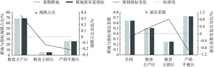
图3
基期耕地与耕地保有量的规模占比和基尼系数
Fig. 3
The scale share and Gini coefficient of cultivated land in the base period and the area of cultivated land reserved
从空间集聚格局来看,粮食主产区呈现出更高的空间集聚性,粮食主销区的空间布局则更加均衡。由图3b和图4的基尼系数和洛伦兹曲线结果可知,无论是基期耕地还是耕地保有量指标,粮食主产区的基尼系数都要高于主销区,主销区的洛伦兹曲线凹度最小。这是由于粮食主产区大规模的集中耕地布局能够促进机械化生产和提升灌溉效率,从而提升耕地利用和粮食生产的效率[68]。在耕地保有量指标分配结果中,粮食主产区和主销区的耕地都呈现出更加明显的集聚化倾向,这是由于在现代农业生产技术不断进步的背景下,这种规模集聚化的生产模式普遍适用于主产区和主销区。在国土空间规划体系中,主销区也能够以促进农业生产集聚的方式,稳步发展产业化和机械化的生产示范基地,建设非粮作物优势区。
图4
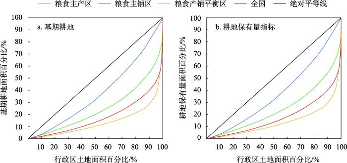
图4
基期耕地与耕地保有量的洛伦兹曲线
Fig. 4
Lorenz curve of cultivated land in the base period and the area of cultivated land reserved
2.1.2 省内指标空间集聚程度
图5
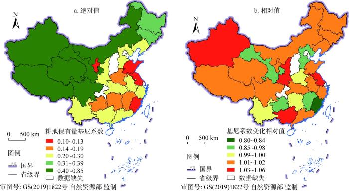
图5
耕地保有量基尼系数绝对值与相对值空间分布
Fig. 5
Spatial distribution of absolute and relative values of the Gini coefficient of the area of cultivated land reserved
图6
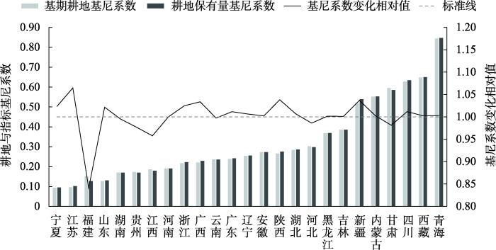
图6
各省级单元耕地保有量指标基尼系数及变化相对值
Fig. 6
Gini coefficients and relative values of changes in the area of cultivated land reserved by provincial units
2.1.3 市级指标空间分配格局
从市级尺度来看,耕地保有量指标的绝对值能够反映至2020年的耕地资源空间配置和规划格局。指标分布最集中于黑龙江的齐齐哈尔市、哈尔滨市、绥化市、佳木斯市和黑河市、吉林的长春市和松原市、内蒙古的呼伦贝尔市和通辽市等粮食主产区省区城市,这9个城市的指标占总量的11.23%。各地区内部指标分布不均,除广西、吉林和辽宁三个地区的指标最集中分布在省会城市,其他省份都集中分布在非省会城市(图7a)。
图7
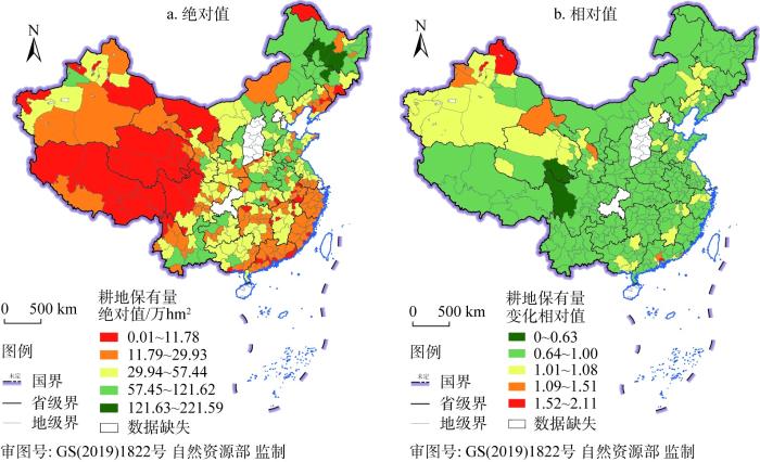
图7
耕地保有量指标绝对值与相对值空间分布
Fig. 7
Spatial distribution of absolute and relative values of the area of cultivated land reserved
耕地保有量指标的相对值是基于2005年基期耕地规模计算所得,其结果能够反映各省份耕地保有量指标的空间分配策略目标(图7b)。在指标分配过程中,若耕地保有量指标相对值大于1,则出现“倒挂型”指标,说明规划期末指标配额超过基期现有的耕地面积;反之则规划期末耕地规模将减小,以促进生态恢复和经济建设等[70]。结果表明,西北地区粮食产销平衡区的新疆、甘肃和青海等地区“倒挂型”耕地指标分布较多,这是由于在耕地生态保护需求之下,规模集聚的农业生产能够促进水资源利用效率提升,充分利用地区的土地和光照资源,促进农业发展,提升粮食产量[69]。此外,“倒挂型”指标也是对地区内各市级单元之间指标的分配调度,在达到耕地总量指标要求的前提下,赋予发达地区更多的土地发展权[3]。在国土空间规划的刚性管控要求下,这种区域间指标调控有助于实现区域资源最佳配置的公平与效率目标。
2.2 耕地指标分配策略的影响因素
2.2.1 全国范围
(1)省际差异检验
本文首先将全国范围内2006—2020年省级土地利用总体规划中向市级单元分配的耕地保有量指标引入空模型中进行估计分析,从而检验模型的适应性。空模型的结果表示(表3),耕地保有量指标分配的组内方差为1.355,组间方差为0.605,组内相关系数ICC为0.309>0.138,组内高度相关,符合模型要求。模型结果说明耕地保有量指标的分配结果确实存在省际差异,不同省份之间的指标分配策略存在差异。
表3 全国范围空模型的估计结果
Table 3
| 空模型 | 固定效应 | 随机效应 | |||||||
|---|---|---|---|---|---|---|---|---|---|
| 参数 | 标准系数β(标准误差) | t值 | 参数 | 标准差 | 方差成分 | χ2 | |||
| Y耕地保有量指标 | γ00 | 3.038(0.166) | 18.28*** | μ0 | 0.778 | 0.605 | 131.82*** | ||
| R | 1.164 | 1.355 | |||||||
注:***表示显著性为1%,下同。
(2)市层级尺度影响因素
市层级随机效应模型说明市级尺度因素能够对耕地保有量指标的分配策略产生影响。模型结果表示(表4),市级尺度的人均耕地面积、第一产业占比、农业机械化总动力、人均GDP和人均固定资产投资都与指标分配显著相关。模型中组内变异缩减比例为(1.355-0.064)/1.355=0.9528,因此随机效应模型中的市级因素能为耕地保有量分配策略的差异解释95.28%。
表4 全国范围市层级模型的估计结果
Table 4
| 随机效应模型 | 固定效应 | 随机效应 | |||||||
|---|---|---|---|---|---|---|---|---|---|
| 参数 | 标准系数β(标准误差) | t值 | 参数 | 标准差 | 方差成分 | χ2 | |||
| γ00 | 3.022(0.175) | 17.22*** | μ0 | 0.893 | 0.797 | 979.62*** | |||
| X1人均耕地面积 | γ10 | 0.886(0.129) | 6.85*** | μ1 | 0.610 | 0.372 | 29.77** | ||
| X2粮食单产 | γ20 | -0.330(0.249) | -1.33 | μ2 | 1.189 | 1.413 | 39.56*** | ||
| X3第一产业占比 | γ30 | -0.381(0.101) | -3.77*** | μ3 | 0.421 | 0.177 | 41.16*** | ||
| X4农业机械化总动力 | γ40 | 0.757(0.057) | 13.20*** | μ4 | 0.258 | 0.066 | 985.41*** | ||
| X5农民人均纯收入 | γ50 | 0.132(0.122) | 1.08 | μ5 | 0.412 | 0.169 | 45.82*** | ||
| X6人均水资源拥有量 | γ60 | -0.033(0.046) | -0.71 | μ6 | 0.208 | 0.043 | 42.29*** | ||
| X7人均GDP | γ70 | -0.242(0.079) | -3.09*** | μ7 | 0.297 | 0.088 | 22.87 | ||
| X8人均固定资产投资 | γ80 | -0.255(0.069) | -3.70*** | μ8 | 0.299 | 0.090 | 31.18** | ||
| X9第三产业占比 | γ90 | -0.092(0.214) | -0.43 | μ9 | 1.020 | 1.041 | 49.40*** | ||
| R | 0.252 | 0.064 | |||||||
注: **表示显著性为5%,下同。
耕地保有量指标的分配与市级尺度耕地资源禀赋的数量显著正相关(β=0.886,P<0.01),而与耕地质量不显著相关(β= -0.330,P>0.10)。现有耕地保有量指标分配策略更倾向于在耕地总量动态平衡政策下对耕地数量进行分配,而对优质耕地资源保护的倾向性较弱。国土空间规划体系要大力发展区域优势农业,形成与耕地资源禀赋相匹配的现代农业生产空间结构布局,严守耕地红线,根据资源环境承载力评价结果,加大优质耕地的集中保护力度,实施耕地质量保护与提升行动[57]。
耕地保有量指标的分配与市级尺度农业发展需求(β= -0.381,P<0.01)和农业生产设施(β=0.757,P<0.01)显著相关,而与农民生活不显著相关(β=0.132,P>0.10)。随着农业现代化的不断发展,农业基础优势较好的地区开展农业规模化和机械化生产,发展区域优势农业,农业基础薄弱地区也能够通过土地整理复垦开发等补充耕地,稳定耕地面积。指标分配策略中对农民收入的偏向性较弱,农民进行农业生产的积极性有所降低,容易发生农业劳动力流失现象,加速耕地撂荒等现象。在国土空间规划体系中,应当对重要农产品优势产区加大耕地保护力度和加强高标准农田建设,提升农业综合生产能力,协调好农业生产、农民生活和农村发展之间的关系,形成现代化农业空间开发格局[58]。
耕地保有量指标的分配与市级尺度生态功能调节不显著相关(β= -0.033,P>0.10)。省级政府在进行指标分配过程中,考虑水资源禀赋的倾向性较弱,部分地区可能由于水资源缺乏而无法满足农业生产,造成生产效率低下、耕地撂荒和土地退化等问题,给耕地资源保护带来压力,并可能对生态环境也造成破坏。在国土空间规划体系中,耕地保护面积与水资源开发规模是重要的生存线,因此需要严格落实水资源刚性约束机制,贯彻“以水定城、以水定地、以水定人、以水定产”与山水林田湖草“生命共同体”理念,统筹水资源与耕地资源的协调开发利用,形成与水土资源相匹配的国土空间格局[46]。
耕地保有量指标的分配与市级尺度建设开发占用的经济水平(β= -0.242,P<0.01)开发投资(β= -0.255,P<0.01)显著相关,而与三产占比不显著相关(β= -0.092,P>0.10)。说明在耕地指标分配过程中,经济发展水平和开发投资更多的市级单元承担更少的耕地保护任务,而容易获得更多的土地发展权,拓展建设用地空间进行开发建设。其中人均GDP变量的随机效应结果不显著,说明各省份都将经济水平作为建设用地开发需求的重要影响因素。在国土空间规划体系中,要合理拓展建设用地新空间和提升土地节约集约利用水平,并根据产业结构调整空间开发结构和国土开发强度,减少建设用地对耕地的占用和严格落实耕地占补平衡制度[71]。
(3)省层级尺度影响因素
省层级截距模型说明省际尺度因素能够引起耕地保有量指标的空间分配策略差异。结果表明(表5),省级尺度中的粮食生产集中度指数对指标分配有显著影响。组间变异缩减比例为 (0.605-0.113)/0.605=0.8132,因此截距模型中的省级因素能为指标分配策略的差异解释81.32%。
表5 全国范围省层级模型的估计结果
Table 5
| 截距模型 | 固定效应 | 随机效应 | |||||||
|---|---|---|---|---|---|---|---|---|---|
| 参数 | 标准系数β(标准误差) | t值 | 参数 | 标准差 | 方差成分 | χ2 | |||
| γ00 | 2.989(0.093) | 32.24*** | μ0 | 0.336 | 0.113 | 46.83*** | |||
| X10基期耕地基尼系数 | γ01 | -0.161(0.171) | -0.94 | ||||||
| X11粮食生产集中度指数 | γ02 | 0.694(0.124) | 5.62*** | ||||||
| R | 1.163 | 1.352 | |||||||
耕地保有量空间分配结果的省际差异与粮食生产区位显著相关(β=0.694,P<0.01),而与耕地空间格局不显著相关(β= -0.161,P>0.10)。粮食生产集中度越高的省份,其承担着全国粮食生产重任,不断推进耕地经营规模化和农业发展产业化,不断提升粮食生产能力,因此这些省份的耕地保护指标分配策略可能会更强调耕地保护与农业发展。基期耕地基尼系数与指标分配不存在显著相关性,说明耕地保有量指标是在基期耕地资源的基础上进行细微的调整,省级耕地资源的地理空间集中或均衡格局并不会过多影响指标的空间分配策略。在国土空间规划体系中,也强调现代化农业生产布局要考虑不同粮食生产区位差异,因地制宜形成与资源禀赋相符合的农业生产结构与区域布局[59]。
(4)省市层级交互作用
表6 全国范围省市层级交互模型的固定效应估计结果
Table 6
| 完整模型 | 固定效应 | ||||
|---|---|---|---|---|---|
| 市级 | 省级 | 参数 | 标准系数β'(标准误差) | t值 | |
| X1人均耕地面积 | γ10 | 0.870(0.103) | 8.48*** | ||
| X11粮食生产集中度指数 | γ12 | -0.450(0.181) | -2.48** | ||
| X2粮食单产 | γ20 | -0.327(0.200) | -1.64 | ||
| X11粮食生产集中度指数 | γ22 | 0.880(0.376) | 2.34** | ||
| X3第一产业占比 | γ30 | -0.385(0.088) | -4.35*** | ||
| X11粮食生产集中度指数 | γ32 | 0.349(0.111) | 3.16*** | ||
| X4农业机械化总动力 | γ40 | 0.761(0.057) | 13.30*** | ||
| X11粮食生产集中度指数 | γ42 | 0.112(0.058) | 1.92* | ||
| X5农民人均纯收入 | γ50 | 0.014(0.116) | 0.12 | ||
| X11粮食生产集中度指数 | γ52 | 0.154(0.144) | 1.07 | ||
| X6人均水资源拥有量 | γ60 | -0.029(0.040) | -0.72 | ||
| X11粮食生产集中度指数 | γ62 | 0.130(0.049) | 2.67** | ||
| X7人均GDP | γ70 | -0.246(0.072) | -3.40*** | ||
| X8人均固定资产投资 | γ80 | -0.227(0.060) | -3.77*** | ||
| X11粮食生产集中度指数 | γ82 | 0.184(0.075) | 2.47** | ||
| X9第三产业占比 | γ90 | -0.116(0.158) | -0.73 | ||
| X11粮食生产集中度指数 | γ92 | 0.750(0.306) | 2.45** | ||
注:*表示显著性为10%,下同。
表7 全国范围省市层级交互模型的随机效应估计结果及方差变化情况
Table 7
| 完整模型 | 随机效应 | 方差变化/% | |||
|---|---|---|---|---|---|
| 参数 | 标准差 | 方差成分 | χ2 | ||
| μ0 | 0.496 | 0.246 | 688.72*** | -69.08 | |
| X1人均耕地面积 | μ1 | 0.469 | 0.220 | 27.22* | -40.99 |
| X2粮食单产 | μ2 | 0.869 | 0.756 | 87.25*** | -46.53 |
| X3第一产业占比 | μ3 | 0.348 | 0.121 | 40.50*** | -31.61 |
| X4农业机械化总动力 | μ4 | 0.250 | 0.063 | 1024.07*** | -5.87 |
| X6人均水资源拥有量 | μ6 | 0.174 | 0.030 | 42.19*** | -29.68 |
| X8人均固定资产投资 | μ8 | 0.189 | 0.036 | 28.52** | -59.99 |
| X9第三产业占比 | μ9 | 0.714 | 0.510 | 37.87*** | -50.96 |
| R | 0.253 | 0.064 | 0.46 | ||
粮食生产集中度指数越高的省份,指标分配对于耕地数量集聚的指向性有所减弱,而更偏向高质量耕地集聚、更具有农业生产基础优势的市级单元,且更关注水资源承载能力限制和约束建设用地开发对耕地的占用[59]。通过交互作用,省级粮食生产集中度指数削弱了人均耕地面积对指标分配的正向影响(β'= -0.450,P<0.05),削弱了第一产业占比的负向影响(β'=0.349,P<0.01),增强了农业机械化总动力的正向影响(β'=0.112,P<0.10),削弱了人均固定资产投资的负向影响(β'=0.184,P<0.05)。上述变量的随机效应方差分别减少了40.99%、31.61%、5.87%和59.99%,说明交互作用能够解释这些影响因素部分的省际差异。尽管粮食单产、人均水资源拥有量和第三产业占比本身与指标分配不显著相关,但都存在正向的交互效应(β'=0.880,P<0.05)(β'=0.130,P<0.05)(β'=0.750,P<0.05),且交互作用下变量方差分别减少了46.53%、29.68%和50.96%,由此可见粮食生产大省对耕地质量、水资源保护和减少建设占用耕地的偏向性。交互作用使得指标分配策略存在异质性,原本建设开发机会更多的区域也要承担相对更多的耕地保护责任,一方面能够保护优质耕地不被建设用地侵占,另一方面也能够促进粮食生产大省更好地达到耕地保护和粮食生产的目标。
2.2.2 不同粮食分区差异
对粮食主产区和主销区分别进行影响因素分析,能够进一步解释不同粮食生产战略区位内耕地保有量指标分配策略的差异。空模型的结果表明,粮食主产区耕地保有量指标分配的组内方差为0.789,组间方差为0.065,组内相关系数ICC为0.076<0.138,组内相关度较低;粮食主销区耕地保有量指标分配的组内方差为0.790,组间方差为0.007,组内相关系数ICC为0.009<0.138,组内相关度也较低。模型结果说明粮食主产区和主销区各自内部不同省份之间的指标分配策略存在相似性,不存在省际尺度因素和交互作用影响差异,因此只做市级尺度的影响因素分析,通过主产区与主销区结果对比得到粮食分区的指标分配策略差异。
市层级随机效应模型结果说明(表8),农业机械化总动力在粮食主产区和主销区都与耕地保有量指标分配存在显著相关性,而人均耕地面积、第一产业占比、人均GDP、人均固定资产投资和第三产业占比明显在粮食主产区存在更高的相关性。农业机械化总动力在不同粮食分区都能够影响耕地保有量指标的分配,说明农业机械化生产已经成为全国范围内普遍的耕地生产目标,能够在有限的耕地空间上获得更多的粮食产量,提升耕地的集约利用效率,形成规模化生产和集约化经营的农业发展格局。与粮食主销区相比,人均耕地面积和第一产业占比仅与粮食主产区指标分配相关(β=0.665,P<0.01;β= -0.208,P<0.05),说明粮食主产区比主销区更强调区域的耕地资源禀赋基准和农业发展需求,侧重于农业规模化生产的倾向。人均GDP和人均固定资产投资也仅与粮食主产区指标分配相关(β= -0.236,P<0.01;β= -0.146,P<0.01),说明粮食主产区在保护耕地和输出粮食的战略定位下,更加需要平衡好耕地与建设用地的空间竞争。第三产业占比也仅与粮食主产区指标分配相关(β=0.441,P<0.01),但与预测相关性系数相反,这是因为与第二产业相比,第三产业的建设用地占用耕地相对较少,更有潜力提升建设用地的利用效率,因此可以分配更多的耕地保有量指标。由此可见,耕地保有量指标分配策略在粮食主产区和主销区存在差异。在国土空间规划体系中,粮食主产区不断打造特色化粮食生产核心区,强化粮食供给保障能力;主销区更加侧重建设机械化生产基地,并提升非粮作物产业基地竞争力等[57⇓-59]。
表8 粮食主产区和主销区市层级模型的估计结果
Table 8
| 随机效应模型 | 参数 | 粮食主产区固定效应 | 粮食主销区固定效应 | |||
|---|---|---|---|---|---|---|
| 标准系数(标准误差) | t值 | 标准系数(标准误差) | t值 | |||
| γ00 | 3.430(0.096) | 35.72*** | 2.486(0.134) | 18.58*** | ||
| X1人均耕地面积 | γ10 | 0.665(0.059) | 11.23*** | 0.964(0.589) | 1.64 | |
| X2粮食单产 | γ20 | 0.059(0.174) | 0.34 | -0.829(0.938) | -0.89 | |
| X3第一产业占比 | γ30 | -0.208(0.071) | -2.95** | -0.231(0.291) | -0.79 | |
| X4农业机械化总动力 | γ40 | 0.859(0.028) | 30.72*** | 0.703(0.121) | 5.81*** | |
| X5农民人均纯收入 | γ50 | 0.181(0.206) | 0.88 | 0.379(0.354) | 1.07 | |
| X6人均水资源拥有量 | γ60 | 0.046(0.036) | 1.29 | 0.297(0.173) | 1.72 | |
| X7人均GDP | γ70 | -0.236(0.069) | -3.41*** | 0.219(0.313) | 0.70 | |
| X8人均固定资产投资 | γ80 | -0.146(0.041) | -3.61*** | -0.243(0.211) | -1.15 | |
| X9第三产业占比 | γ90 | 0.441(0.140) | 3.14*** | -0.321(0.759) | -0.42 | |
3 结论与讨论
3.1 结论
耕地保护指标是对耕地规模底线进行约束性管控的关键空间规划政策工具,对国家粮食战略安全和经济可持续发展具有重要意义。本文以全国2006—2020年省级土地利用总体规划中耕地保有量指标的分配结果为例,分析不同粮食分区耕地保有量指标的空间分配特征,构建理论分析框架和运用多层线性模型探究不同政府层级影响因素及交互作用,能够为现有的耕地保护指标分配和空间规划体系提供可借鉴的意义。主要研究结论如下:
(1)耕地保有量指标规划调控策略存在空间差异。粮食主产区具有耕地规模生产优势和集聚分布格局,指标分配在空间上呈现出西北地区更集聚、东南地区更均衡的格局。“倒挂型”指标能够体现省级总量指标要求下的地区间指标分配调度,促进部分地区农业生产规模集聚,并赋予其他地区更多的土地发展权,实现区域资源最佳配置的公平与效率目标。
(2)耕地保有量指标分配策略对耕地保护责任和土地发展权进行规划权衡。耕地资源和农业生产设施更丰富的市级单元容易承担更多的耕地保护任务,以促进耕地适度规模化生产;经济水平更高和开发投资更多的市级单元承担更少的耕地保护任务,以规划适度的土地发展权,但要注意约束建设用地的过度扩张。此外,指标分配的过程中可能对于耕地质量、水资源和农民收入等考虑不足,可能会加速优质耕地流失、水资源短缺和农民撂荒等问题。
(3)不同粮食分区的指标分配策略存在差异。在交互作用下,粮食主产区省份更具有保护优质耕地和水资源、提升农业生产规模优势和控制建设用地占用耕地的分配导向,以承担耕地保护和粮食生产的战略任务;粮食主销区省份更具有机械化生产的集约分配导向,加强非粮作物优势生产基地建设等。
3.2 讨论
上一轮土地利用总体规划在制定时面临着土地利用和管理的严峻挑战,耕地保护与建设用地的供需矛盾十分突出,因此其实行最严格的土地管理制度,坚持严格保护耕地和节约集约用地的指导方针,围绕18亿亩耕地红线设置耕地保有量指标,严格控制非农建设用地占用耕地。从本文研究的指标分配结果中可以发现,耕地保有量指标分配过程具有经营规模化和生产机械化导向,但由于耕地保护空间与优质耕地和水资源空间的错配,容易产生优质耕地流失和农田灌溉水资源不足等问题。国土空间规划是将主体功能区规划、土地利用规划和城乡规划等空间规划融合为统一的规划体系,其继承和发展了原有土地利用总体规划的规划指标,并希望构建一个“多规合一”后多目标协同的规划指标体系。在国土空间规划背景下,耕地保护指标继续沿着“五级三类”的规划框架进行“自上而下”的传导,指标分配将进一步依托资源环境承载力评价和国土空间开发适宜性评价结果展开。“双评价”结果能够帮助科学认知自然地理国情和区域发展格局演变规律,以“一张图”的方式衔接各级规划,应对耕地保护指标与资源禀赋空间错配的问题,使指标分配结果更加具有科学性和有效性[24]。在此基础上,耕地保护指标分配经过省级政府与市级政府之间理性权衡的博弈过程,平衡区域内资源配置的公平与效率目标,构建高效协调可持续的国土空间开发格局[72]。
综上所述,本文提出以下政策建议:(1)耕地保护指标分配应当继续坚持适度规模化经营导向,以促进农业生产要素投入,提升耕地的集约利用效率,充分发挥规模经济效益[43]。(2)不同粮食分区应当立足资源禀赋基础,充分发挥区域比较优势[57]。粮食主产区、主销区和产销平衡区的上级政府应当结合基期现状和未来发展目标,综合考虑规划导向和可执行程度,因地制宜调整适合的规划指标分配策略,促进规划政策执行落实。(3)探索建立粮食主销区向主产区的横向利益补偿机制,各粮食分区之间形成协调关联的粮食生产网络空间[58,59]。粮食主产区承担更多的耕地保护指标和粮食生产任务,保障向主销区和产销平衡区的粮食输出,但也牺牲了很多经济发展机会;粮食主销区可以适当地将部分耕地保护指标转移给主产区,但要完善向主产区的利益补偿政策,引导主销区企业参与主产区粮食生产基地建设,从“供需合作”向“供应链合作”转型,形成现代化粮食产销合作新格局,实现粮食安全与经济发展的双赢[73⇓-75]。
本文以土地利用规划中耕地保有量指标的分配结果为例,旨在建立一个综合地区空间差异和政府层级博弈的耕地保护指标分配体系,为国土空间规划指标体系构建提供借鉴意义。但本文研究尚存在一定局限性,并未探讨除耕地保有量指标之外的其他耕地保护指标分配策略的差异,例如基本农田保护面积指标更加强调优质耕地的保护,新增建设用地占用耕地指标更加强调耕地与建设用地之间的占补问题等,结合不同指标之间的一致性与差异性将更有助于构建综合的耕地保护指标体系。此外,除耕地保有量等刚性约束管控指标之外,指标分配体系中也存在部分弹性指标,并通过耕地占补平衡政策、城乡建设用地增减挂钩政策、土地发展权转移交易政策等实现“刚弹并济”的指标配置,关于这些弹性指标政策在指标分配和执行过程中所发挥的作用,也需要未来进一步的研究与探索。
参考文献
中国耕地保护政策运行效果分析
Analysis on the effect of policies operation of cultivated land protection in China
Cultivated land use change in China, 1999-2007: Policy development perspectives
DOI:10.1007/s11442-012-0983-5
[本文引用: 1]

<p>Cultivated land protection (CLP) entered the new era of macro administration in 1999 in China. This paper presents a holistic analysis of cultivated land use change concerning the three goals of the CLP, i.e., grain security, ecological security and harmonizing regional development. Farmers’ willingness to grow grain has been the key factor in safeguarding grain security. Grain-for-green policy has contributed to improving ecological state especially in the western provinces. Effects of the land macro-control of the CLP on harmonizing regional development were significant. Moreover, cultivated land use change in 1999-2007 points out the way of the evolving policy in the future. From the viewpoint of normative concept of multifunctionality, we discuss development of the three land functions, i.e., production function, environmental function and carrier function. Finally, we propose to emphasize multifunctional land management based on regional differences to promote transition of the CLP.</p>
中国耕地占补平衡政策的成效与局限
Effectiveness and limitations of cultivated land requisition-compensation balance policy in China
Impact of urbanization on cultivated land changes in China
DOI:10.1016/j.landusepol.2015.01.007 URL [本文引用: 1]
Urban expansion in China and its effect on cultivated land before and after initiating "Reform and Open Policy"
DOI:10.1007/s11430-015-0160-2 URL [本文引用: 1]
Assessing farmland protection policy in China
DOI:10.1016/j.landusepol.2006.01.005 URL [本文引用: 1]
Review of the evolution of cultivated land protection policies in the period following China's reform and liberalization
DOI:10.1016/j.landusepol.2017.07.012 URL [本文引用: 1]
Impact of the top-down quota-oriented farmland preservation planning on the change of urban land-use intensity in China
DOI:10.1016/j.habitatint.2017.12.013 URL [本文引用: 1]
中国耕地保护制度 70 年: 历史嬗变, 现实探源及路径优化
Cultivated land protection system in china form 1949 to 2019: Historical evolution, realistic origin exploration and path optimization
Land use change and economic growth in urban China: A structural equation analysis
DOI:10.1177/0042098013513649
URL
[本文引用: 1]
Land use change is not only the consequence of economic growth but also its direct and indirect driver. Based on official land use change data from 2004 to 2008, this study found substantial land use changes in China, with considerable cultivated land conversion into urban, industrial and transportation purposes. Correlation analysis shows a strong association between land use change and absolute GDP expansion. Structural equation analysis indicates that economic growth drives land use change. Industrial land expansion directly stimulates economic growth. Land has been successfully used as a tool to attract foreign investments and to sustain infrastructure investments, indirectly triggering economic growth. The findings suggest that land is not a simple factor of production but a strategic tool for economic development in urban China.
Land use transitions and land management: A mutual feedback perspective
DOI:10.1016/j.landusepol.2017.03.021 URL [本文引用: 1]
从城乡规划到国土空间规划
On the transformation from urban and rural planning to territory development planning
以目标和问题为导向构建规划指标体系: 市级国土空间总体规划指标体系构建探索
A goal-oriented and problem-oriented approach of creating planning indicator matrix: Exploring the path to establish goals of the territorial planning at a municipal level
“多规合一” 与空间规划: 认知, 导向与路径
Cognition, direction and path of future spatial planning based on the background of multiple planning integration
Cultivated land protection policies in China facing 2030: Dynamic balance system versus basic farmland zoning
DOI:10.1016/j.habitatint.2017.09.002 URL [本文引用: 1]
中国国土空间用途管制的基础性问题思考
Rethinking on the basic issues of territorial and spatial use control in China
统一国土空间用途管制制度的思考
DOI:10.31497/zrzyxb.20191015
[本文引用: 1]
近年来,统一国土空间用途管制,已提升到前所未有的国家战略部署层面,是一项带有全局意义的极其重要的改革任务。在系统梳理1949年以来国土空间用途管制制度演变的基础上,重点总结中国以往国土空间用途管制的主要特点,结果发现:贯彻落实用途管制制度,关键是把握好规划编制、实施许可、监督管理三大环节,统筹陆域、海域两类国土空间,差别化管理建设与非建设两种活动。结合制度建设的前提,提出构建统一国土空间用途管制制度的建议:(1)建立统一的国土空间用途管制控制线体系;(2)构建丰富有效的国土空间用途管制手段体系;(3)确立统一明晰的国土空间用途管制监管体系;(4)完善国土空间用途管制的相关法律法规体系。
Thoughts on unifying the regulation of territorial space use
DOI:10.31497/zrzyxb.20191015
[本文引用: 1]
In recent years, the unification of territorial space use regulations has been upgraded to an unprecedented level of national strategic deployment, which is an extremely important reform task with overall significance. Based on the systematical review on the institutional evolution of territorial space use regulation since 1949, this paper puts an emphasis on summarizing the major features of previous territorial space use regulations in China. In general, we conclude that the key to implement territorial space use regulations is to control the three important aspects which consist of planning, licensing and supervision, to coordinate the utilization of continental space and ocean space and to discriminate the management of construction and non-construction purposes. On the premise of system construction, we propose four suggestions to institution on how to unify the territorial space use regulations: (1) Establishing a unified control line system for territorial space use regulations at the planning level; (2) Building an abundant and effective measure system for territorial space use regulations; (3) Constructing a unified and explicit regulatory system for territorial space use regulations at the supervision level; (4) Improving the legal system to help territorial space use governance at the support level.
中国规划空间管制的评价
Assessment of spatial planning and management of china's planning
土地的区域间配置与新发展格局: 基于量化空间均衡的研究
Spatial allocation of land and new development pattern: Baesd on the analysis of quantitative spatial equilibrium
Discussion on evolution of land-use planning in China
基于基尼系数的耕地保有量分配优化模型
Optimization model for cultivated land allocations based on the gini coefficient
DOI:10.2307/141984 URL [本文引用: 1]
国土空间规划的规制效率及溢出效应研究进展
State of art on the regulatory efficiency and spillover effects of the spatial planning
国土空间规划管制与区域经济协调发展研究: 一个分析框架
DOI:10.11849/zrzyxb.20160789
[本文引用: 1]
厘清国土空间规划管制与区域经济协调发展之间的关系,是我国国土空间规划管制有效开展的重要前提。论文主要结合国内外最新的实证研究文献,在国土空间规划管制对区域经济协调发展影响的“表现形式—作用机理—协调机制”这一逻辑框架下,分析了国土空间规划管制与区域经济协调发展的关联机理。研究结果表明:1)国土空间规划管制影响区域经济协调发展主要表现在发展受限制区域的土地产权受到抑制和资源环境保护的外部性未能有效地内在化;2)国土空间规划管制影响区域经济协调发展的作用机制在于保护型区域生产的生态产品可贸易性较差,使其落入比较优势陷阱;3)国土空间规划管制下的区域经济协调机制主要包括土地发展权漂移、税费调节和地役权保护。从理论和实践上来看,空间规划管制从诞生起,就面临效率的争议,但在资源环境保护的巨大压力之下,国土空间规划管制在实践层面又非不可调和,关键在于区域经济协调机制的设计。这对我国在建立“多规合一”的国土空间规划体系的时代背景下,为避免新的区域经济协调发展问题具有重要的政策含义。
Research on spatial regulation of land use plannning and coordinated development of regional economy: An analytical framework
国土空间用途管制的改革逻辑及其规划响应路径
DOI:10.31497/zrzyxb.20200601
[本文引用: 2]
在完善生态文明制度体系、推进国家治理体系和治理能力现代化的宏观背景下,系统梳理土地用途管制制度起源、实施特点、成效与不足,重点解析土地用途管制向国土空间用途管制转型的改革逻辑及其对国土空间规划的具体要求,为完善国土空间规划体系提供借鉴。研究结果表明:(1)土地用途管制制度突出强调对耕地的保护,以新增建设用地为主要管控对象,建立了土地用途分类—规划—计划—审批—监管的完整管控链条,在保护耕地、保障粮食安全、倒逼节约集约用地和提高依法依规用地意识等方面取得了较好成效,但仍存在覆盖范围不全、管制刚性过强、生态用地管制乏力等不足。(2)国土空间用途管制以生态文明建设为逻辑起点,通过单一地类保护向空间统筹转型、地类管制向空间管控转型、指标传导为主向指标与分区相结合转型、底线约束向约束与引导并重转型,构建面向全过程、多样化的管制规则体系,完善空间传导机制,进而实现所有国土空间全要素统一管制。(3)面对国土空间用途管制的时代需求,国土空间规划改革应在系统性、整体性的规划管控指标体系、覆盖全域、上下衔接的规划分区体系、底线约束与激励引导相结合的规划实施弹性机制以及“全链条”管理机制等方面做出积极响应,进而实现不同层级国土空间规划和用途管制的统筹协调管控。
Reform logic of territorial space use regulation and the response path of land spatial planning
DOI:10.31497/zrzyxb.20200601 URL [本文引用: 2]
省级基本农田数量确定与指标分解方法初探
Approach to determination and allocation of prime farmland in provincial land use planning
耕地保护与基本农田布局方法研究: 以济南市为例
The method research of cultivated land protection and basic farmland distribution: Taking Jinan for example
改进熵权系数法在基本农田指标分解中的应用
Application of advanced entropic coefficient method to distribute basic farmland guideline
基本农田保护指标分解研究: 以湖北红安县为例
Study on the decomposition of basic farmland protection indicators: Taking Hong'an county of Hubei province as an example
Assessing spatial uncertainties of land allocation using a scenario approach and sensitivity analysis: A study for land use in Europe
DOI:10.1016/j.jenvman.2012.08.038 URL [本文引用: 1]
Construction land expansion and cultivated land protection in urbanizing China: Insights from national land surveys, 1996-2006
DOI:10.1016/j.habitatint.2014.10.019 URL [本文引用: 1]
云南省土地利用总体规划耕地保有量指标合理性分析
Analyzing the reasonability of the minimum amount of cultivated land within the general land use planning in Yunnan province
Can the land use master plan control urban expansion and protect farmland in China? A case study of Nanjing
DOI:10.1111/grow.2018.49.issue-3 URL [本文引用: 1]
Farmland preservation policies in China and their impacts on urban expansion: A multilevel analysis
DOI:10.1080/09640568.2021.1876000 URL [本文引用: 1]
中国土地利用总体规划实施中主要问题及成因分析
Analysis of problems and causes in the implementation of comprehensive land use planning in China
中央政府与地方政府在土地垂直管理制度改革中的利益博弈分析
Analysis on the benefit game between central and local governments in the reform of direct top-dowm land administration system
Decentralization in a centralized system: Project-based governance for land-related public goods provision in China
DOI:10.1016/j.landusepol.2015.04.025 URL [本文引用: 1]
Land-use changes and policy dimension driving forces in China: Present, trend and future
DOI:10.1016/j.landusepol.2011.11.010 URL [本文引用: 1]
国土空间规划的多目标协同治理机制
Multi-objective collaborative governance mechanism of territorial space planning
土地发展权与国土空间规划: 治理逻辑、政策工具与实践应用
Land development rights and territorial spatial planning: Governance logic, policy tools and practical applications
新时期国土空间治理的价值传导与目标演进: 市县国土空间规划指标体系的响应
DOI:10.13284/j.cnki.rddl.003359
[本文引用: 1]
基于对国土空间及空间规划内涵的梳理分析,深入剖析新时期国土空间治理的内在价值传导关系,探讨面向高质量发展的市县国土空间总体规划指标体系构建逻辑。研究认为:1)国土空间规划目标与国土空间治理指标之间有着严密的价值传导关系,不同层级政府的战略目标和空间治理理念在传递中分化衍变,导致规划指标体系在关注对象、控制性、统筹性等方面的差异;2)市县国土空间总体规划指标体系的建构,需要基于价值传导和指标控制的协同,以及基于战略目标导向和国土空间治理的统筹,成为规划导向落实的重要抓手;3)多规并行时代的规划指标体系构建共识正在打破重组,构建面向高质量发展的规划指标体系需要认清国土空间规划的战略性和基础性作用,对国家战略的逐级落实和国土空间治理能力提升做出响应。
Value transmission and goal evolution of territorial spatial governance in the New Era: Response of the territorial spatial planning index system at the city and county scale
DOI:10.13284/j.cnki.rddl.003359
[本文引用: 1]
Through the establishment of the territorial spatial planning system, the logic of territorial spatial governance in the new era has gradually become clear, with ecological civilization construction as the strategic guidance, five development concepts(innovative, coordinated, green, open and shared development concept) as the ideological guidance, and territorial spatial planning as the basic tool. Based on the implications of territorial spatial and spatial planning, this study analyzed the internal value transmission relationship under territorial spatial governance and explored the logic of the general territorial spatial planning index system at the city and county scale required to meet high-quality development. Three main points regarding strategies to enhance territorial spatial planning were highlighted in this study. First, there is a strict internal transmission relationship between spatial planning goals and governance indicators. At present, territorial spatial governance for high-quality development faces complex problems. The government's multi-level strategic objectives and spatial governance concepts differentiate and evolve during the transmission, which leads to differences in the planning index system with respect to aspects such as attention, control, and overall planning. The guidance and control of planning implementation through planning indicators at all levels helps to achieve development goals and manage spatial issues. Second, the development of the index system for general territorial spatial planning at city and county scale requires not only the transmission of top-down hierarchical management and spatial governance for specific problems but also the exertion of index control based on constraints and expectations. Additionally, the index system also needs to consider the supporting role of new urbanization, rural revitalization, marine economy, ecological civilization, and other strategic objectives. Simultaneously, we should grasp the boundaries of developmental, regional, and spatial planning; carry out classified management around the territorial spatial using control objectives; and increase the proportion of spatial indicators in the index system. Third, the consensus on the planning index system in the era of multi-planning parallelism is to break down and reorganize. To build a planning index system for high-quality development, we need to recognize the strategic and fundamental roles of territorial spatial planning and respond to the incremental implementation of national strategies and improvement in the ability of territorial spatial governance. Under different resource endowments with different strategic development layouts and social and economic development stages, relying on the evolving logic of the index system will facilitate the development of a more practical planning index system with unified implications and provide support for the compilation, implementation, supervision, investigation, and evaluation of territorial spatial planning in the new era.
中国耕地供需变化规律研究
Study on changing relationship of demand and supply of cultivated land in China
The effects of China's cultivated land balance program on potential land productivity at a national scale
DOI:10.1016/j.apgeog.2013.11.009 URL [本文引用: 1]
中国省际耕地利用效率时空格局分异与机制分析
Spatial-temporal pattern differentiation and its mechanism analysis of using efficiency for provincial cultivated land in China
中国耕地集约利用研究现状及趋势分析
Present situation and trends in research on cultivated land intensive use in China
Grain production space reconstruction and land system function tradeoffs in China
DOI:10.1016/j.geosus.2021.02.003 URL [本文引用: 1]
水土资源匹配视角下中国省域农产品供需平衡分析及其政策启示
DOI:10.31497/zrzyxb.20210617
[本文引用: 2]
粮食安全关系到中国稳定与发展和国际贸易秩序。以省级行政区为基本单位,基于2016—2018年各省份常住人口、农产品消费量、农业数据及相关参数,采用生态足迹和水足迹评价方法,在只考虑食用和再生产消费且不考虑地区耕地质量差异的条件下,核算各省份农产品自给的水土资源需求,评价中国省域水土资源承载力状态。结果显示:(1)中国现有耕地资源总量可满足自身耕地总需求(前者是后者1.81倍),但省际差异大,东部沿海省市耕地不足。(2)农业可用水资源总量亦可满足农业可持续生产需求,但区域严重不平衡,华北平原与宁夏水资源赤字严重,而青藏高原地区、长江以南省份农业可用水资源丰富。(3)水土资源空间不匹配制约了中国农业的粮食生产潜力,不考虑环境净化用水,水土资源匹配状态可满足全国粮食自给需求;但考虑环境净化用水,中国粮食难以实现自给,承载力赤字达33715.50万人。以资源环境可持续为导向,未来中国应从农业生产布局优化、农业结构调整、农业科技、产业与人口转移、农产品进口和农业国际合作等方面着手,解决中国农产品需求问题。
Analysis of supply-demand balance of agricultural products in China and its policy implication
DOI:10.31497/zrzyxb.20210617 URL [本文引用: 2]
耕地资源动态变化及其影响因素分析
Study on dynamic change of cultivated land resources and causes of the changes
The impact of urban expansion on agricultural land use intensity in China
DOI:10.1016/j.landusepol.2013.04.011 URL [本文引用: 1]
一种融合地理空间指标的土地需求量预测方法: 以佛山市南海区为例
A method to forecast land demand by fusing geo-spatial indicators exemplified by Nanhai in Foshan
基于不同尺度的中国区域经济差异
DOI:10.11821/xb201208007
[本文引用: 1]
采用变异系数、泰尔指数、空间自相关和尺度方差等统计方法从地带、省级、地级和县级4 个尺度对1998-2009 年中国区域经济差异进行测度和空间格局比较分析。① 差异测度研究表明, 自1998 年以来, 中国区域经济差异在4 个尺度上均表现出扩大的趋势;省级、地级和县级单元人均GDP具有显著的空间自相关性, 其中地级和县级人均GDP的空间自相关程度呈扩大趋势。② 尺度方差及其分解研究表明, 尺度方差及其构成大小依次排列均为县级、地级、省级、地带, 即尺度越小, 尺度方差越大, 对区域经济差异的贡献份额也越大。③ 空间格局研究表明, 不同尺度区域经济空间关联格局总体相对稳定, HH类型集聚区大多分布于东部沿海地区, LL类型在中西部地区的大规模集聚是不同尺度区域经济空间自相关性的主要原因;各尺度显著空间关联类型对总体空间自相关和区域经济差异的影响各不相同。
Regional inequalities in china at different scales
DOI:10.11821/xb201208007
[本文引用: 1]
Analyzing regional inequality is of great significance to both academic enquiry and government policy. The recent literature on economic geography implies that scale has been playing a significant role in the economic geographical processes. Although regional inequality in China has also attracted tremendous scholarly interests since China started to implement policies of economic reforms in the late 1970s, the current work ignores the scalar effects in studying the regional inequality. With the increasing availability of data, this paper employs Coefficient Variance, Theil Index, spatial autocorrelation and scale variance based on the per capita GDP to examine the changing trends and spatial patterns of regional inequalities in China at four different spatial scales, i.e. region, province, prefecture and county. First, we use CV, Theil Index and Moran's I to explore the changing trends of regional inequalities in China and find that they all experienced increasing regional inequalities and significant spatial autocorrelation in regional development at all the four scales. Both of the prefecture and county levels have experienced a process of intensifying spatial autocorrelation. Second, with the scale variance and its component statistic techniques, we discover that there is an increasing sequence according to the scale variances and their components, i.e. county, prefecture, province and region, which indicates that the scalar variance is lower at the smaller scale and the regional inequality at smaller scale contributes more to the whole regional inequality. Third, by using spatial analysis techniques, we find that local spatial autocorrelation patterns have been stable since 1998. The HH type units tend to concentrate in the east coastal area of China. And the significant spatial autocorrelation is largely due to the concentration of LL clusters in central and western China. This paper also concludes that the regional inequality in China merits more investigation at the county level as the county unit is the most stable one in the history of China's regional administrative system.
中国主体功能区划方案
DOI:10.11821/dlxb201502002
[本文引用: 1]
中国主体功能区划方案是刻画未来中国国土空间开发与保护格局的规划蓝图,主体功能区规划已上升为主体功能区战略和主体功能区制度。2004-2014年,笔者组织系列研究项目,配合国家编制主体功能区规划,研究地域功能基础理论和功能区划技术流程,提出国家和省区尺度进行空间管制的地域功能区域类型为城市化区域、粮食安全区域、生态安全区域、文化和自然遗产区域等4类,在此基础上转化为以县级行政区划为单元的优化开发、重点开发、限制开发和禁止开发4类主体功能区。研制了由水资源、土地资源,生态重要性、生态脆弱性、环境容量、灾害危险性、经济发展水平、人口集聚度和交通优势度等9类可定量指标及战略选择为1项定性指标构成的地域功能识别指标体系,进行了单项指标评价,开发并运用地域功能适宜程度综合评价指数进行了综合评价,测算了各省区保护类区域下限、开发类区域上限以及开发强度等关键参数;研讨了以规划为应用指向的主体功能区划分方法,形成中国首部主体功能区划方案,按照全国主体功能区规划口径,2020年与2010年相比,全国国土空间开发强度从3.48%增加到3.91%;按照省区集成的主体功能区规划口径,优化、重点、限制开发区域的土地面积比重分别为1.48%、13.60%、84.92%,城市化、粮食安全、生态安全区域的土地面积比重分别为15.08%、26.11%、58.81%。结合区域发展水平、资源环境承载状态、民生质量等相关分析,给出了主体功能区的主要特征。通过区划方案校验,国家和省区分两级采用笔者主持制定的《主体功能区划技术规程》互动完成的全国主体功能区划方案,同预判的吻合程度多为80%以上。
Draft of major function oriented zoning of China
DOI:10.11821/dlxb201502002
[本文引用: 1]
Major Function Oriented Zoning (MFOZ) is the blueprint for the future developmnt and protection pattern of China's territory, and has been raised to from major function zones planning to major function zoning strategy and major function zoning institution. From 2004 to 2014, the author organized a series of research projects to compose MFOZ for the country, studied basic theory of regional function and MFOZ technical process, and proposed that space controlling zones of national and provincial scales can be divided into four types: urbanized zones, foodstuff-security zones, ecological safety zones, cultural and natural heritage zones. On this basis, major function zones of county scale should be transferred to optimized, prioritized, restricted, and prohibited zones. In this paper, a regional function identification index system comprising nine quantitative indicators (including water resources, land resources, ecological importance, ecological fragility, environment capacity, disaster risk, economic development level, population concentration and transport superiority) and one qualitative indicator of strategic choice is developed. Based on the single index evaluation, comprehensive evaluation using regional function suitability evaluation index is conducted, aiming at testing several key parameters including lower limit of protection zones and upper limit of development zones at the provincial level. In addition, a planning-oriented zoning method of major function zones is also discussed, which has brought the first MFOZ planning in China. According to the MFOZ caliber, it is forecasted that national spatial development intensity will rise from 3.48% in 2010 to 3.91% in 2020. Furthermore, according to caliber of the provincial integrated MFOZ planning, the area of optimized, prioritized and restricted zones accounts for 1.48%, 13.60% and 84.92%, respectively, and that of urbanized, foodstuff-security and ecological safety zones accounts for 15.08%, 26.11% and 58.81%, respectively. In combination of analyses of development level, resources and environmental carrying status and quality of the people's livelihood, the main characteristics of MFOZ were identified. Through verification, MFOZ draft of national and provincial scales, which is interactively accomplished with "MFOZ Technical Process" put forward by the author, is mostly above 80% identical with what have been forecasted.
年中国耕地资源安全评价
Evaluation for cultivated land resources security of China in 2007
DOI:10.11820/dlkxjz.2011.11.016
[本文引用: 1]
14 indexes about quantity security, quality security and ecological security were selected to evaluate the cultivated land resources security (CLRS) of China in 2007. The data were derived from the land use survey and the reports of agricultural land classification from the Ministry of Land and Resources of China, the Second National Soil Survey (1978) and National Bureau of Statistics of China. The results can be concluded as follows. (1) the CLRS of China is not high in 2007 with a score of only 0.517. Among the four regions, the evaluation value of CLRS is higher in eastern China but lower in western China. At provincial level, the scores of CLRS of Xinjiang and Tibet in Western China and 10 provinces of eastern China, such as Shandong, Fujian, Zhejiang, is higher than those of the others. Provinces with lower scores of CLRS are mostly distributed in Western China, including Shaanxi, Inner Mongolia, Gansu, Qinghai, and Ningxia. (2) The quantity security score of CLRS in China is 0.195, higher in Northeast China but lower in regions of Loess Plateau, North China Plain and Sichuan Basin. The quick loss of cultivated land caused by construction occupation and the policy for grainto- green and the high inventory of cultivated land in 2020 under the consideration of regional tasks for grain production are the main reasons resulting in the low quantity security score of CLRS in the three regions. (3) The quality security score of CLRS in China is 0.171, higher in Northeast China but lower in eastern China. Natural land quality is the key factor affecting regional quality security. (4) The ecological security score of CLRS in China is 0.171, higher in Northeast China but lower in eastern China. Eco-environmental problems caused by excessive use of chemical fertilizer, agricultural pesticide and agricultural film are the main reasons leading to lower ecological security in eastern China, but soil and water erosion is the key reason for western China.
中国耕地资源安全保障主体的行为倾向与博弈关系
The behavior tendency and game relation about protectors of cultivated land resource security in China
引资竞争与土地约束性指标管控政策执行偏差
Financial competition, investment-attraction competition and implementation deviation of land binding index control policy
土地利用总体规划修编指标利益冲突问题研究
Research on interest conflicts concerning quotas in revision of land use planning
中国粮食生产的区域类型和生产模式演变分析
DOI:10.11821/dlyj201805007
[本文引用: 5]
运用粮食生产空间转移系数将中国大陆地区31个省(直辖市、自治区)划分为3种粮食生产区域类型,并揭示其时空演变和集聚特征。在此基础上,概括出6种粮食生产演变模式,并采用面板二值选择模型研究不同演变模式的主要驱动因素。研究表明:① 粮食生产转入区主要分布在粮食主产区以及西部和北部边疆地区,而粮食生产转出区则主要分布在粮食主销区和产销平衡区;② 粮食主产区是粮食生产稳步增长型的主要构成,粮食主销区和部分产销平衡区的粮食生产表现为明显衰退演变型;③ 扩大粮食播种面积可以有效促进粮食生产稳步增长并防止粮食生产衰退演变,提高有效灌溉面积对于促进粮食生产稳步增长和防止粮食生产的衰退演变收效甚微,而提高化肥施用量、城镇化和农村居民家庭可支配收入则可以有效防止粮食生产的衰退演变。
Analysis on regional types of grain production and evolution of grain production models in China
DOI:10.11821/dlyj201805007
[本文引用: 5]
<p>Affected by both natural and economic factors, China's grain production shows a significant feature of fluctuation in different provinces, thus it is vital to study the fluctuation models of grain production and find the main driving factors. Taking the two factors of provincial grain output and its ratio compared with China's total grain output into account, the spatial transfer coefficient of grain production (STCGP) is constructed. Using STCGP, this paper divides the 31 provinces in Chinese mainland into three regional types of grain production (RTGP), including region with grain production transferred out, region with stable grain production and region with grain production transferred in, and discovers the temporal and spatial evolution and aggregation characteristics of the three regional types. Based on these findings, this paper proposes two grain production patterns (steady growth pattern and continual decline pattern), which could be further divided into six grain production evolution models (GPEM). Then the panel probit model is employed to reveal the major driving factors of the six GPEMs. The results are as follows: (1) Regions with grain production transferred in are mainly distributed in the major grain production areas and western and northern border provinces in China, while regions with grain production transferred out are mostly main grain-consuming areas and balance areas of grain production & demand. In general, the evolution of grain production shows the characteristics of "moving towards north and west" and slight aggregation; (2) The major grain production areas present a steady growth pattern, while the main grain-consuming areas and balance areas of grain production & demand prohabit a continual decline pattern, indicating that the pressure of maintaining regional food security have been shifted to the major grain production areas; (3) Expanding grain-sown areas can not only steadily increase grain production but also prevent it from decline; however, enlarging effective irrigated areas cannot achieve the above two results. Meanwhile, increasing fertilizer input and raising urbanization level and disposable income of rural residents can effectively prevent grain production from decline; however, they have no effect on promoting grain production. Based on this research, it can be concluded that in order to steadily promote the grain production in China, different measures should be taken according to different grain production models and regional types.</p>
中国粮食生产空间关联网络的结构特征及其形成机制
DOI:10.11821/dlxb202011008
[本文引用: 5]
基于1996—2018年中国省际粮食生产面板数据,在修正的引力模型准确测算粮食生产空间关联关系及构建空间关联矩阵的基础上,首先运用社会网络分析方法从整体特征、个体特征及块模型3个方面具体考察了粮食生产空间关联网络的结构特征,进一步采用二次指派程序方法探讨其形成机制。研究发现:① 省际粮食生产空间关联的密切程度在波动中提高,但仍有提升空间,网络结构呈现较好的稳定性和可达性,溢出效应具有多重叠加特性;② 省际粮食生产空间关联网络呈现主产区、主销区、平衡区“核心—边缘”分布格局,粮食主产区在网络中处于核心地位,粮食主销区和平衡区则处于边缘地位;③ 粮食生产空间关联网络可划分为净溢出、主受益、经纪人和双向溢出4个板块,板块间的溢出效应具有明显的梯度传递特征;④ 自然禀赋条件与社会经济因素的共同作用推动了粮食生产空间关联网络的形成,地理空间邻近性、经济发展水平与农村劳动力规模、机械服务规模、耕地资源的差异、降水量和日照时数的相近性对粮食生产空间关联网络的形成具有显著影响。
Structural characteristics and formation mechanism of spatial correlation network of grain production in China
DOI:10.11821/dlxb202011008
[本文引用: 5]
Based on the panel data of China's inter-provincial grain production from 1996 to 2018, the modified gravity model was used to accurately calculate the spatial correlation of grain production and build a spatial correlation matrix. Firstly, the structural characteristics of grain production spatial correlation network were investigated from three aspects: overall characteristics, individual characteristics and block model through the social network analysis method (SNA) and then, the quadratic assignment procedure (QAP) method was used to explore its formation mechanism. The study found that: (1) The level of inter-provincial spatial correlation of grain production increases in fluctuation, but there is still room for improvement. The network structure shows better stability and accessibility, and the spillover effect has multiple superposition. (2) The inter-provincial spatial correlation network of grain production presents a significant core-edge distribution pattern of major grain-producing areas, main-sales areas and grain balance areas, and the major grain-producing areas are at the core position in the network, and the grain main-sales areas and the balance areas are at the edge. (3) The spatial correlation network of grain production can be divided into four functional blocks, namely, net spillover block, main beneficial block, broker block and bidirectional spillover block, and the spillover effect between blocks are featured by obvious gradient transmission. (4) The combined effect of natural endowment conditions and socio-economic factors promote the formation of spatial correlation network of grain production. The geographical proximity, differences in economic development, rural labor scale, mechanical service scale and cultivated land resources, and the similarity of precipitation and sunshine hours have significant impacts on the formation of spatial correlation network of grain production. The conclusions are of great significance for us to grasp the spatial transmission mechanism, realize the cross-regional coordination and formulate differentiated grain policies in China.
中国粮食生产能力的区域差异和影响因素
Regional differences and influencing factors of China's grain production capacity
中国省际碳排放空间分配研究
Spatial distribution of provincial carbon emissions
“三生用地” 分类及其空间格局分析: 以昌黎县为例
The ecological-living-industrial land classification system and the analysis of its spatial distribution
Multi-level modeling of urban expansion and cultivated land conversion for urban hotspot counties in China
DOI:10.1016/j.landurbplan.2012.08.008 URL [本文引用: 1]
中国土地利用规划的指标分配逻辑: 兼论对国土空间规划的启示
DOI:10.31497/zrzyxb.20220913
[本文引用: 1]
用地指标是我国空间规划实施和国土空间管制的关键政策工具。研究收集省级土地利用总体规划(2006—2020年)新增建设用地指标数据,利用多层线性模型,分析了用地指标分配的偏好及其影响因素,并探讨了省级和市级因素对指标分配的交互作用机制。结果表明: (1)用地指标分配策略具有明显的地区差异性,绝对量呈现东高西低的格局,而相对量呈现西部和东南高、中部和东北低的空间特征;(2)用地指标分配模式主要受经济发展需求驱动,缺乏对水土等资源环境限制性因素的考虑;(3)快速发展期的省倾向于集中分配策略,发展水平较高的省则更为均衡。因此,需坚守资源环境底线,配合有效的经济激励政策,实施差别化的用地指标管理策略。
The distribution logic of land quotas in China's land use planning: Implications for territorial spatial planning
DOI:10.31497/zrzyxb.20220913 URL [本文引用: 1]
区域最小人均耕地面积与耕地资源调控
The minimum area per capita of cultivated land and its implication for the optimization of land resource allocation
DOI:10.11821/xb200202001
[本文引用: 1]
<p>Cultivated land, different from other resources, is fundamental to the sustainable development of Chinese agriculture, society and economy. Market mechanism inevitably drives cultivated land into industrial and urban uses. Rapid industrialization and urbanization lead the scarce cultivated land resources to more crises. So market is a failure to allocate this kind of resource which can be regarded as common property in a certain sense. Government intervention is necessary for optimization allocation of cultivated land. Current policy of macro-administration for cultivated land conservation is oriented to total quantitative control. Every province is demanded that the total number of cultivated land remains not decreased. This policy is difficult for practicing because it does not consider various situations in different regions. For example, in eastern provinces where rapid industrialization and urbanization is proceeding and reserved arable land is scarce, the total number of cultivated land will inevitably decrease unless at the cost of lowering the economic growth. Therefore, it is necessary to innovate the policy of cultivated land resources conservation and utilization. The authors put forward the concept of minimum area per capita of cultivated land (MAPCCL) as a new insight into the optimization of land resource allocation for policy making. MAPCCL can be defined as the minimum number of cultivated land that can meet the needs of food consumption under certain food self-sufficient rate and land productivity. PICL provides a threshold of cultivated land conservation. If K<1, some cultivated land may be conversed into urban and industrial uses and planting structure may be adjusted for more cash crops. If K>1, cultivated land should not be conversed into other uses or land quality and productivity should be enhanced by means of increasing input and technological innovation.</p>
西部地区农业资源利用的效率分析及政策建议. 中国人口· 资源与环境
Efficiency analysis of the utilization of agricultural resources and policy suggestions in west regions of China
中国粮食生产空间布局变迁的特征分析
Analysis on the characteristics and tendency of grain production's spatial distribution in China
不同粮食分区间的耕地保护外部性补偿机制研究
Study on the compensation mechanism of cultivated land conservation externalities among different food sub-regions
A comprehensive analysis of regional grain production characteristics in China from the scale and efficiency perspectives
DOI:10.1016/j.jclepro.2018.12.063 URL [本文引用: 2]
基于熵权集对分析的西北地区耕地生态安全水平差异比较
Comparison of differences in cultivated land ecological security levels based on entropy weight set analysis in Northwest China
“倒挂型”土地利用总体规划的耕地保护效果评价
Effect on cultivated land preservation from the "cap lower than existing amount" general land-use plan
中国耕地占补平衡研究进展与述评
DOI:10.18402/resci.2019.12.17
[本文引用: 1]
采用文献计量法和演绎推理法,深入分析中国耕地占补平衡的研究文献。目的是梳理中国耕地占补平衡制度的历史发展脉络,阐述耕地占补平衡的研究主要方向,预测中国耕地占补平衡制度未来可能的研究趋势。结果显示:中国耕地占补平衡研究历史经历了从定性到定量,简单到复杂的4个阶段,分别为国土资源部门注重数量保护的起步阶段、数量质量相结合的发展阶段、快速城镇化新形势下的深入阶段、数量质量生态三位一体阶段。现今中国耕地占补平衡研究导向是促进生态文明建设。中国耕地占补平衡涉及6个主要研究方向:推进耕地占补的内涵拓展到外延的研究;偏重质量绩效的研究;政府部门为主,个体农户为辅的责任主体者研究;基于差别机制的耕地补偿的多元经济学研究;不断发展的纵横向行政管理机制研究;相对薄弱的法律法规研究。针对以上研究方向各自提出相应的研究展望。本文旨在通过综述梳理为中国耕地占补平衡制度的实践及其研究提供参考。
Progress and review of research of farmland requisition-compensation balance in China
DOI:10.18402/resci.2019.12.17
[本文引用: 1]
The study used bibliometrics and deductive reasoning methods to analyze the literature on the research of farmland requisition-compensation balance in China. The study expounded the historical development of farmland requisition-compensation balance, summarized its main research directions, and predicted the possible research trends of farmland requisition-compensation balance in the future. Four stages in the development of balancing farmland requisition-compensation in China can be identified, which were the initial stage when the land and resources departments focusing on quantity protection, the developing stage combining quantity and quality concerns, the advanced stage under the new situation of rapid urbanization, and the integrated stage of quantity-quality-ecological-human integration. The research progressed from qualitative to quantitative, simple to complex. At present, the research orientation of farmland requisition-compensation balance in China is the construction of ecological civilization. The research on farmland requisition-compensation balance involved six main research directions: from connotation to extension; quantity performance, quality performance, and ecological performance; stakeholders or responsible subjects, that is government institutions and individual farmers; economic compensation or index trading; vertical and horizontal administrative mechanisms; and the relatively weak research on laws and regulations. In view of the above research directions, the corresponding research prospects have been proposed. First, further research may deepen the understanding of the connotation of farmland requisition-compensation balance. Second, an improved performance evaluation system for farmland requisition-compensation balance may be formed in the future. Third, the comprehensive responsibility for cultivated land protection will be encouraged. Fourth, the quantitative analysis for economic compensation or index trading will be improved. Fifth, the national administrative management mechanism will be enhanced. Last, the laws and regulations on farmland requisition-compensation balance will be improved. This article may provide a reference for the practice and research of farmland requisition-compensation balance in China.
治理现代化目标下国家空间规划体系的变迁与重构
DOI:10.31497/zrzyxb.20191002
[本文引用: 1]
基于治理理论,从中央—地方以及政府—市场关系维度,分别揭示了西方发达国家和我国空间规划体系在国家治理变迁影响下的演变历程与总体趋向。国土空间规划是我国面向生态文明建设的重要制度变革与治理体系重构的举措,但是面向国家治理现代化目标,未来我国国土空间规划体系再建构还必须重视三个方面的问题:(1)充分理解“国土空间”的多元价值属性,重视国土空间规划对多元目标的统筹平衡,不能把空间简单化为“自然资源”载体,谨防规划蜕化为单纯的“资源环境管控技术工具”;(2)集权与分权相结合,建立与政府事权相对应、层级差异有序的空间规划体系;(3)高度重视规划研究和非法定规划的作用,为空间规划的科学性提供有力支撑。
The change and reconstruction of spatial planning system under the goal of modern national governance
DOI:10.31497/zrzyxb.20191002 URL [本文引用: 1]
粮食主产区实施利益补偿的价值判断与政策导向
Value judgement and policy guidance of iinterest compensation in major grain-producing areas
基于粮食安全的区域强制分工与区际利益补偿
Regional compulsory division of labor and interregional interest compensation based on grain security
