

面对过去十多年经济高速发展带来的人地生态环境的矛盾冲突,党的“二十大”报告明确提出要坚持山水林田湖草沙一体化保护和系统治理,要加快实施重要生态系统保护和修复重大工程。1949年以来,不同部门已经实施过三北防护林建设等工程并取得显著成就[1⇓-3],但随着人类活动的日益频繁广泛所引发的新的系统性生态环境问题和全球气候环境的不断恶化,实施国土空间生态修复已然成为关系国家生态安全和民生福祉的重大战略[4,5]。2020年9月,自然资源部发布《关于开展省级国土空间生态修复规划编制工作的通知》,对省级国土空间生态修复规划的编制提出了要求,但县级生态修复规划还处于探索阶段,尤其是针对生态环境脆弱但生态功能重要的黄土高原县域如何实现人地系统耦合更加具有重要意义。
国土空间生态修复分区是开展生态修复的前提基础,也是生态修复工程项目部署的上位指导规划[6]。目前,国内外学术文献对生态修复分区的研究集中在对研究范式、划分尺度和修复对象等的探讨。在研究范式上,基本形成了基于生态系统服务[7,8]、生态安全格局[9,10]、综合指标框架[11,12]、主导生态功能[13,14]等的研究范式;在划分尺度上,以省市区行政单元[10,15,16]、流域尺度[7,17]、城市群[18,19]、重点生态功能区[7,8]等的修复分区研究为主;在修复对象上,从早期聚焦于单一生态系统的试验研究[20⇓⇓⇓⇓-25],发展到重视山水林田湖草沙全生态要素的系统性、整体性的保护修复[4],并开始对生态修复的效益评估、监测监管等进行一系列新的探索[26]。从总体思路上看,国内生态修复分区的研究基本遵循识别生态问题并提出解决方案的分析框架,往往忽视了以保护措施为主的分区划定,这与国际上生态保护为主、生态修复为辅的理念有所差异,因此,本文在划分生态修复分区的过程中同时考虑了保护和修复区,并提出不同的治理方案。此外,新时代国土空间生态修复分区的研究范式逐步成熟,但在研究尺度上缺乏县域国土空间生态修复分区的研究,尤其是在黄土高原沟壑纵横的地形地貌特征下的研究。过去在黄土高原生态治理的长期实践中,逐步探索出了以小流域为单元的综合治理模式,因此,如何将黄土高原丘陵沟壑区小流域综合治理的经验嵌入到该地貌下的县域国土空间生态修复分区中,还有待进一步研究。
山西汾河上游是国家“两屏三带”生态安全战略格局中北方防沙带和黄土高原—川滇生态屏障的交接处,也是京津冀西部重要生态屏障和“三晋水塔”,山水林田湖草沙自然生态要素齐备,是影响国家生态安全的重要功能区。同时,区内河东、宁武两大煤田是西电东送、西煤东运的能源保障基地。长期以来,由于对资源的过度开采,生态环境承载力下降,脆弱的生态环境也加剧了区域的贫困程度,形成恶性循环。基于此,本文以汾河上游为研究区,构建“生态修复目标确定—生态受损区域识别—生态修复工程项目部署”的框架,系统分析区域生态环境本底和未来生态修复策略,以期为黄土高原生态脆弱区生态修复分区提供理论和实践借鉴。
1 研究方法与数据来源
1.1 研究区概况
汾河是黄河水系的第二大支流,也是山西省的母亲河。其上游位于山西省忻州市中部,主要包括宁武县和静乐县(图1),地理位置为111°42′~112°36′E、38°7′~39°8′N,全域总面积为3981.29 km2。属温带大陆性季风气候,多年平均降水量562 mm,降雨集中在7-9月份,多年平均气温6.3 ℃。境内地势东西高中间低,海拔最高达2784 m,地貌以山地黄土丘陵为主。土壤的垂直分布结构次序鲜明,亚高山草甸为其特有的土壤类型。区内分布有国家级自然保护区、华北最大的亚高山草甸以及华北落叶松最大的林区,生态资源十分丰富。长期以来区域生态系统受到煤炭开采、林木砍伐、水资源过度利用等生产活动的严重破坏,使得对汾河源头区域开展系统性生态修复显得尤为重要。
图1
1.2 数据来源及处理
本文使用的相关数据见表1。以美国陆地卫星计划2017年的Landsat 8遥感影像为基础数据,利用ENVI 5.4软件进行影像预处理,然后解译得到土地利用类型空间分布图,采用实地调研收集的土地利用变更数据和Google高分辨率影像进行数量、空间的精度验证。数字高程模型(DEM)来源于地理空间数据云GDEM产品。气象数据来源于国家气象科学数据服务中心获取的气象站点文本格式数据,通过反距离权重插值法得到空间分布栅格数据。土壤相关数据来源于世界土壤数据库(HWSD)中国土壤数据集。植物群落分布、自然保护区界线等数据来源于实地调研,空间分辨率1∶10000。社会经济数据来源于县域统计年鉴、统计公报等。
表1 数据说明
Table 1
| 数据 | 类型 | 精度 | 处理 | 来源 |
|---|---|---|---|---|
| Landsat 8遥感影像 | 栅格 | 30 m | 辐射校正、镶嵌、裁剪、监督分类 | |
| 土地利用变更数据 | 文本 | 县级 | 统计分析 | 原国土资源部门 |
| Google影像 | 栅格 | 1 m | 图像增强、裁剪 | LocaSpace Viewer |
| DEM | 栅格 | 30 m | 填洼 | |
| 气象数据 | 文本 | 站点 | 反距离权重插值生成栅格数据 | |
| 土壤数据 | 栅格 | 30 m | 裁剪 | |
| 植被数据 | 矢量 | 1∶10000 | 合并重分类 | 林业部门 |
| 规划界线等 | 矢量 | 1∶10000 | 坐标转换 | 实地调研相关部门 |
| 社会经济数据 | 文本 | 县级 | 统计分析 | 实地调研相关部门 |
1.3 研究方法
1.3.1 生态功能分区单元划分
借鉴相关的研究成果[30],采取数字高程模型提取地形特征划分小流域的具体方法如下:(1)利用ArcGIS的水文分析模块对研究区DEM填洼。因为地表当中地势低洼的区域会使计算水流方向时一定水深下的流向无法赋值或为负值,造成河流的中断,影响后续河网的提取。(2)采用D8算法计算河流的流向,对相邻的8个单元格网编码以指示河流的流向。(3)生成集水面积和河网水系。河流流经区域的流量大小用网格的累计值表示,在累积值达到一定阈值时,地表便会产生径流。(4)河流链接和分水岭的确定。河流的链接代表河流的交汇点,也是下一步提取分水岭的重要参数。(5)小流域边界的修正。首先将得到的栅格形式流域图转化为矢量格式进行拓扑检查,然后利用行政界线修正流域范围。
1.3.2 生态系统服务功能评估
生态系统服务功能是确定生态修复目标的基本依据,也是区域生态系统维持可持续状态的基本要求。本文按照研究区主体功能区划、上位生态功能区划以及当地实际发展条件,明确选取了水源涵养、水土保持、生物多样性和食物供给四项生态系统服务功能进行分析,充分反映区域生态功能空间分异规律,在此基础上识别每个生态功能分区单元的主导生态功能。
(1)水源涵养
式中:
在产水量估计的基础上,利用地形指数、土壤深度、流速系数等进行修正得到水源涵养量,计算公式如下:
式中:
表2 产水量模块参数
Table 2
| 土地利用类型 | 根系深度/mm | 流速系数 | 蒸散系数 |
|---|---|---|---|
| 耕地 | 500 | 1100 | 0.45 |
| 灌木林地 | 600 | 600 | 0.4 |
| 园地 | 550 | 800 | 0.7 |
| 水域 | 1 | 2012 | 1.12 |
| 建设用地 | 1 | 2012 | 0.3 |
| 裸地 | 1 | 2012 | 0.5 |
| 其他草地 | 200 | 1500 | 0.65 |
| 其他林地 | 1300 | 380 | 0.8 |
| 天然牧草地 | 800 | 400 | 0.9 |
| 有林地 | 1800 | 360 | 1 |
(2)水土保持
本文采用修正后的通用土壤流失方程(RUSLE)对水土保持量进行计算[32],计算公式如下:
式中:
式中:
式中:Ki为单元i的土壤可蚀性因子;sa为砂粒含量(%);si为粉粒含量(%);ci为粘粒含量(%);c为有机碳含量(%);SN为中间变量。
式中:Ci为单元i的植被覆盖率和作物管理因子;
(3)生物多样性
式中:
表3 威胁因子参数
Table 3
| 威胁因子 | 最大影响距离/km | 权重 | 衰减函数 |
|---|---|---|---|
| 耕地 | 1 | 0.7 | 线性 |
| 城镇 | 8 | 1 | 指数 |
| 村庄 | 5 | 0.6 | 指数 |
| 独立工矿 | 8 | 1 | 线性 |
(4)食物供给
式中:
1.3.3 生态修复分区划定
生态修复的目标是让退化生态系统在生态重建或人工协助下重新恢复原有的生态功能,目前认为退化生态系统修复后的状态大致有以下几种类型:(1)原生态的生态系统,这是一种未经人类活动干扰的理想生态系统,显然将这种生态系统作为参照是不切实际的。(2)适宜本地可持续发展的生态系统,既包含原生态系统的功能特性,又蕴含了人类活动参与生态环境演变后的共生特性。(3)新的不适应于本地禀赋的生态系统。虽然受损生态系统可能停止退化,但重建后的生态系统可能会开始新的退化过程。
本文将第二种生态系统作为修复目标,采用本地最适宜的生态系统作为参照基准,在生态功能分区内划分不同的修复区,进一步明确生态系统的受损程度,提高生态修复的针对性。本地生态群落作为气候、水文、土壤、地貌等综合作用的产物,是长期以来生态环境和人类和谐共生的产物,而每个生态功能区内生态系统服务功能最强的生态群落可以作为该流域内最适宜的生态系统,应将其作为其他区域生态修复的参照系。采用ArcGIS分区统计工具对不同生态群落的生态功能进行统计,识别出不同生态功能区内的顶级生态群落作为生态修复的参照系,进而按照生态功能的大小划分差异性的修复区。同时,进一步考虑人类生存发展的空间需要,将人类活动频繁的城镇建设用地、农用地等非植被群落区域进行单独分区。
1.3.4 生态修复工程布局
在明确生态系统问题和修复目标的基础上,需综合统筹山水林田湖草沙自然生态要素进行工程区划分和项目的部署,实现河流上中下游、沟顶沟坡沟道的系统性治理。本文将沟域生态系统作为工程分区的基本单元,也是未来生态修复的具体实施单元,一个完整的沟域一般包括多个小流域,各类生态要素齐备,河流上游发挥水源涵养功能,中游农业生产密集,水土流失严重,下游平坦开阔,人类活动频繁。以整沟作为工程区可以统筹河流上中下游、干支流、岸上岸下,并充分考虑沟域内人的生产生活范围,实现生态在山上、生产在谷底、生活在沟口的三生空间布局。
2 结果分析
2.1 生态功能分区
2.1.1 小流域单元分布
通过采用DEM提取地形特征划分小流域生态功能分区单元,最终获得89个小流域单元(图2),其中宁武县45个,静乐县44个,分布相对均匀。小流域单元平均面积44.74 km2,位于宁武县圪谬乡的32号小流域单元面积最小,仅为9.93 km2,从图中地形特征可以看出,该流域单元四周环山,地理位置相对封闭,因此构成独立的生态功能分区单元。最大的小流域单元是位于静乐县赤泥洼乡的84号,总面积达到78 km2,包含了7个行政村,河流从北向南流出境内。
图2
图2
汾河上游小流域单元分布
Fig. 2
Distribution of small watershed units in the upper Fenhe River
2.1.2 生态系统服务功能分析
图3
图3
汾河上游生态系统服务功能分布
Fig. 3
Distribution of ecosystem service functions in the upper Fenhe River
表4 生态系统服务功能小流域分区统计
Table 4
| 重要性分级 | 水源涵养/km(占比/%) | 水土保持/km(占比/%) | 生物多样性/km(占比/%) | 食物供给/km(占比/%) |
|---|---|---|---|---|
| 一般 | 943.35(23.69) | 474.36(11.91) | 484.05(12.16) | 336.04(8.44) |
| 较重要 | 1651.91(41.48) | 1579.51(39.67) | 1345.39(33.79) | 1741.23(43.73) |
| 重要 | 963.00(24.19) | 1172.30(29.44) | 1654.20(41.54) | 1245.31(31.28) |
| 极重要 | 423.48(10.64) | 755.57(18.98) | 498.10(12.51) | 659.16(16.55) |
水源涵养服务方面,栅格尺度产水量分布图显示研究区西侧管涔山、东部山区地带以及中部汾河流经区域产水量较低,而人类活动频繁的城镇工矿建设区产水量更高。究其原因在于,产水量高的地区多为建设用地等不透水表面,降水入渗率低,而东西两侧山区多为林草地,土壤入渗量大,对地表径流的截留作用强,有利于起到涵养水源的能力。值得注意的是,西北区域存在带状分布的产水量高值区,这类区域受煤炭开采影响,地表植被破坏严重造成水源涵养能力下降。进一步通过对产水量的修正以及小流域分区统计,将小流域尺度的水源涵养重要性划分为一般、较重要、重要和极重要四个等级,其中重要、极重要的流域面积占研究区总面积的34.83%。
水土保持服务方面,栅格尺度土壤保持分布图显示研究区西北部管涔山内土壤保持量高,而西南部土壤侵蚀能力强,水土流失严重。主要原因在于,西南地区农业开发强度大,人类活动密集,在长期的生产建设过程中,引起了严重的水土流失问题,而管涔山内植被覆盖率高,受人类活动的干扰相对较少,地表的水土保持能力很强。这与水源涵养的评价结果十分相似,二者都与植被覆盖有高度相关性,在水源涵养生态修复的过程中也间接实现了水土保持的作用。因此,本文将水土流失严重的区域作为水土保持重要的功能区。进一步通过小流域分区统计,将小流域尺度的水土保持重要性划分为一般、较重要、重要和极重要四个等级,其中重要、极重要的流域面积占研究区总面积的48.42%。
生物多样性服务方面,栅格尺度生境质量分布图显示研究区整体水平较高,主要得益于区域林草植被覆盖率高,为动植物的生长提供了良好的生态环境,而生境质量低的地区主要集中在矿区、农业开发区、城镇建设区等,人类活动干扰较大。如西北区域沿山体带状分布的低生境质量区,由于历史原因煤炭开采遗留的大量矿山地质环境问题未得到有效治理,造成生境斑块破碎,生态廊道中断,生物多样性功能下降的状况。进一步通过小流域分区统计,将小流域尺度的水土保持重要性划分为一般、较重要、重要和极重要四个等级,其中重要、极重要的流域面积占研究区总面积的54.05%。
食物供给服务方面,栅格尺度食物供给分布图显示,食物供给能力高的地区主要位于研究区粮食主产区,主要是农业生产所带来的产值,而东西两侧以及城镇开发区食物供给明显较低。进一步通过小流域分区统计,将小流域尺度的水土保持重要性划分为一般、较重要、重要和极重要四个等级,其中重要、极重要的流域面积占研究区总面积的47.83%。
2.1.3 主导生态功能识别及分区
将四种小流域尺度的生态系统服务功能图层叠加,识别每个生态功能分区单元的主导生态功能。具体方法如下:首先将每种生态系统服务重要性分级为重要、极重要的生态功能赋予小流域单元,此时会出现许多小流域拥有多种生态功能或没有被赋予生态功能的情况;然后参考国家自然保护区边界、相关空间规划方案等再明确一部分小流域的主导生态功能类型,对于剩余的小流域采取对不同生态功能的大小进行无量纲化的比较,将生态功能最高的服务赋予该流域单元;最后,结合实地调研获取的农业产业园、局域发展定位等资料做调整。
图4显示了研究区生态功能分区的最终划定结果,包括重点城镇群、水源涵养区、水土保持区、生物多样性保护区、农林牧复合生态区五个生态功能区。水源涵养区面积1442.41 km2,占研究区总面积的36.23%,主要分布在宁武县管涔山、洪河及恢河流域,静乐县赤泥洼地区、东碾河上游,这类地区大多为河流的上游,植被覆盖率高,水源涵养对本地乃至周边其他地区的生态安全都有重要意义。水土保持区面积850.51 km2,占研究区总面积的21.36%,主要分布在南部静乐县境内、北部恢河干流附近,区域人类活动频繁,高强度的土地开发造成了严重的水土流失。生物多样性保护区面积277.94 km2,占研究区总面积的6.98%,主要分布在宁武县芦芽山国家级自然保护区以及东北部高山湖泊地区,这些地区分布有大量珍贵的动植物资源,是华北区域重要的生物资源宝库。农林牧复合生态区面积1395.05 km2,占研究区总面积的35.04%,该功能区是人类活动的重要场所,也是人地矛盾的突出地区,区域食物供给能力高但水土流失问题相对较轻,未来的发展需要进一步保持两类生态功能的平衡。重点城镇群面积15.38 km2,占研究区总面积的0.39%,这类地区主要是人类居住、工业生产和服务业发展的必要场地,起到未来引导人口集聚的重要功能,也是研究区占比最小的功能分区。
图4
2.2 生态修复分区
2.2.1 生态群落单元分布
参照研究区植物群落分类体系,进一步划分了13种生态群落单元。其中,草丛面积最大,为1452.39 km2,占研究区总面积的36.48%,主要分布在研究区的东部山地中。草甸面积最小,仅有1.01 km2,集中分布于芦芽山深处。
2.2.2 不同生态群落的生态功能分析
从图5可以看出,水源涵养功能方面,常绿针叶林能够提供的水源涵养总量最多,达到24.7×10⁶ m3。林地的水源涵养能力整体上高于其他植被类型,因为林地的群落层次丰富,其枯枝落叶、地下强大的根系对降水和地表径流有很强的截留作用,同时,土壤孔隙较大也增强了水源涵养的能力。水土保持功能方面,草甸的水土保持能力最强。草甸土腐殖质层厚,根系深而密,位于研究区国家自然保护区深处。林地的水土保持能力整体高于灌丛和草丛。生物多样性功能方面,常绿针叶林提供的生境功能最强。林地和草甸的生境质量高于其他群落,研究区中国家一级保护动物褐马鸡(Crossoptilon mantchuricum)、金钱豹(Panthera pardus)等也生活在这类区域。食物供给功能方面,稀疏灌丛的食物供给能力最强,灌丛和草地的食物供给能力要大于其他群落。
图5
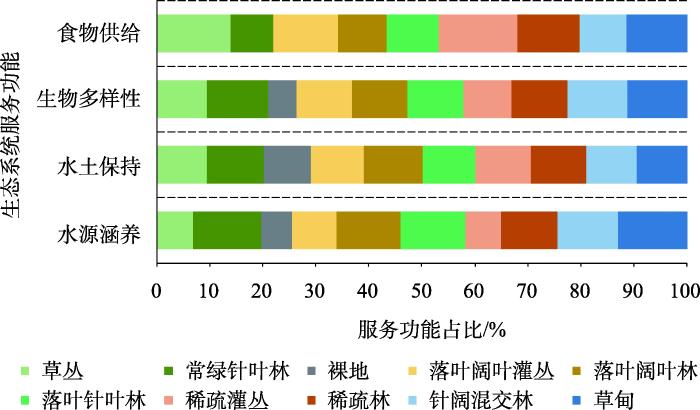
图5
汾河上游不同生态群落的生态功能统计
Fig. 5
Ecological functions statistics of ecological communities in the upper Fenhe River
2.2.3 生态修复分区划定策略
对生态功能分区单元内能够提供最多该生态功能的生态群落采取优先保护措施为主,对其他区域采取调控修复的手段。另外,由于农业开发区、人类活动集聚的城镇建设区等区域在生态修复中要更多地考虑人类生存发展的需要,进行生态修复的独立分区,如重点城镇、行政村等划分为城镇优化建设区,河流水域等划分为河湖水生态保护修复区,矿产资源开发区域等划分为矿山生态环境综合治理区,耕地开发区域划分为农用地综合整治区。在水源涵养生态功能区中,将常绿针叶林、草甸、落叶针叶林、落叶阔叶林、针阔混交林划分为水源涵养优先保护区,将稀疏林、落叶阔叶灌丛、草丛、稀疏灌丛和裸地划分为水源涵养调控修复区。在水土保持生态功能区中,将草甸、常绿针叶林、落叶阔叶林、针阔混交林、落叶针叶林划分为水土保持优先保护区,将落叶阔叶灌丛、稀疏林、草丛、稀疏灌丛和裸地划分为水土保持调控修复区。在生物多样性生态功能区中,将常绿针叶林、针阔混交林、草甸、落叶针叶林、落叶阔叶林划分为生物多样性优先保护区,将稀疏林、落叶阔叶灌丛、草丛、稀疏灌丛、裸地划分为生物多样性调控修复区。在农林牧复合生态功能区中,将稀疏灌丛、草甸、草丛、落叶阔叶灌丛、稀疏林划分为农林牧优先保护区,将落叶针叶林、落叶阔叶林、针阔混交林、常绿针叶林、裸地划分为农林牧调控修复区。
在生态修复分区的划定结果中,农用地综合整治区面积最大,达到1087.49 km2,占研究区总面积27.31%;矿山生态环境综合治理区面积最小,占研究区总面积0.51%。农林牧优先保护区面积大于调控修复区,而水源涵养、水土保持、生物多样性的调控修复区面积大于优先保护区。
2.3 生态修复工程分区与策略
2.3.1 生态修复工程分区
山水林田湖草沙构成一个要素完备的生态系统,在部署生态修复工程项目过程中要避免过去“九龙治水”的困境,综合统筹各类生态要素。黄土高原丘陵沟壑区在长期的生态环境治理中,探索走出了整沟治理的实践路径,一个完整的沟域生态系统涵盖了多个小流域,同时发挥着水源涵养、水土保持、生物多样性、食物供给以及提供人类生产生活空间等多项生态功能。因此,在确定生态功能本底、生态问题区域的基础上,将沟域生态系统作为生态修复工程区的划分单元,统筹多种生态系统服务功能和人类生产生活的和谐共生。通过将小流域单元合并,形成生态修复工程分区单元(图6)。
图6
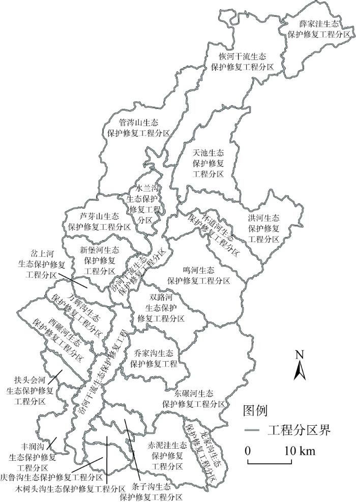
图6
汾河上游生态保护修复工程分区
Fig. 6
Zoning of ecological restoration projects in the upper Fenhe River
研究区总共划分了25个工程区,宁武县10个,静乐县15个。按照属地管理的原则,将汾河干流划分为宁武段和静乐段。东碾河生态保护修复工程区面积最大,包含了东碾河从入境到下游的整个河段,面积428.28 km2,占研究区总面积的10.76%。岔上河生态保护修复工程区面积最小,为38.31 km2,占研究区总面积的0.96%。整体看,宁武县的工程分区面积普遍大于静乐县。
2.3.2 生态修复策略
在生态修复工程分区中,按照生态修复分区安排不同的项目类型,有机地结合修山、治水、造林、整地、生物多样性丰富等各类工程,综合采取各类技术手段。
水源涵养保护修复区主要分布在宁武县的东寨镇、涔山乡等乡镇与静乐县的娑婆乡、康家会镇等乡镇。以加强保护和管理为主,尤其是管涔山、芦芽山等是桑干河、北川河等的发源地,应对这类区域严格限制人类活动,如过度放牧、无序采矿、毁林开荒、开垦草地等。继续加强生态恢复和生态建设,治理土壤侵蚀,恢复与重建水源涵养区森林、灌丛、草地、湿地等生态系统,提高生态系统的水源涵养功能和地表径流滞蓄能力,保持区域生态系统的稳定性。
水土保持保护修复区主要分布在宁武县的东马坊乡、化北屯乡等乡镇与静乐县的神峪沟乡和鹅城镇等乡镇。该区域应严禁在陡坡开垦种植,加快实施25°以上坡耕地生态退耕工程,提高植被覆盖率,控制水域流失和地质灾害。在生态保护修复工程项目安排上,主要是植树造林项目和治沟治坡项目,项目建设内容主要包括封禁、水平梯田建设、淤地坝谷坊、荒山绿化、沟道蓄水工程等。
生物多样性保护修复区主要分布在宁武县的西马坊乡、余庄乡、石家庄镇等乡镇。应对动物栖息地加强保护,修建生态廊道和生物岛,确保廊道与廊道之间、廊道与生物岛之间的连通性的畅通,构建基于生物多样性保护的安全格局,营造良好的生物栖息地环境。主要包括对研究区荷叶坪和马伦草原天然亚高山草甸的草地补播及生物灾害防治,对芦芽山国家级自然保护区和天池高山湖泊群的水源补给、拉网封禁、生境恢复等。
农林牧保护修复区主要分布在宁武县的余庄乡、化北屯乡和凤凰镇等乡镇与静乐县的赤泥洼乡、神峪沟乡和王村乡等乡镇。针对研究区农用地细碎化、利用效率低与无序等问题,开展沟坡丘壑农用地整治,结合水土保持工程项目开展耕地坡改梯,对高标准基本农田提质改造。开展全域农地综合整治,项目建设内容主要包括了平整土地、机修梯田、建设田间道路、营造农田防护林、河滩土层浅薄地土层加厚等。
河湖水保护修复区主要分布在宁武县的东化北屯乡、东马坊乡和石家庄镇等乡镇与静乐县的娑婆乡、康家会镇和段家寨乡等乡镇。由于缺乏保护,汾河源头水质受到不同程度的污染,污染源主要有农村生活污染源、农药与化肥污染、分散禽畜养殖和城镇地表径流。该区域主要任务是实施入河排污口整治工程,新建及提标改造污水处理厂,建造垃圾处理处理站,建设生态沟渠、跌水复氧、人工湿地等。并且开展地下水水质保护工程,降低地下水污染风险。
城镇村优化建设区主要是分别部署城镇基础设施建设项目和乡村生态环境治理项目,项目建设内容主要包括了县城污水处理厂的扩容提标、垃圾填埋厂的建设、雨污管网的分流改造、整村搬迁复垦、河流沿线村庄污水处理等。而对矿山治理区主要是分别部署地表塌陷及边坡防护治理项目、矿区生态环境修复项目、自然灾害防治项目,项目建设内容主要包括了对煤矸石废渣堆、塌陷区、不稳定边坡、火区等的集中治理,对采空区的土地平整复绿以及对废弃矿区遗留建筑物拆除等。
3 结论与讨论
本文以山西汾河上游为例,首先,采用数字高程模型提取地形特征的方法,确定了89个小流域作为生态修复过程的基本单元,其中,32号小流域单元面积最小,仅为9.93 km2,最大的小流域单元84号,总面积达到78 km2,包含了7个行政村。然后,利用Invest模型、通用土壤流失方程(RUSLE)等方法对水源涵养、水土保持、生物多样性、食物供给等主要生态系统服务功能进行评价,综合识别区域主导生态功能,划分了5个生态功能区,其中水源涵养区面积最大,为1442.41 km2,占研究区总面积的36.23%。进而以13种生态群落为基础,通过对不同生态群落的生态功能分析,划分了12种生态修复分区,其中农林牧优先保护区面积大于调控修复区,而水源涵养、水土保持、生物多样性的调控修复区面积大于优先保护区。最后,将沟域生态系统作为生态修复工程区的划分单元,形成了25个生态修复工程分区,其中东碾河生态保护修复工程区面积最大,为428.28 km2,占研究区总面积的10.76%。在工程分区内有机结合修山、治水、造林、整地、生物多样性丰富等各种手段提出生态修复策略。
本文构建的生态修复分区包含了三级分区体系,其中生态功能分区以小流域为单元,通过识别不同小流域的主导生态功能确定未来生态修复的目标。生态修复分区以生态功能分区内生态群落为单元,通过不同生态群落的生态功能分析识别流域内最适宜的生态系统作为区域生态修复的参照系。生态修复工程分区以小流域合并而来的沟域生态系统为单元,以便在后期工程项目实施中统筹考虑河流上下游、山顶山坡山谷,真正实现生态在山上、生产在谷底、生活在沟口的可持续发展模式。需要说明的是,由于数据和方法的不足,本文对研究区所面临的地下水超采、污染等引发的复合型生态问题有所忽视,未来有待进一步纳入评价体系中。同时,在小流域划分过程中,参数、阈值的设定较为主观,可能会对最终的划分结果有一定影响,但通过实地调研,本文的小流域单元的划分与当地林业部门的长期实践认知相一致。
参考文献
Towards the progress of ecological restoration and economic development in China's Loess Plateau and strategy for more sustainable development
Has the Three Norths Forest Shelterbelt Program solved the desertification and dust storm problems in arid and semiarid China?
DOI:10.1016/j.jaridenv.2009.08.001 URL [本文引用: 1]
西藏生态安全屏障保护与建设工程的宏观生态效应
DOI:10.11849/zrzyxb.20170116
[本文引用: 1]

西藏高原是我国重要的生态屏障、江河源区与生物物种基因库,为了保障其生态功能的持续有效发挥,2008年开始实施西藏高原生态安全屏障保护与建设工程。论文基于工程规划目标,通过对比监测2000—2008年与2008—2015年西藏高原生态系统及其关键服务的时空变化,科学地评估西藏高原生态工程的生态效应。结果表明:工程实施前、后8 a相比,1)西藏高原生态系统格局稳定少动,生态系统宏观状况趋向良性发展。森林面积持续增加,荒漠面积显著减少,水体与湿地面积从减少转变为增加。2)草地退化趋势明显减弱、草地恢复态势显著,退化草地占比下降了19.9%,恢复草地占比增加了33%。植被覆盖度增加趋势明显,平均提高了1.9%,特别是高寒草甸类。草地载畜压力明显减少,牧草供给能力提升,草畜矛盾有所缓解。3)生态系统水源涵养能力增加,碳汇总量略有提高,防风固沙服务能力稳步上升。然而,降雨量增加导致降雨侵蚀力增强,植被覆盖度增加但植被根系土壤层无法短时期内恢复,从而导致土壤保持服务能力有所下降。4)西藏高原的暖湿化气候有利于减缓荒漠化进程并促进生态系统恢复,而生态安全屏障保护与建设工程的实施对西藏高原生态系统服务能力的提升特别是工程区局部生态恢复具有一定的正面作用。
The ecological effects of ecological security barrier protection and construction project in Tibet Plateau
DOI:10.11849/zrzyxb.20170116
[本文引用: 1]
Tibet Plateau is an important ecological barrier of China. It is also the source region of many rivers and the gene bank of biological species. In order to protect the ecological function of Tibet Plateau, Ecological Security Barrier Protection and Construction Project was carried out in Tibet Plateau since 2008. Based on the objective of the project, this paper assessed the ecological effects of the Ecological Security Barrier Protection and Construction Project scientifically by comparing and monitoring the temporal and spatial changes of ecosystem and its key services between 2000-2008 and 2008-2015 in Tibet Plateau. Comparing the ecosystem in eight years before and eight years after the project, it was concluded that: 1) The ecosystem structure of the Tibet Plateau was stable and less dynamic, and the macro patterns of the ecosystem tended better. The area of forest continued to increase, the desert was significantly reduced, and the area of water and wetland decreased firstly and then increased. 2) The trend of grassland degradation was weakened, and the grassland was obviously restored. The proportion of degrading grassland decreased by 19.9% and the proportion of restored grassland increased by 33%. The vegetation coverage increased 1.9% in Tibet Plateau, especially the alpine meadow. The significantly reduced loading pressure of grassland and the enhanced forage supply capacity both alleviated the contradiction between grassland and livestock. 3) The capacity of ecosystem water conservation increased, the total amount of carbon sinks increased slightly, and the capacity of ecosystem sand fixation increased steadily. However, the increasing rainfall enhanced the erosion, so soil layer could not recover in a short period in spite of the increase of vegetation coverage. Thus, the capacity of soil conservation service declined. 4) The warm and humid climate in the Tibet Plateau is conducive to slow down the process of desertification and promote the ecosystem restoration, and the implementation of the Ecological Security Barrier Protection and Construction Project has positive effects on the improvement of the ecosystem service capacity, especially in the local regions of the project.
国土空间生态修复: 概念思辨与理论认知
Ecological restoration for territorial space: Basic concepts and foundations
过程耦合与空间集成: 国土空间生态修复的景观生态学认知
DOI:10.31497/zrzyxb.20200102
[本文引用: 1]
新时期国土空间生态修复的核心是整体保护与系统治理,强调生态保护修复与社会经济发展耦合关联的系统性、协同性。景观生态学以景观为研究对象,基于整体综合视角聚焦景观结构与功能演变及其与人类社会相互作用机理,重点关注过程耦合与空间集成。面向国土空间生态修复的战略需求,景观生态学“格局与过程耦合—时空尺度—生态系统服务—景观可持续性”的研究路径能够为国土空间生态修复提供重要学科支撑;依据格局—过程互馈机理识别退化、受损的山水林田湖草生命共同体,基于景观多功能性权衡协调社会—生态需求并确定修复目标,应用生态安全格局优化多层级修复网络体系,建立面向景观可持续性的多尺度级联福祉保障。
Processes coupling and spatial integration: Characterizing ecological restoration of territorial space in view of landscape ecology
DOI:10.31497/zrzyxb.20200102
[本文引用: 1]
The core of ecological restoration of territorial space is the holistic protection and systematic governance in the new period. It emphasizes the synergies between ecological conservation and socio-economic development. Landscape ecology focuses on the dynamics of landscape structure and function, and the interactive mechanism between them and human society from a comprehensive perspective, especially paying attention to processes coupling and spatial integration. The approach of "coupling patterns and processes-spatial and temporal scale-ecosystem services-landscape sustainability" in landscape ecology can provide significant disciplinary support for ecological restoration of territorial space. In the practice of ecological restoration of territorial space, pattern-process coupling theory should be employed to identify degraded or damaged life community of mountains, rivers, forests, farmlands, lakes and grasslands. Ecosystem services tradeoffs of multifunctional landscape for balancing social, economic and ecological demands are used to determine ecological restoration targets. For systematic restoration, the ecological security pattern is an effective way to optimize a multi-level restoration network, and the multi-scale cascade framework for human well-being safeguard can be built based on landscape sustainability.
山水林田湖草生态保护修复思路与实践
Design of implementation path of ecological engineering for ecological protection and restoration of multi ecological elements
典型喀斯特地区国土空间生态修复分区研究: 以贵州猫跳河流域为例
DOI:10.31497/zrzyxb.20220914
[本文引用: 3]
国土空间生态修复是实现生态系统服务可持续供给的重要保障,明确其空间分区是开展生态修复的前提条件。针对现有生态修复分区方法的层级单一、结果针对性欠佳等问题,以典型喀斯特地区贵州猫跳河流域为研究区,构建“自然立地条件—主导生态功能—生态胁迫问题”生态修复分区框架。选取海拔、坡度、地形起伏度、植被类型等自然立地条件指标分析流域内地域分异规律,进而划定生态修复一级分区;基于水源涵养、土壤保持、生物多样性维护、粮食供给等主要生态系统服务功能评价结果识别区域主导生态功能,据此划定生态修复二级分区;结合石漠化敏感性、水土流失敏感性及生态退化度等关键生态胁迫问题指标构建生态修复分区指数识别生态修复重点区域,进而开展生态修复三级分区划分。最终,将猫跳河流域划分为3个生态修复一级分区、10个生态修复二级分区及30个生态修复三级分区,并提出了相应的生态修复策略。研究可为猫跳河流域生态修复实践提供参考,并为西南喀斯特地区生态修复分区提供理论借鉴。
Ecological restoration zoning of territorial space in typical karst region: A case study of Maotiao River Basin in Guizhou
DOI:10.31497/zrzyxb.20220914
[本文引用: 3]
Ecological restoration of territorial space is essentially important to the sustainability of ecosystem services, and spatial zoning plays a significant role in the procedure of ecological restoration. In order to address the problems of simplified zoning level and poor applicability of zoning results, a zoning framework for ecological restoration, "natural site conditions-dominant ecological functions-ecological stress issues" was proposed in this paper. Then a case study was carried out in Maotiao River Basin, a typical karst region in Guizhou. For the first-level zone of ecological restoration, natural condition indicators were selected, such as altitude, slope, topographic relief and vegetation type, to analyze the regional differentiation. Based on ecosystem service functions including water conservation, soil conservation, food supply, and biodiversity maintenance, the dominant ecological functions were identified and the second-level zone of ecological restoration were completed. For the third-level zone of ecological restoration, key ecological stress indicators such as rocky desertification sensitivity, soil erosion sensitivity, and ecological degradation were integrated. Following that, the territorial space of Maotiao River Basin was divided into 3 first-level ecological restoration zones, 10 second-level zones, and 30 third-level zones, and corresponding ecological restoration strategies are proposed. This study can be a scientific support for the ecological restoration of the Maotiao River Basin, and also a helpful reference for the ecological restoration zoning for the southwest karst area in China.
西北生态脆弱区省域国土空间生态修复分区
Ecological restoration zoning of provincial territorial space in the ecologically fragile areas of Northwest China
开都河流域生态安全格局构建与生态修复分区识别
Construction of ecological security pattern and identification of ecological rehabilitation zones in Kaidu River Basin
基于生态安全格局识别的国土空间生态修复分区: 以徐州市贾汪区为例
DOI:10.31497/zrzyxb.20200117
[本文引用: 2]
基于2000年、2008年、2016年遥感影像、历史矿井信息以及GIS空间分析方法,应用生态安全格局研究范式:综合识别生态源地—经井田边界修正生态阻力面—应用电路理论构建生态廊道—判别生态过程障碍区,将代表生态修复需求、生态过程难易和生态要素特征的生态源地、障碍区和生态阻力面空间叠加,最终划定生态修复分区。研究结果表明:(1)三个年份生态源地面积平均约占贾汪区面积的17.77%,随着城镇化发展和矿井闭坑等因素影响呈现先降后升的趋势;生态阻力面变化规律与之相反,并逐步以城镇化发展为主导影响因子。(2)生态廊道分布明显存在整体空间相似性和各镇内部分异性,呈环形沿河流分布或位于植被覆盖较好的低山丘陵区;障碍区明显存在重叠区域,主要分布在京杭大运河以北的区域,以北部和中部较多。(3)划分了生态保育区、生态提升区、生态修复区、生态控制区四个生态修复分区,面积分别为144.38 km<sup>2</sup>、189.60 km<sup>2</sup>、182.68 km<sup>2</sup>、103.34 km<sup>2</sup>。研究结论能够为贾汪区生态转型发展和生态修复提供空间指引。
Ecological remediation zoning of territory based on the ecological security pattern recognition: Taking Jiawang district of Xuzhou city as an example
DOI:10.31497/zrzyxb.20200117 URL [本文引用: 2]
基于“重要性—脆弱性”分析框架的国土空间生态保护修复分区研究
Zoning of ecological protection and restoration for territorial space: Based on "importance-vulnerability" analysis framework
基于适应性循环模型的重庆市国土空间生态修复分区
DOI:10.11821/dlxb202210011
[本文引用: 1]
明确国土空间生态修复分区是有序实施国土整治与生态修复的前提与基础。重庆市是长江上游生态屏障的最后一道关口,在国家生态安全格局中的战略地位突出。本文以重庆市为例,探讨基于适应性循环模型的国土空间生态修复分区研究框架,构建评价指标体系诊断国土空间系统潜力、连通度和韧性3维属性的时空演变趋势,识别县域单元所处适应性循环阶段,划定国土空间生态修复分区,并明确基于分区的生态修复策略。结果表明:① 2000—2020年重庆市国土空间系统3维属性整体呈现东高西低的空间特征。当前各县域单元大多处于重组阶段、开发阶段和协调开发阶段,少部分处于保护阶段,尚未进入释放阶段。② 重庆市国土空间生态修复分区包含4个大区和9个亚区。总体而言,生态修复区应关注建成区的系统性生态修复工程,加强环境综合改良与治理力度;生态提升区应逐步提高生态保护修复工程的实施标准,优化各类生态要素的协调度,提升综合生态效益;生态控制区应限制国土空间开发强度,降低人类活动干扰的负面影响;生态保育区应优化自然生态系统功能,加强生态保护区管理与生态问题治理。
Ecological restoration zoning of territorial space in Chongqing city based on adaptive cycle model
DOI:10.11821/dlxb202210011
[本文引用: 1]
A clear ecological restoration zoning of territorial space is the prerequisite and foundation for the orderly implementation of land remediation and ecological restoration projects. Chongqing is the last gateway to the ecological barrier of the upper reaches of the Yangtze River, with a prominent strategic position in the ecological security pattern of China. Taking Chongqing as an example, this study explored the framework of ecological restoration zoning based on the adaptive cycle model, constructed an index system to evaluate the spatio-temporal characteristics of the three-dimensional attributes of potential, connectedness and resilience of the city's territorial space system, identified the adaptive cycle phase of each county, and discussed its ecological restoration of territorial space. The results show that: (1) The spatial distribution of three-dimensional attributes in the study area from 2000 to 2020 presents a pattern of high in the east and low in the west. Most of the counties in Chongqing are in the reorganization phase, exploitation phase and coordinated exploitation phase, a few are in the conservation phase, and no county has yet entered the release phase. (2) Ecological restoration zoning of the city includes 4 zones and 9 subzones. In general, the ecological restoration zone focuses on systematic ecological restoration projects in built-up areas and strengthen comprehensive environmental improvement and treatment efforts; the ecological enhancement zone should gradually improve the implementation standards of ecological protection and restoration projects, optimize the coordination of various ecological elements, and enhance comprehensive ecological benefits; the ecological control zone should limit the intensity of territorial space development and reduce the negative impact of human activities on ecosystems; the ecological conservation zone should optimize the functions of natural ecosystems and strengthen the management of ecological reserves and the solution to ecological problems.
基于主导功能的国土空间生态修复分区的原理与方法
Principle and method for ecological restoration zoning of territorial space based on the dominant function
基于主导生态功能与生态退化程度的生态修复分区研究
Zoning for ecological remediation by dominant ecological function and ecological degradation degree
基于主导生态功能的江西省国土空间生态修复分区研究
DOI:10.13745/j.esf.sf.2020.10.7
[本文引用: 1]
以地域分异特征、主导生态功能、典型生态问题为基础依据,探讨江西省国土空间生态修复分区,为江西省编制和实施生态修复规划、实现国土空间管控提供科技支撑。在研究方法上,以“生命共同体理论”“三生协调理论”“适宜性管理”等理论为指导,基于主体功能区划和生态功能区划,综合“三生”空间实际生态问题及综合整治需求,采用多因素综合空间分析法,“自上而下”和“自下而上”相结合,实现国土空间生态修复三级分区。研究结果表明,可将江西省国土空间生态修复区域划为赣北平原湖泊生态修复区、赣中丘陵盆地生态修复区、赣西山地丘陵生态修复区、赣南山地丘陵生态修复区、赣东丘陵山地生态修复区5个大区及24个亚区和42个修复小区。通过江西省国土空间生态修复三级分区,摸清国土空间地域特征,明确生态主导功能,确定生态修复重点区域,承上启下,为实施生态修复工程和国土空间管治提供决策依据,为实现国土空间整体保护、系统修复、综合治理提供科技途径。
Territorial land zoning for ecological restoration in Jiangxi province based on dominant ecological function
DOI:10.13745/j.esf.sf.2020.10.7
[本文引用: 1]
In conderations of the regional differentiation characteristics, dominant ecological functions and typical ecological problems, this article explores the territorial land zoning for ecological restoration in Jiangxi Province to provide scientific and technological supports for the preparation and implementation of ecological restoration plans as well as for the realization of land management and control in Jiangxi Province. Guided by the ideas of life community, harmonious rural development, and suitable management, by delineating the principle and ecological functional spaces, and taking into account both the practical ecological problems associated with rural development and the demands for comprehensive development, we use the multi-factor comprehensive spatial analysis method, combined with the “top-down”, “bottom-up” approach, to achieve the three-level ecological restoration of territorial land. The territorial land zoning divides the plains and lakes in northern Jiangxi and the hills and basins in central, western, southern, and eastern Jiangxi into 5 level-1, 24 level-2, and 70 level-3 ecological restoration zones. Through the three-level zoning, the characteristics of the territorial land are clarified, the leading ecosystem function are specified, and the key areas of ecological restoration are identified. It provides a decision-making basis for the implementation of ecological restoration projects and land governance as well as a scientific and technological approach for the overall protection, systematic restoration, and comprehensive governance of territorial land.
基于生态安全格局的国土空间生态修复分区研究: 以贵州省清镇市为例
Research on zoning of ecological restoration in territorial space based on ecological security pattern: A case study of Qingzhen city in Guizhou province
粤北南岭大宝山矿流域山水林田湖草修复阻力与优先级分析
Resistance and priority analysis of landscape forest fields, lakes, and grass restoration in Dabaoshan mining basin
长三角地区城市化对典型生态系统服务供需的影响
DOI:10.31497/zrzyxb.20220613
[本文引用: 1]
长三角地区快速城市化进程影响了生态系统服务供需的平衡关系,为实现长三角一体化高质量发展需要探究城市化对生态系统服务供需的影响。基于生态模型、Pearson相关性、随机森林、局部空间自相关等方法分析城市化和生态系统服务供需间的影响关系、敏感性与空间交互关系,提出生态管理措施。研究发现:2000—2018年间,长三角地区城市化综合水平上涨133.33%;各典型生态系统服务供需比均为正但均呈下降趋势,平均下降幅度22.39%;城市化对生态系统服务供需比具有显著的负向影响,2000—2018年间,影响强度平均上升82.34%;食物生产对人口城市化敏感性较强,碳储存和生境质量对经济城市化敏感性较强,水源涵养和PM<sub>2.5</sub>去除则对空间城市化敏感性较强;城市化与生态系统服务供需比存在较大的空间错配性。由此建议将长三角地区划分为生态利用区、生态重构区、生态源地区和生态修复区,并结合城市化和生态系统服务供需特征提出生态优化管理措施。
Impact of urbanization on supply and demand of typical ecosystem services in Yangtze River Delta
DOI:10.31497/zrzyxb.20220613 URL [本文引用: 1]
基于生态安全格局理论的国土空间生态修复分区模拟: 以粤港澳大湾区为例
Ecological restoration zoning of territorial space based on the pattern simulation of eco-security scenario: A case study of Guangdong-Hong Kong-Macao Greater Bay Area
国土空间治理视角下苏南地区农用地生态修复分区
Ecological restoration zoning of agricultural land of the Sunan district from the perspective of national land and space governance
深圳河河口及新洲河河口湿地生态修复思路及管理对策
Concepts and management countermeasures for eco-restoration of wetland of Shenzhen River Estuary and Xinzhouhe River Estuary
中国水土保持生态修复分区
The study of regionalization on ecological restoration in China
Assessing ecological restoration as a research topic using bibliometric indicators
DOI:10.1016/j.ecoleng.2018.06.015 URL [本文引用: 1]
Recovery and restoration of damaged ecosystems:Proceedings of the International Symposium on the Recovery of Damaged Ecosystems held at Virginia Polytechnic Institute and State University
生态保护与修复理论和技术国外研究进展
Research progress on the theory and technology of ecological protection and restoration abroad
Ecosystem restoration in Europe: Can analogies to traditional Chinese medicine facilitate the cross-policy harmonization on managing socio-ecological systems?
DOI:10.1016/j.scitotenv.2018.11.192 URL [本文引用: 1]
小流域综合治理研究进展
Advances in integrated small watershed management research
2010年来黄土高原景观生态研究进展
Advances in landscape ecology in the Loess Plateau since 2010 in China
山区小流域生态修复研究
Research on the ecological restoration in mountain watershed
基于GIS的小流域地块单元划分与汇流网络计算
Land-unit based flow network model in small catchment with GIS support
DOI:10.11820/dlkxjz.2002.02.006
[本文引用: 1]
Land unit is the basic unit in soil erosion management and ecological environment construction. To understand the roles of water and sand movement among the land units is significant in spatial management of small basins. The land unit is defined as a piece of land with homogeneous geographic characteristics. Within a land unit, the elevation, slope, aspect, soil type or soil texture, landuse or landcover are same or similar. It is now becoming much important in land planning and land management. This paper described the characters and functions of land unit. Based on geographic information system, the methods for land unit dividing, parameters organization, and attribute extraction were expatiated. To meet with the needs of soil erosion model, land productive model and socio economic model, which are main models developed for soil and water conservation measures, a mathematical model for calculating flow network among land units in small catchment was developed. The data set used in the model was grid format elevation data and land unit data layer. The model result was a relation table which shows flow structure of water and sand movement among land units. The flow network relation table then was connected with the erosion model to give out the flow sequence of erosion process.
基于InVEST模型的陕北黄土高原水源涵养功能时空变化
DOI:10.11821/dlyj201604006
[本文引用: 1]
以陕北黄土高原为研究区,基于InVEST水源涵养功能评价模块,定量评价退耕还林还草工程背景下土地利用/覆被变化对研究区水源涵养的影响,在此基础上开展水源涵养空间分区。结果表明:① 2000-2010年,陕北黄土高原草地、灌丛和林地的面积分别增加了3204 km<sup>2</sup>、285.3 km<sup>2</sup>和122.7 km<sup>2</sup>,城镇面积增加了450.4 km<sup>2</sup>;农田、荒漠、湿地的面积分别面积减少了3984.5 km<sup>2</sup>、72.7 km<sup>2</sup>和5.2 km<sup>2</sup>。② 2000-2010年,陕北黄土高原水源涵养量整体以减少为主,中部减少最为显著,减少量在25 m<sup>3</sup>/hm<sup>2</sup>~40 m<sup>3</sup>/hm<sup>2</sup>,局部区域在40 m<sup>3</sup>/hm<sup>2</sup>以上;其他大部分区域均有0~25 m<sup>3</sup>/hm<sup>2</sup>不等的减少。③ 陕北黄土高原水源涵养功能高度重要区和极重要区的总面积为32255.1 km<sup>2</sup>,所占比例为40.5%。④ 通过陕北黄土高原水源涵养功能评价和重要性分区为生态系统的科学管理提供参考。
Spatial and temporal changes of water conservation of Loess Plateau in Northern Shaanxi province by InVEST model
DOI:10.11821/dlyj201604006
[本文引用: 1]
The research on the assessment of ecosystem services is the hot spot and focus in global researches of ecology, geography, and exerted a profound influence on significantly regional ecosystem management, sustainable development and human welfare. We chose the InVEST model, a tradeoff model of regional development and ecosystem management, which provides a quantitative, scientific, dynamic assessment methods for regional water retention. Under the background of the project of Returning Farmland to Forestland, the influence of the land cover changes on the water retention was calculated quantitatively. The main conclusions are as follows: (1) The area of grass, scrub, woodland and towns increased by 3204 km2, 285.3 km2, 122.7 km2 and 450.4 km2, respectively in the Loess Plateau of northern Shaanxi from 2000 to 2010. By contrast, farmland, deserts and wetlands were reduced by 3984.5 km2, 72.7 km2 and 5.2 km2, respectively. (2) Water retention of the research area displayed a decreasing tendency in the 10 years, which has a remarkable reduction of 25 m3/hm2-40 m3/hm2 in the central part of the study area invloving the southwest of Wuding River basin, the upper reaches of Yanhe River and Qingjian River. Part of the central region has a more significant reduction exceeding 40 m3/hm2. And the reduction of other basins in this area was below 25 m3/hm2. (3) On the basis of these studies, the importance level of water conservation capacity in 2010 of the study area has been classified, and the total area of the water retention in highly important area and vital important area reached 32255.1 km2 with a proportion of 40.5%. (4) The assessment of water conservation function and the five partitions of importance level not only provides a reference for the effective management of ecosystems and is of great help to developing planning decisions in a scientific and rational perspective.
基于GIS重庆土壤侵蚀及土壤保持分析
GIS-based spatial analysis of soil erosion and soil conservation in Chongqing, China
基于遥感和InVEST模型的白龙江流域景观生物多样性时空格局研究
DOI:10.13249/j.cnki.sgs.2018.06.018
[本文引用: 1]
以甘肃白龙江流域为例,结合遥感、GIS技术和InVEST模型,从景观地理学角度选取区域生境质量、植物净初级生产力和景观状态指数为评价指标,构建区域景观尺度上生物多样性空间格局综合评估方法,并在栅格像元尺度上开展白龙江流域景观生物多样性时空变化特征分析。结果表明:白龙江流域景观生物多样性空间格局差异显著,其生物多样性高值区主要集中在自然保护区和林业管护区,低值区主要分布在舟曲-武都-文县的白龙江两岸及其以北区域、宕昌县岷江沿岸、高寒稀疏植被区和高山积雪-裸岩区。1990~2010年,流域景观生物多样性较为丰富,整体呈现不断增长的趋势,个别局部区域减弱,其增长区主要体现在生态工程实施区和林业管护区,减少区多分布在人类活动频繁的城乡农耕区和灾害多发区。
Spatiotemporal change of landscape biodiversity based on invest model and remote sensing technology in the Bailong River Watershed
DOI:10.13249/j.cnki.sgs.2018.06.018
[本文引用: 1]
Biodiversity is the material foundation and the environment guarantee that people are taken for their survival and development, and has four levels: molecular, species, ecosystem and landscape. The identification and understanding of the spatiotemporal variation of biodiversity in the landscape level are not just an important part of regional biodiversity monitoring and assessment, but also the first step in the formulation and implementation of the protection scheme. The Bailong River Watershed of the Gansu Province (BRWGP), one of the most abundant biodiversity regions in China, locating in the transitional ecotone along the Tibetan Plateau, Loess Plateau, and Qinba Mountains. The BRWGP served as a case to analyze the spatiotemporal heterogeneity of biodiversity. Based on the data integration analysis platforms of RS, GIS technology and InVEST 2.5.6, a comprehensive index system of biodiversity spatial patterns constructed with the incorporation of habitat quality, vegetation net primary productivity, and landscape state index by considering the difference of three assessment indicators intensity and influence degree. Meanwhile, AHP was used to determine the weights of index and GIS spatial technology apply to analyze the spatial distribution and differentiation of biodiversity under the landscape geography perspective. Our goal went to revise the biodiversity evaluation module of the InVEST model and demonstrate biodiversity spatial patterns on a grid cell. The results indicated that biodiversity was high and had obvious spatial pattern variations in the BRWGP. Areas with higher biodiversity mainly distribute in the national nature reserve and forest, while the relatively poor biodiversity areas distribute in the valleys of the BRWGP between Zhouqu-Wudu-Wenxian, the valley of Minjiang in Tanchang County, alpine mountain snow regions, and bare rock zones. Moderate biodiversity areas appeared in agroforestry ecosystem, shrub and grassland, which a vegetation cover, species richness and habitat quality were general. In 1990-2010, biodiversity was high and increasing, the area proportion of higher biodiversity (critical areas) increased from 16.74% to 26.02%. Meanwhile, the high growth area of biodiversity change was concentrated in the ecological engineering zone and forest districts (Such as these forest districts of Duoer, Axia, the Minshan Mountain, Baishuijiang Nature Reserve), while biodiversity reduction area locates in the region of human activities intensively and frequently, such as cultivated area, urban and rural areas.
基于CA-Markov和InVEST模型的城市景观格局与生境质量时空演变及预测
DOI:10.13287/j.1001-9332.201812.013
[本文引用: 1]
由人类活动引起的城市景观格局变化是影响陆地生态系统的重要因素之一,城市景观格局分布对区域生物多样性服务功能的影响极大.为研究城市景观格局和生境质量演化及其变化原因,以武汉市作为典型区,基于武汉市2005、2010和2015年3期景观类型信息,使用马尔柯夫模型分析其景观格局时空变化特征;采用CA-Markov模型模拟预测武汉市2020年自然增长情景下的景观格局发展方向;使用Logistic回归模型分析景观变化的驱动力;结合InVEST模型评价3期景观格局分布下的生境质量分布和变化,以及2020年模拟情景下的生境质量分布特征,探究景观格局变化与人类活动之间的关系.结果表明: 2005—2015年间,研究区景观类型变化以耕地和人工表面为主.耕地面积呈现逐年减少的趋势,主要转变为人工表面.人工表面面积不断增多,主要由水田和旱地转变而来.研究区整体景观生境质量级别下降,大量高生境质量级别的景观向低生境质量级别转化.整体景观生境质量指数减少,生物多样性服务功能降低,生境质量发生退化.2015—2020年间,武汉市景观格局和生境质量继续保持2005—2015年的变化趋势,表现为人工表面增加、景观生境质量指数减少、生物多样性服务功能降低、生境质量退化.研究区景观格局变化的主要驱动因子是国内生产总值变化和地区财政收入变化.人类社会经济活动是影响研究区景观格局变化和生境质量下降的重要驱动力,城镇化扩张和填湖造地是武汉市生态景观变化的主要原因.
Spatial-temporal evolution and prediction of urban landscape pattern and habitat quality based on CA-Markov and InVEST model
DOI:10.13287/j.1001-9332.201812.013
[本文引用: 1]
The change of urban landscape caused by human activities is one of the most important factors affecting terrestrial ecosystem. The distribution of urban landscape pattern has great impacts on the service function of regional biodiversity. To reveal the variation of landscape pattern and habi-tat quality in cities and its driving factors, we extracted landscape type information of Wuhan in 2005, 2010, 2015, and analyzed spatial-temporal evolution of landscape pattern using Markov transition model. The CA-Markov model was used to simulate the landscape pattern in 2020 under the natural growth scenario. The driving factor for landscape variation was analyzed using Logistic regression model. Combined with InVEST model, spatial pattern of habitat quality and its variation in three phases were calculated and evaluated. The simulated habitat quality in 2020 was obtained and its distribution characteristics were analyzed. The relationship between variation of landscape pattern and human activities was explored. The results showed that cultivated land and manufactured surface were the landscape types with highest variations between 2005 and 2015. The area of cultivated land continued to decline, with most of the area being transferred into manufactured surface. The area of manufactured surface continued to increase, most of which was transferred from paddy field and dry land. From 2005 to 2015, the habitat quality declined, with a large number of landscapes with high habitat quality level being changed to low habitat quality level. The overall index of habitat quality decreased and the biodiversity service function declined, indicating the degeneration of habitat quality. In 2015-2020, the evolutionary trend of landscape pattern and habitat quality would keep consistent with the past decade, with an increasing area of artificial surface, decreasing index of habitat quality, weakening biodiversity service function, and degenerating habitat quality. The most important factor accounted for the landscape pattern change in the study area was the changes in Gross Domestic Product (GPD) and regional fiscal revenue. Human socio-economic activities were the key driving force for the spatial variation of landscape and degeneration of habitat quality. Urbanization and land reclamation by filling lakes were the main reasons for landscape pattern variation in Wuhan.
鄂尔多斯市生态系统服务权衡与协同分析
DOI:10.18306/dlkxjz.2017.12.012
[本文引用: 1]
鄂尔多斯市是中国北方农牧交错带的中心,经济快速发展的同时带来生态环境巨大的压力,该区域生态系统服务及其相互关联的变化对半干旱地区的可持续发展具有重要意义。本文基于2000、2010年鄂尔多斯市的食物供给、碳储存、产水量以及土壤保持4种关键生态系统服务供给核算,采用相关分析探究栅格尺度上4种服务之间的权衡与协同关系,并引入玫瑰图对比不同土地利用类型的生态系统服务关联特征差异。研究结果表明:①2000-2010年鄂尔多斯市生态系统服务整体增强,平均食物供给量由99.5 kg·hm<sup>-2</sup>增至224.2 kg·hm<sup>-2</sup>,碳储存量由8.32 t·hm<sup>-2</sup>增至8.41 t·hm<sup>-2</sup>,平均产水量由153.64 mm增至291.90 mm,土壤保持量平均值由47.79 kg·hm<sup>-2</sup>增至59.04 t·hm<sup>-2</sup>;②产水与土壤保持之间存在协同关系(相关系数分别为0.972和0.771),食物供给与土壤保持之间存在协同关系(相关系数分别为0.505、0.736),食物供给和碳储存之间存在权衡关系(相关系数分别为-0.584、-0.512);③多重生态系统服务供给的热点区主要分布在鄂尔多斯市东部;④产水量和土壤保持、碳储存在耕地和林地中呈现此消彼长的变化方式,而在草地中4种生态系统服务同时增加。
Tradeoffs and synergies between ecosystem services in Ordos city
DOI:10.18306/dlkxjz.2017.12.012
[本文引用: 1]
The city of Ordos is in the central part of the ecotone between agriculture and animal husbandry in northern China, and the rapid economic development brings great pressure to the ecological environment. Ecosystem services and their inter-related changes in Ordos have great significance for the sustainable development of ecosystems in this semi-arid area. This study calculated the four key ecosystem services of food supply, carbon storage, water production, and soil conservation in Ordos in 2000 and 2010, and used the relevant analysis to explore the tradeoffs and synergies between the four services at the 30 m × 30 m grid scale and introduced the rose map. The relationship between the ecosystem services of different land-use types was analyzed. The results show that there is a synergistic relationship between water production and soil conservation, a synergistic relationship between food supply and soil conservation, a tradeoff relationship between soil conservation and food supply, and a tradeoff relationship between food supply and carbon storage. The eastern agricultural area of Ordos contains most of the hotspots of multiple ecosystem services. The production of water reduced as soil conservation and carbon storage improved in cultivated land and woodland, while in the grassland the four ecosystem services increased simultaneously.
基于MODIS数据的河南省冬小麦产量遥感估算模型
DOI:10.16258/j.cnki.1674-5906(2012)10-1665-05 [本文引用: 1]
Remote sensing estimation model of Henan province winter wheat yield based on MODIS data
