

自然保护区拥有高品质的自然人文资源,具有重要的科普价值和发展旅游的先天优势,是国民游憩休闲的重要支撑。随着旅游市场需求的不断扩大,也在客观上推动了自然保护区的旅游化利用,当前,中国大部分自然保护区都进行了旅游开发,并取得了较好的经济效益[4]。生态旅游是自然保护区生态产品价值实现的重要方式,旅游经营收入也是自然保护区管理机构的重要经济来源[5],增加了当地社区居民的收入,激发居民和游客环保行动的积极性[6⇓-8],实现保护地“保护”和“利用”的双重价值[9]。但同时,旅游的发展也对自然保护区带来许多不利影响,如对生态系统产生扰动[10]、影响保护区内野生动物[11]、管理不善造成景观破坏和环境污染等[12]。而随着生态文明建设的推进和一系列政策法规的落地,自然保护区内的旅游开发受到了较大程度的限制,生态环境破坏的现象也得到一定遏制[13],旅游发展逐步走向规范化道路。
自然保护区外围区位于自然保护区法定保护界限的外围,其开发不受《条例》的限制,因而也成为基础设施和各类旅游配套设施的主要建设区域和旅游开发的重点[14]。自然保护区外围具有承接自然保护区旅游核心吸引物游客外溢的天然区位优势,是旅游产业集群形成的重要区域[15]。此外,外围区也是自然保护区内社区迁出的主要目的地,是周边城镇和社区发展的主要承载空间[16]。但同时,外围区与自然保护区毗邻,较其他城镇区域而言其生态环境更加敏感和脆弱,发展规模和路径受到自然条件的制约,也逐渐成为社会经济发展与生态保护矛盾突出的关键区域[17],尤其在旅游发展背景下,如何平衡自然保护区外围区的旅游、生态、城镇化之间的关系,是自然保护区整体性保护和外围区可持续发展的重点。
随着自然保护区相关研究的推进,国内外学者对于其外围区的研究也有所涉及。其中,国外学者主要研究外围区社区发展与居民福祉[18,19]、生态旅游发展[20,21]、资源可持续管理[22]、覆被和生物多样性变化[23,24]等领域。而国内学者多就外围区域的土地利用变化[25,26]、生态系统与生物多样性特征[27,28]、社区居民生计[29]、景观格局特征[30]和规划思路方法[15,31]等进行探讨。保护区外围生态环境变化与保护区息息相关,周边社区也在不同程度上受到保护区管理工作的影响。因此,需要从资源—社会—经济协同的角度对保护区外围进行综合分析。但总体而言,对于自然保护区外围区的研究尚未引起足够关注,已有成果大多关注于自然保护区本体,很少将研究重心放在外围区这一特殊区域上,尤其对于自然保护区外围区的功能解析、外围区与保护区的关系、社会经济发展、空间演变与特征机制等方面的研究鲜少涉及。
综上,本文以自然保护区外围区为研究主体,首先分析旅游导向下自然保护区外围区的重要功能,并构建旅游导向下自然保护区外围区研究的思路框架。其次,以自然保护区管理体制改革的先行区长白山国家级自然保护区为例,尝试从旅游服务、生态稳定、生产生活三个功能空间维度上解析长白山自然保护区外围区的演变过程并分析其驱动机制,归纳演化规律和存在问题,以期为旅游导向下自然保护区外围区可持续发展提供参考和借鉴。
1 研究方法与数据来源
1.1 研究区概况
长白山自然保护区是国家划定较早、面积较大的自然保护区,包括长白山天池北、西、东三面长白山原始森林地区,其自然环境和生态系统较完整,是欧亚大陆北半部自然综合体的典型代表。长白山同时是世界著名的旅游目的地,是第一批国家AAAAA级景区。长白山国际度假区为首批国家级旅游度假区。可以说长白山是东北三省为数不多的具有国际知名度的旅游目的地,是吉林省最具国际影响力的旅游区。
2005年6月,为实现对长白山的“统一规划、统一保护、统一开发、统一管理”,中国共产党吉林省委员会、吉林省人民政府决定成立长白山管委会。2006年1月,长白山管委会正式挂牌,作为省政府派出机构、正厅级建制,代表省政府依法对管理区域内的经济和社会行政事务,以及自然资源实行统一领导和管理。在吉政发〔2006〕30号文件中明确表明:“长白山管委会,具有相当于市(州)政府的行政管理职权。省里将长白山管委会按市(州)对待和管理”,长白山管委会下辖池西、池北、池南3个经济管理区, 5个行政村,并成为自然保护地管理体制创新试验区。
长白山管委会的边界范围存在多个方案,目前比较常用的是长白山保护开发管理委员会按照吉林省政府文件委托管理的管理边界,分为规划指导区、规划管理区和自然保护区。规划指导区即为协调区,面积约为13479 km2;规划管理区即为直管区,面积约为3278 km2;自然保护区即为控制区,面积为1964.65 km2。本文研究的长白山自然保护区外围区是直管区内除去自然保护区红线内的整个区域,其面积共计1313 km2(图1)。
图1
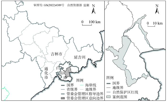
图1
研究区概况
注:本图基于自然资源部标准地图服务系统下载的标准地图制作,地图无修改,下同。
Fig. 1
Overview of the study area
1.2 旅游导向下自然保护区外围区功能与划定
外围区对于自然保护区起到了外围保护和缓冲的作用。在旅游导向下,自然保护区外围区又有别于自然保护区实际控制区,其往往承担了更多样的服务功能,因此需要在功能视角下对自然保护区外围区进行解析和划定(图2)。
图2
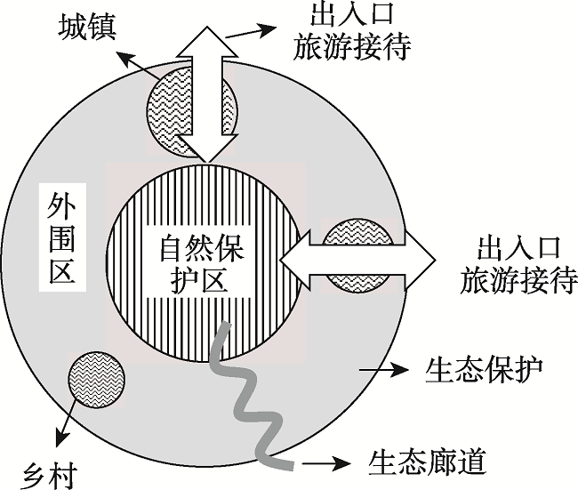
图2
自然保护区外围区主要结构功能
Fig. 2
Main structure and function of the peripheral area of the nature reserve
1.2.1 生态稳定功能
自然保护区外围区是自然保护区内保护的生态系统的延续,对保护区内的生态稳定起到隔离与缓冲的作用,同时也往往是保护区内重要保护生物生态廊道的贯穿区域。外围区生态环境整治也是自然保护区整体保护的重点,而外围区的无序开发将导致保护区内生态系统的“孤岛化”和“碎片化”,不利于达到保护区的整体保护效果[16]。因此,在生态系统整体性保护层面上,自然保护区外围首先需要提供的是生态稳定功能,要连同保护区内形成连贯、稳定的生态空间,保证生态系统的整体性和稳定性。
1.2.2 生产生活功能
自然保护区外围区域与自然保护区紧密相连,而由于其生物多样性和物产丰富的基本特征,往往分布着大大小小的城镇和乡村,是周边社区和城镇发展的重点区,同时也是自然保护区内迁出居民的主要安置区,承担着城乡发展与居民生产生活的基本功能。此外,由于外围区的开发建设不受法律制约,随着社会经济的发展,也成为周边乡村城镇化发展的集中区域,生产生活逐渐成为其重点。
1.2.3 旅游服务功能
外围区是外界进入自然保护区的主要出入口,也是游客进入自然保护区的必经之地。由于自然保护区限制开发的法规约束,相关的旅游服务、旅游接待只能安置在其外围区域,因而外围区也是游客集散区域和旅游服务的集聚区,在旅游导向下,承担着到访自然保护区游客的绝大部分旅游服务功能。
1.2.4 三类功能空间的划定方法
土地利用分类是根据土地利用的差异性划分不同的类别。由于划分目的和依据不同,土地利用分类方法也存在较大差异。现阶段常用的土地利用分类方法主要包括国土资源部组织修订的国家标准《土地利用现状分类》(GB/T 21010—2017)和第三次全国土地调查工作分类方法。上述两种方法均将土地利用类型划分为12个一级类,但其中并无专门涉及“旅游用地”的分类。另一方面,中国目前的法律和政策中也并没有对“旅游用地”做出一个明确的规定,“旅游用地”本身在学术界也是定义未统一的术语[34]。在现有标准中与之相关的仅有“风景名胜设施用地”“文物古迹用地”等部分二级类用地,在多规合一背景下,旅游用地的缺失导致旅游发展与国土空间规划“脱节”[35]。此外,随着“三生空间”统筹推进,针对生产、生活、生态空间与对应的土地利用类型之间的关系愈加明晰。针对自然保护区外围区而言,生产生活空间均依托主要城镇、村落实现,伴生关系明显,而生态空间则相对独立,因此在研究中将生产生活空间合并,生态空间则单独考虑。
表1 基于三类功能的土地利用分类方案
Table 1
| 功能 | 类型 | 对应第三次全国土地调查工作分类与土地利用现状分类 |
|---|---|---|
| 旅游服务功能 | 旅游接待用地 | 无专门划分,此处指酒店、宾馆等游客接待设施用地 |
| 旅游集散用地 | 无专门划分,此处指游客集散服务设施用地 | |
| 旅游景区用地 | 无专门划分,此处指旅游景区、景点用地 | |
| 生产生活功能 | 已建设用地 | 商服用地、工矿仓储用地、住宅用地、公共管理与公共服务用地、部分特殊用地、部分交通运输用地 |
| 待建设用地 | 无专门划分,此处指建设中、拆迁后或尚未利用的可开发用地 | |
| 耕地、园地 | 耕地、园地、设施农用地 | |
| 生态稳定功能 | 水域 | 水域及水利设施用地 |
| 林地 | 林地 | |
| 草地 | 草地 | |
| 其他 | 裸地 | 其他土地(裸土地、裸岩石砾地、沙地、盐碱地等) |
同时需要就上述分类做以下几点说明:(1)因裸地属于未利用土地或难利用土地,故而单独分类,其中待建设用地有别于裸地,属于生产生活用地中的部分建设中、拆迁后或尚未利用的可开发土地,因此属于生产生活功能空间用地;(2)旅游服务中虽然餐饮服务和交通服务是重要的一部分,但由于其存在既服务于游客也服务于居民的特殊性[38],难以完全认定其旅游属性,因此不宜单独分类;(3)民宿、城市公寓等独立旅游住宿多分布在居民住宅小区中,与居住区域难以分开,故不单独统计。
1.3 数据来源与处理
本文选取研究区域2005年、2010年、2015年和2020年的土地利用状况进行分析,其中2005年为长白山管理委员会成立之前,2010年、2015年、2020年为长白山管理委员会成立之后,时间间隔均为5年。相关基础数据分别来源于Landsat遥感数据(30 m栅格)、Google Earth影像数据(0.51 m栅格)、高分二号遥感影像(0.8 m栅格)、POI大数据与全国企业工商注册信息,并结合多源数据辅助解读构建。
其中,将Landsat遥感数据和Google Earth影像数据相结合,经集合校正、配准后通过目视解译对各时期的用地类型进行分类。由于涉及城镇、乡村区域的用地分类识别要求分辨率较高,在相应时期Google Earth影像缺乏的情况下,采用高分二号遥感影像补充。此外,针对旅游服务功能空间仅靠图片信息难以完全识别,因此借助POI大数据和全国企业工商注册信息数据,采用定位回溯的方法,获取相关位置涉及主体的成立时间、营业范围等信息,从而划分旅游接待用地、旅游集散用地和旅游景区用地。
本文中涉及的边界范围、统计数据、酒店信息等相关数据分别来自于长白山管委会官方网站、《长白山保护开发区年鉴》《长白山旅游产业发展年度报告》《长白山管委会工作报告》等年鉴报告、艺龙网(
1.4 研究方法
1.4.1 土地利用程度综合指数
土地利用程度综合指数反映的土地利用集约化程度。用以量化人类活动对于土地系统的影响程度,衡量区域内土地利用情况,其公式如下[39]:
1.4.2 土地利用变化强度指数
土地利用变化强度指数反映区域内单位面积上某一土地利用类型在一段时间内发生的改变,其计算公式如下[41]:
式中:LTI为j类土地利用类型在一定区域内的土地利用变化强度指数;
1.4.3 景观格局指数
2 结果分析
2.1 土地利用类型演变特征
图3
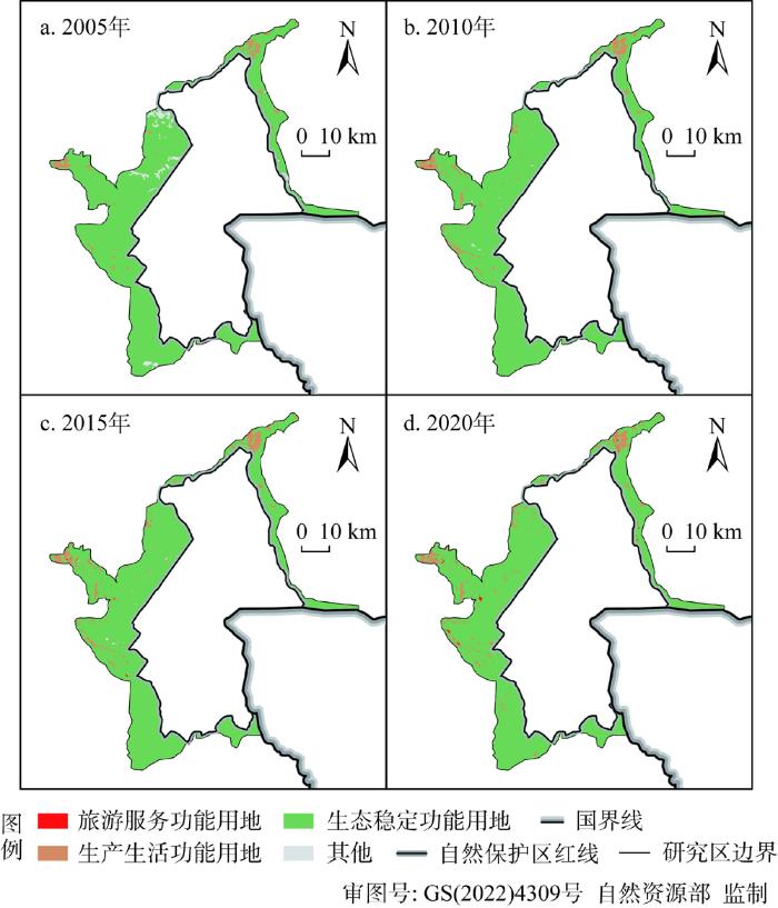
图3
2005年、2010年、2015年、2020年研究区土地利用状态
Fig. 3
Land use status of the study area in 2005, 2010, 2015 and 2020
表2 2005年、2010年、2015年、2020年研究区功能空间和土地利用分类统计
Table 2
| 功能空间 | 用地类型 | 2005年 | 2010年 | 2015年 | 2020年 |
|---|---|---|---|---|---|
| 生态稳定功能空间 | 林地 | 1220.10 | 1233.49 | 1217.71 | 1214.71 |
| 草地 | 20.16 | 18.39 | 18.41 | 19.18 | |
| 水域 | 3.44 | 3.94 | 4.73 | 4.14 | |
| 小计 | 1243.70 | 1255.82 | 1240.85 | 1238.03 | |
| 生产生活功能空间 | 待建设用地 | 1.16 | 1.88 | 3.39 | 3.92 |
| 耕地、园地 | 12.08 | 29.04 | 37.30 | 35.44 | |
| 已建设用地 | 17.74 | 24.48 | 29.11 | 33.23 | |
| 小计 | 30.98 | 55.40 | 69.79 | 72.59 | |
| 旅游服务功能空间 | 旅游接待用地 | 0.04 | 0.22 | 0.77 | 1.15 |
| 旅游集散用地 | 0.00 | 0.00 | 0.04 | 0.10 | |
| 旅游景区用地 | 0.00 | 0.02 | 0.33 | 1.41 | |
| 小计 | 0.04 | 0.24 | 1.13 | 2.67 | |
| 其他 | 裸地 | 38.64 | 1.91 | 1.59 | 0.07 |
从用地转化上来看(图4),2005—2010年间,土地利用变化以裸地的演变为主导,其土地利用变化强度指数达到-0.56%,其次为耕地、园地和林地。土地综合利用程度则由2005年的200.86升至2010年的206.12,表明研究区内土地利用状态受人工干预变强。
图4
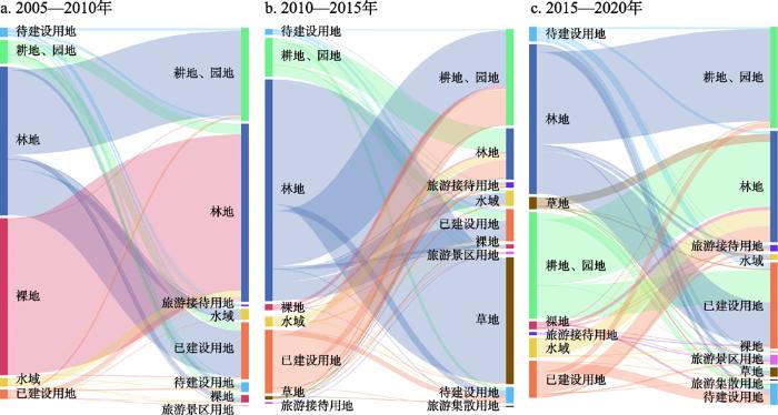
图4
2005—2010年、2010—2015年、2015—2020年各类土地转换示意图
Fig. 4
Schematic diagram of land conversion in 2005-2010, 2010-2015 and 2015-2020
2010—2015年间,土地利用变化以林地的演变为主导,土地利用变化强度指数值达-0.24%,其次为耕地、园地和待建设用地。这期间,土地综合利用程度升至207.84,人类活动对土地利用的影响进一步加剧。
2015—2020年间,研究区土地利用变化以已建设用地变化为主导,其土地利用变化强度指数达0.06%,其次为林地和耕地、园地。这期间,土地综合利用程度升至208.76,但其增速有所下降,表明人为活动和土地开发的格局已基本形成。
2.2 生态稳定功能空间演变
2005—2020年间,研究区内生态稳定功能空间呈现先增加后减少的趋势,变化区域主要集中在池北区和池西区之间红土山子、东土顶子及黄松蒲等地。在三个阶段,生态稳定功能空间的土地利用变化强度指数分别为0.18%、-0.22%和-0.04%,呈现先增加后降低的趋势,一方面是裸地等其他用地转换增加了生态稳定功能空间面积,另一方面生态稳定功能空间逐步转换为生产生活功能空间和旅游服务功能空间,从而引起面积缩减。
从用地类型变化上来看,2005—2010年间,区域生态稳定功能空间有所增加,其中林地面积增加较大,新增林地面积主要来源于裸地转化,说明区内裸地修复治理已见成效。此外,草地面积有所下降、水域面积略有增加。2010—2015年间,区内生态稳定功能空间占比降低,降幅达1.19%,主要体现在林地面积减小,大量林地转换为耕地、园地,部分林地转换为待建设用地和已建设用地,同时受降雨量影响,水域面积有所提升。2015—2020年间,生态稳定功能空间总体面积变化不大,但草地面积出现较大增加,增幅达4.17%,其主要由耕地、园地转换而来,随着农户生计转变,耕地撂荒并逐步演替为草地,加之退耕还林工程推进,大量无序开垦的耕地逐步发生转化。
从景观层面上看(表3),NP增加、SHDI增加、AI下降、C增加,反映出研究区景观格局逐渐多元化,斑块增加、聚集性增强但景观破碎度也随之增强。景观斑块增加区域主要位于池北区二道白河镇、池西区松江河镇、池西经济开发区,其受人类活动影响最大。此外,生态服务功能也与景观分离度、斑块密度和用地破碎度等密切关系,研究区域内用地破碎化将会使斑块内物种减少,生物多样性减少,生物生境和资源也必将随之受到影响。但值得注意的是,2005—2020年间,LPI增加、CONTAGE先增加后减小,而研究区内的优势斑块为林地,说明在生态治理中,针对优势斑块的保护具有一定成效,有利于优势斑块类型形成良好的连接性,从而对生态稳定功能产生一定积极影响。
表3 2005年、2010年、2015年、2020年研究区部分景观格局指数
Table 3
| 年份 | NP | LPI | SHDI | CONTAG | AI | C |
|---|---|---|---|---|---|---|
| 2005年 | 339.0000 | 9.1714 | 0.2555 | 91.0937 | 98.1648 | 0.2581 |
| 2010年 | 575.0000 | 9.2558 | 0.2810 | 92.1203 | 97.9861 | 0.4378 |
| 2015年 | 676.0000 | 9.3154 | 0.2829 | 92.0426 | 97.7509 | 0.5147 |
| 2020年 | 1015.0000 | 10.0281 | 0.3266 | 91.4294 | 97.0362 | 0.7728 |
2.3 生产生活功能空间演变
2005—2020年间,研究区生产生活功能空间不断扩张,其主要变化区域集中在池北区(二道白河镇)、池西区(松江河镇)及池南区(漫江镇)。在三个阶段,生产生活功能空间的土地利用变化强度指数分别为0.37%、0.22%和0.04%,增幅逐渐降低,主要由生态稳定空间转换而来。
从各类用地类型上看,2005—2015年间,耕地、园地出现较大幅度增加,其中2005—2010年间增长率为140.46%,2010—2015年间增长率为28.43%,主要转移类型为林地转换为耕地、园地,而2015—2020年间耕地、园地面积出现小幅下降,降幅4.99%,主要出现在耕地转化为已建设用地上。2005—2020年间,待建设用地和已建设用地均出现持续大幅度增长。其中,待建设用地在2005—2010年间和2010—2015年间分别增长了61.90%和80.33%,在2015—2020年间增长率为15.82%,而已建设用地在2005—2010年、2010—2015年和2015—2020年间增长率分别为37.96%、18.91%和14.17%。待建设用地主要由耕地、林地和部分已建设用地转化而来,而已建设用地主要由林地、草地和待建设用地转换而来。
以上变化反映出生态稳定功能空间逐渐转化为生产生活功能空间,呈现出保护区外围区城镇化逐步扩张的整体趋势。土地利用方式的转换在社会经济层面则表现为区域发展模式的转型。在长白山管委会的统一管辖之下,改变原有多头治理的管理模式,落实统一规划,一方面加快布局大量基础设施,如长白山机场、火车站等,另一方面实行了大规模的棚户区改造,大量地产项目快速发展。此外,土地主导功能的转化映射了产业结构的变化,长白山管理区逐渐形成了旅游、文化、特色生态资源、矿泉水“四大产业”,带动旅游商贸、会议会展、现代物流、总部经济等战略性新兴产业发展,三大新兴产业园区逐步落成,地区生产总值、全社会固定资产投资、地区财政收入出现明显增加(图5)。虽然城镇建设规模扩张,但通过对比发现,2005—2020年间,整个长白山管委会管辖区域范围内城镇人口数量并没有显著增加,大量地产项目面向的主要是外地人口,生产生活服务功能空间的用地利用效率仍需要提升。
图5
图5
2005—2019年间长白山管委会社会经济发展统计指标
Fig. 5
Statistics of socio-economic development of Changbai Mountain Management Committee from 2005 to 2019
2.4 旅游服务功能空间演变
2005—2020年间,研究区旅游服务功能空间不断增加,其主要变化区域集中在池北区二道白河镇、池西区松江河镇,旅游服务功能空间增多主要体现在生产生活空间转换。在三个阶段,旅游服务功能空间的土地利用变化强度指数分别为0.003%、0.014%和0.023%,增幅逐渐增加,体现了研究区旅游产业的快速发展。
2005—2020年间,研究区的旅游服务功能空间平均增幅为349.19%,从土地利用类型变化情况来看,功能空间的扩张主要表现为旅游景区和旅游接待用地增加。其中旅游酒店用地在2005—2010年、2010—2015年、2015—2020年三个时段内增幅分别为485.22%、249.80%、50.16%,而旅游接待和旅游景区用地则是从无到有。从转换类型上看,主要是已建设用地、林地和耕地转为旅游服务用地,其中尤以生产生活用地转为旅游服务用地为主,这体现出生产生活逐渐向旅游服务转化,也反映出城镇产业结构的逐步调整。
旅游服务功能空间的增加反映出案例区以旅游接待用地增加为主,旅游接待和旅游景区用地协同增长的基本特征,这与长白山管委会大力推动星级酒店、温泉酒店、度假村建设息息相关。基于艺龙网酒店信息库,对研究区内的酒店信息提取,获取酒店名称、所在地址、房间数、床位数和开业时间,进一步核对酒店所在区域,形成长白山自然保护区外围区酒店信息清单,统计后可以发现(表4),2005—2020年间,酒店数量和客房数量大幅增加,其酒店数量和客房数量的变化与旅游服务用地变化具有相似规律。
表4 2005年、2010年、2015年、2020年研究区酒店数量统计
Table 4
| 年份 | 池北区 | 池西区 | 池南区 | 总计 | |||||||
|---|---|---|---|---|---|---|---|---|---|---|---|
| 酒店/个 | 客房/间 | 酒店/个 | 客房/间 | 酒店/个 | 客房/间 | 酒店/个 | 客房/间 | ||||
| 2005 | 1 | 150 | 0 | 0 | 0 | 0 | 1 | 150 | |||
| 2010 | 9 | 491 | 6 | 113 | 0 | 0 | 15 | 604 | |||
| 2015 | 55 | 2996 | 52 | 4471 | 1 | 60 | 108 | 7527 | |||
| 2020 | 337 | 8683 | 217 | 8264 | 10 | 213 | 564 | 17160 | |||
此外,为进一步推动旅游业发展,除自然保护区外,管委会加快其他景点的打造和全域旅游的发展,从而延长游客游玩时间,进而推动2015—2020年间旅游景区用地的快速增长。2005年以来,除长白山景区被评为国家AAAAA级旅游景区外,研究区域内还增加了4家国家AAAA级旅游景区(二道白河镇、讷殷古城、露水河森林公园、峡谷浮石林),池北区被评为首批国家全域旅游示范区。通过旅游统计可以发现(图6),2006—2019年间,长白山旅游快速发展,而长白山管委会全区旅游人数与长白山景区的旅游人数之间的差值逐渐增大,表明除长白山景区已不再是区内唯一的旅游吸引物,全域旅游服务功能凸显。
图6
图6
2005—2019年间长白山管委会旅游人数统计
Fig. 6
Tourism statistics of Changbai Mountain Management Committee from 2005 to 2019
2.5 功能空间演变的驱动机制分析
在自然保护区外围区土地利用演化过程中,一方面“生态稳定—生产生活—旅游服务”三类功能空间相互转化、相互影响,另一方面区域经济发展模式改变、产业调整和管理政策通过对土地利用方式的影响而作用于空间功能,并牵扯到政府、居民、企业等多利益主体之间的博弈和共赢(图7)。
图7
图7
三大功能空间转化机制分析
Fig. 7
Analysis of three functional spaces transformation mechanism
在自然因素方面,受地形、水土等自然因素和传统农村农业生产方式的影响,自然保护区外围区内的耕地、园地整体呈现分散、无序式扩张,影响景观格局,导致景观破碎化。但同时受到气温、降水等自然环境条件影响,植被年际生长状况有所差异也带来了生态稳定功能空间的变化,推动裸地向生态稳定功能空间演替。
在政策落实方面,主要受到国家和区域政策影响,随着生态文明建设和国家公园体制试点等相关政策的推进,长白山地区的森林生态修复受到广泛关注。生态建设和自然保护是保护区的首要任务,大量资源倾注到保护区及外围“山水林田湖”修复等重点工程上,以提升生态建设成效。此外,随着国家退耕还林等政策要求,耕地无序开垦状态得到抑制,推动生产生活空间向生态稳定空间转换。
在城镇发展方面,在政府主导下随着城镇和乡村风貌整治、旧城(村)更新和棚户区改造等一系列工程实施,使城乡用地集约化增强。而城镇化也使农户生计转型,推动耕地撂荒向草地、林地演替。同时,保护区周边良好的生态环境和旅游发展态势进一步吸引开发商投资建设大量地产项目,推动城镇化发展和旧城改造的进程。但随着城镇不断扩张,城镇周边原有的生态稳定空间逐步被侵占,景观格局破碎化现象突出。
在产业发展方面,受保护区保护要求限制,其外围城镇和乡村的产业结构发生改变,一方面体现在原有第二产业转型或外迁,大量无序开垦的耕地得到整治,以旅游为主导的经济发展模式逐步形成,推动了生产生活功能空间向旅游服务功能空间转变,而这一转化也带来了经济发展、居民收入增加和就业增加,更多居民参与旅游发展。同时旅游发展也要求生产生活空间和生态稳定空间的优化,从而构建良好的旅游基础环境。但保护区内旅游承载力有限,为更好地吸引并留住游客,外围区成为旅游设施和接待服务提升的关键区域,政府和开发商建设了大量高品质的旅游度假酒店、游客集散中心。此外,部分自然景观良好或具有人文特色的区域转而开发成为旅游景区形成新的旅游吸引物。例如在长白山自然保护区外围区中,除长白山景区外,魔界风景区、美人松苑、美人松雕塑公园、长白山国际滑雪场等近年来新开发的景区逐渐成为长白山管委会辖区内的“热门”经典,游客来长白山不仅只是看自然保护区内的风景,周边度假和慢游休闲成为重要的旅游方式,池北、池西、池南三区联动形成长白山全域旅游发展的新格局。
以上各因素的作用均离不开长白山管委会的统一管理。长白山管委会作为省政府的派出机构,为正厅级建制,代表省政府依法对管理区域内的经济和社会行政事务以及森林、草原、水流、山岭、土地、矿藏等自然资源实行统一领导与管理。不同于一般的管委会管理模式,长白山管委会具有地方管辖治理的实际功能,而不是与地方政府平级并行的另一套班子。因此在统一规划、统一管理的理念指导下,针对居民、企业、开发商等相关利益主体的约束力更强,市场、社会力量在政府力量的统一推动下,规划先行、按规执行,通过地方政策和行政管制来影响土地转化方向,从而形成旅游发展、资源保护、城镇建设“一盘棋”,有效推动自然保护区保护和外围区发展,也是外围区不同功能空间演化的主要驱动力量。
通过总结可以发现,以旅游作为产业发展主导,推动生产生活功能空间和生态稳定功能空间向旅游服务功能空间转化是自然保护区外围区功能空间演化的主要方向。而就本文而言,研究区域旅游开发尚处在快速扩张阶段,还未探测出旅游服务功能空间向生产生活功能空间和生态稳定功能空间转化的实例。但随着政策转向、用地约束、产业发展趋于饱和等因素影响,尤其在管委会统筹管理下,随着旅游发展逐渐逼近承载力上限,未来也将会出现旅游服务功能空间向生产生活功能空间和生态稳定功能空间转化的现象,尚需持续跟踪监测。
3 结论
基于多源数据分析,在土地利用格局研究基础上,本文构建了旅游导向下自然保护区外区功能空间演变分析的研究框架,并以长白山国家级自然保护区外围区为案例地,探讨其空间演变及机制,得出以下结论:
(1)基于土地利用功能解析,在旅游导向下,将自然保护区外围区划分为生态稳定功能空间、生产生活功能空间、旅游服务功能空间共三类功能空间,并结合9种土地利用类型的划分,对三大功能空间进行识别。
(2)2005—2020年间,长白山自然保护区外围区功能空间始终以生态稳定为主导,其中,旅游服务功能空间占比最小。但同时,随着城镇化和旅游产业发展,土地利用状态受人工干预逐渐变强,生态稳定功能空间逐渐向生产生活功能空间和旅游服务功能空间转化。功能空间变化主要集中在人为活动较为密集的城镇周边。
(3)15年间,案例区生态稳定功能空间呈现先增加后减少的趋势,大量裸地转换为林地、草地,而部分林地转换为耕地、园地和建设用地。整体上看,研究区景观格局逐渐多元化、景观破碎度增加,但在优势斑块保护方面具有一定成效。生产生活功能空间不断扩张,但增幅有所降低,大量生态用地转化为生产生活用地,保护区外围区城镇建设加速,然而同期城镇人口却没有显著增加。此外,旅游服务功能空间有效增加,旅游产业快速发展,其中以生产生活用地转为旅游服务用地为主,酒店、景区供给显著增加,带动城市产业结构调整,全域旅游发展之势形成。
(4)受自然环境、政策落实、社会经济发展等因素影响,旅游导向下自然保护区外围区“生态稳定功能—生产生活功能—旅游服务功能”三大功能空间相互转化。主要演化方向包括生态稳定功能空间—生产生活功能空间、生产生活功能空间—生态稳定功能空间、生产生活功能空间—旅游服务功能空间、生态稳定功能空间—旅游服务功能空间4种类型,三类空间在管委会统一管理下有序演进。其中,生态建设的政策落实是向生态稳定功能空间转化的主要动力,城镇发展是向生产生活功能空间转化的主要动力,而以旅游为主的产业导向是旅游服务功能空间转化的主要驱动力。
在当前中国自然保护地体系建设逐步完善的背景下,外围区的保护与可持续发展也需要更多关注。生态稳定、生产生活和旅游服务是旅游导向下自然保护区外围区空间所承担的主要功能,三类空间的演变过程反映了相关功能的转化和外围区发展的基本路径。作为自然保护地管理体制创新的试点区,长白山管委会在保护区及外围区规划、协调、开发方面起到主导作用。通过本文的实证分析,可以在动态上掌握自然保护区外围区的演变过程和规律,并进一步明晰功能空间转化的动力机制,从而为自然保护地周边区域的可持续发展提供新的研究思路和发展借鉴。另一方面,本文通过对多源数据的分析,在不同维度上刻画案例地的演变过程和效果,可为相关研究提供新思维。但同时,本文仅以土地利用为基础对三大功能空间进行了划分,对于社会、经济等多层次的空间演化解析尚未充分涉及。考虑到旅游发展与城镇生产生活不能完全剥离,此类功能空间的划分方法也需要进一步的论证,但作为一种功能空间划分的尝试,一定程度上也反映出了区域发展和空间演替的方向和趋势。此外,本文针对空间演变带来的生态服务效益、社会经济效益、旅游产业效益的描述和评估尚为单薄,三大功能空间的耦合和相互作用关系及机理尚不明晰。在高质量发展要求下,自然保护区外围区需要构建明确的目标体系,在三大功能协调下形成可持续发展的基本路径。因此,以本文作为基础,相关研究仍有待进一步提升,并需要更多的理论探索和实证经验提炼。
参考文献
中国自然保护区可持续管理政策研究
A policy study on sustainable management for China's nature reserves
DOI:10.11849/zrzyxb.2000.03.002
[本文引用: 1]

Rapid development of protected areas has raised a very important question on how to manage them in an effective and sustainable manner.This is a common issue confronting policies of various governments around the world.The biosphere reserve concept provides a trajectory to the solution of this issue.Chinas nature reserves were established under conditions of huge population pressure and resources demand,and guidence by policies of rescue and protection.With this background,the problems that the responsibility in administration system is not well clarified and the nature reserve management conflicts with economic development have occurred and hindered the further development of the nature reserves.To solve the problem, a comprehensive policy reform is needed.
自然保护区生态补偿研究与实践进展
Research and practice progress of ecological compensation in nature reserves
我国自然保护区的旅游研究进展
Research on tourism in nature reserves of China
基于消费端的自然保护地指标交易机制: 生态产品的价值实现
Research on consumer-based quota trading mechanism of protected areas: An innovative approach to achieve value of ecological products
Living on the edge: Benefit-sharing from protected area tourism
DOI:10.1080/09669582.2019.1615496
[本文引用: 1]
Tourism in protected areas not only plays an essential role in terms of contributing to the financial sustainability of protected areas but through effective and efficient benefit-sharing can positively impact numerous stakeholders within and beyond the protected area. This paper provides a brief analysis of the evolution of benefit-sharing from protected area tourism, discussing tangible and intangible benefits and highlighting that revenue-sharing is only one way of sharing benefits from tourism and protected areas. The paper highlights the complexity of benefit-sharing, the importance of identifying all relevant stakeholders, the challenges of ensuring equity and sustainability and the critical importance of good governance. The evolution of benefit-sharing mechanisms over time emphasises a continuing need to evolve and adapt to each unique situation, as much evidence indicates that little has changed for those living on the edge. Although this paper focuses on benefit-sharing from protected area tourism, it is essential to acknowledge that along with these benefits are costs associated with tourism, including possible increased local prices, loss of access to land, human-wildlife conflict, and other related costs. Recommendations for future research are included to encourage an ongoing evolution and improvement in benefit-sharing mechanisms.
自然保护区生态旅游影响评价: 进展与启示
Ecotourism impact assessment of nature reserves: Progress and enlightenment
中国自然保护地旅游产品类型及其特征
Types, typology and features of China's protected area tourism products
Exploring the historical evolution of tourism-environment interaction in protected area: A case study of Mt. Bogda
DOI:10.1007/s11442-022-1941-5
[本文引用: 1]
Protected areas have a double mandate of both “protection” and “use.” Nature- based tourism is considered an effective tool in terms of environmental conservation. Understanding the causes and consequences of a spatiotemporal succession of tourism construction is an important channel to explore the changes of tourism-environment interaction in the protected area. To analyze the spatio-temporal variations in tourism construction lands, we adopted Mt. Bogda as an example. We systematically quantified the interaction between these changes and environmental variables and explored the evolution process of tourism-environment interaction of the mountainous protected area in the northwest arid region. Our results revealed the following: (1) In the Bogda protected area, the proportion of tourism construction lands first appeared to be increasing, then decreasing dramatically, and finally growing slowly. The spatial expansion of tourism construction lands followed the “core-periphery” pattern, respectively showing shapely infilling, reasonable agglomeration, barycenter shift, and outlying growth from 1990 to 2018 as the stages of concentrating on the core. (2) The higher land-use intensity of tourism construction drove the changes of landscape fragmentation, diversity, stability, primitive, and nature degree in the protected area. The coupling coordination between tourism and the environment in the Bogda area decreased at first, and then slowly increased. Meanwhile, tourism did not cause irreversible damage to the natural environment, and the coupling coordination degree between tourism and the environment was still in the state of balanced development. It expressed the states of original balanced, development exceeds environment and barely balanced, and superiorly balanced. The historical evolution of tourism-environment interaction in Bogda reflects the pattern of periodic changes in China’s protected areas to a certain extent.
芦芽山自然保护区旅游开发与植被环境关系: 旅游影响系数及指标分析
Relationship between tourism development and vegetation environment in Luya Mountain Nature Reserve: Tourism influencing index and some indices analysis
Impacts of tourism and hunting on a large herbivore's spatio-temporal behavior in and around a French protected area
DOI:10.1016/j.biocon.2014.05.022 URL [本文引用: 1]
自然保护区生态旅游环境承载力综合评价指标体系初步研究
Integrated indicator system of eco- tourism environmental load capacity in nature reserves
祁连山自然保护区旅游景点整改前后的生态变化
Ecological changes before and after the reform of tourism development zone in Qilian Mountains National Nature Reserve
CLUE-S 模型在长白山自然保护区外围规划中的应用
Application of land use model CLUE-S in the planning of surrounding the Changbai Mountain Biosphere Reserve
自然保护地外围乡村聚落旅游发展研究: 以重庆市城口县兴隆村为例
Study on the development of rural settlement tourism in the periphery of nature reserves: A case study of Xinglong village, Chengkou county, Chongqing
生态文明视角下自然保护区外围地区规划对策探讨: 以长白山国家级自然保护区外围地区为例
Research on the planning of peripheral areas of natural reserves from the perspective of ecological civilization: A case study of the peripheral areas of Changbai Mountain National Nature Reserve
Impact of tourism development on land-cover change in a matriarchal community in the Lugu Lake area
DOI:10.1080/13504500809469765 URL [本文引用: 1]
Constraints of community participation in protected area-based tourism planning: The case of Malawi
DOI:10.1080/14724049.2016.1251444 URL [本文引用: 1]
The Benefits of Nature Reserve Areas in Local Development:An Ppportunity to Develop a Sustainable Strategy in Peripheral Areas
Tourist towns on the edge: Conceptualising vulnerability and resilience in a protected area tourism system
DOI:10.1080/09669582.2013.855222 URL [本文引用: 1]
Evaluation of the sustainable tourism potential of a protected area for landscape planning: A case study of the ancient city of Pompeipolis in Kastamonu
Conflicts, conservation and natural resource use in protected area systems: An analysis of recurrent issues
Long-time interval satellite image analysis on forest-cover changes and disturbances around protected area, zeya state nature reserve, in the Russian far east
Boreal forest areas in the Russian Far East contained very large intact forests. This particular area is considered one of the most productive and diverse forests in the boreal biome of the world, and it is also home to many endangered species. Zeya State Nature Reserve is located at the southern margin of the boreal forest area in the Russian Far East and has rich fauna and flora. However, the forest in the region faced large-scale forest fires and clearcutting for timber recently. The information of disturbances is rarely understood. This study aimed to explore the effects of disturbance and forest dynamics around the reserve. Our study used two-year overlaid Landsat images from Landsat 5 Thematic Mapper (TM) and 8 Operational Land Imager (OLI), to generate forest-cover-change maps of 1988–1999, 1999–2010, and 2010–2016. In this paper, we analyze the direction of forest successional stages, to demonstrate the effectiveness of this protected area in terms of preventing human-based deforestation on the vegetation indices. The vegetation indices included the normalized burn ratio (NBR), the normalized difference vegetation index (NDVI), and the normalized difference water index (NDWI). The study provided information on the pattern of forest-cover change and disturbance area around the reserve. The NDWI was used to differentiate between water and non-water areas. The mean values of NBR and NDVI were calculated and determine the forest successional stages between burn, vegetation recovery, grass, mixed forest, oak forest, and birch and larch forest. The accuracy was assessed by using field measurements, field photos, and high-resolution images as references. Overall, our classification results have high accuracy for all three periods. The most disturbed area occurred during 2010–2016. The reserve was highly protected, with no human-disturbance activity. However, large areas from fire disturbance were found (137 km2) during 1999–2010. The findings also show a large area of disturbance, mostly located outside of the reserve. Mixed disturbance increased to almost 50 km2 during 2010–2016, in the buffer zone and outside of the reserve. We recommend future works to apply our methods to other ecosystems, to compare the forest dynamics and disturbance inside and outside the protected area.
Dragonflies within and outside a protected area: A comparison revealing the role of well-preserved atlantic forests in the preservation of critically endangered, phytotelmatous species
DOI:10.1007/s10841-022-00385-4 [本文引用: 1]
庐山自然保护区及其周边土地利用变化分析
Analysis of land use change in lushan nature reserve and its periphery in Jiangxi province
戴云山自然保护区及其周边土地利用/覆盖研究
Daiyunshan Nature Reserve and its surrounding land use/cover research
湖南高望界国家级自然保护区及其周边蝶类多样性与影响因素
Butterfly diversity and its influencing factors in the Hunan Gaowangjie National Nature Reserve and its surrounding area
DOI:10.17520/biods.2019342 URL [本文引用: 1]
长白山国家自然保护区及其周边地区生态脆弱性评估
DOI:10.13287/j.1001-9332.201905.030
[本文引用: 1]
在全球变化与人类活动的双重冲击下,探究自然保护区及其周边区域的生态脆弱状况对于保证区域的生态安全和人类自身的可持续发展至关重要.以长白山国家自然保护区及其周边30 km缓冲区为研究区域,结合“敏感度-恢复力-压力度”概念模型和空间主成分分析法评估保护区内外2005和2015年的生态脆弱状况并分析其背后的主要驱动因子.结果表明:2005和2015年,保护区内外的生态脆弱性等级均以潜在脆弱、微度脆弱和轻度脆弱为主,该区域的生态脆弱状况总体处于较好水平;2005—2015年间,保护区内外整体的生态脆弱性呈现略微上升趋势,区内、外发生退化的区域面积分别为254和967 km<sup>2</sup>,区内、外对该趋势的贡献占比分别为30.8%和69.2%;区内生态脆弱性在空间格局上的变化主要与净初级生产力(NPP)、植被覆盖度和距离道路最近距离的变化有关,而在区外,主要与NPP、植被覆盖度、国内生产总值(GDP)密度的变化有关.
Ecological vulnerability assessment on Changbai Mountain National Nature Reserve and its surrounding areas, Northeast China
DOI:10.13287/j.1001-9332.201905.030
[本文引用: 1]
Exploring the ecological vulnerability of nature reserve and its surrounding area is essential to the maintenance of regional ecological security and sustainability of human development, especially under the stress of global change and human activities. Based on the integration of "sensitivity-resilience-pressure" conceptual model and spatial principal component analysis (SPCA), we analyzed the ecological vulnerability of Changbai Mountain National Nature Reserve and its surrounding 30 km buffer in 2005 and 2015. The main driving factors were further analyzed. The results showed that the ecological vulnerability of Changbai Mountain Nature Reserve was mainly potential, slight, and light levels in 2005 and 2015, indicating the ecological vulnerability inside and outside the reserve was in a good condition. For the whole region, the ecological vulnerability showed a slight downward trend from 2005 to 2015. The degradation area inside and outside the reserve were 254 and 967 km<sup>2</sup>, respectively, with the contribution rate to the increase of overall vulnerability being 30.8% and 69.2%, respectively. The changes in ecological vulnerability inside the reserve were mainly related to the changes in net primary production (NPP), vegetation coverage, and the nearest distance to the road, whereas it was mainly related to the changes in NPP, vegetation coverage and gross domestic product (GDP) density outside the reserve.
农户生计资本与生计策略关系的实证分析: 以河西走廊沙化土地封禁保护区外围为例
DOI:10.7522/j.issn.1000-694X.2015.00138
[本文引用: 1]
从农户可持续生计框架出发,以河西走廊六县为调研对象,建立了农户生计指标体系并对其进行评估,从而揭示了当地农户生计资本与生计策略之间的影响关系。结果表明:(1)无论是项目组还是对照组,农户的5种生计资本整体比较稀缺,其中自然资本和金融资本极度匮乏,而人力资本、社会资本和物质资本相对较丰富,因此农户生计资本单一且配置极不合理,从而导致农户脆弱性程度高。(2)自然资本、人力资本和物质资本对农户生计策略的影响比较显著,其中自然资本和物质资本丰富的农户往往倾向于选择农业生产,而人力资本丰富的农户往往倾向于选择非农产业。(3)经定量评估对照组农户的农业兼业化程度要比项目组农户高。基于此,政府可以采取诸多措施来改善农户的生计现状,从而提升农户的生计水平,进一步转变当地农业的发展模式,缓解生态压力。
Empirical analysis of relationship between farmers' livelihood capital and livelihood strategies: A case of Hexi Corridor closing area for protection of desertified land perimeter
九寨沟自然保护区景观变化与保护
The changes of landscape and the adaptive management strategies at Jiuzhaigou Nature Reserve in Sichuan, China
世界遗产风景名胜区外围保护地带的规划探索: 以青城山—都江堰风景名胜区总体规划为例
Planning exploration of peripheral protection zone in world heritage seritage scenic and historic area: Taking general plan of Qingchengshan-Dujiangyan Scenic and Historic Area as an example
中国“三生空间”演变特征、生态环境效应及其影响因素
DOI:10.31497/zrzyxb.20210503
[本文引用: 1]
基于1990年、2000年、2010年和2018年土地利用现状遥感监测数据,利用转移矩阵对中国“生产—生活—生态”结构转型的时空演化特征进行研究,引入生态环境质量指数和土地利用转型的生态贡献率分析中国1990—2018年“三生空间”变化的生态环境效应,利用地理加权回归模型(GWR)对中国生态环境效应的主要影响因素及其作用效应的空间分异进行识别。结果表明:(1)研究期内中国生产、生活空间增加,生态空间减少,总体呈现“入不敷出”的态势。(2)中国1990—2018年生态环境质量的高值区以中国的南部和东北部为主,低值区主要分布在胡焕庸线西北部;其他生态空间和农业生产空间对草地和林地生态空间的挤占是导致研究期内生态环境质量恶化的重要原因。(3)坡度、年平均降水量、土地利用强度、海拔、地形起伏度、人口密度和年平均气温等是中国生态环境质量格局的主要影响因素,且各因素作用效应的空间差异明显。未来中国的政策制定和经济发展应考虑“三生空间”转型的生态环境效应及其主导影响因素,促进“三生空间”用地结构的合理分布,推进中国的生态文明建设。
The evolution of "Production-Living-Ecological" space, eco-environmental effects and its influencing factors in China
DOI:10.31497/zrzyxb.20210503 URL [本文引用: 1]
中国“三生空间”分类评价与时空格局分析
DOI:10.11821/dlxb201707013
[本文引用: 2]
本文在探究“生产—生活—生态”三生空间理论内涵的基础上,分析了土地利用功能与土地利用类型的辩证关系,依据土地利用现状分类国家标准,建立了三生空间分类与评价体系,揭示了1990-2010年间中国三生空间的格局及其变化特征。结果表明:① 生产空间主要分布在胡焕庸线东南侧的主要城市群及粮食主产区,其扩张区域主要分布于东北平原、新疆西北、宁夏、兰州—西宁、四川盆地、环渤海、长三角、厦漳泉、珠三角等地区,缩小区域主要分布在黄土高原、呼伦贝尔大草原、江汉平原、闽南丘陵等地区;② 生活空间主要集中在全国主要城市及城市群,整体上呈现“东高西低、北高南低;大分散、小集聚”的空间格局,其扩张过程表现为环渤海、长三角、珠三角三大城市群的大规模、区域式扩张和各主要省会城市的小规模、点状式扩张。③ 生态空间主要分布在胡焕庸线西北侧,整体呈现“西高东低,南高北低”的空间格局;④ 工业化、城镇化是中国三生空间变化的基本动力,西北和东北地区的农田开垦、华北平原和三大城市群的城镇化建设、黄土高原的退耕还林等是导致三生空间区域差异的主要原因。本文可以为三生空间的分类规划和优化决策提供参考依据。
Classification evaluation and spatial-temporal analysis of "Production-Living-Ecological" spaces in China
旅游用地研究进展及启示
Research progress and Enlightenment of tourism land
国土空间优化背景下文旅产业高质量发展: 特征, 认识与关键问题
High-quality development of tourism industry under the background of land and space optimization: Characteristics, understanding and key issues
DOI:10.2307/141854 URL [本文引用: 1]
县域“三生空间”格局与功能演变特征及可能影响因素分析: 以江西婺源县为例
DOI:10.31497/zrzyxb.20210513
[本文引用: 1]
基于“三生空间”理论,对婺源县国土空间按功能属性分为生产、生活和生态空间,采用景观格局指数分析婺源县“三生空间”的分布格局及其演变特征,并采用空间核密度估计方法分析“三生空间”功能转换面积的空间分异特征,以揭示全域旅游发展背景下县域“三生空间”的演变特征;同时采用冗余分析方法(RDA)对可能影响“三生空间”变化的社会经济因素进行分析,以期解析“三生空间”格局与功能演变的原因。结果显示:2002—2018年婺源县“三生空间”中生产空间与生态空间的平均斑块面积和聚集度逐渐减少,而生活空间的平均斑块和聚集度逐渐增大,说明不断增大的城镇规模和生活空间割裂了生产空间、生态空间的连续性,使生产空间、生态空间更加分散化、破碎化。从转入与转出的角度来看,生产空间和生态空间是生活空间面积变化的主要来源,生产空间中转为生活空间的占生活空间面积变化的56%,主要以耕地为主;生态空间转为生活空间的面积占生活空间转入面积的44%,且以林地或草地为主。婺源县“三生空间”中生活空间面积呈明显的增加趋势,生态空间面积呈缓慢的增加趋势,生产空间面积则呈显著的下降趋势。这一演变格局与社会经济发展有一定关系,其中旅游经济发展带来的住宿与餐饮业收入对生态空间格局与功能演变的相关关系最为显著,说明旅游经济在加速婺源县城镇化的同时改善了生态环境。
Evolution characteristics and possible impact factors for the changing pattern and function of "Production-Living-Ecological" space in Wuyuan county
DOI:10.31497/zrzyxb.20210513 URL [本文引用: 1]
中国“三生用地”分类及其空间格局
工业化、城市化和经济的快速发展导致中国人地关系紧张,争地现象多发。为兼顾粮食安全、经济发展和生态保护之间的关系,需要协调土地不同功能用地的矛盾。现行的土地利用分类体系,注重土地的生产、生活功能,对生态功能考虑不够。本研究以土地的主体功能为出发点,兼顾其他功能,纳入生态用地的概念,构建了“三生用地”分类体系,统筹生产、生活和生态用地空间。通过先分区再分类的方法,提取了中国“三生用地”的分布范围。结果表明,生态用地、生态生产用地、生产生态用地和生活生产用地等面积分别为603.70万km<sup>2</sup>、135.38万km<sup>2</sup>、200.19万km<sup>2</sup>和20.73万km<sup>2</sup>,各占国土面积的62.89%、14.10%、20.85%和2.16%。生态用地主要分布在中西部,生态生产用地因其生产功能具有明显的地域分异,生产生态用地和生活生产用地则更集中分布在东部地区。
An ecological-living-industrial land classification system and its spatial distribution in China
Rapid development of industrialization,urbanization and economy causes tension in the human-land relationship. To take into account the relationship between food security,economic development and ecological protection,one needs to coordinate contradictions and conflicts between different functional land types. The current land use classification system emphasizes the industrial and living function of lands but insufficiently considers ecological function. This study built an Ecological-living-industrial Land Classification System from the perspective of land functions incorporating the concept of ecological land. The new land classification is more suitable to coordinate ecological,living and industrial land spaces. The Ecological-living-industrial Land Classification System includes three levels. The first level includes four major types:ecological regulation land,ecological-industrial land,industrial land,and living-industrial-ecological land. The second level subdivides dominant functions into 15 functional land categories. The third level is based on land cover types. According to zoning and re-classification,we extracted ecological-living-industrial land and their spatial distribution at a national scale. The area of ecological regulation land,ecological-industrial land,industrial land,and living-industrial land area are 6 037 000km2,1 353 800km2,2 001 900km2 and 207 300km2 respectively;accounting for 62.89%,14.10%,20.85% and 2.16% of total area,respectively. Ecological land are mainly locate in central and western China, ecological-industrial land reflects obvious regional differentiation,and industrial-ecological land and living-industrial land are concentrated in eastern China.
Zone division and extraction of historic area based on big data
DOI:10.1080/13683500.2020.1814223 URL [本文引用: 1]
中国土地利用程度的区域分异模型研究
Study on the model of regional differentiation of land use degree in China
青藏公路对区域土地利用和景观格局的影响: 以格尔木至唐古拉山段为例
Effects of Qinghai-Xizang Highway on land use and landscape pattern change: From Golmud to Tanggulashan Pass
DOI:10.11821/xb200203001
[本文引用: 2]
<p>Based on digital land use maps of 1995, 2000 and road map of Resources and Environment Data Center of IGSNRR, CAS, the land use and landscape pattern change(LULPC) of Golmud, Qumaleb, Zhidoi are studied, in macro-scale, exerting Arc/GIS 8.1 and landscape ecology methods. LULPC of road buffer zones and the bound of construction land expansion is stressed. The conclusions are given as follows: 1. Prominent changes have taken place in land use and landscape pattern from 1995 to 2000. (a) Woodland area increased 0.4%, grassland area reduced 6.26%, water area increased 7.17%, construction land area increased 323.8%, unused land area increased 6.96%, cultivated land area reduced 51.43%. Especially, land degraded seriously, grassland area reduced 22.8% and unused land area increased 43.96% in Qumaleb. (b) The comprehensive land use dynamic degree is 2.25 and the land use dynamic degree of construction land is the biggest, while cultivated land takes the second place and woodland takes the least. (c) The land use degree comprehensive index is 195.2 in 1995, and 156.4 in 2000, reduced 38.8. The fundamental reason is that a great deal of grassland had been transformed into unused land in 5 years. (d) Landscape changed dramatically. The sum of patches increased 1999 and the landscape fragmentation degree increased from 0.115 to 0.124, showing the enhancement of land fragmentation degree. The diversity index increased from 1.308 to 1.331, implying the enhancing of landscape heterogeneity. The fractal degree increased from 1.453 to 1.456 and the shape of patches got complicated. 2. Differed from the corridor effect of other traffic main lines, the corridor effect of this section of road is not obvious and its“point”radiation effect can be seen easily. (a) The land use degree comprehensive index of road buffer zones dropped except the 1 km zone, 40-45 km zone and 50-60 km zone. The land use dynamic index enhanced when the distance to the road get longer, obviously differing from other study areas due to sparse population and sluggish economic development. The landscape diversity index and fractal dimension has no relationship with the distance to the road. (b) The expanding range of Golmud City is confined in 3 km buffer, for Wudaoliang buffer, it is 1 km. No land use change happened in Nanshankou buffer. 3. The new formula ( K = (U<sub>a</sub> +U<sub>b</sub> - 2U<sub>c</sub>) U<sub>a</sub> <sup>-1</sup>T<sup>-1</sup> ×100% ) is used to nicely define the land use dynamic degree exactly.</p>
近10年来长江下游土地利用变化及其生态环境效应
Land use changes and its implication to the ecological consequences in Lower Yangtze Region
三峡库区腹地山区农业景观格局动态变化与转型
DOI:10.11821/dlxb202111011
[本文引用: 1]
山区农业景观格局动态分析有利于厘清农业景观发展的动态轨迹与方向,对农地用途的合理规划和管理有重要意义。本文提出了山区农业景观格局转型理论框架,并在三峡库区草堂溪流域进行了实证研究,从整体—微观的角度解析2000—2018年期间,以坡耕地、撂荒地和果园为代表的农业景观格局转型特征。研究发现:① 果园沿河谷的扩张和撂荒地在较高海拔处的扩张明显压缩了坡耕地的空间,这导致区域景观多样性的整体增强,而在局部地形上的差异明显,斑块破碎但聚集度增强;② 研究区农户耕种范围内的农业景观格局转型主要表现为耕—果转换型、综合型、部分撂荒型和撂荒型4种模式,各模式揭示了山区农业景观格局的不同发展阶段;③ 在以社会经济因素为主的驱动下,三峡库区山区的农业景观格局转型具有双向性,表现为以传统均衡分布的纯粮种植景观向河谷生态经济双赢的经果林景观和较高海拔的撂荒地转变。研究结果揭示了近年来中国山区农业景观格局演变的独特性,对库区山区农村土地利用和农业生态系统的深入认识以及库区乡村发展和生态环境的改善均有启示意义。
Dynamic changes and transformation of agricultural landscape pattern in mountainous areas: A case study in the hinterland of the Three Gorges Reservoir Area
DOI:10.11821/dlxb202111011
[本文引用: 1]
Analyzing the agricultural landscape pattern in mountainous areas is conducive to clarify the dynamic change and development direction of the agricultural landscape, and is of great significance to rational planning and management of agricultural land. This paper proposes a theoretical framework for agricultural landscape pattern transformation in mountainous areas, and conducts an empirical study in the Caotangxi watershed, Three Gorges Reservoir Area (TGRA). Transformation characteristics of agricultural landscape pattern during 2000-2018 represented by sloping farmland, abandoned land, and orchard are analyzed from a holistic-local perspective. The research findings show that the orchard expanded along river valleys, and the abandoned land expanded at high elevations in the case study, leading to a reduction in sloping farmland. Therefore, there are differences in the regional landscape at the holistic and local levels. In other words, this phenomenon enhances the region's holistic landscape diversity but causes the fragmentation and aggregation of landscape patches in local areas. Meanwhile, the agricultural landscape pattern transformation within the farmers’ farming range in the study area is mainly manifested in four modes, including sloping farmland-orchard conversion, comprehensive conversion, partial abandonment and complete abandonment. Different transformation modes reveal different development stages of the mountainous agricultural landscape pattern. Generally, driven by socioeconomic factors in mountainous areas of TGRA, the agricultural landscape pattern transformation is bidirectional. The attribute is expressed as the transformation from the traditional grain-planting landscape with even distribution to the ecological-economic win-win orchard in valleys and the transformation from sloping farmland to abandoned land in high-elevation areas. Overall, the results reveal the uniqueness of agricultural landscape pattern evolution in China's mountainous areas in recent decades, which has enlightenment for the in-depth understanding of rural land use and agricultural ecosystems in mountainous areas of the reservoir area, and the improvement of rural development and ecological environment.
