

贫困问题是人类面临的共同挑战。《联合国2030年可持续发展议程》将减贫视为首要任务,消除一切形式和表现的贫困是人类社会的共同目标[1],全球范围内的减贫行动已成为社会各界关注的焦点[2]。中国作为人口最多的发展中国家,贫困问题长期存在,且呈现人口规模大、分布较集中、贫困程度深等特征[3]。2020年中国脱贫攻坚工作取得决定性胜利,历经8年,现行标准下近1亿农村贫困人口已全部脱贫。由于当前的扶贫工作以政策支持和财政投入为主,距离实现区域可持续发展仍有一定距离,如何防止返贫、提高脱贫可持续性是未来工作的重点[4,5]。已有研究显示,中国致贫原因包括自然环境恶劣、资源匮乏、社会不稳定等,致贫因子涵盖自然环境、地势条件等不可控因素,及资源条件、思想文化等可控因素[3,6]。目前扶贫措施可分为“拆并搬迁、集中安置以规避不可控因素”与“资源改善、设施配套、提升公共服务水平以优化可控因素”等两大类方式。资源要素作为深度贫困地区的重要致贫因子,是贫困区脱贫减贫的重要改善对象,也是区域发展的关键保障与重要基础[7,8]。
土地资源的优化与整合作为贫困区社会经济发展的重要平台与基础,是区域发展潜在的资源、资产与资本[9⇓⇓-12]。土地资源的高效利用可有效解决温饱问题、促进区域农业发展、提高农民生活水平,对减轻和消除区域性贫困具有关键性意义[10,13]。土地整治作为优化土地资源、提高土地利用效率的有效手段,通过增加新增耕地、提升耕地质量、优化产业结构、居民点集中安置、促进乡村劳动力再就业等措施,在脱贫攻坚工作中发挥重要作用。土地整治重大工程作为具有示范性、引领性和综合性的土地整治项目,其在贫困区的建设成效成为学者关注的焦点。在评价内容层面,国内外学者从多维贫困[3,14,15]、政策与制度[16]、资金整合[17]、差别化整治模式[18]、土地多功能性[19]等方面对土地整治的扶贫成效开展了研究,多关注在整治案例的总结[20]、减贫增收的效应[17,21]、整治路径与对策[22]等方面。定性研究多集中在对土地整治扶贫典型模式的提炼和土地整治扶贫的现状及发展建议研究。定量研究多以问卷调查为数据收集方式[17,23],研究区域以深度贫困区的典型案例区为主,研究主体以农户为主,包括生计改善[24]、满意度[23]、农户行为[25]等各方面。研究方法涉及社会学[16,26]、经济学[27]、地理学[3,26]等多个领域。
当前针对土地整治脱贫成效的研究较多关注土地整治带来的减贫效果,定性研究多集中在理论解析与项目区案例总结方面,但土地整治效益的发挥具有外延性与持续性,对土地整治工程与区域可持续脱贫的内在支撑机制有待进一步明晰。已有定量研究多关注在农户尺度,以大范围项目区为尺度展开的研究较少,且现有研究多关注整体脱贫效果,少有研究从土地整治内部的要素和方式出发,分析其对区域脱贫的贡献程度。由于土地整治以资源优化和要素输入为主要手段,能否支撑贫困区持续脱贫应是衡量土地整治项目成效的重要标志。本文拟通过土地整治项目成效评估剖析土地整治工程对区域脱贫的支撑机制,在“强—弱可持续性”视角下解析土地整治对区域减贫带来的直接效益和间接支撑,从土地整治的扶贫效益内部出发,定量分析要素间的相关关系及对扶贫效益的贡献程度,解析各要素的相互作用关系,以期为区域防止返贫和土地整治后期管护工作提供决策支持,为国土空间规划背景下的区域规划、乡村振兴及可持续发展提供参考建议。
1 研究方法与数据来源
1.1 理论解析
(1)强—弱可持续理论解析
强—弱可持续理论源于可持续发展经济学,是可持续的两种发展范式,其核心在于自然资本是否具有替代性。弱可持续理论认为自然资本是可持续发展的关键,物质资本可为自然资本的减少提供补充,人造资本可无限代替自然资本。若自然资源的退化为经济发展提供了重要支撑,或超出区域环境承载能力,仍然属于可持续发展[28],认为可持续发展概念与传统经济增长无本质冲突。强可持续理论认为自然资本具有有限性,可替代的程度是有限的,自然资本的减少或稀缺会成为制约发展的关键因素,自然资源与生态环境将共同影响经济社会发展,认为自然资本具有生态、经济等衍生价值,不仅提供基础环境以维持基本发展,而且为永续的社会经济发展提供服务并创造条件[29]。
(2)土地整治助力脱贫机制解析
图1
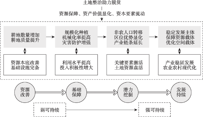
图1
土地整治助力扶贫的贡献机制
Fig. 1
The theoretical analysis of the stages of land consolidation contribution to poverty alleviation
第一阶段——资源改善阶段。通过农业工程的实施,耕地有效平整、耕地质量提升、田间道路通达、用以灌溉、排水、污染消纳、农田防护、生态保持的农业配套设施得到完善。通过新增耕地、建设高标准农田以保障区域耕地资源数量与质量,通过耕地指标交易促进区域经济发展,通过耕地资源改善与供给解决贫困地区的资源匮乏问题[32⇓-34]。此阶段的土地整治为区域脱贫奠定了资源基础。第二阶段——基础保障阶段。资源本底的改善直接提升了耕地利用效率,交通设施的完善将提高农户投入积极性,农业水利设施的完善对农作物的增产增收具有显著促进作用,耕地规模化率和机械化率均提升,灾害防护能力增强,资源利用水平的提高可为贫困区提供直接资源保障[33]。此阶段的脱贫工作依托自然资源的直接供给,以“外部造血”为主。第三阶段——潜力挖掘阶段。资源优化和设施配套为规模化和机械化种植提供条件,进而改进生产方式、优化作物种植结构。伴随政策扶植、优势气候条件、廉价劳动力等区位优势,以特色农作物产业化带动经济发展可促进多元业态有机融合、挖掘区域潜力、带动地方经济[10]。引入企业以发展特色种植业是稳定贫困人口收入、促进区域经济发展、促进青壮年返乡就业的重要举措[35]。此阶段的脱贫攻坚已增进农业农村发展动能,依靠外部输血和内部造血共同完成。第四阶段——发展持续阶段。土地整治在改善资源、挖掘区域潜力的基础上,促进区域农业结构调整和现代化农业发展[20]。从区域长期发展来看,土地可发挥其基础保障功能推进生态文明建设和农业农村现代化,实现藏粮于地战略。此阶段农民稳定就业、持续增收,农业农村发展内生动力良好,可实现区域自给式持续性发展,对推动乡村振兴具有关键作用。
从弱可持续理论出发,土地整治的脱贫作用主要依靠补充耕地数量、提升耕地质量、完善农业生产设施,以促进农业增产,解决贫困人口温饱问题,解决住房问题、满足基本生活服务。第一阶段和第二阶段以基础资源改善和外部要素支撑为发展动力,对自然资源和外部支持的依赖性较大,可持续性较弱,此时土地整治的脱贫成效是以解决温饱问题为重点,而耕地资源的消耗无法满足区域可持续减贫,土地整治带来的直接效益仍无法支撑贫困区域的长期发展;从强可持续理论出发,土地整治在优化资源本底、提高利用效率的基础上,借助土地资源的多功能性实现农业农村发展、乡村景观优化、社会繁荣稳定等衍生价值。第三阶段和第四阶段注重土地资源带来的经济和生态价值,在满足自给需求的基础上发展外部式农业以提升区域经济实力,社会经济发展不仅依托自然资源本身,更关注自然资本与外界环境空间的融合。企业引进、乡村旅游等经济发展方式的选择与转变可弥补自然资本消耗带来的空缺,与生态价值的结合增强了区域发展的可持续性。
1.2 模型构建
基于以上理论解析,土地整治在资源改善、基础保障、潜力挖掘、持续发展等强弱可持续阶段发挥作用。为明晰土地整治对区域脱贫的贡献度,对其带来的直接和间接效益提出假设。
假设一:土地整治为区域发展的直接效益提供直接支撑,弱可持续性显著。
假设二:土地整治为区域发展的间接效益提供直接支撑,强可持续性显著。
假设三:土地整治的直接效益对支撑间接效益的影响显著。
为验证以上假设,构建结构方程模型(图2)。在整治工程层面,贫困区土地整治活动的开展以新增耕地、土地平整、配套设施建设等为基础,因此拟选取新增耕地面积、新增农田防涝面积、土地平整面积、灌排设施总长度、田间道路总长度等代表土地整治工程量;已有研究证实土地整治可促进土地规模化和机械化,提升土地流转率[36]。为突出土地整治对区域脱贫的直接影响,在选取“土地流转面积”和“耕地机械化率”的基础上,以“新增农业总产值”和“耕地流转收益值”代表土地整治通过资源改善为农户带来的直接性经济收入;在间接效益层面,产业发展作为区域脱贫的重要途径,企业发展的利润和长效性可保障当地务工农户收入的稳定性。土地整治带来的资源改善为企业的引进创造了平台,加之乌蒙山片区特殊的光温水土条件,发展特色种养殖业可极大带动区域经济发展,改善贫困农民的生活质量。以“增加企业收入”“增加地方税收”和“带动企业数量”代表企业运行获得的总利润及对当地经济发展的贡献程度,以“企业就业人数”和“农民务工收入”表征企业发展为当地农民带来的经济收入,而企业的优良发展会激发外出务工劳动力的返乡意愿,以“劳动力返乡率”表征贫困区的发展活力与可持续能力。基于此,选取相关变量进行假设检验(表1)。
图2
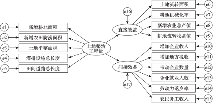
图2
土地整治对区域脱贫的贡献度模型——测量模型与结构模型
Fig. 2
The contribution model of land consolidation to poverty alleviation: Measurement model and structural model
表1 土地整治助力脱贫评价指标及释义
Table 1
| 潜变量 | 观测变量 | 指标释义 |
|---|---|---|
| 土地整治工程量 | 新增耕地面积 | 项目建设增加的耕地面积 |
| 新增农田防涝面积 | 因修建排涝沟、排涝泵站等排水设施而新增的防涝总面积 | |
| 土地平整面积 | 项目建设开展土地平整的面积 | |
| 灌排设施总长度 | 项目建成后增加的灌溉和排水设施总长度 | |
| 田间道路总长度 | 项目建成后增加的田间道路总长度 | |
| 直接效益 | 土地流转面积 | 签订土地承包及流转协议的土地面积 |
| 耕地机械化率 | 运用机械作业的耕地面积占耕地总面积的比值 | |
| 新增农业总产值 | 整治后增加的农业总产值 | |
| 耕地流转收益值 | 土地承包及流转出的耕地收入 | |
| 间接效益 | 增加企业收入 | 项目建成后引进的中小企业获得的收入 |
| 增加地方税收 | 项目建成后引进的中小企业缴纳的税金 | |
| 带动企业数量 | 项目建成后引进的企业数量 | |
| 企业就业人数 | 项目区引进企业吸纳的当地劳动力数量 | |
| 劳动力返乡率 | 企业吸纳的返乡劳动力占总劳动力数量的比例 | |
| 农民务工收入 | 项目区农民于企业务工获得的总收入 |
1.3 数据来源
1.3.1 研究区概况
本文以四川省乌蒙山连片区域土地整治重大扶贫项目为对象,以乌蒙山片区(四川省部分)作为研究区,涉及13个贫困县,地势高低悬殊,自然环境较复杂,耕地资源分布不均且利用率较低,与外界交流较为闭塞,少数民族聚居,社会稳定性较弱。重大项目自2018年实施,截至2020年12月已验收子项目55个(图3),涉及行政村194个,研究以此55个子项目为研究对象,分析土地整治对脱贫攻坚的贡献度。
图3
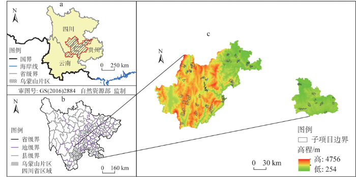
图3
研究区所在位置及项目区边界
注:本图基于自然资源部标准地图服务系统下载的标准地图制作,底图无修改。
Fig. 3
Location of the study area and the boundary of the project area
1.3.2 数据来源
以各子项目为研究对象,于2019年10月和2020年10-12月对55个竣工子项目涉及的194个村开展调研,项目区通过土地资源改善和格局优化,整治效果显著(图4),惠及贫困人口约23万,直接受益贫困人口近8万,极大地改善了贫困地区农村生产生活条件,强力助推了区域的脱贫攻坚工作。
图4
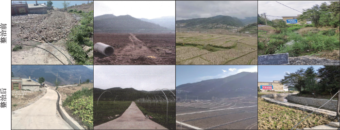
图4
部分项目区土地整治前后对比
Fig. 4
Comparison of some projects before and after land consolidation
以村为单位填写问卷,调查和访谈对象为村基层组织成员、整治项目施工单位成员、当地企业负责人和当地农户。调查内容涉及土地整治工程量、耕地利用效率、农业收益增加额、农户临时务工收入、企业收入情况等。为提高数据测度精确性,变量均为连续型变量(表2)。最终获得有效问卷189份,问卷有效率97%。
表2 变量及描述性统计
Table 2
| 变量 | 最大值 | 最小值 | 平均值 | 标准差 | |
|---|---|---|---|---|---|
| 土地整治工程量 | 新增耕地面积/hm2 | 51.047 | 0.067 | 10.972 | 9.315 |
| 农田防涝面积/hm2 | 414.6 | 0 | 36.207 | 66.947 | |
| 土地平整面积/hm2 | 648.804 | 0.126 | 113.055 | 109.812 | |
| 灌排设施总长度/km | 3459.926 | 0.011 | 34.589 | 285.232 | |
| 田间道路总长度/km | 29.522 | 0 | 5.891 | 5.349 | |
| 直接效益 | 土地流转面积/hm2 | 0.273 | 0 | 0.035 | 0.061 |
| 耕地机械化率/% | 100 | 0 | 28.723 | 27.378 | |
| 新增农业总产值/(元/亩) | 2729.48 | 0.002 | 324.198 | 319.36 | |
| 耕地流转增加额/(元/亩) | 400 | 0 | 113.3741 | 121.3906 | |
| 间接效益 | 增加企业收入/(万元/年) | 2254.3 | 3.638 | 481.869 | 431.307 |
| 增加地方税收/(万元/年) | 224.875 | 0.32 | 63.392 | 45.81 | |
| 带动企业数量/个 | 14 | 0 | 2.526 | 2.029 | |
| 企业就业人数/人 | 327 | 0 | 72.273 | 56.744 | |
| 劳动力返乡率/% | 59 | 0 | 11.927 | 9.263 | |
| 农民当地务工收入/(万元/年) | 3 | 0.005 | 1.507 | 0.79 |
注:1亩≈667 m2。
1.4 研究方法
(1)测量模型
测量模型(The Measurement Model)描述潜变量η、ξ与观测变量
式中:
(2)结构模型
结构模型(The Structural Equation Model)描述潜变量之间的因果关系,方程表达式为:
式中:
(3)参数估计
结构方程可以通过适当的估计方法估计出各观测指标对潜变量的贡献程度,以及各潜变量之间的影响路径系数。目前求解SEM以基于极大似然估计的协方差结构分析(以LISEREL方法为代表)和基于偏最小二乘法的方差分析(以PLS方法为代表)为主[40]。本文运用协方差结构分析对结构方程的参数进行估计。
(4)模型拟合效果评价指标
由于模型较注重生成的再生矩阵与初试协方差矩阵的整体相似度,即初试模型与数据资料之间的拟合度,结合绝对适配度指数、比较适配度指数、简约适配度指数等模型适配度指标,在参数估计的基础上对模型开展评估与修正(表3)。模型运行及修正借助SPSS和Amos运行。
表3 模型适配度指标及适配标准[40]
Table 3
| 指标 | 简写 | 连续变量适配标准 | 最佳适配标准 |
|---|---|---|---|
| 绝对适配度指数 | |||
| 渐进残差均方和平方根 | RMSEA | <0.06 | — |
| 适配度指标值 | GFI | ≥0.95 | 数值越大,模型适配度越佳 |
| 调整适配度指标值 | AGFI | ≥0.95 | 数值越大,模型适配度越佳 |
| 卡方自由度比值 | <3 | 比值越小,模型适配度越佳 | |
| 比较适配度指数 | |||
| 规模适配度指标 | NFI | ≥0.95可以接受 | 数值接近1模型适配度越佳 |
| 相对拟合指数 | RFI | ≥0.95可以接受 | 数值接近1模型适配度越佳 |
| 增值适配度指标 | IFI | ≥0.95可以接受 | 数值接近1模型适配度越佳 |
| Tucker-Lewis指标 | TLI | ≥0.95可以接受 | 数值接近1模型适配度越佳 |
| 比较适配度指标 | CFI | ≥0.95可以接受 | 数值接近1模型适配度越佳 |
| 简约适配度指数 | |||
| 简约调整GFI | PGFI | 数值接近1较佳,一般比其他指标值低,对模型大小敏感性较低 | 数值接近1模型适配度越佳 |
| 简约调整NFI | PNFI | 对模型大小相当敏感 | 数值越大,模型适配度越佳 |
| 简约调整CFI | PCFI | 对模型大小敏感 | 数值接近1模型适配度越佳 |
2 结果分析
2.1 信度与效度分析
信度(reliability)指对土地整治不同村采用同一数据测量方法时,所得结果的内部同构性或相似性,即测量数据结果的可靠性、一致性和稳定性。本文以内部一致性系数作为信度系数y开展信度评价,系数愈高即表示测量数据结果愈一致、稳定与可靠,一般认为数据大于0.6即代表数据可靠[40]。其公式为:
式中:
效度(validity)指问卷调查方法能反映被测量内容的准确程度,即测量数据结果的准确性、有用性。本文以内敛效度检验各潜变量下各项变量的收敛程度,以平均差异提取量(AVE)值表征内敛效度,指标数值越大,代表测量数据解释内生变量的程度越大,一般认为AVE值应至少大于0.5[41]。其公式为:
式中:
结果表明(表4),测量数据总表的信度系数为0.8,土地整治工程量、直接效益、间接效益的信度系数均大于0.6,测量数据信度较好。对三个潜变量的15项指标进行效度分析,测量模型具有较好的区分效度。
表4 信度与效度分析结果
Table 4
| 内生变量 | ||
|---|---|---|
| 土地整治工程量 | 0.64 | 0.65 |
| 直接效益 | 0.68 | 0.63 |
| 间接效益 | 0.75 | 0.70 |
2.2 模型验证与修正
为检验观测变量与潜变量间的贡献关系是否合理,借助验证性因子分析(CFA)对测量方程进验证。结果显示,存在若干指标未通过t检验,各项适配指数较低,未达到模型拟合一般标准,拟合度较低。为提高模型准确性,以参数估计值和修正指数(M.I.)为参考,对初试假设模型进行修正[42]。依据参数估计值确定参数异常和效应不显著的路径,删除模型中“灌排设施完备度→资源改善度”和“青年劳动力的返乡率→间接效益”两项路径。由于灌排设施完备度可在“新增农田防涝面积”指标中体现,综合考虑乌蒙山区水资源匮乏等问题,灌排设施对耕地产出的贡献率有待探讨。从测量数据本身来看,“青年劳动力的返乡率”均值较低,由规模化种植或企业引进带来的青年劳动力返乡人数整体较少,对比性较弱,故将两项测量指标删除,理论上可行。再次拟合得到修正模型1,结果显示,路径的删除改善了模型各项拟合指数,修正有效,但从各项适配指数来看,修正模型仍未达到模型最佳拟合度。参考M.I.进行二次模型修正,按照逐步修改的原则,应选取M.I.指数较大的路径。修正模型1的拟合结果显示,M.I.较大的路径依次为“新增耕地面积—带动企业数量”“新增农田防涝面积-新增农业总产值”“增加中小企业收入—农民务工收入”“耕地机械化率—土地流转收益增加额”。新增耕地面积可有效提升耕地集中连片程度,对企业引进具有促进作用;新增农田防涝能力可提高耕地抵御风险的能力,对耕地产出具有促进作用;企业收入与农民务工收入、耕地机械化与土地流转均具有较高相关性,故增设相关路径在理论上合理。针对参数估计值和修正指数进一步修正模型,得到修正模型2,且在各变量间已无可优化空间,拟合结果达到最佳参考标准(表5),两次修正后的结构方程模型即为最优拟合结果(图5)。
表5 路径模型的整体适配度指标统计量摘要表
Table 5
| 统计检验量 | 初始假设模型 | 修正模型1 | 修正模型2 | 参考标准 |
|---|---|---|---|---|
| 自由度 | 87 | 62 | 58 | — |
| 绝对适配度指数 | ||||
| RMSEA | 0.13 | 0.09 | 0.04 | <0.05 |
| GFI | 0.79 | 0.82 | 0.91 | >0.90 |
| AGFI | 0.62 | 0.79 | 0.93 | >0.90 |
| 1.89 | 1.92 | 1.52 | <2.00 | |
| 比较适配度指数 | ||||
| NFI | 0.65 | 0.74 | 0.97 | >0.90 |
| RFI | 0.56 | 0.65 | 0.96 | >0.90 |
| IFI | 0.71 | 0.80 | 0.96 | >0.90 |
| TLI | 0.72 | 0.84 | 0.93 | >0.90 |
| CFI | 0.58 | 0.71 | 0.92 | >0.90 |
| 简约适配度指数 | ||||
| PGFI | 0.35 | 0.54 | 0.58 | >0.50 |
| PNFI | 0.43 | 0.59 | 0.80 | >0.50 |
| PCFI | 0.51 | 0.60 | 0.83 | >0.50 |
图5
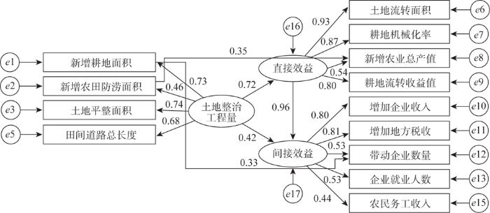
图5
土地整治助力脱贫攻坚结构方程模型的参数估计
Fig. 5
Parameter estimation of structural equation model for poverty alleviation assisted by land consolidation
2.3 土地整治对脱贫攻坚的贡献机制分析
2.3.1 弱可持续视角下的直接效益分析
模型中路径系数即变量间的影响程度,从弱可持续性理论出发,土地整治对区域发展的直接效益的总贡献效应为0.72,弱可持续性显著,假设1成立。
从外生变量来看,新增耕地和土地平整对土地整治工程量完成度的贡献度较高,田间道路次之,表明贫困区由土地整治工程带来的资源条件改善以新增耕地、土地平整、田间道路建设为主;农田防涝工程在土地整治工程中的贡献度较低。对土地整治的直接效益贡献最显著的为土地流转,表明资源改善后,短期选择耕地流转可带来较大收益。从问卷调查结果来看,由于55个子项目区之间的自然条件、社会环境等差异,土地流转带来的直接收益不等,但总体来看,流转面积和亩均流转收益对土地整治带来的直接效益贡献度较高,总效应值分别为0.93和0.80。耕地机械化率对直接效益的总效应值为0.87,表明土地平整、田间道路等整治工程建设提高了耕地利用效率。农业总产值对直接效益的支撑较低,总效应值为0.54,由耕地资源改善带来的农业总产值对区域直接效益的贡献度不高,表明土地整治带来的农业总产值增加对区域发展直接效益虽有支撑,但贡献度有待提升。外生变量之间的路径显示,农田防涝工程可促进农业总产值的提高,总效应值为0.35,表明农田防涝对促进农业增产增收具有积极作用。耕地机械化率影响耕地流转收益的总效应值为0.4,表明耕地流转亩均收益较高的区域多集中在可开展机械化耕作的区域。综合而言,土地整治带来的直接效益较为显著,耕地流转、机械化带来的土地利用效率有所提升,为贫困人口提供了基础保障,初步解决了温饱问题,但农业总产值对直接效益的贡献率不高,区域发展具有弱可持续性。
2.3.2 强可持续视角下的间接支撑机制分析
从强可持续性理论出发,土地整治对区域发展间接效益的总效应为0.42,强可持续性不显著,假设2不成立。直接效益影响间接效益的总效应值为0.96,贡献率较高,假设3成立。
从外生变量来看,企业收入和地方税收对间接效益的贡献度较高,总效应值分别为0.80和0.81,可看出企业引进对区域脱贫发挥了关键作用;农民务工收入对间接效益的影响总效应值为0.72,表明农民务工收入对区域可持续脱贫具有重要支撑作用,企业引进为当地劳动力提供了就业岗位,优化农业产业结构,促进贫困地区经济发展;带动企业数量和就业人数影响区域间接效益的总效应值分别为0.53和0.44,对间接效益的贡献度为中等水平。其中,新增耕地面积对带动企业数量的影响总效应值为0.33,表明耕地资源作为区域发展的基础性平台支撑,对企业的发展具有保障作用;增加企业收入对企业就业人数的影响总效应值为0.44,表明企业的发展与企业就业人数具有相关性,发展良好的企业对解决贫困人口的就业问题具有更大的促进作用。综合而言,企业的引进具有不同层面的支撑功能,在区域层面可增加地方税收,提升贫困区整体经济实力,在农户层面可提供就业岗位,提高贫困人口经济收入,从农业农村长期发展来看,企业引入对优化农业产业结构、延长产业链条、改进农业生产方式、维持社会稳定有一定促进作用,具有强可持续发展性质。
3 结论与讨论
3.1 结论
从土地整治对脱贫攻坚的贡献关系入手,借助强—弱可持续理论,解析土地整治对脱贫攻坚不同发展阶段的贡献机制,形成土地整治助力脱贫的理论框架。以四川省乌蒙山片区土地整治重大扶贫项目为例,借助结构方程模型构建土地整治对区域脱贫的贡献度模型,揭示土地整治各要素间的相关关系,并解析各要素对区域发展间接效益和直接效益的贡献程度,为贫困区域可持续脱贫工作的开展提供决策支持,为国土空间规划背景下的全域国土综合整治和乡村振兴战略提供参考建议。研究结果表明:
(1)土地整治可直接支撑脱贫攻坚的直接效益,但对区域发展的间接效益贡献度不足。结果方程模型结果显示,土地整治工程对脱贫攻坚产生直接效益的总效应值为0.72,贡献于间接效益的总效应值为0.42,表明土地整治对直接效益发挥的贡献度较强,对间接效益发挥的贡献度较弱,土地整治带来的资源改善可短期解决贫困人口温饱问题,但无法满足贫困区长期可持续发展的脱贫目标。乌蒙山区集自然、经济、社会等多维贫困于一身,土地整治对资源本底的改善较为明显,但间接效益的发挥需依靠资源的改善与优化对农业农村各发展要素的激活,现行标准下农村贫困人口全部脱贫后,更应注重土地整治的建后管护与关键发展要素的挖潜。
(2)土地整治为脱贫带来的直接效益对区域发展的间接效益贡献度较大。结构方程模型结果显示,直接效益对间接效益的影响总效应值为0.96,土地整治工程带来的资源改善和设施完备可提高农户对农地投入的积极性,进而提高土地利用效率,直接效益的发挥对后续企业引进、特色产业、农业农村现代化等间接效益的发挥具有重要推动和支撑作用。整体来看,贫困区应在土地整治的基础上,统筹“人—地—业”三要素,激活和培育贫困区发展新动能,在直接效益发挥的基础上,形成具有区域发展特色的乡村新业态。
(3)土地整治各要素对资源初期改善度及直接、间接效益的贡献率具有一定差异。在资源初期改善层面,新增耕地和土地平整带来的贡献度较大,最小为农田防涝面积,表明新增耕地可在较大程度上改善贫困区的耕地资源条件,反映出贫困区人均耕地不足的现象;土地流转和机械化程度对直接效益的贡献度较大,农业总产值的贡献度最小,表明在直接效益层面,资源改善为贫困人口带来的基础保障以自给式农业为主,农业商品化程度较弱;企业收入和税收对间接效益的贡献度较大,企业就业人数的贡献度最小,由于引进的企业尚处于发展初期,土地整治带来的间接效益有待进一步挖掘与发挥,后期发展应稳定贡献度较大的因素,关注贡献度较小的因素,以最大程度发挥土地整治对可持续脱贫的贡献度。
3.2 讨论
土地整治作为脱贫攻坚的有力推手,在完成“消除绝对贫困”这一艰巨任务中发挥了重要作用。随着土地整治内涵的不断演进,其在激活贫困区域发展关键要素、引领贫困乡村发展方向、调控区域人地关系等方面发挥关键作用[21,43,44]。本文基于强—弱可持续理论形成了土地整治助力脱贫的理论机制,在分析土地整治效益的基础上,定量解析各相关要素对区域脱贫的贡献效应,提出整治项目后期管护的关键要素与重点方向。土地整治以资源改善为基础,为乌蒙山地区提供直接效益的同时,也为区域可持续脱贫提供间接支撑。在“强—弱”可持续视角下,乌蒙山区特殊的气候环境和区位条件决定了区域脱贫的难度与复杂性。弱可持续发展方式难以维持区域脱贫成果,通过资源优化、产业配置有效发挥土地整治扶贫的强可持续性是区域脱贫的关键。
土地整治在盘活土地资源的基础上,对贫困区社会稳定、文化与生态文明建设具有重要推动作用,土地资源在统筹贫困地区物质空间与精神内核、实现“人—地—业”协调发展的过程中提供支撑与保障,以提升脱贫攻坚的强可持续性。因此,土地整治要素的综合性和广泛性为可持续脱贫带来的衍生价值仍值得深入研究。以乌蒙山片区为代表的深度贫困区,其复杂的自然及社会条件是限制区域强可持续发展的重要因素,如何有效规避不利因素并最大化发挥区域优势和土地整治的间接效益是可持续脱贫的关键。因此,内外部要素对土地整治效益发挥的限制性与不确定性仍是下一步研究重点。消除贫困作为社会主义的本质要求,不仅是经济发展的必然趋势,也是一项重要的政治任务[45,46]。在土地整治助力扶贫过程中,政治优势和社会主义制度优越性对土地整治效益的发挥具有重要保障作用,效益的发挥不仅体现了土地资源的多功能性,也是政府、市场、社会等多重力量共同作用的结果,行业扶贫、专项扶贫、社会扶贫等多主体参与对土地整治脱贫效益发挥的协同作用是消除绝对贫困的关键[47]。
由于该项目处在整治工程完成初期,效益发挥具有一定局限性和时限性,本文以整治前后相关变量的增量表征工程建设成效及对扶贫的贡献度,但在强可持续理论视角下,长时间序列多维监测项目扶贫效益的发挥仍是深化土地整治脱贫机制解析与定量评估的关键,后续研究将对项目效益发挥开展动态性监测与数据收集。此外,本文重点关注土地整治项目建成后区域整体性发展与农户脱贫问题,侧重于土地整治工程效益的发挥,且深度贫困区的扶贫工作以发展带动式扶贫为主,以贫困人口和贫困区域的脱贫为重点[45],未考虑基于投入产出的生产效益问题。由于土地整治重大工程不同于一般土地整治项目,数据收集时间恰处在全面脱贫的最后阶段,社会各界对项目区投入较大,但本文重点关注农户及区域通过整治项目获得的收益,数据收集仅考虑重大工程所涉及的项目建设活动本身,未考虑政府和社会各界对深度贫困区的投入与扶持,在项目投入成本方面,由于资金来源较广泛,涉及多部门多渠道,数据收集具有一定难度。后续研究将拓宽数据收集渠道,综合考虑多重投入视角下的土地整治扶贫机制与效益,进一步开展后脱贫时代的土地整治效益研究。
参考文献
Transforming our world: The 2030 agenda for sustainable development
世界贫困的时空演化格局及关键问题研究
Spatial-temporal pattern of world poverty reduction and key problems analysis
DOI:10.3724/SP.J.7101866531 URL [本文引用: 1]
中国农村多维贫困地理识别及类型划分
DOI:10.11821/dlxb201506012
[本文引用: 4]

发展多维贫困度量方法和提高贫困识别精准度是近年国际贫困研究中的热点领域,也是中国未来提高农村扶贫实践质量和效率所面临的关键问题。本文借鉴国际上关于脆弱性—可持续生计框架模型在贫困研究中的学术思想,通过建立农村多维贫困测度指标体系和地理识别方法,对中国农村开展了县域尺度的贫困地理识别,并与单维度收入贫困以及国家最新认定的扶贫开发重点县进行了对比分析,最后对识别的多维贫困县按扶贫措施相似性进行了类型划分。研究结果表明:655个县级单元被识别为多维度贫困县,涉及农村人口1.41亿人;空间分布集中连片特征显著,青藏高原及其周边的南疆三地州、黄土高原西部、滇西—川西高山峡谷区为最大的连片贫困区;有71.79%的国家重点贫困县与识别结果重叠,与国家重点贫困县对比,识别的多维贫困县在各单维度和综合维度都处于更劣势水平;多维贫困县被划分为金融资本缺乏型、人力资本缺乏型、基础建设缺乏型、金融基建兼缺型、人力基建兼缺型、生计途径缺乏型、生存条件缺乏型和发展条件缺乏型8种类型。
Geographical identification and classification of multi-dimensional poverty in Rural China
DOI:10.11821/dlxb201506012
[本文引用: 4]
Developing methods for measuring multi-dimensional poverty and improving the accuracy of poverty identification have been the hot topics in international poverty research for decades. In light of the academic thoughts of the vulnerability and sustainable livelihood analysis framework, this paper establishes an index system and a method for geographical identification of multi-dimensional poverty, and carries out a county-level identification in rural China. Furthermore, this study makes a comparison between the identification result, income poverty and the latest designated poor regions by the Chinese government. At last, the identified multi-dimensional poor counties are classified by the similarity of poverty reduction measures. The results show that: (1) Taking the vulnerability and sustainable livelihood analysis framework proposed by DFID as theoretical basis, we build an index system of multi-dimensional poverty identification to reflect the farmers' livelihoods that multiple factors work on. It is feasible to develop a composite Multi-dimensional Development Index (MDI) for the integrated method of geographical identification of multi-dimensional poverty in rural China. (2) A total of 655 counties are identified as multi-dimensional poor counties. They are concentrated and jointly distributed in space, in which the Tibetan Plateau and its neighboring areas of three prefectures in southern Xinjiang, western Loess Plateau, mountainous and gully areas in western Yunnan and Sichuan, are suffering greatly from poverty. Besides, poor counties are mainly in Wumeng-Daliang mountainous areas, Yunnan-Guizhou-Guangxi rocky desertification areas, border mountainous areas in Yunnan, Wuling mountainous areas, Qinling-Daba mountainous areas, Shanxi-Shaanxi gully areas and Yanshan-Taihang mountainous areas. (3) In comparison to the latest designated poor counties, this paper targets at poor counties with more disadvantages at both single and multiple dimensions. Some 71.79% of designated poor counties overlap with identified poor counties. By contrast, the majority of the designated poor counties located in mountainous areas of central or eastern China do not belong to identified poor counties because of much less disadvantage/deprivation dimensions. However, the identified poor counties, which are mainly distributed in marginal areas of plateau or mountainous areas in western China, and suffering from multiple dimensions of disadvantages and deprivations, are not included in the designated poor counties. (4) According to the disadvantage/deprivation situation of different dimensions, multi-dimensional poor counties are classified into eight types, i.e., lack of financial capital, lack of human capital, lack of infrastructure, lack of both financial capital and infrastructure, lack of both human capital and infrastructure, lack of means/strategies of livelihoods, lack of living condition, and lack of development condition.
中国长期减贫, 路在何方: 2020年脱贫攻坚完成后的减贫战略前瞻
Where is the way for China to reduce poverty for a long time? Prospects for poverty reduction strategies after the completion of poverty alleviation in 2020
贫困地区的精准扶贫与乡村振兴: 内在逻辑与实现机制
DOI:10.11821/dlyj020190644
[本文引用: 1]
面向“两个一百年”奋斗目标的需要,当前中国贫困地区乡村发展正逐渐由低层次的脱贫向更高层次的振兴转变,两者的紧密关联使得减贫对于推动乡村振兴战略目标的实现具有重要意义。通过分析精准扶贫与乡村振兴的基本内涵,探讨两者的内在逻辑关系,进而从多个维度剖析贫困地区的精准扶贫实践如何助推其乡村振兴。结果表明:① 贫困地区的精准扶贫旨在科学诊断致贫因子的基础上采取针对性措施实施帮扶,从根本上消除导致贫困的各种障碍性因素;乡村振兴则重点在于通过构建城乡融合发展的体制机制,最终实现农业农村的现代化。② 精准扶贫与乡村振兴的内在一致性使得两者存在紧密的逻辑顺承性,精准扶贫是乡村振兴的关键和基本前提,而乡村振兴是精准扶贫的深化和保障,可以说农村减贫的过程也是乡村逐步振兴的过程。③ 通过要素资源合理流动和配置补齐乡村人、地、业等发展短板,贫困地区重塑了要素耦合、结构合理、功能复合的乡村地域系统,从而推动乡村产业、人才、文化、生态、组织等振兴,最终实现农业强、农民富和农村美的发展目标。
Targeted poverty alleviation and rural revitalization in poverty-stricken areas: Internal logic and mechanism
DOI:10.11821/dlyj020190644
[本文引用: 1]
Targeting at the needs of Two Centenary Goals, rural development in poverty-stricken areas of China is gradually transforming from poverty alleviation to rural revitalization. Since there is a close relationship between these two stages, targeted poverty alleviation practices in rural areas are of great significance to promote the realization of rural revitalization. This study analyzed the connotations of targeted poverty alleviation and rural revitalization, and investigated the internal logic between them. Then it discussed how antipoverty practices promote the rural revitalization in poverty-stricken areas. Results show that targeted poverty alleviation aims at taking countermeasures to help those who truly need them based on scientific diagnosis of the factors leading to poverty, thus all kinds of factors causing poverty can be eliminated fundamentally. The key of rural revitalization lies in establishing the system and mechanism for urban-rural integrated development, eventually realizing the modernization of agriculture and countryside. In term of the relationship between targeted poverty alleviation and rural revitalization, the former is the key and basic premise of the latter since poverty reduction guided by targeted poverty alleviation makes up the shortboard of rural development, and the latter is the higher stage and guarantee of the former since it steadily improves the abilities of rural sustainable development. Therefore, it can be said that the process of poverty alleviation in rural areas is also a process of gradual rejuvenation of the countryside. Through the rational flow and allocation of factors, such as human, land and capital, poverty-stricken areas have constructed a benign rural regional system with enough elements, proper structure and multiple functions to promote the revitalization of industries, talent, culture, ecology and organizations. Eventually, it helps to achieve the goals of strong agriculture, beautiful countryside and well-off farmers. Rural development has obvious path dependence; thus, its cyclic accumulation effect determines that the current antipoverty in poor areas should focus on the effective connection with rural revitalization, laying a solid foundation for rural sustainable development.
Spatio-temporal patterns of rural poverty in China and targeted poverty alleviation strategies
DOI:10.1016/j.jrurstud.2017.04.002 URL [本文引用: 1]
Land consolidation boosting poverty alleviation in China: Theory and practice
DOI:10.1016/j.landusepol.2018.12.024 URL [本文引用: 1]
System-dynamic analysis on socio-economic impacts of land consolidation in China
DOI:10.1016/j.habitatint.2016.05.007 URL [本文引用: 1]
Satellite data indicates multidimensional variation of agricultural production in land consolidation area
DOI:10.1016/j.scitotenv.2018.10.415 URL [本文引用: 3]
Poverty dynamics, ecological endowments, and land use among smallholders in the Brazilian Amazon
DOI:10.1016/j.ssresearch.2013.09.002
PMID:24267754
[本文引用: 1]
Rural settlement in previously sparsely occupied areas of the Brazilian Amazon has been associated with high levels of forest loss and unclear long-term social outcomes. We focus here on the micro-level processes in one settlement area to answer the question of how settler and farm endowments affect household poverty. We analyze the extent to which poverty is sensitive to changes in natural capital, land use strategies, and biophysical characteristics of properties (particularly soil quality). Cumulative time spent in poverty is simulated using Markovian processes, which show that accessibility to markets and land use system are especially important for decreasing poverty among households in our sample. Wealtheir households are selected into commercial production of perennials before our initial observation, and are therefore in poverty a lower proportion of the time. Land in pasture, in contrast, has an independent effect on reducing the proportion of time spent in poverty. Taken together, these results show that investments in roads and the institutional structures needed to make commercial agriculture or ranching viable in existing and new settlement areas can improve human well-being in frontiers. Copyright © 2013 Elsevier Inc. All rights reserved.
集成“质量—格局—功能”的中国耕地整治潜力综合分区
Comprehensive zoning of cultivated land consolidation potential integrating "quality-pattern-function" in China
土地扶贫的减贫效应及实现路径分析: 基于土地资源“三位一体”属性视角
Analysis on poverty reduction effect and realization path of land poverty alleviation: Based on the "Trinity" attribute of land resources
县级多维贫困度量及其空间分布格局研究: 以连片特困区扶贫重点县为例
DOI:10.13249/j.cnki.sgs.2013.012.1489
[本文引用: 1]
贫困人口及其分布区域的有效瞄准和识别是新阶段连片特困区农村扶贫开发需要解决的首要问题。从多维角度把握贫困的实质并进行多维贫困的具体度量和分析成为近年来国内外研究的焦点。在系统设计多维贫困识别指标体系及多维贫困测算算法流程的基础上,以河南省南阳市连片特困区扶贫重点县为研究区域,构建基于“双临界值”的“维度加总/分解”算法进行了“县级-村级”的贫困人口多维贫困量算和分析;借助Kriging法对村级多维贫困测算结果进行空间插值处理,系统分析研究区多维贫困状况空间分布格局。结果显示:研究区多维贫困发生率和多维贫困指数都呈现“西高东低”趋势,其中,内乡县和淅川县的综合贫困指数MPI最大,镇平县MPI最小。其主要致贫因素为收入和健康,收入指标对贫困的贡献度在空间上呈现“西北-东南”条带状分布,健康问题集中在镇平县;次要致贫因素为教育年限、儿童入学率以及燃料类型。此外,淅川县山区地区多维贫困发生率最高,县城附近的MPI相对较低。
Multidimensional poverty measurement and spatial distribution pattern at the country scale: A case study on key country from national contiguous special poverty-stricken areas
区域多维贫困测量的理论与方法
DOI:10.11821/dlxb202004007
[本文引用: 1]
贫困包括区域贫困和个体贫困,两者均具有多维属性。区域多维贫困是贫困地理学研究的重要内容,深度贫困地区是区域多维贫困的集中表现,是当前和未来脱贫攻坚的贫中之贫、困中之困、坚中之坚。本文以空间贫困理论为基础,界定了贫困地域系统和区域多维贫困的概念,并探究了区域多维贫困测度指标体系与评估方法。据此,以中国334个深度贫困县为研究对象,运用BP神经网络模型和ESDA技术刻画了中国深度贫困地区的多维贫困空间格局。结果表明:① 区域多维贫困是贫困地域系统发展演化过程中“人”“地”“业”三个核心要素耦合失调的一种外在表现形式,是特定地域在生态环境劣势、经济劣势、社会福利劣势上的综合表现,包括生态贫困、经济贫困和福利贫困3个维度。② 深度贫困地区最“深”的地方在青藏高原,最“深”的短板在公共服务和基础设施。从单一维度的贫困指数来看,深度贫困地区的福利贫困指数(WPI)>经济贫困指数(EPI)>生态贫困指数(NPI),三者平均值分别为2.77、2.66、1.89,贫困人口社会福利供给不足和公共服务短缺是深度贫困地区最突出的问题;从多维贫困指数来看,青藏高原是区域多维贫困指数(RMP)的高集聚区或热点区,生态贫困、经济贫困和福利贫困程度均显著高于其他地区。③ 区域多维贫困指数能较好地揭示特定区域的贫困状况。在地理位置偏远、生态环境极其脆弱、区域劣势突出的地区,区域贫困和个体贫困在空间上高度重叠。
Theory and measurement of regional multidimensional poverty
DOI:10.11821/dlxb202004007
[本文引用: 1]
Poverty includes regional poverty and individual poverty, both of which are featured by multidimensional concept. Regional multidimensional poverty (RMP) is a major theme and content in poverty geography. Because of harsh natural environment, vulnerable economy and inadequate public services, severely impoverished areas (SIAs) are typical and highlighted areas of RMP, which have been the biggest obstacle to poverty alleviation in China. Based on the theory of spatial poverty, this paper defines the notion of impoverished areal system (IAS) and regional multidimensional poverty (RMP), explores their internal connections and proposes the evaluation indictors and measurement method for RMP. Taking 334 severely impoverished counties as research samples, we analyze the multidimensional poverty patterns of SIAs in 2016 by BP neural network model and exploratory spatial data analysis (ESDA). Results show that: (1) RMP is an external manifestation of the coupling imbalance of "human", "environment" and "industry" in the evolution of IAS. It reveals regional disadvantages in natural environment, economic development and social welfare, corresponding to natural poverty, economic poverty and welfare poverty, respectively. (2) The most severely impoverished county, with the poorest services and infrastructure, is found in the Qinghai-Tibet Plateau. From a single dimension of regional poverty, the Welfare Poverty Index (WPI) > Economic Poverty Index (EPI) > Natural Poverty Index (NPI) in the SIAs, whose average is 2.77, 2.66 and 1.89, respectively, indicating that the lack of social welfare and public services for the poor has become the prominent problem in the SIAs. From the perspective of multidimensional poverty, the Qinghai-Tibet Plateau is a high agglomeration region or "hot spot" of RMP, which is significantly higher than other areas in terms of natural poverty, economic poverty and welfare poverty. (3) Both RMP and individual multidimensional poverty are effective measures of poverty targeting. Their matching coefficient (M) can help us to judge the poverty status of some specific areas, e.g., RMP is superior to individual multidimensional poverty in the remote areas, extremely fragile ecological environment and obvious regional disadvantage, where the matching coefficient (M) is higher. RMP can more objectively reflect the true level of geographical capitals, effectively target poor areas and identify determinant impoverishing factors.
扶贫用地: 从政策供给到制度建立
Poverty alleviation land: From policy supply to system establishment
农户生计资本禀赋对不同模式农地整治增收脱贫的影响: 以湖北恩施和贵州毕节为例
Impact of rural households' livelihood capital endowment on poverty alleviation and income increase of rural land consolidation in different modes: Evidence from Enshi, Hubei province and Bijie, Guizhou province
土地整治促进贫困地区脱贫的模式及实证
Patterns of land consolidation promoting poverty alleviation in poor areas and its application
西南山区土地利用多功能与多维贫困的时空耦合关系
Spatio-temporal coupling relationship between multi-functionality of land use and multidimensional poverty in China's Southwestern Mountainous Areas
中国精准扶贫土地整治的典型模式
DOI:10.11821/dlyj020180315
[本文引用: 2]
土地整治是助推精准扶贫,实现脱贫解困的重要途径。根据土地整治作用于农村减贫发展的实现路径,将全国土地整治助推精准扶贫的典型模式概括为四种:① 单项土地整理模式。通过开发低效未利用地,建设高标准农田,改善农业生产条件,促进农业规模化经营。② 三生空间优化模式。将农村宅基地复垦与易地扶贫搬迁相结合,改善人居环境,恢复脆弱生态,优化乡村三生空间。③ 土地资产显化模式。实施补充耕地指标有偿异地调剂,积累扶贫开发资金,促进城乡要素双向流动,统筹城乡发展。④ 土地资本流动模式。将土地整治与土地流转及作价入股相结合,整合贫困地区劳动力、资本等要素资源,推动农业现代化和乡村振兴。
Typical models of land consolidation for poverty alleviation
DOI:10.11821/dlyj020180315
[本文引用: 2]
Poverty is an obstacle for rural revitalization and development. As the largest developing country in the world, China has been struggling against poverty for decades and has achieved a great success. Land consolidation is regarded as an indispensable path to poverty alleviation in rural China, where residents are suffering from agriculture recession such as fragmentation of arable land, soil impoverishment, and infrastructure damage, etc. According to the path in promoting poverty alleviation, land consolidation can be categorized as four typical models. Firstly, the key of land consolidation is to increase the amount of arable land and improve the conditions of agricultural production. And land consolidation is generally composed of exploiting uncultivated land, levelling uneven land, merging scattered land as well as constructing irrigation and drainage facilities. Then poor peasants can obtain concentrated and contiguous farmland equipped with improved infrastructures and roads, which makes contribution to agriculture mechanization and large-scale operation. This kind of project is categorized as "Elementary Land Consolidation Model". In addition, impoverished people usually live in mountainous areas or remote valleys, featured by inconvenient transportation and fragile ecology. Therefore, it is important to resettle these people and restore the fragile eco-environment so that peasants can enjoy livable residential space, convenient production space and sustainable ecological space. Considering the multifunction of land consolidation for optimizing rural production, living and ecological spaces, this kind of project is named "Reconstruction of Three Spaces Model". Although there is sufficient land space for construction in rural areas, cities are short of construction land for further expansion. Accordingly, a new scheme was innovated that peasants can reclaim rural settlements to increase arable land, and urban departments can buy these quotas to obtain more construction land. In this way, rural departments acquire additional capital for poverty alleviation and economic development. This new project is named "Mobilizing Land Assets Model" as it can turn rural land into actual property and bring revenues to farmers. Furthermore, rural areas also face another obstacle on the way to prosperity except for capital, that is the enormous labor flow from rural areas into cities. A large quantity of farmland has been abandoned due to the lack of adequate labors, resulting in agriculture decline and rural poverty. To resolve these rural issues, farmers are encouraged to transfer their land use rights to rural collective economic organization with identifying them as stockholders. Then the transferred land is leased to professional enterprises or farmers which will bring profits to local farmers. During this process, land plays a role of stock capital, so this project is named "Land Capitalization Model". In general, land consolidation integrated with land rights transaction conduces to agriculture modernization and rural revitalization. Nonetheless, there are still some problems during land consolidation which need to be addressed, including the single financing channels, the absence of supporting system and the lack of advanced planning. The governments are supposed to take measures to promote land consolidation in poor rural areas, such as expanding financing channels, establishing perfect supporting system, and enhancing advanced planning.
The effect on poverty alleviation and income increase of rural land consolidation in different models: A China study
中国消除绝对贫困的经验解释与2020年后相对贫困治理取向
An explanation of China's experience in eliminating absolute poverty and the orientation of relative poverty governance in the post-2020 era
农户视角下土地整治与减贫满意度: 基于5省区869户农户的实证分析
Land consolidation and satisfaction of poverty reduction from the perspective of farmers: An empirical analysis of 869 farmer households in five provinces
贫困山区农户人力资本对生计策略的影响研究: 以四川省凉山彝族自治州为例
DOI:10.18306/dlkxjz.2019.09.002
[本文引用: 1]
人力资本是构建农户生计的关键要素,从人力资本视角探讨农户生计选择对于推动农户生计转型、实现乡村振兴具有重要意义。论文以西南贫困山区四川省凉山彝族自治州为案例区,采用2018年508个农户样本数据,应用回归模型,估算了人力资本对农户生计策略的影响。结果表明:人力资本是山区农户生计选择的重要影响因素,不同类型人力资本对农户生计策略的影响不同,且具有明显的空间差异。教育文化、健康状况对非农生计策略的选择具有正向影响,且高山区>二半山区>河谷区,健康状况对河谷区农户生计选择影响不显著;非农技能培训对非农生计策略选择具有显著的正向影响,且高山区>二半山区>河谷区;农业技能培训对非农生计策略选择具有负向影响,且高山区
Influence of human capital on the livelihood strategy of farming households in poor mountainous areas: A case study of Liangshan Yi Autonomous Prefecture of Sichuan, China
DOI:10.18306/dlkxjz.2019.09.002
[本文引用: 1]
Human capital is the key factor for building farmers' livelihoods and examining farming households' livelihood strategy is important for promoting livelihood transformation and rural revitalization. Taking Liangshan Prefecture of Sichuan Province in the mountainous area of southwest China as the case study area, this study measured the impact of human capital on farming households' livelihood strategy by using the survey data from 508 farmers in 2018 and applying regression models. The results show: human capital is an important factor of farmers' livelihood choices in mountainous areas, and different types of human capital have different impacts on farmers' livelihood strategy, with clear spatial differences. Education level and health condition have positive effects on off-farm livelihood strategy, with most significant impacts in the high mountain villages, followed by the semi-mountain villages, and health condition has no significant effect on farmers' livelihood choices in the river valley villages. Off-farm skill training has a significant positive impact on off-farm livelihood strategy choices, with most significant impact in the high mountain villages, followed by the semi-mountain and river valley villages; agricultural skill training has a negative impact on off-farm livelihood strategy choices, with most significant impact in the river valley villages, followed by the semi-mountain villages, and agricultural skill training has no significant effect on farmers' livelihood choices in the high mountain villages. Young adult labor force tend to choose off-farm livelihood, and the aging problem of farming population is getting worse, with the high mountain villages being the most significant, followed by the semi-mountain villages, and the river valley villages being less obvious. Income gaps between farm and off-farm livelihood types is the fundamental reason affecting farmers' livelihood choices, and poor rural public services and lack of development opportunity are important reasons that affect farmers' livelihood choices. Finally, based on the above conclusions, this article explored the dialectical relationship between human capitals, labor off-farm employment, and rural development and its policy implications.
A longitudinal study of agriculture households in Indonesia: The effect of land and labor mobility on welfare and poverty dynamics
深度贫困地区脱贫攻坚与乡村振兴统筹衔接路径研究: 凉山彝族自治州的数据
The mechanism and promotion path on integrated linkage between poverty alleviation and rural revitalization in deep poverty stricken areas: Data from Yi Autonomous Prefecture of Liangshan
The influences of aging population and economic growth on Chinese rural poverty
DOI:10.1016/j.jrurstud.2015.11.002 URL [本文引用: 1]
可持续发展理论研究的两种范式述评
A review of two paradigms of sustainable development theory
中国土地整治转型发展战略导向研究
Strategy orientations of transformation development: Land consolidation in the new period of China
论土地整治与乡村空间重构
目前,中国新型工业化、城镇化和农业现代化的推进仍缺乏重要抓手和空间支撑平台,严重影响了城乡一体化发展进程。亟需通过开展农村土地综合整治,重构乡村生产、生活和生态空间,为推进新农村建设和城乡一体化发展搭建新平台。本文在界定了乡村空间重构,即在快速工业化和城镇化进程中,伴随乡村内生发展需求和外源驱动力综合作用下导致的农村地区社会经济结构重新塑造,乡村地域上生产空间、生活空间和生态空间的优化调整乃至根本性变革的过程,及其产业发展集聚、农民居住集中和资源利用集约3 个方面内涵的基础上,分析了工业化和城镇化进程对乡村生产、生活和生态空间的影响;探讨了乡村空间重构的土地整治类型及助推机制;结合农用地整治、"空心村"整治和工矿用地整治提出了乡村生产、生活和生态空间重构的模式与途径,以及依托土地整治的以"自下而上"为主、"自上而下"为辅的乡村空间重构战略。作为城乡一体化发展根基的乡村空间其重要性和基础平台作用应受到足够重视,乡村集约高效的生产空间、宜居适度的生活空间和山清水秀的生态空间的优化重构,有赖于区域农村土地整治工程技术、政策机制与模式的创新。
Land consolidation and rural spatial restructuring
Currently, the implementation of new type industrialization, new type urbanization and agricultural modernization strategy lacks of a major hand grip and spatial sustain platform, due to long-term existed "dual-track" structure of rural-urban development in China as well as unstable rural development institution and mechanism and backward rural and agricultural infrastructures, which greatly affects the advancement of urban-rural integration development. It is necessary to restructure rural production, living and ecological space by carrying out land consolidation, so as to establish a new platform for building new countryside and realize urban-rural integration development in China. This paper develops the concept and connotation of rural spatial restructuring, i.e., an optimization and adjustment even utterly changing process of rural production, living and ecological space accompanied by rural socio-economic structure reshaping under the pressure of rapid industrialization and urbanization. The connotations of rural spatial restructuring involve three aspects of assembling industrial development, centralizing farmers' living and intensive resources utilization. Based on the effects analysis of industrialization and urbanization on rural production, living and ecological space, this paper also probes the mechanism which push forward rural spatial restructuring by carrying out land consolidation, an important approach to supplying cultivated land, revitalizing the stock land, optimizing rural-urban land, utilizing land intensively, and increasing land productivity. A conceptualization of the models of rural production, living and ecological environment spatial restructuring is analyzed in combination with agricultural land consolidation, hollowed villages consolidation and industrial and mining land consolidation. Finally, the author argues that a "bottom-up" restructuring strategy accompanied by a few "top-down" elements is helpful for smoothly pushing forward current rural spatial restructuring in China. The optimization and restructuring of rural intensive and high-efficient production space, suitable living space with amenity and ecological space with beautiful mountain and clean water will rely on the innovation of regional engineering technology, policy mechanism and mode of rural land consolidation, and more attentions should be paid to rural space, the foundation base and platform for realizing urban-rural integration development.
江苏省耕地细碎化评价与土地整治分区研究
DOI:10.13249/j.cnki.sgs.2019.05.013
[本文引用: 1]
在明确耕地细碎化内涵空间尺度特征的基础上,从资源规模性、空间集聚性和生产便利性3方面构建耕地细碎化空间测度体系,以江苏省为例,综合运用地理空间分析、数理统计分析等方法,开展了省域尺度耕地细碎化多维评价及相应的土地整治协同探讨。研究表明:① 江苏省资源规模属性值总体偏低,呈现苏北-苏中-苏南逐级递减的分异格局;空间集聚属性值总体较高,但区域差异明显,高值区主要集中在徐淮平原及里下河平原地区;利用便利属性值总体呈现与资源规模及集聚状况相反的格局特征,苏南明显高于苏中和苏北地区,两极分化明显,地域差异较大;② 在乡镇尺度对各分维属性进行耦合形成江苏省耕地细碎化指数,省域尺度下该指数呈现从北到南逐渐增加的格局特征,表现为北部的低值聚集区和西南部的高值聚集区;③ 基于区域耕地细碎化不同属性特征的层次组合特点,全省可划分为利用提升区、集约归并区、设施改造区、规模流转区、资源优配区和综合整治区6种类型分区,据此提出不同分区土地整治的主要整治方向及关键问题。
Evaluation of cultivated land fragmentation and guidance of land consolidation at provincial Level
DOI:10.13249/j.cnki.sgs.2019.05.013
[本文引用: 1]
The macro social security function of cultivated land resources and the livelihood maintenance function of micro farmers determine that the connotation and characteristics of the fragmentation of cultivated land are quite different in different spatial scales. In view of the fact that the connotation of cultivated land fragmentation is single, the spatial index measurement is limited, and few attention has been paid to the regional differences in land consolidation, such as the characteristics and spatial distribution of cultivated land resources. This study takes a case study in Jiangsu Province, and constructs an evaluation system of cultivated land fragmentation from aspects such as resource scale, spatial agglomeration and production convenience which based on the definition of spatial scale characteristics of the connotation of cultivated land fragmentation. The results show that: 1) The value of resource scale is generally low, showing a pattern of gradual decline from north to south in Jiangsu; The value of spatial agglomeration is generally high, but the regional differences are obvious, and the high value areas are mainly distributed in Xuhuai Plain and Lixiahe Plain; The value of convenience property was significantly higher in southern than that in central and northern of Jiangsu Province, and the regional differences are obvious; 2) At the township scale, the fractal dimension of cultivated land was coupled to form the index of cultivated land fragmentation in Jiangsu Province. The index showed a gradually increasing pattern from north to south under the provincial scale, which was characterized by the low value aggregation areas in the north and the high value aggregation areas in the southwest; 3) Combined with the characteristics of different attributes of cultivated land fragmentation, Jiangsu Province has been classified into six categories: the utilization efficiency improvement area, the intensive merging area, the facility reformation area, the scale circulation area, the resource optimization area and the comprehensive consolidation area. The study can provide a useful reference for identifying the problems of regional cultivated land resource, determining the key direction of land consolidation, and making the consolidation plans for the stage.
土地整治项目区耕地资源优化配置研究
Optimized allocation of cultivated land in land consolidation project area based on multi-objective linear programming
DOI:10.31497/zrzyxb.20190404 URL [本文引用: 2]
山地村域耕地压力与农村贫困耦合协调性分析
Coupling coordination relationship between village-level cultivated land pressure and rural poverty in mountainous areas
产业精准扶贫作用机制研究
The mechanism of the industrialization of precise poverty alleviation
农村土地整治对促进农业现代化水平的影响分析
The impact of rural land consolidation program on promoting the level of agricultural modernization
贫困村空间分布及影响因素分析: 以乌蒙山连片特困区为例
DOI:10.11821/dlyj020180024
[本文引用: 1]
针对目前贫困分布研究以大尺度为主而缺乏对小尺度的关注和致贫因素分析忽略个体效应或背景效应的不足,基于空间贫困视角,以乌蒙山片区为研究区域、贫困村为研究对象,运用空间点模式分析方法探究贫困村空间分布特征,并设计多层线性回归模型从贫困村和县域两个层面综合定量剖析贫困影响因素。研究发现:① 贫困村的空间聚集特征较为明显,总体分布呈现大分散小集中、散点-极核-轴带-团块并存的空间格局。② 贫困村的贫困程度受多层因素的显著影响。其中,村级影响因素为:人口密度、通路率、劳动力比例、遭受自然灾害频次、安全饮用水比例;县级影响因素为:人均地方生产总值、高中阶段毛入学率、植被覆盖率。③ 农村贫困来源于贫困村与县域的双重作用。因此在精准扶贫工作中,政府及相关部门可针对不同尺度对象有针对性地施策,合理配置扶贫资金。
Analyzing spatial distribution of poor villages and their poverty contributing factors: A case study fromWumeng Mountain Area
乌蒙山集中连片少数民族困难地区贫困的脆弱性探讨
Discussion on the vulnerability of poverty in the difficult minority areas concentrated in Wumeng Mountain
结构方程模型的特点及应用
Characteristics and application of structural equation model
结构方程模型的构建及AMOS软件实现
The construction of structural equation model and the implementation of AMOS software
结构方程模型检验: 拟合指数与卡方准则
Structural equation model testing: Cutoff criteria for goodness of fit indices and chi-square test
The geography of poverty: Review and research prospects
DOI:10.1016/j.jrurstud.2019.01.008 URL [本文引用: 1]
Spatio-temporal pattern and driving forces of construction land change in a poverty-stricken county of China and implications for poverty-alleviation-oriented land use policies
中国扶贫理论研究论纲
Research outline of China's poverty alleviation theory
运动其外与常规其内: "指挥部"和基层政府的攻坚治理模式
Campaign outside and regular within: The "Command" and tough battles model of grassroots authority
