

海域是海洋经济活动的空间载体,具有资源分布立体性、利用方式多宜性、空间边界开放性等特征[1]。随着海洋开发利用规模的持续增长,近岸海域空间资源的稀缺性日益凸显。据统计,海岸线向海1 km范围内的海域开发利用强度已超过80%[2],这不仅加剧了空间利用矛盾,也增加了海洋工程尤其是海底电缆管道、跨海大桥、海底隧道等线性基础设施建设选址的难度[3]。近年来逐渐成熟的立体分层用海模式成为解决上述问题的有效路径。海域立体分层利用是指两种(或两种以上)用海活动同时使用同一海域不同深度的开发利用模式,具有空间重叠性和时间同步性等特征。国内早期实践大多以解决线性基础设施与其他用海活动的空间冲突为目的,如早在2015年,原国家海洋局就以个案形式探索了海域立体分层利用模式,解决了福鼎市和连云港市两例跨海大桥与核电温排水用海重叠的问题。与此同时,海域使用权立体分层设权(以下简称海域立体确权)制度改革逐渐深化。2016年,原国家海洋局印发《关于进一步规范海上风电用海管理的意见》,提出“鼓励实施海上风电项目与其他开发利用活动使用海域的分层立体开发,最大限度发挥海域资源效益”;2019年4月,中共中央办公厅、国务院办公厅印发《关于统筹推进自然资源资产产权制度改革的指导意见》,首次从中央层面提出“探索海域使用权立体分层设权”;2021年12月,国务院办公厅印发《要素市场化配置综合改革试点总体方案》,进一步强调将海域使用权立体分层设权作为合理有序用海的措施。以上文件的实施,肯定了海域空间管理从“平面化”向“立体化”转变的趋势,海域立体分层利用成为释放海域资源要素潜能的有效路径[4]。自2020年以来,河北省、浙江省、广东省、深圳市、象山县等沿海地方政府加快推进海域立体分层利用的项目和制度实践,“光伏+养殖”“海底电缆管道+港池/桥梁”等多种海域立体分层利用模式得到广泛应用,有效解决了海域利用冲突问题,提升了海域空间利用效率。
目前,国外尚未提出立体分层的用海模式,但欧洲国家开展的多用途用海(Ocean Multi-use)实践与中国海域立体分层利用模式具有一定的相似性。多用途用海,即多种不同的用海活动组合布局在同一地点或整合在多用途平台上[5],其特点在于将某一特定的海洋空间分配给多个用海主体,包括功能融合(Multi-Purpose/Multi-Functional)、协同利用(Symbiotic use)、共址(Co-existence/Co-location)、再利用(Subsequent use/Repurposing)四种基本模式[6]。海域立体分层利用属于多用途用海中的特殊情形,并衍生出诸多可行的组合模式[6],当前实践中具有显著代表性的即海上风电与海水养殖立体用海。目前,针对多用途用海的相关研究多集中空间冲突识别[7]以及海上风电与海洋渔业立体分层利用的效益评估[8]与项目选址[9]等领域。
早在10年前,国内学者就提出以“水面、水体、海床和底土”为基本单元,将海域使用权进行竖向分割的海域权属管理方式,并从法律规制、利益相关者协调等不同视角开展了相关研究,为沿海地方政府开展海域立体确权提供了法律依据[10⇓-12]。在此基础上,海域立体化管理的相关配套制度也引起广泛关注,如探索海洋立体空间规划、创新三维海籍登记制度、优化海域使用论证和有偿使用制度、加强利益相关者协调及构建三维数据库等[13⇓-15]。然而,由于海域是连续分布、没有明确边界的开放空间,相邻用海活动的安全性、效率及建设运营成本等受到影响,使空间利用面临更多不确定的因素。在海域开发利用中,空间协调和用海安全总是优先于效率提升。因此,空间冲突是海域管理首先要考虑的问题。目前,海域立体分层利用模式的相关研究大多面向项目需求或依靠研究者的主观分析和经验判断,抑或是从法律视角阐述相邻空间权利之间交叉问题[16],尚缺少对海域立体空间利用内涵与空间使用特征的深刻把握,尤其对空间冲突形成过程、协调机制等研究较少,使相关实践缺少足够的理论和技术依据。
基于此,本文从用海活动的时空行为入手,通过解构用海活动的空间使用主体,细致刻画用海活动的空间使用特征,并在此基础上揭示立体分层用海中空间冲突的形成机制及关键影响因素,进而为海域空间立体化管理提供支撑。
1 海域空间利用的再认识
海域空间兼具物理、法律、功能等多种属性(图1),以往研究中,空间利用的研究对象一般为空间权利及其权利享有者[17],抑或为海域空间的功能或用途[18,19],忽视其物理属性。从物理层面来看,海域空间利用实际上是各种物理实体占用海域空间并按照一定规律发生的各种空间行为,包括功能发挥、空间位置变化、与周围环境相互作用等。这些物理实体即用海活动的空间使用主体,它们通过静态和动态两种方式实现对空间的“占用”:一是空间使用主体本身具有一定的体积,其体积大小对占用空间的大小具有直接影响,这种空间占用方式具有完全排他性;二是空间使用主体的位移随时间变迁而变化,空间使用主体的运动轨迹所包络的范围也是其占用的空间,这种空间占用方式具有相对排他性。对照《海域使用分类》逐一梳理,用海活动实施过程中的空间使用主体一般包括构筑物、设备、设施、人员、水体等(表1)。这些物理实体与海洋空间、海洋环境、海洋资源等构成一个完整的系统,在组织者(可能是海域使用权人、工人等)的统一操控下实施开发利用活动,实现海域的功能价值;而管理者则依据空间使用主体占用的空间范围,界定其宗海界址与权属范围,进行权属管理。
图1
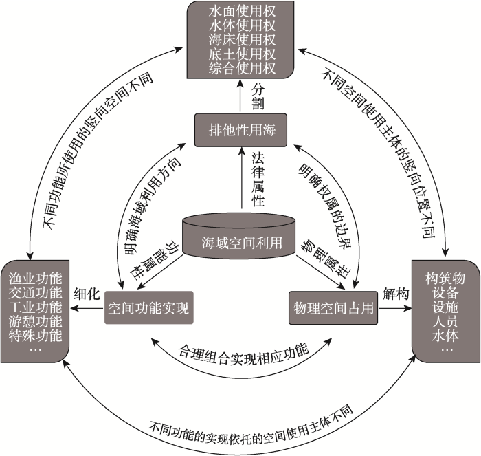
图1
海域空间利用的三种属性及联系
Fig. 1
Three attributes and relations of sea space utilization
表1 典型用海活动的空间使用主体示例
Table 1
| 海洋开发利用活动 | 各实施阶段空间使用主体 | |
|---|---|---|
| 海水养殖 | 筏式养殖 | 设施(浮筏、缆绳、固定设施)、设备(渔船)、人员(养殖工人) |
| 网箱养殖 | 设施(网箱、系泊及附属设施)、设备(渔船)、人员(养殖工人) | |
| 底播养殖 | 设备(渔船)、人员(养殖工人) | |
| 围海养殖 | 构筑物(堤坝)、人员(养殖工人) | |
| 人工鱼礁 | 构筑物(礁体)、设备(施工船) | |
| 港口航运 | 港口 | 设备(船只)、构筑物(引桥、堤坝等设施) |
| 航道 | 设备(船只)、设施(航行标志) | |
| 锚地 | 设备(船只)、设施(锚) | |
| 休闲娱乐 | 浴场 | 人员(游人)、设施(浮标) |
| 游乐场 | 人员(游人)、设备(游艇、帆板等) | |
| 海上风电 | 风机 | 构筑物(风机座墩)、设备(施工船) |
| 海底电缆 | 设施(海底电缆)、设备(施工船) | |
| 跨海大桥桥梁 | 构筑物(桥梁)、设备(施工船) | |
| 核电温排水 | 构筑物(取/排水渠、管道)、水体(温排水) | |
| 海底隧道 | 构筑物(隧道主体、海底附属设施、通风竖井等) | |
由此可见,海域开发利用的排他性,首先是物理意义上的排他性,即因占用特定的物理空间而限制其他物理实体进入;其次是法律意义上的排他性,即海域特定空间已设置海域使用权后,无法重复设置海域使用权。这反映出海域空间使用主体是决定用海活动空间使用特征的关键要素,体现为:(1)空间使用主体的类型、功能、数量等各方面存在显著差异,深刻影响其在海域空间中的位置及变迁。所有空间使用主体运动轨迹的最小包络范围,即用海活动的最小物理空间范围,这是进行竖向空间权属划分的重要依据。(2)用海活动在建设、运营和维护等不同实施阶段的空间使用主体不同,决定了用海活动在不同实施阶段的空间使用特征存在显著差异。以海底电缆用海为例,建设和维护期主要以施工船(设备)发挥关键作用,使用海域的水面、水体和海床三层空间;而在运营期则以海底电缆(设施)发挥关键作用,使用海床空间。(3)海洋开发利用过程中,可能不止一种空间使用主体占用海域空间,用海活动的空间使用特征受多种空间使用主体共同影响。(4)不同空间使用主体的机动性存在显著差异,机动性越强,其占用的空间往往越大,也越难确定范围;反之亦然。
总之,海域立体分层利用的出发点在于竖向空间的合理配置,竖向空间互斥是基本前提,因而用海活动的空间使用特征成为决定海域立体分层利用的关键因素。在用海活动实施过程中,空间使用主体的构成及位置变迁具有相对稳定性和规律性。因此,通过对用海活动的空间使用主体进行解构,挖掘用海活动的时空行为规律,剖析其在不同实施阶段的空间使用特征,进而揭示海域空间立体分层利用中的空间冲突形成机制,有助于海域立体分层利用研究从经验判断向客观评价转变。
2 海域立体分层利用中空间冲突的关键问题探究
2.1 理论与方法
2.1.1 时空行为理论的引入
行为具有生命周期,在不同的时间阶段,行为会带来时空对象几何、属性以及空间关系的变化,进而产生多维复杂影响[20]。时空行为的概念由Hägerstrand[21]提出,是时间地理学的理论基础,指人类活动的行为路径在空间和时间上的表现形式,包括空间分布情况与空间使用频率和密度,常被用作描述人类活动占用环境的时空特征。1969年,Hägerstrand等[22]在会议报告中完整阐述了时间地理学思想与方法,以微观个体的研究视角,将时间与空间结合起来,开拓了个人日常行为分析的方法论基础,也为时空间行为研究提供了理论支撑。进入21世纪,城市空间的合理规划问题得到关注,国内学者开始探索基于时空行为视角的城市规划与治理体系研究。研究内容方面,主要着眼于中国城市居民的时空间行为模式,并拓展至规划应用领域[23],多关注日常生活[24⇓⇓⇓⇓-29]、低碳社会[30]、智慧城市[31]、公共安全[32]等热点问题,探索在城市交通[33,34]、旅游[35⇓-37]和城市规划[38]等公共政策领域中的实践应用[23]。目前,中国时空间行为研究关注城市空间重构的描述与解释,强调国内城市空间与居民个体行为之间的互动关系[23],应用多种研究方法,在时空行为理论框架下,结合个体时空行为大数据,细致刻画居民行为的时空特征,从而为城市规划与公共治理实践提供理论支持,呈现出精细化、动态化的趋势。
时间地理学视角下,行为是时空主体随时间推移而产生的自身状态的变迁,包括空间行为、属性行为、关系行为以及复合行为等四种类型。海洋开发利用过程是一个包含建设、运营、维护等完整周期的连续过程,需要从时间和空间两个维度对用海主体的空间使用特征进行综合考虑。将空间使用主体的行为纳入时空本体进行表达可知,海洋开发利用活动可以视为空间使用主体在组织者操控或外部环境干扰下的状态变化,其时空行为具有复杂性、时态上的延续性等特征,与传统的时空行为研究具有相似性,不过,本文主要研究其空间行为(空间位置变迁)。因此,通过分析海洋开发利用中空间使用主体的空间位置变迁,能够细致刻画其时空特征,从而为海域立体分层利用提供理论和技术支撑。
海洋资源在空间分布上具有整体性特征,海域往往是渔业资源、海水资源、海洋化学资源、空间资源等多种资源的复合空间,但特定用海活动往往只涉及一种资源利用过程,且海洋资源在竖向维度的分布具有相对的稳定性。本文基于当前海域管理实践,将海域竖向空间划分为水面(含上覆空间)、水体、海床和底土。可以发现:渔业资源、海水资源、化学资源一般分布于水体,景观资源、可再生能源一般分布于水面,矿产资源一般分布于底土;空间资源则可按照水面、水体、海床、底土等进一步细分,承载不同用海活动[1]。因而,受资源竖向分布特征影响,在海洋开发利用过程中,空间使用主体在竖向位置上将呈现出相对稳定的规律性,从而可以通过追踪用海活动的空间足迹探寻其竖向空间使用特征。基于此,本文通过分解空间使用主体,逐一分析其在不同阶段的空间足迹,进而明确用海活动在全生命周期的空间范围与位置变化特征,支撑空间冲突分析(图2)。
图2
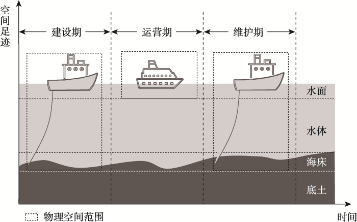
图2
用海活动在不同阶段的位置及物理空间范围——以航道用海为例
Fig. 2
Location and physical space range of ocean uses at different stages: Taking the waterway as an example
2.1.2 研究方法
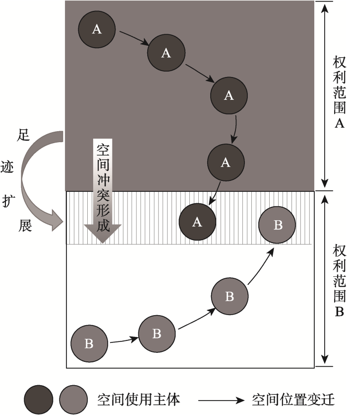
根据《海域使用管理法》,海域使用是指持续使用特定海域3个月以上的排他性用海活动。从法律层面来看,排他性一般指禁止用海活动空间范围的重叠,需要符合“一物一权”的原则。根据前文分析,空间使用主体的位置超出“权利范围”是空间冲突形成的关键环节。从时空行为理论来看,空间位置变化是空间行为的结果。因此,追踪空间使用主体在各个阶段的空间足迹,对用海活动的空间范围进行准确合理的界定,是阐明海域立体分层利用空间冲突形成过程的有效方式。
采用时空行为理论方法确定用海活动的竖向空间范围,首先要获取用海活动在各个阶段的空间足迹。尽管海域开发利用活动是一个连续的实施过程,但研究中很难获取通常意义下空间足迹的统计规律性。因此,本文在传统时空行为研究思路的基础上,借助专家打分法,以建设期、运营期和维护期作为时空对象的时间序列,以空间使用主体所处的竖向空间位置(水面、水体、海床、底土)作为时空对象的空间足迹,分析其时空规律。关键步骤如下:
第一步,明确标准,设计表格。通过技术标准查阅、现场调查、专家座谈等方式,掌握海域开发利用的关键环节和具体步骤,对参与用海活动的空间使用主体进行分解,根据其不同用海时期的空间使用足迹设计打分表(表2)。
表2 空间使用主体空间足迹的打分表
Table 2
竖向 空间 空间使用 主体 | 用海活动1 | 用海活动2 | 用海活动3 | … | |||||||||||||||
|---|---|---|---|---|---|---|---|---|---|---|---|---|---|---|---|---|---|---|---|
| 构 筑 物 | 人员 | 设 备 | 设 施 | … | 构 筑 物 | 人 员 | 设 备 | 设 施 | … | 构 筑 物 | 人 员 | 设 备 | 设 施 | … | |||||
| 水面 | 建设期 | ||||||||||||||||||
| 水体 | |||||||||||||||||||
| 海床 | |||||||||||||||||||
| 底土 | |||||||||||||||||||
| 水面 | 运营期 | ||||||||||||||||||
| 水体 | |||||||||||||||||||
| 海床 | |||||||||||||||||||
| 底土 | |||||||||||||||||||
| 水面 | 维护期 | ||||||||||||||||||
| 水体 | |||||||||||||||||||
| 海床 | |||||||||||||||||||
| 底土 | |||||||||||||||||||
第二步,邀请专家,进行打分。邀请海域管理领域20位专家、技术人员对空间使用主体在竖向空间出现的概率进行打分。打分分值范围为0~9,其中,0~3分代表低概率;3~6分代表中概率;6~9分代表高概率。分值越大,代表空间使用主体在该空间出现的概率越大,反之亦然。
第三步,汇总、整理打分表。专家打分法通过定量分数描述定性问题,最终评价受专家个人主观经验的影响较大。因此,将不同专家对同一指标的打分绘制成箱线图,识别并剔除异常值,再采用切尾均值法进行修正,即去掉最高分和最低分后计算平均值,得到最终结果,将中概率和高概率的空间作为空间使用主体的空间足迹。
2.2 空间冲突的形成机制
在地理学领域,冲突源于人地关系这一核心问题的研究[39],并衍生出土地冲突、土地利用冲突、空间冲突等不同概念[40,41],后来拓展至生态学、规划学、资源科学、环境科学等学科领域。冲突的实质是由于空间的稀缺性、开放性、多宜性等特征,引发了不同利益主体的空间竞争,而产生空间外部性、地理溢出等效应和不协调、不和谐的关系[42]。尽管对冲突的概念与内涵尚无一致观点,但学界普遍认为空间冲突伴随空间利用过程产生,不同利益主体之间存在空间资源配置方式、数量、结构等方面的认同差异,进而产生空间竞争与权益冲突。关于海洋空间利用冲突的研究,学者一般关注不同功能之间的权衡过程[43]与利益相关者协调[44]。与传统的空间冲突研究相比,海域立体分层利用的空间冲突具有微观性,类似于土地利用中的相邻关系,需要从微观尺度和个体视角考虑两种开发利用活动之间的相互作用。然而,相邻关系作为一个法律概念,聚焦权利行使过程中相邻各方的权利义务关系,而海域立体分层利用需更多关注伴随竖向空间资源配置而产生的物理空间互斥与权利空间重叠的问题。
基于前文关于用海活动的时空行为特征分析可以看出,海域立体分层利用中空间冲突的核心不是人地(海)关系的问题,而是在空间资源立体配置过程中,以空间排他性为准则的框架下,不同用海活动空间范围重叠的问题,是为追求空间效率提升而引起的用海活动安全性和可行性的降低。当前海域立体确权制度实践要解决的核心问题,就是现有海域管理制度体系下海域立体分层利用的法律符合性。因此,为确保用海活动的空间权利协调且符合“一物一权”原则,各地海域立体确权制度实践均以明确用海活动的竖向空间范围为基本前提,如海水养殖主要享有水体使用权、海底电缆主要享有海床使用权等。通常情况下,该空间范围既是用海活动所使用的“物理范围”,也是“权益范围”,且“物理范围”决定“权益范围”(图1)。受用海活动实施阶段、技术规范性、海洋环境条件等诸多因素影响,用海活动所使用的“物理范围”并非稳定不变,一旦空间使用主体进入其他用海活动的“权益范围”,即产生空间冲突(图3)。
图3
2.3 空间冲突判别与特征分析
2.3.1 空间冲突判别
选取典型用海活动分析其空间使用主体及其在不同阶段的空间足迹,结果如表3。
表3 典型用海活动不同阶段的空间足迹
Table 3
| 用海活动 | 空间使用主体 | 建设/维护期 | 运营期 | ||
|---|---|---|---|---|---|
| 筏式/网箱/底播养殖 | 设施 | 水体 | 水面、水体 | 水体 | 水面、水体 |
| 设备 | 水面 | 水面 | |||
| 人员 | 水面、水体 | 水面、水体 | |||
| 航道 | 设备 | 水面~海床 | 水面~海床 | 水面 | 水面 |
| 设施 | 水面 | 水面 | |||
| 浴场/游乐场 | 人员 | / | 水面 | 水体、水面 | 水面、水体 |
| 设备 | / | 水面、水体 | |||
| 设施 | 水面 | 水面 | |||
| 跨海桥梁 | 构筑物 | 水面 | 水面 | 水面 | 水面 |
| 设备 | 水面 | / | |||
| 海底隧道 | 构筑物 | 底土 | 底土 | 底土 | 底土 |
| 海底电缆 | 设施 | 海床 | 水面~海床 | 海床 | 海床 |
| 设备 | 水面~海床 | / | |||
| 温排水 | 水体 | / | / | 水体 | 水体 |
表4 海域立体分层利用的空间冲突判别
Table 4
| 立体分层用海模式 | 建设/维护期(B) | 运营期(B) | |
|---|---|---|---|
| 跨海桥梁(A)+温排水(B) | 建设/维护期(A) | / | / |
| 运营期(A) | / | / | |
| 海底隧道(A)+养殖(B) | 建设/维护期(A) | / | / |
| 运营期(A) | / | / | |
| 海底电缆(A)+养殖(B) | 建设/维护期(A) | 空间剥夺 | / |
| 运营期(A) | 空间侵入 | 空间侵入 | |
| 海底电缆(A)+航道(B) | 建设/维护期(A) | 空间剥夺 | / |
| 运营期(A) | 空间限制 | / | |
| 浴场(A)+海底电缆(B) | 建设/维护期(A) | 空间剥夺 | / |
| 运营期(A) | / | 空间侵入 | |
2.3.2 空间冲突的特征
基于表4研究,海域立体分层利用的空间冲突具有以下特征:
(1)空间冲突多形成于用海项目的建设期或维护期。在建设和维护时期,人员、设备等空间使用主体可能频繁穿越垂直方向内的多层空间,进入甚至长期挤占其他用海活动的实施范围,从而引发空间冲突。以跨海大桥与海水养殖立体分层用海为例,桥墩基础施工期间,作业船只、设备等需要频繁穿越水面至底土的竖向空间,必然影响正常的海水养殖活动,且由于其建设周期长、对空间的扰动剧烈,使企业或渔民无法在跨海大桥建设期间开展养殖活动。(2)用海活动在运营期产生空间冲突的概率较小。随着用海活动相关设施安装完毕并逐渐投入运营使用,海域内各用海活动的物理空间范围基本稳定,不同用海活动空间交叉重叠的现象减少,不容易对彼此造成干扰。以跨海大桥与海水养殖立体分层用海为例,在跨海大桥投入运营后,桥梁、桥墩等所有设施位置固定,不发生位移偏移,因而桥梁下方的海域空间基本稳定,不会干扰海水养殖活动,同时海水养殖活动也不会影响跨海大桥的正常使用;再以浴场和海底电缆立体分层用海为例,在浴场正常运营期间,由于公众娱乐活动或设施操作不当,可能损害海底电缆,但这种概率相对较小。
(3)空间冲突主要包括空间侵入、空间剥夺和空间限制三种情形。空间侵入指由于非正常因素(如施工不规范、受恶劣天气或海洋环境影响)导致空间使用主体短暂进入其他用海活动的空间范围,例如在“海底电缆+海水养殖”模式中,海水养殖设施在施工期内有可能短暂侵入海床,威胁海底电缆安全;空间剥夺指长期或较高频率占用了其他用海活动的空间,以牺牲其他用海活动为代价来开展项目建设或维护,这种情形常发生于大型海洋工程建设过程中;空间限制指根据法律法规要求,为维护某种用海活动安全,而对其他用海活动的限制性要求,如海底电缆穿越的区域,其海床及上方对开发利用活动的一些限制性要求,导致其他用海活动无法正常开展。
2.3.3 影响空间冲突的关键要素
时空行为对象、操控者、空间载体是用海活动时空行为构成的关键要素。因此,本文逐一分析其对空间冲突的影响,具体表现为:
(1)时空行为对象——空间使用主体的机动性。海域利用方式具有多宜性,不同利用方式的空间使用主体存在较大差异,如围海养殖的空间使用主体为海堤(构筑物),而筏式养殖的空间使用主体为浮筏(设施)。进一步分析发现,空间使用主体的机动性对空间冲突的形成具有显著影响,空间使用主体的机动性越强,意味着其空间足迹越容易超出用海活动的理论空间范围。一般来说,各类空间使用主体的机动性如下:构筑物<设施<水体<人员<设备。机动性越强,空间使用主体的位移规律性越弱、可控性越差、运动范围越大,用海活动容易进入其他用海活动的权利范围;反之,机动性越弱,空间使用主体越不容易产生空间位移,甚至在整个生命周期不发生位置变化,用海活动很难进入其他用海活动的权利范围。
(2)时空行为操控者——海域开发利用活动的规范性。若开发利用活动严格遵循相关行业的管理要求,则空间使用主体的足迹一般符合理论分析结果(表3),用海活动的空间范围一般不会发生突变而形成空间冲突。
(3)空间载体——不同竖向空间的物理属性差异。由于水面、水体、海床和底土等不同空间的物理属性存在显著差异,海水具有流动性和开放性,而且受潮汐、波浪、海流等水动力条件影响,水面—水体和水体—底土空间的空间边界并不稳定,从而导致位于水面、海水和海床表面的用海活动极易受到环境条件或其他用海活动影响,空间使用主体的稳定性较差;反之,底土内空间使用主体的稳定性强,其空间足迹一般相对稳定(例如海底隧道、海底电缆等不发生位移),产生空间冲突的概率较小。
3 海域立体分层利用的空间冲突协调
基于前文分析可以发现,协调海域立体分层利用的空间冲突应深刻认识用海活动全周期的空间使用特征。首先,考虑到空间冲突一般产生于项目建设期或维护期,因此,加强项目建设或维护期的施工管控是协调冲突的重点和难点;其次,由于空间使用主体的位置变迁是冲突形成的前提,且空间使用主体一般受用海主体(一般情况下即利益相关者)操控,因此,有必要加强对利益相关者的协调;再次,由于空间使用主体的机动性及其所处的空间范围存在显著差异,因此,有必要完善相关技术标准,明确各类用海活动的竖向宗海范围,从而明确各用海主体(利益相关者)的权利和义务,从微观层面规范用海行为;最后,由于空间规划是海洋开发利用活动的基本遵循,故从长期来看,海域立体分层利用应与空间规划衔接,将施工管控、利益相关者协调等以用途管制规则的形式予以明确,从宏观层面规范用海行为。具体如下:
3.1 加强建设和维护期的施工管控
在多数海域立体分层利用模式中,由于用海活动建设期和维护期内涉及的空间使用主体机动性较强,使得该周期内用海活动的空间范围大于运营期,极容易影响其他用海活动,甚至要以牺牲其他用海活动的正常开展为代价。因此,有必要加强用海活动建设和维护期的施工管控。针对空间剥夺类冲突,应合理规划施工船舶或设备的航行轨迹及施工地点,控制施工强度,避免对海床和底土中的其他用海活动造成干扰或损害;若采用桩基础的用海活动,应精准管控打桩施工活动,确保桩基础的位置、深度等符合要求,避免影响海床或底土中的用海活动。针对空间侵入类冲突,加强施工过程监管,精确掌握其他空间使用主体的位置,规划作业方式和流程,避免出现施工安全问题。针对空间限制类冲突,严格执行相关法律和行业标准规范,保护海底电缆管道等涉及军事、国防、民生的基础设施安全,禁止开展水下爆破、打桩、采挖海砂等不合理的用海活动。
3.2 加强利益相关者协调
在海域立体分层利用中,利益相关者的空间权益、用海活动安全、空间效率、项目成本等受到直接影响。因此,加强利益相关者协调是空间冲突管理的必要环节。建议参考《民法典》关于“相邻关系”“地役权”“建设用地使用权”等相关章节的立法理念,充分协调相邻用海主体的权利关系。首先,优先保障原海域使用权人的合法权益,新申请的用海项目应与原海域使用权人充分协商,达成一致意见后,方可进行海域使用权的竖向分割;其次,后建项目应充分论证项目建设、运营和维护阶段对先建项目的不利影响,包括影响的方式、范围、强度、时间及经济效益等,研判作业方式、施工时间等因素对先建项目的影响程度,提出最优的施工方案;再次,可参考地役权设立海域役权,相邻用海主体可签订海域役权合同并进行登记,明确利益补偿方式与矛盾化解机制,海域役权人应严格按照合同约定的利用目的和方法利用供役海域,尽量减少对供役海域权利人相关权利的限制;最后,对于未设定海域使用权的海域,若新申请项目仅使用单层海域空间,也应提前明确其竖向权属范围,禁止多占、超占空间,为后续潜在的分层用海项目预留空间。
3.3 统一用海活动三维宗海界定标准
随着各地海域使用权立体确权文件的实施,海域立体分层利用模式已得到广泛认同,但与之配套的海域管理制度与技术标准体系尚未完善,用海活动竖向宗海范围的界定尤其被忽视。建议管理部门首先明确海域竖向空间的分层方法及空间范围;其次,深入研究用海活动的空间使用特征,有效评估各类用海活动的空间使用范围、空间影响、潜在冲突,并在现行《宗海图编绘技术规范》的基础上,提出三维宗海的界定标准,减少因权利界定不清引发的权属纠纷,维护海域使用权人的合法权益。在此基础上,可逐一明确不同用海活动享有的竖向空间权利范围,为海域立体分层利用提供结构化、模式化的管理方案,与海域使用论证、审批、海域不动产登记等环节充分衔接。
3.4 优化海洋空间规划与用途管制
受政策调整、产业转型、工程技术等因素影响,不同发展阶段的海洋开发利用类型、方式、规模等存在差异。因此,未来海洋空间规划宜综合考虑平面与竖向两个维度、时间与空间两个要素,开展立体海洋空间规划编制。首先,探索面向立体化利用的海域空间开发适宜性评价。可进一步细化国土空间规划“双评价”指标,考虑用海方式、空间使用主体等具体要素,构建面向立体化开发的海域开发适宜性评价指标体系,评价典型用海活动实施的适宜程度。其次,开展典型用海活动空间扩张趋势模拟分析。可综合采用趋势外推法、模糊分析法等,并结合相关行业规划指标,预测典型用海活动在不同发展阶段的空间需求。再次,优化海域立体空间布局。结合当前成熟的海域立体分层利用模式,通过典型用海活动扩张趋势的空间叠置分析,划分不同发展阶段海域立体分层利用的高潜力区域、中潜力区域和低潜力区域,以及“海上风电+X”、滩涂渔光互补等立体分层用海模式的优先发展区域。最后,完善海域立体分层利用区域的空间管控政策。结合海洋空间规划与用途管制要求,研判高潜力区用海活动的规划符合程度,从空间准入、用海监管等视角提出具体的政策建议和管控要求。
4 结论
随着各地实践的广泛推进,海域立体分层利用的重点开始由模式探索转向空间管理。由于大多数海域立体分层利用均来自不同的用海主体,协调空间冲突成为海域立体化管理的核心问题。在此情况下,本文基于时空行为视角,通过“空间主体解构—空间足迹探析”的方式,准确地描绘海域空间利用的三维立体特征,挖掘用海活动的时空行为规律及关键影响要素,为海域立体分层利用的空间冲突及协调管理提供一个结构化、可重复的认识框架。
不过,本文的研究思路与传统的时空行为研究相比,仍存在较大差异:传统的时空行为研究一般以“人”为研究对象,关注群体行为,并基于多源数据挖掘时空对象的规律性;本文时空行为研究以“空间使用主体”为研究对象,关注空间使用主体的个体行为,时空对象的轨迹相对简单,通过专家打分法剖析时空对象的空间位置特征。因此,建议后续可以选择某种具体的海域立体分层利用模式为研究对象,综合采用遥感解译、现场调查、GIS空间分析等方法,加强用海活动在全生命周期空间足迹的追踪与记录,揭示用海活动在平面和竖向空间的时空行为规律,为海域立体分层利用的空间管理提供技术支撑。
参考文献
海域立体分层使用的现实困境与制度完善
The realistic predicament and system perfection of the stereo stratification usage of sea area
近25年来我国海岸线开发强度变化研究
Analysis on the changes of coastline development intensity in China recent 25 years
基于海域空间资源配置的海底电缆管理与保护研究
Research on management and protection of submarine cables based on allocation of marine resources
海域立体分层使用的产权管理路径研究
Research on the property rights management path of three-dimensional layered use of sea areas
Development of multi-use platforms at sea: Barriers to realising Blue Growth
Toward a common understanding of ocean multi use
Assessment of uncertain alternatives for co-located aquaculture and offshore wind farm in Tasmania
Ocean zoning for conservation, fisheries and marine renewable energy: Assessing trade-offs and co-location opportunities
DOI:10.1016/j.jenvman.2015.01.045 URL [本文引用: 1]
Understanding the spatial diversity of social uses, dynamics, and conflicts in marine spatial planning
DOI:S0301-4797(19)30850-3
PMID:31351276
[本文引用: 1]

Marine coastal environments are often socially complex public areas that need equitable spatial planning approaches. Understanding the extent of extractive and non-extractive uses and the social dynamics that may be driving patterns of use is essential if the spatial plan is to support the social resilience of a marine area. In this study, a combination of fuzzy-set multi-criteria GIS modelling and negative tie social network analysis were used to explore social uses and conflicts based on sketch-mapping interviews with five key stakeholder groups (ecotourism, Aboriginal Traditional Owners, commercial and recreational fishing, and water sports) within a Marine Protected Area (MPA). Most of the areas within the MPA were regularly used by the stakeholders, with non-extractive and extractive stakeholders occupying similar spatial extents, with each stakeholder group having a different pattern of use. However, stakeholder groups had different levels of perceived priority to access these areas and support of the current spatial management plan, especially within the ecotourism and Aboriginal Traditional Owner groups. The investigation of social conflicts in shaping patterns of use revealed that most stakeholder conflicts do not necessarily occur in areas of overlaps, but generally in areas of high biodiversity and easy access through marine infrastructure. Ecotourism groups had the most perceived conflicts over marine space, which shaped their use towards certain no-take zones that protected high biodiversity and would also provide protection from other conflicting stakeholder uses (e.g., boating, fishing). Overall, the method outlined in this paper presents a way for marine spatial management to consider not only the extent and diversity of social uses in a marine environment but also the spatial-social dynamics that may determine the success of the spatial plan in supporting long-term social resilience.Copyright © 2019 Elsevier Ltd. All rights reserved.
海域多层次利用中使用权分层确权初探
The research on separating usufruct into layers in sea areas of multilayered use
海域空间三维多层产权研究
Research on sea areas of three-dimensional multilayer property
海域立体确权可行性研究
The feasibility of stereo sea right confirmation
海域空间用途管制的现状、问题与完善建议
The status quo. problems and suggestions for improvement of the control of the use of sea space
海域使用权立体分层确权及管理配套制度探讨
Research on three-dimensional multilayer usufruct of sea areas and associated management system
Toward a 3D marine cadastre in support of good ocean governance: A review of the technical framework requirements
海域分层使用权的性质及相关问题探讨
On the nature of the right to use stratified sea area and related issues
海域资源综合利用视域下的使用权配置研究
Allocation of sea areas utilization rights from the perspective of the comprehensive utilization of marine resources
海域功能分类体系协调性判别方法
DOI:10.31497/zrzyxb.20220402
[本文引用: 1]
海域功能分类是海洋空间规划编制和实施的基础标准,建立不同海域功能分类体系的协调方案是实现海洋空间规划多规合一的必要条件。因此,梳理我国现行海域功能分类体系,选取实施已久的海洋功能区划的功能区分类,以及自然资源部最新推出作为国土空间规划标准的海域利用分类,在明确海域功能分类体系协调性内涵的基础上,从海域用途符合性、环境质量标准符合性、开发利用影响三方面构建不同海域功能分类体系的协调性判别方法,并依此得出海洋功能区分类和海域利用分类的协调性判别矩阵。结果表明:协调类型为“兼容”或“有条件兼容”的海域利用组合共计22对,为国土空间规划中海域混合利用和分层利用的重点关注对象。
Research on the judgment of coordination of marine function classification system
DOI:10.31497/zrzyxb.20220402 URL [本文引用: 1]
国土空间规划视角下海洋空间用途管制的关键问题思考
DOI:10.31497/zrzyxb.20220405
[本文引用: 1]
通过对用途管制的概念比较和内涵延伸分析,明确了海洋空间用途管制的核心内容为规划分区与管制规则。规划分区应具有“区域、边界、用途、使用条件”四个基本属性,并以科学认知海洋的客观属性及演变规律为基础,故基于“双评价”客观认知海洋空间的功能或用途是规划分区的关键。海洋空间用途管制面临的四个基本问题是“如何保护”“如何利用”“如何在保护中利用”“如何在利用中保护”。进而,以“双评价”为基础,构建开发保护二维坐标系,明确海洋空间用途管制的政策取向与内容导向。其中,海洋生态空间管制宜采用“分级+分类”的管制方式,海洋开发利用空间宜采用“分区管理+用海准入”的管制方式。
Insights on key issues of marine space use control from the perspective of territorial space planning
DOI:10.31497/zrzyxb.20220405 URL [本文引用: 1]
时空对象行为分类与形式化表达
DOI:10.3724/SP.J.1047.2017.01195
[本文引用: 1]
基于行为驱动的传统时空数据模型只关注时空对象的空间运动行为,忽略了行为对时空对象属性、关系等的改变,导致行为对时空对象的驱动机制研究不足。时空行为是全空间信息系统表达的重要特征之一,为此,本文从以下几个方面阐述了时空对象的行为。首先,本文阐述3行为的定义及将行为作为时空本体的元组的必要性。其次,研究了时空对象行为的复杂性、可继承性及在时态上的延续性等特征。再次,根据行为的作用对象,将时空对象的行为分为空间行为、属性行为、关系行为及复合行为4类行为,并给出了上述4类行为的定义与形式化表达方式。最后,分析了时空本体中时空行为的驱动机制。通过时空行为分类及其在时空本体中的形式化表达研究,为基于行为驱动的时空对象构模奠定了理论基础。
A study on the classification and formalization of the behavior of spatiotemporal object
What about people in regional science?
张艳, 柴彦威. 区域科学中的人
What about people in regional science
中国时空间行为研究进展
DOI:10.11820/dlkxjz.2013.09.006
[本文引用: 3]
自时间地理学和活动分析法引入中国以来的近20年间,时空间行为研究已经成为中国城市地理学的重要领域。中国时空间行为研究关注城市空间重构的描述与解释,试图从行为角度解释中国城市社会转型,强调转型期中国城市空间与居民个体行为之间的互动关系,重视日常生活、生活质量、社会公正、低碳社会、智慧城市等热点问题,探索在城市交通、旅游和城市规划等领域中的实践应用。中国时空间行为研究已经形成了以解读城市转型为目标、以规划应用为导向的鲜明特点,为理解中国城市制度与空间转型背景下人类行为模式的复杂性和多样性提供了一个全新的视角。但是,中国时空间行为研究依然面临着理论发展滞后、实践应用需要突破等挑战。本文是对时空行为研究近年来发展的综述性文章,从数据采集与分析方法演进、实证研究与规划应用进展等方面回顾了近20年来中国城市时空间行为研究的最新进展,致力于推动不同学科领域之间的交流和时空间行为研究自身的发展。
Progress in space-time behavior research in China
DOI:10.11820/dlkxjz.2013.09.006
[本文引用: 3]
As a unique perspective for understanding the complex relationships between human activities and urban environments in space and time, the space-time behavior approach has become an influential methodology in China's urban geography since 1990s. Aiming at promoting communications and exchanges among urban geographers in different contexts, this article provides a critical review of space-time behavior research in China. Ever since time geography and activity-based model were introduced to China's urban geography, space-time behavior research in China has benefited from the fruitful theoretical and methodological progress made in Western geographical research. On one hand, GPS and mobile phone tracking technologies have been integrated into activity-diary surveys to collect more accurate and real-time activity-travel information. On the other hand, advanced statistical models and geocomputational and 3D geovisualization methods have been adopted in more recent empirical literature in China. Yet, while Chinese urban geographers have made more methodological progress in data collection and analytic tools thanks to the development of GPS and GIS technology, theoretical development still lags behind. However, space-time behavior research in China, with planning-oriented characteristics, offers a unique framework for understanding urban transformation in China. It has become a new perspective for understanding the complexity and diversity of human behavior patterns in the transitional cities in China. In other words, space-time behavior research tries to describe and interpret urban spatial structures and spatial reconstructing in urban China from the perspective of individuals' behaviors. The impacts of danwei-based urban spatial organization and its disappearance, as well as the impacts of suburbanization on individuals' daily activities, have been studied carefully. Especially, this approach emphazes how spatial restructuring impact individuals' daily life experiences, which in turn are related to the issues such as life quality, social equity and environmental sustainability. Urban geographers in China have begun to apply the space-time activity approach to the socio-spatial issues in the cities by focusing on daily-activity experiences of low SES (socioeconomic status) populations. And the development of the low-carbon city movement in China has prompted the application of the space-time behavior approach in understanding the impacts of land use characteristics on travel-related carbon- dioxide emissions through individuals' travel decisions. At the same time, planning practices based on the space-time behavior approach is carried out in urban transportation, tourism, and urban planning. The space-time behavior approach has become a very useful human-oriented approach to land use and transportation planning in China. The article concludes by discussing key theoretical and practical challenges for future development of space-time activity research in China.
深圳市民周末休闲活动的空间结构
The leisure spatial structure of Shenzhen citizens on weekends
基于家庭的城市居民出行需求理论与验证模型
Theories and confirmed model of urban resident's travel demand: Considering intra-household interaction
DOI:10.11821/xb200812002
[本文引用: 1]
<p>From the 1950s to the present, the research perspective of urban resident's travel demand transits from trip-based to activity-based, while the study units divide Traffic Analytical Zone (TAZ) into the individuals and even household. This paper summarizes that there are many problems of trip-based travel demand model in theory and practice. For this, the researches of activity-based and intra-household interaction come into being. Activity-based approach is the theoretical foundation of household-based travel behavior analysis, while its own foundation dated from the seminal work of Chapin (1974) and Hägerstrand (1970). Many literatures have confirmed that activity-based analysis could solve the problems using trip-based models so commendably that its contents extend and deepen from the 1980s to now. Thought most activity-based models still focus on the theories, household-based travel models gradually become the mainstream in transport planning in Western countries. Researches of household-based travel behaviors require to synthetically consider the effect on individual's activity-travel behavior of family attribute, the constraint to individual's behavior from household demand, and the couple constraint between household members. These aspects are briefly reviewed in this article. We discover that trip-based approach is hardly competent for studies of intra-household interaction. By contrast, activity-based approach could employ utility-based model, rule-based model, micro-simulation model and complex multi-variable model, such as structural equation model, to better interpret resident's activity-travel behaviors. Finally, Tianjin's time-use dairy survey data are used to confirm the theories of intra-household activity-based approach and to deeply understand the Tianjin's activity-travel behaviors. We model the socio-demographics as exogenous, and activity duration time and relevant travel time as endogenetic in the context of structural equation model (SEM). The final LIRSEL model fits well. The estimate results confirm that travel is derived of activity participation, and activity-based approach can better solve the problems of trip-based model, such as linking the discrete travels through activities interaction. Moreover, significance of activity-travel interaction between household heads positively exists. In particularly, males dominate the outside work-related activities and females dominate the outside household-related activities, and they jointly participate in non-work activities in Tianjin's households. Furthermore, comparing the total effect and direct effect on household heads' travel time of socio-demographics, which takes both the indirect effect of activities and other household members into consideration, we found the significance is not the same and positively argue that the total effect contains more actual information about activity-travel behavior. In conclusion, theories and confirmed model have proved that activity-based approaches are much better than the trip-based one, especially in terms of the intra-household interaction. In the future research, we should spread this perspective and approach to a better understanding of the behavior and transportation in transiting China.</p>
基于T-GIS的广州市居民日常活动时空关系
DOI:10.11821/xb201012002
[本文引用: 1]
随着人文主义思潮的兴起和居民生活水平的提高,关于生活质量的改善问题日益受到重视,以研究个体活动时空关系为重点的时间地理学研究也得到发展。T-GIS 能较好地反映和记录个体活动动态过程,为时间地理学的研究提供了新的技术手段。近年来在工业化、城市化、信息化、住房与就业市场化等多重因素的共同作用下,中国城市的内部空间结构发生了急剧的演化,城市居民的日常活动也发生变化,居民微观行为和日常活动组织及社会空间的研究正成为解释城市空间重构及其机制的重要研究视角。本研究结合T-GIS 和时间地理学基本理论,以广州市为案例,利用居民出行日志的问卷调查数据,开发基于ArcGIS 的居民行为链时空分析工具,揭示了典型时间断面居民的空间分布特征和居民日常活动社会分异的的时空关系。结果表明,居民出行行为具有很强的时空关联性。城市中心区在一天不同时间都保持较强的吸引力,成为居民日常活动中各类活动的主要空间载体;城市空间的拓展,改变了部分居民特别是居住在外围街区居民的日常生活习惯;居民的日常活动时空关系存在一定的阶层分化,低阶层日常总体上离开居住地活动的时间最长,但日常活动的活动空间最小,人均月交通费用最低,主要活动空间位于城市中心区和部分传统单位生活区周边;高阶层日常总体上离开居住地活动的时间最短,其活动范围却最大,主要活动空间位于新城市中心区及其周边地区,人均月交通费用最高;中阶层的活动空间相对均衡,交通费用适中。这种时空关联性的分析,有助于揭示居民的日常活动与城市内部空间结构的关系,拓展基于日常活动过程的城市社会空间研究及交通需求评估,为城市规划和管理提供可靠的依据。
Spatio-temporal pattern of residents' daily activities based on T-GIS: A case study in Guangzhou. China
单位社区居民日常活动模式比较研究: 以西宁市为例
Comparative study on daily activity patterns of unit community residents: Taking Xining city as an example
中国城市休闲时空行为研究前沿
Prospects for urban leisure studies in China: A Perspective of space-time behavior
廉租住房居民的时空间行为特征: 以福州市橘园洲社区为例
DOI:10.13284/j.cnki.rddl.003501
[本文引用: 1]
基于2020年12月福州市橘园洲社区居民的问卷调查结果与48 h活动日志,结合时间地理学理论,采用GIS 95%标准置信椭圆、点密度与叠置分析方法,从微观个体角度研究保障性住房居民工作日与休息日的工作、购物、休闲3类活动的空间特征及其对附近空间的利用情况,并使用多元线性回归分析其影响因素。结果表明:1)案例社区居民在工作日与休息日的活动空间差异较大,休息日居民内部差异大于工作日。2)从不同活动类型看,工作日活动内部差异性较小,整体呈现通勤距离短、依赖社区周边的特性;购物与休闲活动在工作日依赖社区周边,而在休息日均具有明显的空间拓展,且出行人数呈距离衰减。3)居民工作日活动受通勤距离、年龄与收入的显著影响,休息日活动受收入、家庭结构与文化程度的显著影响。4)与一线城市保障性住房选址在城市边缘集中的趋势不同,福州市仍有足够的空间使保障性住房的选址相对均衡。
Temporal and spatial behavior characteristics of low-rent housing residents: A case study of the Juyuanzhou community in Fuzhou
DOI:10.13284/j.cnki.rddl.003501
[本文引用: 1]
Housing has always been a hot issue in various disciplines. Only when people live in peace can they be happy to work and achieve sustainable economic and social development. In recent years, the construction of a large number of subsidized housing communities has provided material protection for low- and middle-income groups, achieving initial results. However, problems in the construction of supporting facilities and site selection have become increasingly prominent. Therefore, it is important to study the spatial characteristics of the daily activities of the residents of affordable housing to better understand their daily needs and promote the development of affordable housing. Taking a typical community of low-cost housing in Fuzhou City as an example, this study used data from a questionnaire survey and 48 h activity log survey in December 2020, and combined in-depth interview materials from typical samples as the database for this study. Based on the theory of time geography, this study investigated the temporal and spatial behavior characteristics of low-rent housing residents from a microscopic perspective. With the help of GIS visualization techniques, such as 95% standard confidence ellipse, point density analysis, and overlay analysis methods, this study adopted a hybrid analysis method combining qualitative and quantitative analysis to study the spatial characteristics of three types of activities of working, shopping, and leisure of low-rent housing residents on one weekday and one rest day and their use of nearby space from the perspective of micro-individuals, and analyzed their influencing factors using multiple linear regression. The results showed that 1) there is a big difference between the activity space of residents in the case community on weekdays and rest days. The activity space of the sample was more fixed on weekdays, and the working and shopping activities were more dependent on the Juyuanzhou area. On the rest days, the average area of the residents' activity space was four times larger than that on weekdays. Residents needed to use a larger area to meet their shopping and leisure needs, and there were greater internal differences among the samples. 2) Residents had relatively small internal differences in work activities, and their workplaces were mainly distributed in the Juyuanzhou area, with a strong dependence on the Juyuanzhou area. The area of activity space was significantly positively influenced by the residents' income, age and work commute distance. 3) Influenced by residents' travel intentions, there was a big difference between residents' shopping and leisure activities between weekdays and rest days. Workdays relied more on the surroundings of the community, while on the rest days, the internal differences in the resident sample increased. Both shopping and leisure spaces had a significant tendency to expand and decay in distance. Shopping and leisure activities were concentrated within 500 m on weekdays and extended to 5 km on rest days. A comparative analysis with the conclusions of related studies revealed the following significant characteristics of low-rent housing residents in Fuzhou: 1) Short commuting distances to work and dependence on community surroundings. 2) Compared with weekdays, the proportion and space scope of residents' rest days for shopping and leisure activities increased significantly, but the spatial scope of activities was still limited due to the limitation of transportation. Unlike the trend of positioning subsidized housing in first-tier cities, such as Beijing and Shanghai, at the edge of the city, Fuzhou has a large space for inner-city renewal and suburban development, and still has enough space to make the siting of subsidized housing relatively balanced. Finally, in view of the existing problems of the case community, some reference measures are provided for the optimization of low-rent housing from two aspects: planning and construction and community building.
城市居民出行的空气污染暴露测度及其影响机制: 北京市郊区社区的案例分析
Measurement of residents' daily travel air pollution exposure and its mechanism: A case study of suburban communities in Beijing
基于时空间行为的人本导向的智慧城市规划与管理
Towards smarter cities: Human-oriented urban planning and management based on space-time behavior research
“时—空—人”交互视角下的国土空间公共安全规划体系构建
DOI:10.31497/zrzyxb.20210906
[本文引用: 1]
公共安全事件是特定情境下“时—空—人”多要素交互作用时空过程的结果,国土空间公共安全规划和相应的能力建设是应对公共安全事件长期而重要的抓手。在构建公共安全规划中“时—空—人”互动的研究框架基础上,分别对“预防、预警、应急、灾后”四个阶段的相关研究和工作重点进行审视,并在此基础上构建国土空间公共安全规划的内容、技术方法和保障支撑体系。首先,在内容体系方面,与国土空间规划的全国—省—市—县—镇等多层级规划编制体系和全国一盘棋的应急响应机制相适应,开展综合规划与专项规划编制,重点解决面向应对自然灾害、事故灾难、公共卫生事件、社会安全事件等方面的空间、设施、应急等方面的规划和管理问题;在技术方法体系方面,构建和完善公共安全事件的时空要素识别与分析、时空过程模拟与预警分析等方法和技术支撑体系;在保障支撑体系方面,基于时空大数据的新基建建设,构建和完善时空可达的公共安全设施体系和公共安全导向下的社会治理体系。
The framework of public security spatial planning from the perspective of 'Human-Space-Time' interaction
DOI:10.31497/zrzyxb.20210906 URL [本文引用: 1]
居民日常出行时空集聚视角下的城市交通拥堵形成机制研究: 以广州为例
DOI:10.13249/j.cnki.sgs.2012.08.921
[本文引用: 1]
随着大城市的迅速蔓延与扩张,市内交通拥堵日益成为世界大城市在发展过程中面临的重要问题,亦成为众多学科研究的热点话题。运用时间地理学的研究方法,以城市居民日常活动的时空集聚为基本研究视角,选取广州作为案例,探讨城市内部交通拥堵形成的机制。研究结果表明,运动型时空共存是产生交通拥堵的根本原因,而出行路径的时空集聚必然造成运动型时空共存。广州市居民的出行行为由于受到时空约束的作用下,造成出行路径的时空集聚,城市的空间结构和路网结构进一步强化其集聚效应,从而形成出行路径的时空共存,并引发交通拥堵。本文的基本结论是城市居民的日常活动受到时间和空间两种因素的共同约束,当两种约束条件达到一定的程度时将产生时空集聚和运动型时空共存,并最终形成交通拥堵。良好的交通管理手段只能促使交通拥堵的状况趋于好转,本质上难以解决交通拥堵问题。城市空间结构、交通线路、交通管制、交通供需状况在一定程度上通过影响居民日常出行路径的时空共存而加剧或缓解交通拥堵现象。所以,在城市交通供需状况处在一种基本合理的水平下,解决大城市交通拥堵问题的根本出路在于降低居民日常活动的运动型时空共存。
Formation mechanism of traffic congestion in view of spatio-temporal agglomeration of residents' daily activities: A case study of Guangzhou
时空间行为视角下交通与社会排斥研究进展
DOI:10.18306/dlkxjz.2022.01.010
[本文引用: 1]
新型城镇化背景下,建设具有包容性和公平正义的城市,成为社会可持续发展的重要内容。交通相关的社会排斥研究主要包括理论研究、社会空间分析、交通与社会排斥的比较研究等,形成了基于空间和基于人群的2种研究范式。但关于不同地理环境和不同社会群体的交通与社会排斥研究,仍然缺乏对空间与行为互动的内在因果关系的有效论证,迫切需要从地理空间和不同社会群体的时空间行为入手,厘清交通与社会排斥的概念内涵和作用机理。论文梳理了交通与社会排斥的概念内涵、研究范式与测度方法,重点从时空间行为视角阐述了交通维度的社会排斥研究的内在逻辑和实证结果,并结合中国实际,试图构建时空间和行为互动的交通与社会排斥研究框架,为消除交通维度的社会排斥障碍、建构多尺度社会融合路径、建设更为包容和公平正义的城市提供实践基础和理论支持。
Progress of research on transportation and social exclusion from the perspective of spatiotemporal behavior
DOI:10.18306/dlkxjz.2022.01.010
[本文引用: 1]
In the context of China's new-type urbanization, how to build more inclusive and equitable cities has become an important question for sustainable social development. Research on transportation-related social exclusion mainly includes theoretical research, socio-spatial analysis, and comparative research on transportation and social exclusion. Supported by a large number of theoretical and empirical studies, two paradigms have been formed: the research based on "space" and the research based on "classification" of specific social groups. However, there is still a lack of effective demonstration of the internal causal relationships between space and behavior. Therefore, it is urgent to clarify the concept and mechanism of transportation and social exclusion from the perspective of geographic space and spatiotemporal behavior of different social groups. This article reviewed the concepts, research paradigms, and measurement methods of transportation and social exclusion, and elaborated on the internal logic and empirical results of social exclusion research in transportation from the perspective of spatiotemporal behavior and activities. Then, a research framework of transportation and social exclusion based on space-time-behavior interaction was constructed based on China's reality. The article attempted to provide a practical and theoretical support for the elimination of social exclusion in transportation, the construction of multi-scale social integration, and the development of more inclusive, equitable, and just cities.
基于时间地理学的景区旅游者时空行为模式研究: 以北京颐和园为例
A study on temporal-spatial behavior pattern of tourists based on time-geography science: A case study of Summer Palace, Beijing
时间地理学与旅游规划
Time geography and tourism planning
中国高等级旅游景区资源多尺度时空差异及其影响因素
DOI:10.31497/zrzyxb.20221014
[本文引用: 1]
以中国337个地级以上城市内的5A和4A级景区为研究对象,通过构建总体分异指数(GDI)并采用探索性空间数据分析(ESDA)等方法,从省级、城市群、城市等不同空间尺度,对2001—2019年中国高等级旅游景区资源时空演化特征进行综合分析。结果表明:(1)4A级景区主导了中国高等级旅游景区数量与增长率的变化趋势,2015年之后增长速度进入相对平缓状态;(2)时序上,中部和东北地区的各省份高等级旅游景区数量较少,但增长率较高,而西部省份则均相对较高,东部省份则是数量最多但增长率最低,到2017年西部超过东部,数量最多;城市规模与高等级旅游景区数量呈正比,与增长率呈反比;(3)空间上,中国高等级旅游景区分布密集程度逐年升高,呈现出主要依托东部沿海地区与中部地区城市群集聚分布的特征,且空间热点、次热点地区占主导地位,形成了“两点集聚—多极多区—集群集聚”的空间演化格局;(4)GDI指数随着研究尺度的缩小而增大,空间尺度越小,高等级旅游景区资源的差异越大;(5)中国高等级旅游景区空间分布主要受社会、经济、资源等因素相互作用的影响,其中人口规模、旅游经济、人文资源是共同的最为关键的因子。研究结果可为优化中国景区资源空间布局以及旅游业高质量及区域协调发展提供一定参考。
The framework of public security spatial planning from the perspective of 'Human-Space-Time' interaction
DOI:10.31497/zrzyxb.20221014 URL [本文引用: 1]
面向城市规划应用的时间地理学研究
Time geography and its application in urban planning
基于生态系统服务的快速城市化地区空间冲突测度及时空演变特征
Spatial conflict measurement in rapid urbanization areas from the perspective of ecosystem services
中国土地利用冲突研究进展
DOI:10.18306/dlkxjz.2020.02.011
[本文引用: 1]
中国正处于经济转型与社会发展的关键时期,土地利用面临着巨大的压力和挑战,土地利用结构失衡凸显,各类用地矛盾日趋激烈,由此引发的土地利用冲突问题日益受到重视,相关研究成果大量涌现却缺少系统的梳理与总结。论文运用文献资料法厘清国内土地利用冲突研究取得的成效,并通过文献总结和对比分析指出现有研究存在的不足,进而为中国土地利用冲突研究提出了新的方向。首先,在对已有文献中土地利用冲突相关概念辨析的基础上,指出土地利用冲突是土地资源利用过程中,利益相关者围绕土地利用方式与结构所产生的人地之间的空间竞争与权益冲突的现象。其次,从土地利用冲突的理论基础、土地利用冲突的利益相关者、土地利用冲突的识别与强度诊断、土地利用冲突的表现形式及分类、土地利用冲突的演变及其驱动机制、土地利用冲突的和解等6个方面对国内相关研究进行归纳和总结。最后,通过对国内外研究成果的梳理和比较提出了未来中国土地利用冲突研究的主要方向:① 经济社会转型背景下土地利用冲突理论体系的补充与完善;② 全球化背景下土地利用冲突研究的内容拓展与范式革新;③ 乡村振兴战略背景下城乡土地利用冲突的空间正义与效率;④ 参与式GIS技术支持下土地利用冲突的定量与定位治理;⑤ 国土空间规划体系整合下土地利用冲突的协调与权衡;⑥ 多学科融合视角下土地利用冲突的集成分析与成果应用。
Research progress and prospect of land-use conflicts in China
DOI:10.18306/dlkxjz.2020.02.011
[本文引用: 1]
China is in a critical period of economic transformation and social development, which brings great pressure and challenges to land use. Therefore, imbalanced land-use structure and conflicting land utilization become more common, which result in more attention to land-use conflicts and thus increasingly more related studies has appeared, but there is a lack of systematic review and compilation of existing research. This study examined the research related to land-use conflicts in China through literature analysis and comparative analysis, and identified the research trends. First, this article points out that land-use conflict refers to the phenomenon of spatial competition and conflicting interests between people and land caused by the way and structure of land use by stakeholders in the process of land use, which was defined by the comparison and identification among relevant concepts related to land-use conflicts in the existing literature. Second, the Chinese land-use conflict research results were summarized and elaborated from six aspects, including the theoretical basis of land-use conflicts, the stakeholders in land-use conflicts, the identification and intensity diagnosis of land-use conflicts, the forms and classification of land-use conflicts, the evolution of land-use conflicts and its driving mechanisms, and the reconciliation program of land-use conflicts. Finally, through reviewing and comparing Chinese and international research results, this article puts forward the future direction of China's land-use conflict research: 1) Complement and improvement of land-use conflicts theoretical system under the background of economic and social transformation. 2) Content expansion and paradigm innovation of land-use conflict research considering the global scale. 3) Spatial justice and efficiency of land-use conflict resolution in the context of rural revitalization strategy. 4) Quantitative and precision management of land-use conflicts with the support of participatory GIS. 5) Coordination and trade-off of land-use conflict resolution under the integration of national spatial planning systems. 6) Comprehensive analysis and results application of land-use conflicts from the perspective of multidisciplinary integration.
近15年来中国土地利用冲突研究进展与展望
Process of land use conflict research in China during the past fifteen years
空间冲突的演变特征及影响效应: 以长株潭城市群为例
The evolution characteristics and influence effect of spatial conflict: A case study of Changsha-Zhuzhou-Xiangtan Urban Agglomeration
DOI:10.11820/dlkxjz.2012.06.007
[本文引用: 1]
With the accelerating process of industrialization and urbanization, China has entered a period of rapid urbanization, which brought along a series of increasingly serious problems of spatial conflict. And the spatial conflict has gradually affected regional harmonious development, even threatened regional security. It is of important theoretical and practical significance to understand the spatial characteristics in the process of urbanization and organic regulation of spatial conflict, to construct the theoretical framework of spatial conflict and to analyze the concept connotation, formation, evolution rules and influence effects of spatial conflict based on introducing sociology conflict theory into geography. Research results can be conducted as follows. Spatial conflict is a objective geographical phenomena emerging with the competition for spatial resources, which stems from the scarcity of space resources and the spillover of space functions. And according to causes, conflicts can be divided into spatial economic conflict, spatial ecology conflict, spatial social conflict and spatial complex conflict. The spatial conflict intensity shows an inverted "U"-shaped change, and its controllability level is divided into four levels of stable and controllable conflict, basically controllable conflict, basically controllable conflict and seriously controllable conflict. Once the conflict upgrades to the controllable level, it will lead to disorders of spatial development, mismatch of spatial resources, serious environmental pollution, ecosystem imbalance, instability of social development and other problems.
How effective is a marine spatial plan: An evaluation case study in China
DOI:10.1016/j.ecolind.2018.11.028 URL [本文引用: 1]
