

土地是人类主要经济社会活动的空间载体[1],土地利用是一个自然与人文结合紧密的复杂系统[2]。在全球环境变化背景下,土地利用转型是土地利用研究和土地系统科学的重点领域[3]。土地利用转型研究起源于20世纪英国学者开展的森林转型研究[4,5],随后在20世纪90年代首次形成了土地利用转型和土地利用形态的概念,并初步指明土地利用转型是区域土地利用形态在时间上的变化[6]。该研究方向在21世纪初引入国内[7],随后国内外学者围绕土地利用转型的理论假说及证实[7,8]、“社会—生态”反馈和“社会—经济”驱动视角下的转型形成机制[9]、理论内涵拓展及显性和隐性形态[10]、区域土地利用转型理论模式和用地形态格局冲突[1]、城乡建设用地转型与经济社会发展的耦合关系[11]、土地利用转型的研究框架[12]、土地利用转型潜力及其形成机制和评价[13]、土地利用转型的诊断与调控途径[14]、土地利用转型视角下的城乡发展战略研讨[10,15⇓-17]以及对耕地[18]、城市建设用地[19]、乡村宅基地[20]、山区农村用地[21]等开展转型的理论与实证解析。
从新古典经济学视角来看,土地利用变化以及土地系统长期性、趋势性[1]、结构性和非线性[9,22]的转型是一个追求用地效益最大化的过程,这一思路可追溯至19世纪德国农业经济学家杜能(Thünen)[23]的农业土地利用同心圆圈层模式以及后续促生的传统地租理论和竞租曲线思想[24]。从竞租曲线出发,是理解土地利用变化的良好视角,相关地理学者基于此探讨了土地利用的基本竞争模型和土地利用变化的一般均衡模型[24]。受上述研究成果的启发,从土地利用变化深入探索至土地利用转型得到了线索指引。土地利用转型是人类经济社会系统与土地环境系统交互耦合作用的结果,而人类改造、利用土地的行为即以多重效益产出为导向,土地利用追求空间效益最大化的思路同样可以引入对土地利用转型的解析中。
关于土地利用效益,以往学者也开展了一系列研究,涉及探讨土地利用结构优化与用地效益最大化的数学模型设计[25]、基于土地利用多重效益目标规划以确立武汉市的最优土地利用结构[26]、基于精明发展的济南城市扩张与土地利用效益评价[27]、10 km边长网格尺度下的黄河流域土地利用效益评估[28]、对区域各类用地的多重效益构建评价体系[29]、提出“综合社会效益指数”进以衡量城市土地利用的社会效益[30]。也有部分学者针对国内各省会城市[31]、环渤海县域[32]、国内城市群[33,34]、东三省地级市[35]、江苏省县域[36]、福建省县域[37]等区域开展了土地利用多维效益测度与评价,并往往对各类效益加以耦合协调关系的探讨。
综上所述,以往相关研究对土地利用效益的测度多以偏宏观的大范围行政区划尺度呈现(例如以地市、区县为单元),相对缺乏中观、微观区域内的精细栅格尺度的土地利用效益测度或效益空间函数呈现,并较少从土地利用效益时空分异演化视角将其与土地利用转型和国土空间开发进行融汇探讨。本文尝试将土地利用空间效益作为探究土地利用变化与转型机理的切入点,从理论层面解析区域土地利用效益空间函数演变与土地利用转型、土地利用形态“协调—冲突—协调”交替演化模式以及国土空间格局优化的关系,并开展案例实证探讨,以期拓宽土地利用转型研究的视野与思路,并为国土空间治理与优化提供借鉴。
1 土地利用效益空间函数
1.1 土地利用效益空间函数的理论阐释
土地利用效益空间函数是一种虚拟的三维函数(图1),即具有三个变量,通过其中两个变量来共同确定某土地利用观测点的地表位置,第三个变量反映上述点位土地利用的效益量。本文认为土地利用效益空间函数依附于一切土地利用空间而存在,区域内每种具体的土地利用类型都有与之对应的土地利用效益空间函数,区域内任意土地利用观测点都有与之对应的土地利用效益函数值。
图1
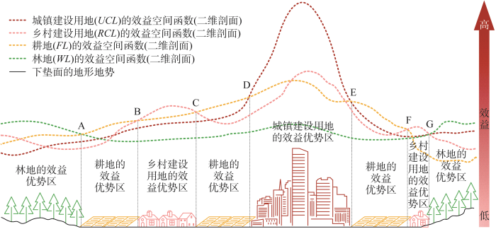
图1
土地利用效益空间函数(二维剖面)
Fig. 1
The spatial functions (two-dimensional profile) of land use benefits
需要强调的是,本文所谓的“土地利用效益”倾向于一种“净收益”,即在一定区域内“维持或造成某种土地利用类型所能为当地社会提供的利益价值量”减去“维持或造成该种土地利用类型所需的成本”。以往学者对土地利用效益的相关界定也多采用上述“产出与投入之比较”的思路[38⇓-40]。土地利用效益是一种综合效益,通常可分为经济效益、社会效益和生态效益等[41]。土地利用的经济效益是指对土地的投入与产出有效产品及服务之间的比较[39];社会效益是指土地利用对社会需求的满足水平和衍生的正向社会影响;生态效益是指土地利用对生态系统结构、过程和功能的影响与改善程度,以及对区域生态平衡维持的贡献[40]。人类对土地进行开发利用的目的在于产出效益,土地利用效益是对应用地类型得以存在的依托,特定地类效益的增加引导该地类的扩张,而效益的衰减往往导致该地类的消亡。
图1刻画了区域城乡地域系统的简单模型,其中既包含了作为实体具象存在的城镇、乡村、耕地、林地及其地表覆被,也包含了作为虚拟抽象存在的上述四种用地类型的效益空间函数。土地利用效益空间函数是虚拟的三维立体曲面,由于三维立体曲面不易描画和文字解析,故本文以其二维剖面作为分析对象。四种用地类型的效益空间函数具有差异化的函数走势、效益值域区间、整体效益水平及其映射于地表的相对优势区。特定社会发展阶段内,土地利用类型的性质主要决定其效益空间函数的效益值域区间及整体效益水平,空间区位及下垫面的差异主要决定效益空间函数的高低起伏和走势波动,各种用地类型的效益空间函数的对比竞争主要决定了各类用地的效益相对优势区。
图1中点D到点E的区间内,城镇建设用地的效益空间函数明显高于其他三种用地类型,故该空间在理论上应当变成城镇建设用地以获取最大的效益。同理,点A到点B、点C到点D、点E到点F这三个区间皆为耕地的效益空间函数相对优势区;点B到点C、点F到点G这两个区间是乡村建设用地的效益相对优势区;点A和点G以外的地区是林地的效益相对优势区。基于各种用地类型的效益相对优势分区,从而实现相应优势地类的稳定存在与持续建设,进而使区域各类用地的总体效益实现最大化,即土地利用空间结构耦合了各种用地类型的效益空间函数的上界面。“自然环境—经济社会—管理体制”[1,24]系统的发展将对各类土地利用效益空间函数进行整体演变,各类用地的效益相对优势区也将随之而变,从而带动土地利用变化乃至更深刻的土地利用转型。
1.2 土地利用效益空间函数的形式表达
一个无面积属性的观测点,只能在理论层面上拥有土地利用效益空间函数值,若要实际测算与表达某地的土地利用效益空间函数值,则需将此地设定为一个有面积属性的观测单元。因此,具体测算与表达土地利用效益空间函数值,需依赖于观测单元的面积,故应当设定好观测单元的空间尺度。在既定的空间尺度下,土地利用效益空间函数的相关表达式为:
式中:LUBijt指区域内第i个观测单元(其归属于第j种土地利用类型)在时间点t时的土地利用效益空间函数值,即因变量。其中i的值域为 [1, n],n为区域内观测单元总个数(个),主要由区域总面积和观测单元的空间尺度决定;j的值域为 [1, m],m为区域土地利用类型的总数(个)。Eijt、Sijt和ECijt分别为第i个观测单元(其归属于第j种土地利用类型)在时间点t时的经济效益量、社会效益量和生态效益量;Ejt、Sjt和ECjt分别为区域第j种土地利用类型在时间点t时的经济效益总量、社会效益总量和生态效益总量(三类效益总量与对应用地类型的面积、地类性质和区域经济社会发展阶段等因素有关);WEijt、WSijt、WECijt分别为第i个观测单元(其归属于第j种土地利用类型)在时间点t时的经济效益的空间权重系数、社会效益的空间权重系数、生态效益的空间权重系数;RLUBt为时间点t时的区域土地利用效益总量,即所有观测单元的土地利用效益空间函数值的总数。
2 土地利用转型的机理
2.1 土地利用转型的动力源及其对土地利用隐性形态的影响
本文认为“自然环境—经济社会—管理体制”[1,24]的三维框架是推动土地利用转型的深层动力源(图2),并塑造了区域各种土地利用类型的隐性形态。自然环境在土地利用隐性形态的塑造中发挥基础支撑和限制作用,社会经济条件是隐性形态的普遍塑造力,管理体制则对隐性形态进行规划调控与快速调整。从用地类型来看,土地利用隐性形态包含了各种用地类型的隐性形态;从形态内涵来看,土地利用隐性形态中涉及的若干维度可以从经济、社会、生态、体制等层面反映特定时期社会大系统的发展状态;从综合用地类型和形态内涵来看,基于各种用地载体并具有丰富属性内涵的各类土地利用隐性形态具有空间异质性。不同的空间区位有其本地化与特殊化的“自然环境—经济社会—管理体制”条件,从而导致土地利用隐性形态在空间上不会均匀地呈现,比如在一些地势平坦、水源与日照充足且靠近聚落或交通路线的地带,便有利于形成较好的耕地质量,从而在产量诱导下增加对耕地的投入,进而往往获得较高的耕地产出能力,甚至引导当地的耕地经营方式发生异于他处的转变,如此一来便形成了土地(耕地)利用隐性形态的空间异质性。
图2
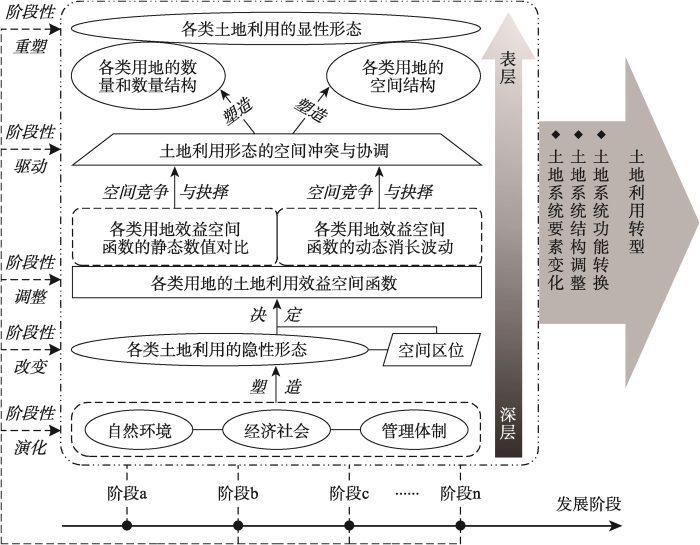
2.2 土地利用隐性形态、土地利用效益空间函数至用地“冲突—协调”的传导路径
空间异质化的土地利用隐性形态是形成土地利用效益空间函数的基础。区域土地利用隐性形态相对优越的地区倾向于实现较大量的土地利用效益产出,因而这些地区的土地利用效益空间函数值较高;隐性形态较恶劣的地区的效益产出往往低微,反映了该地是土地利用效益空间函数的低值区与“塌陷区”。各种具体用地类型的效益空间函数共存于地表空间中,从静态来看,一定空间之上的各类效益空间函数值将进行高低对比与竞争,其中的最高值代表着这片空间在理论上的最大潜在效益产出量,故其对应的用地类型将具有最强的竞争能力,并最有可能将这片空间实现为该类用地;从动态来看,各种用地类型的效益空间函数随时间推进和土地利用隐性形态的变化而演化,由此实现时空分异。例如在特定空间范围内,A类用地的效益空间函数值自上一时间阶段至今居于相对最高位,然而在下一时间阶段它可能不再是最高值,而是被B类用地的效益空间函数值超越,即在理论上B类用地拥有下一时间阶段的最大潜在效益产出量。正因为如此,B类用地具有“以新替旧”的合理性,理论上A类用地应当转化为B类用地,通过这种“新陈代谢”和“以高替低”来促使区域土地系统始终能最大限度地趋近当前时空条件下的最大潜在效益产出。
上述地类间的“新陈代谢”和“以高替低”仅存在于理论层面,在现实中纵使B类用地在下一时间阶段的效益空间函数值超越了A类用地,它也往往难以轻易地将A类用地替换,因为每种土地利用类型是其背后相应利益主体的利益代表,用地类型转换牵涉到相关多元主体的利益格局重构,且需要一定时间的工程手段改造及其他成本投入。因此,旧的、现已存在的A类用地往往具有存在的惯性,而作为效益空间函数值“后起之秀”的B类用地,其背后的利益主体则谋求以B类用地替换A类用地。如此一来,两类用地将爆发严重空间竞争与冲突,经过一段时间的冲突和复杂竞争将决定B类用地对A类用地的替换态势(全部替换、部分替换或无法替换)。现实中区域内参与空间竞争与冲突的用地类型数目可能不止两类,类型数目越多、区域范围越大,空间竞争与冲突便越复杂和激烈,从各方较高强度的冲突转为协调的历时往往越长。
2.3 土地利用显性形态的转变及土地利用转型的实现
土地利用类型及其形态格局的空间冲突将从表层具象层面持续改变各类用地的数量、数量结构及空间结构,进而重塑区域土地利用显性形态。通过一段时间的政策措施调控、多元主体利益妥协和交换以及工程技术运用[3],空间冲突得以大幅消解,空间协调得以逐渐实现,这一方面是对土地利用隐性形态变化和土地利用效益空间函数变化的响应,另一方面意味着对土地利用显性形态完成重塑。综上所述,土地利用形态演变和土地利用转型从深层到表层的作用路径可概括为“三维原始动力—隐性形态变化—效益函数变化—空间冲突协调—显性形态变化”。土地利用转型是一项较长期与复杂的系统过程,需经历从阶段a至阶段n的若干个典型阶段,每个典型阶段都有与之相对应的典型土地利用形态、土地利用效益空间函数典型格局以及经济社会发展典型阶段。在从阶段a至阶段n的土地利用转型过程中,区域土地利用隐性与显性形态得到深刻转变,土地利用空间效益总量得到趋势性改观,土地利用功能得到稳定性更替。
土地利用转型追求区域在当前发展阶段内土地利用隐性形态和“自然环境—经济社会—管理体制”的最佳耦合(隐性形态最优化)以及土地利用显性形态和土地利用效益空间函数的最佳耦合(显性形态最优化),从而将土地利用类型及其形态格局在空间上的强冲突化为弱冲突(协调化),并趋近实现土地利用形态的最大效益总量(效益最优化)。上述过程是一个动态演进过程,在“自然环境—经济社会—管理体制”的较长期变化过程中,土地系统的构成要素不断改变与优化,土地系统结构和土地利用形态不断调整,土地系统功能推陈出新,最终实现新功能的稳定发挥与最大效益总量的趋近。
3 基于土地利用效益空间函数的用地形态“协调—冲突—协调”交替演化模式
3.1 土地利用形态由协调至冲突的阶段
土地是人类与社会发展的基本空间依托,对土地进行开发利用的根本目的在于产出多重效益,即效益趋从性。土地利用效益空间函数是土地开发利用的引导,效益空间函数的时空变化将引发土地利用形态的转变趋势。但由于旧的土地利用形态格局(尤其是显性形态)具有存在的惯性和转变的滞后性,因此当土地利用形态因效益空间函数的显著变化而产生明显转变趋势时,便会与相对滞后、相对顽固的土地利用形态旧格局产生冲突和不协调。冲突和不协调的集中爆发点往往在两种或多种用地类型的效益空间函数的交会处,因为交会处附近的各种用地类型的效益量往往较为接近(因此在旧的用地格局中才能实现多类用地邻近共存的平衡与协调),故当效益空间函数发生显著变化时,函数交会处附近的优势效益地类在理论上很可能会变换,新的优势效益地类在理论上应取代旧的优势效益地类,而旧的优势效益地类则在现实中谋求维持已有的存在。如此一来,旧惯性和新趋势之间的矛盾渐趋激化,区域土地用地形态将从以往的协调格局进入不协调与冲突阶段。
上述冲突的过程是多种土地利用类型所代表的多个利益部门之间的利益冲突与磨合,冲突的动力和目的便在于对全局效益最大总量的追求。如图3所示,在阶段1中,由于各种用地类型的空间格局与其效益空间函数格局实现较佳耦合,各类用地分布在其对应的效益相对优势区,故全局土地利用效益总量趋近于理论上存在的土地利用效益最大总量(理论上存在的效益最大总量由若干效益空间函数的空间格局决定),因此各类用地的空间形态及格局处于相对协调阶段。在该协调阶段,基于现存的土地利用形态和土地利用效益空间函数,便产出相应数量的经济效益、社会效益和生态效益。
图3
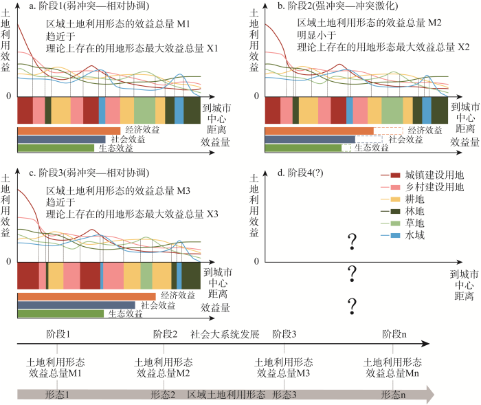
图3
区域土地利用效益空间函数(二维剖面)和用地形态的“协调—冲突—协调”交替演化模式
Fig. 3
The spatial functions (two-dimensional profile) of regional land use benefits and the "coordination-conflict-coordination" alternating evolution mode of land use morphology
至阶段2,由于经济社会发展,物质科技手段、资源需求、土地利用方式以及自然环境和管理体制等发生转变,各种地类的效益空间函数也随之改变。如此一来,效益空间函数之间的交会处、交会地带以及各类用地的效益相对优势区也将发生空间转变。然而现实用地类型的数量结构和空间格局(显性形态)却由于惯性而依然维持在上一阶段的状态,因此导致该阶段土地利用效益空间函数及其衍生的各类用地效益相对优势区与当前土地利用形态之间的不耦合与不协调。在上述的不耦合与不协调背景下,区域土地利用形态的内部冲突激化。与此同时,基于区域用地形态而生成的总效益将明显小于理论上存在的土地利用效益最大总量,经济效益、社会效益和生态效益都与其理想产出量有一定差距。
3.2 土地利用形态由冲突至再协调的阶段
至阶段3,区域土地利用显性形态在阶段2的基础上经过一段时间的调整已经发生转型。各类用地的空间及数量分布与其相应的若干效益空间函数的上界面形成较佳耦合,即各类用地分布在其对应的效益相对优势区。因此,区域土地利用效益总量再一次趋近于理论上存在的土地利用效益最大总量,此时区域土地利用形态由前期的强冲突转化为弱冲突(相对协调)。由于社会发展阶段、土地利用隐性形态以及土地利用效益空间函数的演进优化,阶段3的区域土地利用效益最大总量将大于阶段1的区域土地利用效益最大总量,这一点反映在阶段3的土地利用经济效益、社会效益和生态效益皆高于前两阶段。
基于前三个阶段的模型演绎,区域用地形态从协调到冲突到再协调,这仅仅是交替演化模式的1个典型周期,理论上二者的交替演化没有终点。正是在上述交替演化中,从阶段1到阶段3的区域土地利用效益得到明显优化提升,土地利用形态得到调整和转型,土地系统和社会大系统被推动发展。由上归纳得出,“协调—冲突”交替演化的基本模式不变,但用地效益和社会发展等却得到正向推动,呈现一种螺旋上升式交替演化模式。
3.3 “协调—冲突—协调”交替演化模式的下一个演化周期猜想
基于从阶段1至阶段3的认知,可猜想后续阶段4的土地利用形态、土地利用效益空间函数及其效益产出态势等。在阶段3之后,“自然环境—经济社会—管理体制”经过一段时间的演化,区域土地利用隐性形态的变化将带动土地利用效益空间函数演化,进而导致各类用地效益相对优势区的格局重构。如此一来,现实的土地利用格局相较于率先演变的土地利用效益空间函数将表现出滞后性,土地利用形态内部的结构矛盾将被再次激化,区域土地利用很可能再次进入强冲突阶段。经过这段冲突期的各类用地及其背后利益部门间的博弈和寻求平衡,最终区域土地利用形态格局将再度重构,并追求与土地利用效益空间函数及其衍生的各类用地效益相对优势区尽量耦合。基于最终的耦合结果与重构后的土地利用形态格局,区域用地的经济、社会和生态效益得到更新。值得一提的是,该阶段生成的各类效益和综合效益未必大于前期的效益产出,土地利用效益空间函数和土地利用形态的演变未必随时间推进而一直保持正向优化,“自然环境—经济社会—管理体制”的演化模式和土地利用模式往往并不能始终保持正确性,因此区域土地利用的效益产出有可能出现阶段性衰退。可以将区域土地利用效益的阶段性增减态势作为研判土地利用转型方向的依据:若在一个及以上土地利用“协调—冲突—协调”的演化周期内,区域用地总效益从期初到期末为明显衰减态势,则认为发生土地利用恶性转型;反之,若区域用地总效益为明显增加态势,则认为发生土地利用良性转型,良性转型是应当追求的土地利用转型目标。
3.4 区域土地利用形态与经济社会发展阶段的挂钩
在区域土地利用形态“协调—冲突—协调”交替演化进程中,一定的土地利用形态与特定经济社会发展阶段相对应和挂钩[6,10],基于土地利用效益空间函数的区域土地利用综合效益产出在二者之间发挥纽带与桥梁的链接作用。土地是最基本的自然资源和生产资料,经济社会发展的大部分需求归根结底由土地来满足。在社会大系统发展的不同典型阶段具有不同的典型需求待以满足,例如在传统农业社会,粮食生产与供应是社会发展的典型需求之一,而在工业与信息化社会,工业产品的生产、供应以及信息的高速广泛传播是社会发展的典型需求之一。不同的土地利用形态使土地系统拥有不同的结构和功能,相应地产出不同数量的各种效益及效益总量,进以满足社会发展的不同需求。由上可知,在区域范围内,特定的社会发展阶段需要特定的土地利用形态来满足其发展需求,能在特定发展阶段中普遍且稳固存在的土地利用形态是区域社会的选择,说明该种用地形态的效益产出与当前社会发展需求相协调适配。经济社会发展转型过程中,生产方式和发展需求也在转型,由此投射于空间之上,要求土地利用形态及其空间效益产出也要作出相应转型,故称“土地利用形态的综合效益产出是特定土地利用形态与特定经济社会发展阶段相对应、挂钩的纽带与桥梁”。
综上所述,“自然环境—经济社会—管理体制”演化背景下,土地利用效益空间函数的变化是土地利用形态“协调—冲突—协调”交替演化的上游和驱使环节;土地利用的最终效益产出是“协调—冲突—协调”交替演化的下游响应;土地利用转型是土地利用形态“协调—冲突—协调”交替演化的长期性结果;社会大系统发展是用地形态“协调—冲突—协调”交替演化的背景、舞台和最终目标;区域土地利用形态的效益产出量是特定土地利用形态与特定经济社会发展阶段相对应、挂钩的纽带与桥梁。
4 土地利用转型对国土空间格局优化的作用
4.1 “双评价”对国土空间规划的作用及与土地利用转型的关系
党的“二十大”报告指出:“深入实施区域协调发展战略、区域重大战略、主体功能区战略、新型城镇化战略,优化重大生产力布局,构建优势互补、高质量发展的区域经济布局和国土空间体系……健全主体功能区制度,优化国土空间发展格局,”上述中央精神指示了国土空间格局优化治理的战略需求。国土空间格局是基于人的发展目标下的地域空间的结构与布局[42,43],国土空间规划的编制与实施是国土空间格局优化的必由之路。“双评价”(资源环境承载能力评价和国土空间开发适宜性评价)是国土空间规划编制的基础和前提[44⇓-46],也是当前中国开展较大范围国土空间格局优化、实现较大范围土地利用转型的必要前提。区域当前现实的用地格局和用地模式与最新的国土空间规划之间往往存在一定差异,落实国土空间规划将弥合这种差异,要求转变当前国土空间格局,区域土地利用转型即产生于此。由此可知,存在“双评价—国土空间规划—土地利用转型”的逻辑链。
生态保护、农业生产、城镇建设是国土空间开发适宜性评价的主要功能维度,“三区”(农业空间、生态空间、城镇空间)、“三线”(生态保护红线、永久基本农田保护红线和城镇开发边界)的划分也是沿袭这个功能分类。上述功能空间的“三分法”以及“双评价”能清晰地抓住区域发展的核心需求,然而对于精细尺度的小区域(区县以下,尤其是村镇区域),更丰富细致的土地利用需求和土地利用规划以及凸显出复杂性的经济社会关系网络使得“双评价”的作用受限,国土空间开发适宜性评价的地域功能“三分法”略显粗糙,不利于适应微观层面的精细用地格局优化调控。
4.2 土地利用效益空间函数测算及效益优势分区的补充性作用
作为地理演化过程的土地利用转型具有明显的尺度差异性。空间尺度和考察区域范围越大,使得土地利用效益空间函数的演变越缓慢,土地利用转型的条件越苛刻,转型难度也越大,转型进程越漫长;空间尺度与区域范围越小,土地利用效益空间函数的演变越快速,土地利用转型难度越小,转型速度越快。此外,土地利用效益空间函数演变与土地利用隐性形态的丰富内涵相连接,可以在较小尺度与微观层面上及时捕捉到经济社会多维变化的表征,进而为精细地类的土地利用转型调控和用地空间格局优化提供依据。因此,从转型效应的显著性和空间优化的精细性来看,由土地利用效益空间函数演变驱动的用地形态转换和土地利用转型在较小区域与精细尺度上对国土空间格局优化具有服务优势,有助于对丰富的地类和地域功能进行空间规划,对“双评价”发挥补充性作用。
综合分析区域“自然环境—经济社会—管理体制”是资源环境承载能力评价、国土空间开发适宜性评价、土地利用效益空间函数测算及效益优势分区的共同基础(图4),三者在各自的优势范畴与国土空间规划和格局优化相衔接。同样的国土空间,在不同的功能导向下具有不同的资源环境承载力与开发适宜性[44],实施不同强度的土地生态保护和土地潜能开发。但无论何种主导功能导向,区域土地利用(国土空间开发)评价与规划都要在接受刚性“三线”限制的基础上追求“经济—社会—生态”效益的最优化[47],追求空间开发格局与各类土地利用效益优势区的耦合,其中“三线”的刚性规划实际上也是对“经济—社会—生态”效益的特殊调控。因此可以在大中区域内(如区县及以上)开展“双评价”,构建区域国土空间规划与主体功能定位的总体结构[48],运用底线思维与因地制宜的发展思维实施土地生态保护与土地潜能开发。然后在较小区域与尺度内(如村镇区域)及时追踪土地利用隐性形态变化和土地利用效益空间函数及其格局的演化,通过多类用地效益有序竞争而取优的思路,因时、因地、因法制定好土地利用规划与开发模式[49]。在规划过程中,必然涉及解构土地利用旧格局和处理土地利用的竞争与冲突关系[50],因此要在土地利用“冲突—协调”中依法确立不同利益主体的利益划分、协调与补偿机制[51],改革创新自然资源产权制度[52],引导土地利用良性转型。
图4
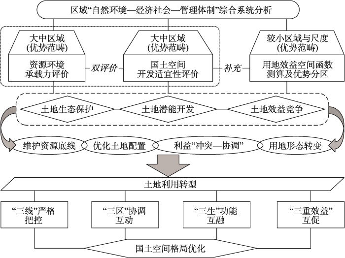
图4
土地利用转型对国土空间格局优化的作用
Fig. 4
The role of land use transitions on the optimization of territorial spatial development patterns
4.3 土地利用转型的推进及其国土空间格局优化效应
基于上述贯穿各种区域规模的土地生态保护、土地潜能开发、土地效益竞争以及配套的利益冲突协调机制,区域国土空间的资源承载力底线得到维护,土地资源配置得到优化,因地制宜的开发思路得以贯彻,同时在中小尺度上不同利益部门和发展主体间的利益关系在用地格局变迁中由冲突转为协调,土地利用显性形态也根据隐性形态变化的内生要求而变化,最终推动区域土地利用的顺利转型。上述土地利用转型并不是自身独立完成的,而是与更大尺度的国土空间规划交互衔接进而协同完成的,因此也是作为后者的延伸与补充而存在的。
上述土地利用转型过程中,“三线”得到首要的严格把控,土地系统结构转型所带来的结构效应[3]将优化“三区”的功能并提升“三区”互动的能力,推动三者协调发展。在土地利用转型及其调控下,“三生”(生产、生活、生态)空间与“三生”功能不应当呈现简单几何图形式的聚集独立,而应该在形成各自主体区的基础上又在多尺度中交融、复合与互嵌,遵循一种“分形结构”[53],以实现空间开发利用的多功能化、高效化与高质量化。最后在土地利用形态“协调—冲突—协调”交替演化模式中,区域各类用地空间与其对应的效益空间函数的较优耦合格局得以调试形成,促使“经济—社会—生态”效益的相对充分产出。三重效益的同步提升有助于在三者之间构建互促循环体系,使三重效益实现互相转化,长远来看,有助于区域人地关系地域系统和城乡地域系统内的多类效益持续再生。综上,土地利用转型对“三线”“三区”“三生”和“三重效益”均有正向作用,由此推动区域国土空间格局的优化。
4.4 土地利用转型优化国土空间格局的实践案例解析
由土地利用效益空间函数演变驱动的用地形态转换和土地利用转型在较小区域与精细尺度上对国土空间格局优化具有服务优势,而土地整治是土地利用转型的重要实践抓手,故选择村域土地整治案例来实证探讨土地利用转型对国土空间格局的优化作用。
东衡村位于浙江省德清县洛舍镇,2020年总人口3109人,面积10.4 km2,其所在的德清县是中国乡村土地整治的试点县[54]。东衡村初以采矿业为主,故留下了大量矿坑,既破坏了当地的生态环境,又造成土地的低效闲置和用地功能的供需失衡。2009年,东衡村根据国家用地政策和乡村内生需求的生态转向,开始重点改善当地生态环境。该村借助工矿用地整治项目,关闭了村内矿业企业,通过生态恢复和废弃矿坑回填对矿山开展修复;通过宅基地整治项目,推动分散的、用地效率低下的农村居民点向集约型、设施完备型现代居民点转变[54]。为了弥补工矿企业关闭所造成的经济损失,东衡村以股权投资的方式将村内农用地的经营权流转给村集体,随后借助土地整治和“城乡建设用地增减挂钩”的用地政策,使农用地和建设用地都得到集中整治,为后续规模生产奠定基础。通过乡村集体建设用地整治和废弃矿坑回填,东衡村将闲置用地盘活,并把新增土地用于建设“钢琴产业园”,继而招商引资、带动就业,将产业的经济产出用于村集体建设、村民分红和环境改善等,乡村发展路径得到彻底扭转。
联系图2的机理阐释,东衡村土地整治的背景是区域“自然环境—经济社会—管理体制”变化,在此背景下该村用地隐性形态[55]和土地利用效益空间函数发生转变,带来土地利用形态的冲突加剧。随后该村通过土地整治的手段来改造用地方式,调试用地格局,缓解用地冲突。在土地整治和后续建设过程中,东衡村土地利用隐性形态和土地利用效益空间函数得到了进一步的、能动性的提升。至2020年,东衡村土地利用的隐性与显性形态明显优化,用地形态从之前的冲突转为再协调,村内用地综合效益大幅提升,土地系统的新功能稳定发挥,土地利用转型得到阶段性实现。在土地利用转型进程中,东横村改造和淘汰了低效益的用地类型,在留足生态用地的基础上,又腾出空间用以引入和建设高效益的用地类型,推动多元化的地类格局与效益优势区之间的耦合。基于此,该村的土地生态保护、潜能开发和效益取优得到落实,进而维护了土地资源承载力底线,优化用地配置,并通过一系列利益联结和价值联结制度来拓展与协调多元发展主体的利益,保障该村用地新模式的长久运行。在东衡村土地利用转型和乡村发展转型之下,形成了“三生”功能兼顾、多重效益互促的用地形态,反映了该区域国土空间格局的优化重构。
5 结论与讨论
5.1 结论
本文从土地利用效益空间函数视角探讨土地利用、土地利用转型机理、土地利用形态的“协调—冲突—协调”交替演化模式以及用地转型对国土空间格局优化的作用等,结论如下:
(1)土地利用效益空间函数是一种虚拟的、具有时空变异性的三维函数,依附于区域内的一切用地类型而存在,反映区域各类用地的效益产出格局。区域内各类用地的效益空间函数共同决定了每种地类的效益相对优势区。
(2)区域土地利用转型从深层到表层的机理路径可概括为“三维原始动力—隐性形态变化—效益函数变化—空间冲突协调—显性形态变化”。土地利用转型追求区域用地隐性形态和“自然环境—经济社会—管理体制”的最佳耦合(隐性形态最优化)以及土地利用显性形态和土地利用效益空间函数的最佳耦合(显性形态最优化),从而将各用地类型及其形态格局在空间上的强冲突化为弱冲突(协调化),并趋近实现土地利用形态的最大效益总量(效益最优化)。
(3)在“自然环境—经济社会—管理体制”演化背景下,土地利用效益空间函数的变化是土地利用形态“协调—冲突—协调”交替演化的上游和驱使环节,土地利用的最终效益产出是其下游响应,土地利用转型是上述交替演化的长期结果,社会大系统发展则是用地形态“协调—冲突—协调”交替演化的背景、舞台和最终目标;区域土地利用形态的效益产出量是特定土地利用形态与特定经济社会发展阶段相对应、挂钩的纽带和桥梁。
(4)土地利用转型在较小的区域与尺度上对国土空间格局优化具有服务优势,且需与更大尺度的国土空间规划交互衔接进而协同实现优化效应。
5.2 讨论
社会发展是资源需求的提出方,土地利用是资源的供给端与需求的满足方,空间效益产出是土地利用满足社会发展需求的手段与方式,也是土地利用的永恒价值追求。区域多元化的土地利用类型及其动态的、有形或无形的结构是对社会多元发展需求的空间响应,因此形成了与不同社会发展阶段相对应的各种土地利用形态,反映土地系统的“要素—结构—功能”始终追求与社会发展相协调适配,并体现了“自然—社会”系统、“人—地”系统的有机统一和耦合互动。
对于土地利用转型的机理机制,以往学者基于各种视角已有不少见解。人地关系地域系统理论是解释土地利用转型的理论依托,土地系统结构变化引发的结构效应[3]和功能转换是用地转型的主要过程。有学者也认为土地利用转型的机制表现为人口、经济、技术、制度、区位、文化等深层驱动因素沿作用路径的级联驱动效应,实质上是社会—经济系统、社会—生态系统和社会—体制系统之间的互动[12]。政策性因素可以通过控制各类用地供给,构建政策引导下的社会—生态反馈路径,又通过调控产业结构、收益产出和人口特征等来影响区域用地需求,形成社会—经济变化诱发路径。两种路径耦合互动,共同驱动土地利用转型[56]。对于广大山区农村,土地利用转型是由外部工业化、城镇化和山区社会—生态系统要素变化共同驱动的,其中社会经济因素起主导作用。务农机会成本上升、恶劣的生存环境等引发了劳动力转移,缓解了人地矛盾,带来土地利用转型[21]。上述观点从不同侧重面揭示了土地利用转型的机理,为本文的展开提供借鉴,且有进一步提炼与综合各方研究成果的必要。
土地利用的空间效益产出是人地之间形成整体关系的重要衔接环节,为寻求贯穿于“生产方式转型—社会需求转型—人地关系转型—土地利用转型”大系统、长过程的主干线索提供了思路。本文选择从土地利用效益空间函数视角切入,尝试探索新路径以理顺土地利用转型的机理,剖析区域用地形态“协调—冲突—协调”交替演化模式和国土空间格局优化效应。本文主要对土地利用效益空间函数和土地利用转型开展定性论述,未来如何对各类用地的效益空间函数进行实际测算?不同用地类型效益产出的量纲和换算方法如何统一?如何挖掘土地利用效益空间函数变化的驱动因子及其作用机制?如何广泛开展效益空间函数变化驱动下的土地利用转型实证检验和国土空间格局优化实践?这些问题值得进一步深入探讨。
参考文献
论土地利用转型与土地资源管理
DOI:10.11821/dlyj201509001
[本文引用: 6]

自21世纪初土地利用转型这一研究方向引入中国后,土地利用转型已成为当今学术界和国家行政部门十分关注的重要课题。在拓展深化土地利用转型的概念内涵,阐述土地利用转型的理论模式基础上,探讨了土地利用转型与土地资源管理二者之间的互馈机制,进而分析了土地利用转型与土地资源管理二者之间的相互影响。研究指出:决策部门应根据土地利用形态的变化适时调整土地资源管理政策措施,充分考虑目标区域所处的土地利用转型阶段,以增强土地资源管理决策的科学性。在探讨未来土地利用转型与土地资源管理研究方向基础上,强调土地利用隐性形态及其变化应当成为今后土地利用转型与土地资源管理研究关注的焦点,通过管控土地利用隐性形态的变化来创新土地资源管理政策法规及制度,提升土地资源管理水平。
Land use transition and land management
DOI:10.11821/dlyj201509001
[本文引用: 6]
With the introduction of land use transition to the academic circle of China since the turn of the new millennium, related researches combining with the characteristics of China's socio-economic development have been carried out extensively. Recently, issues related to land use transition in China have attracted interest among a wide variety of researchers as well as the government officials. Land use transition refers to the changes in land use morphology including dominant morphology and recessive morphology of a certain region over a certain period of time driven by socio-economic change and innovation. In general, dominant land use morphology refers to the quantity, structure and spatial pattern of land use, and recessive land use morphology includes land use features in terms of aspects of quality, price, property rights, management mode, input and productive ability, and function. This paper puts forward the theoretical model of regional land use transition as the following: with the socio-economic development, the transformations between different land use types during a certain period of time arise the changes of regional land use morphology pattern from strong conflict to weak conflict, i.e., coordination, which enable a new balance between different land use morphology patterns reflecting the development trend of different economic departments, and then realize the transformation of urban-rural land use system from quantitative change to qualitative change. Then, the mechanism of mutual feedback between land use transition and land management was probed based on a three-fold framework of natural system-economic system-managerial institution system. Generally, land use transition is affected by land management via economic measures, land resources engineering, policy and institution. Land use transition can also contribute to the adjustment of land management measures via socio-ecological feedback. Therefore, policy-makers need to adjust their land management policies taking into account the continuous change of land use morphology and different phases of regional land use transition. Under the background of urban-rural transformation development, the researches of land use transition and land management may focus on how to measure the transitions of land use dominant morphology and recessive morphology and the subsequent transition of the function of land use system, how to measure the socio-economic and environmental effects of land use transitions, how to refine the popular model of regional land use transition, and how to adjust land use transition via socio-economic and engineering measurements. Finally, the author argues that more attentions need to be paid to the recessive morphology of land use, the change of which is the key to policy and institution innovation and improving land management.
现代人地关系与人地系统科学
DOI:10.13249/j.cnki.sgs.2020.08.001
[本文引用: 1]
人地关系地域系统理论系统提出30 a来,对促进地理学综合研究、学科建设和服务国家重大战略决策发挥了重要的科学支撑与导向作用。深入解析了人地关系地域系统理论的科学内涵及时代价值,诠释了现代人地系统的类型与环境,提出了“人地圈”与人地系统科学研究的主要内容和前沿领域。初步研究表明:① 现代人地系统具有复杂性、地域性和动态性特征,人?地交互作用过程、格局及其综合效应正在发生深刻变化,地球表层人地系统成为现代地学综合研究的核心内容和重要主题。② 科学认知和有效协调人地关系,亟需深入探究人地系统耦合格局与机理,探明人地关系地域系统类型、结构及其动力机制。依据城乡关系将人地关系地域类型划分为城市地域系统、城乡融合系统、乡村地域系统。乡村地域系统可细分为农业系统、村庄系统、乡域系统、城镇系统等子系统,分别对应于作土关系、人居关系、居业关系、产城关系。③ 现代人类活动强烈地作用于地球表层人地系统,形成了人地系统耦合与交互作用的地表圈层——“人地圈”,其实质是现代人类活动与地表环境相互联系、耦合渗透而形成的自然–经济–技术综合体或人地协同体。④ 人地系统科学或人地科学是研究人地系统耦合机理、演变过程及其复杂交互效应的新型交叉学科。它是现代地理科学与地球系统科学的深度交叉和聚焦,以现代人地圈系统为对象,致力于探究人类活动改造和影响地表环境系统的状态,以及人地系统交互作用与耦合规律、人地协同体形成机理与演化过程。人地系统耦合与可持续发展是人地系统科学的研究核心。传承创新人地关系地域系统理论和发展人地系统科学,更能凸显地球表层人类的主体性、人地协同的过程性和可持续发展的战略性,为人地系统协调与可持续发展决策提供科学指导。
Modern human-earth relationship and human-earth system science
DOI:10.13249/j.cnki.sgs.2020.08.001
[本文引用: 1]
In the past 30 years, the theory of human-earth areal system has played an important support and guidance role in promoting the comprehensive research, disciplinary development and serving national strategic decision of geography. This study analyzes the scientific connotation and era value of human-earth areal system, explores the types and environment of modern human-earth system, and puts forward 'human-earth sphere' and the main contents and frontier fields of human-earth system science. The results show that: 1) The modern human-earth system is characterized by complexity, regionalism and dynamicity. The processes, pattern and comprehensive effect of human-earth interaction are undergoing profound changes, and the human-earth system on the surface of the earth has become the critical content and important theme of modern geosciences. 2) To scientifically understand and effectively coordinate the human-earth relationship, it is urgent to explore the coupling pattern and mechanism of human-earth relationship and to analyze the type, structure and dynamic mechanism of human-earth areal system. Based on the urban-rural relationship, the human-earth areal system can be divided into urban regional system, urban-rural integration system and rural regional system. Furthermore, the rural regional system is subdivided into agricultural system, village system, rural system and township system. 3) Modern human activities strongly affect the human-earth system on the surface of the earth, forming a new surface with the coupling and interaction between human and earth. In essence, it is a natural-economic-technological synthesis or human-earth coordination. They are also the main contents of deepening the researches on the coupling of human-earth system and supporting decision-making for coordinated development of human-earth system. 4) Human-earth system science or human-earth science is a new interdisciplinary subject which studies the coupling mechanism, evolution process and complex interaction effect of man earth system. It is the deep intersection and focus of modern geographic science and earth system science. Taking the modern human-earth sphere system as the research object, it is committed to exploring the state of human activities transforming and affecting the surface environment system, the interaction and coupling law of human-earth system, the formation mechanism and evolution process of human-earth coordination.Human-earth system coupling and sustainable development is the core of human-earth system science. Inheriting and innovating the theory of human-earth areal system and developing the human-earth system science will highlight the subjectivity of human on the earth surface, the process of human-earth coordination and the strategy of sustainable development, thus providing scientific guidance for the coordination of human-earth system and sustainable development decision-making.
土地利用转型的解释
Explanation of land use transitions
National land use morphology: Patterns and possibilities
区域土地利用转型分析: 以长江沿线样带为例
Analysis on regional land use transition: A case study in transect of the Yangtze River
中国农村宅基地转型的理论与证实
Rural housing land transition in China: Theory and verification
DOI:10.11821/xb200610009
[本文引用: 1]
This paper develops a theoretical framework for rural housing land transition in China. Land use transition refers to the changes in land-use morphology over time, and it usually corresponds to a particular socio-economic development phase. Land use transition is also one of the major research contents of Global Land Project (GLP), a joint research agenda of the International Geosphere-Biosphere Programme (IGBP) and the International Human Dimensions Programme on Global Environmental Change (IHDP) to improve the understanding of land system dynamics. Although our understanding of land-use and land-cover change (LUCC) has improved through carrying out a lot of studies on land system, it seems that LUCC research still remains under-theorized. Research on land use transition needs new methods to incorporate the historical aspects and timescales of social and environmental changes. The discipline which in principle should be most able to meet the demands is geography. There is tremendous scope for this kind of study, which needs the knowledge concerning physical geography as well as human geography. By understanding the change process of rural housing in China, theoretical hypothesis on rural housing land transition was put forward. It is assumed that rural housing in China will undergo specific stages-the proportion of rural housing in the increase of total construction land will decline gradually with the development of the local economy, and the end of the transition corresponds to a kind of equilibrium between rural housing and other construction activities. Henceforth, the research results of rural housing land transition in the transect of the Yangtze River were used to verify the above hypothesis.
Land use transitions: Socio-ecological feedback versus socio-economic change
DOI:10.1016/j.landusepol.2009.09.003 URL [本文引用: 2]
论土地利用转型与乡村转型发展
DOI:10.11820/dlkxjz.2012.02.001
[本文引用: 4]
土地利用转型这一研究方向引入中国后,结合中国社会经济特点的相关研究篷勃开展。土地利用形态是土地利用转型研究的核心内容,在社会经济变化和革新的影响下,随着研究的不断深入,土地利用形态的概念内涵被不断拓展。本文在分析土地利用形态概念内涵的发展演变基础上,提出将其分为显性形态与隐性形态两种形式,并以此诠释了土地利用转型的概念模式,进而探讨了土地利用转型与乡村转型发展之间的关系。研究指出:耕地和农村宅基地这两种地类乃乡村发展与土地利用转型之重要源头。随后探讨了乡村转型发展与耕地和农村宅基地利用转型之间的相互作用关系。最后提出未来土地利用转型与乡村转型发展的研究方向,涉及土地利用转型与乡村转型发展的格局与地域类型、互馈作用机理与动力机制、资源与环境效应、优化调控模式和途径等方面。
Land use transition and rural transformation development
DOI:10.11820/dlkxjz.2012.02.001
[本文引用: 4]
Recently, related researches on land use transition combining with the characteristics of China’s socio- economic development have been carried out rapidly since the research field of land use transition was introduced to China. Land use morphology is the key content of land use transition research. However, the concept and connotation of land use morphology has been developed continuously with the in-depth research and socio- economic change and innovation. Based on the analysis of the evolvement of the concept and connotation of land use morphology, this paper argues that there are two formats for depicting land use morphology: one is dominant morphology, and the other is recessive morphology. The dominant land use morphology refers to the quantity, structure and spatial pattern of land use, and the recessive land use morphology includes the land-use features in the aspects such as quality, property rights, management mode, fixed input and productive ability. Then, a conceptualization of the models of land use transition was annotated based on the two formats of land use morphology. Land use transition refers to the changes in land use morphology of a certain region over a certain period of time driven by socio-economic change and innovation, and it usually corresponds to the transition of socio-economic development phase. Rural transformation development means the restructuring of rural socio- economic morphology and territorial spatial patterns resulted from local actors’responses and readjustments to the change, recombination and interaction of socio-economic development factors and rural-urban migration in the process of rapid urbanization and industrialization, including the changes in traditional rural industries, the employment mode, the consumption structure, and the social structure. Such transformation radically changes the urban-rural relationship and the relationship between agriculture and industry. Since farmland and rural settlement are the engines driving land use transition and rural transformation development, the interaction between rural transformation development and farmland and rural settlement transition was analyzed to understand the relationship between land use transition and rural transformation development. Finally, the future research fields concerning land use transition and rural transformation development were suggested as follows: the dynamic pattern and territorial type of land use transition and rural transformation development; the interaction and dynamical mechanism of land use transition and rural transformation development; the resources and environment effects of land use transition and rural transformation development; and the ways and countermeasures of optimizing and adjusting land use transition and rural transformation development.
城乡建设用地转型研究综述
A literature review on urban-rural construction land transition
论土地利用转型的研究框架
DOI:10.11821/dlxb201703009
[本文引用: 2]
当前,土地变化研究尚缺乏统一的理论指导。探索土地利用转型理论对构建土地变化研究的理论基础具有重要意义。本文试图梳理土地利用转型研究的缘起、拓展及启示,辨析土地利用转型与土地利用变化的内涵差异,构建土地利用转型的研究框架。结果表明:① 耕地及城乡建设用地利用转型研究对构建土地利用转型的研究框架具有重要价值;② 土地利用转型与土地利用变化在基本类型、时间尺度、空间尺度、价值主体、驱动因素、轨迹特征和结果/影响方面存在显著差异;③ 土地利用转型的研究框架涵盖转型诊断、机制研究和效应研究。其中,转型诊断的关键在于,从数量变化视角、景观格局变化视角和经营格局变化视角,以及外部性视角和政策发展视角,构建土地利用空间形态及功能形态的分析指标和转型的诊断准则;转型机制表现为人口、经济、技术、制度、文化和区位因素等土地利用变化深层驱动因素的级联驱动效应。转型机制研究应当着重探讨土地利用空间转型与功能转型的互动机制环;土地利用转型效应包括社会、经济、环境3个方面;④ 1961-2011年法国耕地利用转型能够支撑本文提出的研究框架及中国耕地保护创新。
Discussion on land use transition research framework
DOI:10.11821/dlxb201703009
[本文引用: 2]
Land change has been a hot topic in geographical research. The overarching and convincing theories of land change science, however, have not emerged. Establishment of land use transition theory is of significance for the theory basis of land change science. This paper attempts to establish a research framework of land use transition based on summarizing the development and implications of land use transition research and clarifying the differences between land use transition and land use change. Results show that transition research of artificial ecosystems, such as cultivated land, rural housing land and urban land, is of significance. Land use transition is distinguished from land use change on several aspects, such as fundamental types, temporal scale, spatial scale, agents, driving forces, trajectory, and results or effects. Research framework of land use transition covers transition diagnosis, mechanism research and effects research. Key issues of transition diagnosis are the establishment of measuring indices and diagnosis principles of land use spatial and functional morphologies from the perspectives of quantity change, landscape pattern change and management pattern change, and of land use externality and land use policy development. Mechanism of land use transition behaves as cascading effects of underlying driving factors of land use change, including demographic, economic, technological, institutional, cultural, and location factors. Mechanism research should place emphasis on interaction between land use spatial transition and functional transition. Effects of land use transition covers at least 17 themes relating to social, economic and environmental dimensions. Cultivated land use transition in France in 1961-2011 confirms the research framework of land use transition and is beneficial to the innovation of cultivated land protection in China.
论土地利用转型潜力及其评价的理论框架
DOI:10.11821/dlyj020180421
[本文引用: 1]
积极推进土地利用转型潜力及其评价研究,是丰富和完善土地利用转型理论的重要途径。通过拓展土地利用潜力概念,对土地利用转型潜力定义、内涵、形成机制与评价的理论框架进行了探讨。研究认为,① 作为土地利用及LUCC的结果,土地利用转型具有土地利用形态“变化”和“可调控”的重要特征,这是土地利用转型潜力形成与释放的前提;② 土地利用转型潜力是指为适应区域发展综合需求,通过采用相应技术、政策等手段,在特定转型阶段所能实现最优土地利用形态与土地利用形态现状的差异;③ 土地利用转型潜力以基于“强效”“快速”政策调整及工程技术措施的土地利用形态调整和基于“自发土地利用”的土地利用转型引导为形成机制;④ 应以系统论和动态视角为基础,通过分析土地利用转型过程与机理,构建基于土地利用转型情景模拟的土地利用转型潜力评价理论框架。研究取得的成果和结论具备进一步激发土地利用转型理论研究及其在土地管理决策等方面积极作用的价值。
Land use transition potential and its assessment framework
DOI:10.11821/dlyj020180421
[本文引用: 1]
It is essential to promote efforts on land use transition to carry out definition, theories and approaches for land use transition potential estimation. This paper made a systematic review on land use, land use and cover change (LUCC), land use transition and their interactions. Discussion mainly focused on the definition, and connotation and creation mechanisms of land use transition potential was then claimed based on the expanded land use capacity. Further, this work developed a theoretical framework for estimating land use transition potential by land use transition modelling with land use benefits as driving forces, and resource and environment carrying capacity as restricting factors. It is declared that, (1) land use transition, as the outcome of land use, obtained the characteristic, namely changing and controlling land use morphology, provided primaries materials for promoting land use transition potential. (2) Land use transition potential refers to the differences between the current land use morphology and optimal one derived in special land use transition adjusted by certain policies and techniques following the regional development goals from a long-term perspective. Obviously, land use transition potential is virtually an expansion and further definition of land use capacity. (3) Land use transition potential could be made by adjusting the land use morphology using policies and techniques that are usually efficient and competent dealing with this issue. And it can also be promoted by the initiatives concerning guidance for land use transition. They compose the framework for land use transition potential estimation. (4) Moreover, it can make full use of the mechanisms of land use transition to model land use transition and thus determine the land use potential from a dynamic perspective. In the study, the framework was developed based on land use transition modelling taking into account driving mechanisms by land use transition benefits and restrictions by resources and environmental carrying capacity. Though issues especially including approaches for optimizing land use transition patterns, reconstruction and models for land use transition mechanisms under different management scenarios remain a challenge for use, results and conclusions derived from this study may promote researches on land use transition theory and its applications in land-use management decisions.
区域土地利用转型诊断与调控的分析路径
DOI:10.11821/dlyj020200457
[本文引用: 1]
土地利用转型正表现为城乡地域系统演变的重要特征,土地利用转型分析的意义在于发现土地利用形态转变指示的土地利用问题。本文尝试解析了区域人地耦合关系下的土地利用形态转型逻辑,系统阐释了区域土地利用转型的诊断分析路径,重点探讨了乡村土地利用转型问题诊断与调控途径。研究指出:① 区域土地利用转型侧重考察土地变化趋势性转折对应的土地利用方式的转变要求,阐释转型分析所指示的土地利用问题及其表现特征,以此找寻转型调控的应对策略。② 应依据尺度和梯度分异方式揭示区域土地利用转型特征,理解不同尺度上转型调控的融合过程,研判区域土地利用转型调控措施。③ 土地服务供给变化是引发乡村土地利用显性形态和隐性形态转型发生错位的关键原因,土地利用显性形态与隐性形态之间的互适关系,则反映了土地利用形态空间关系构成的问题特征。④ 基于乡村地域尺度和梯度分异原则、基于城乡融合发展背景、重构农村土地权利体系和开展国土空间规划是探索乡村土地利用转型调控的四个重要分析路径。⑤ 不同尺度区域土地利用转型认知与转型调控对策的融合仍需要进一步拓展,而激活乡村土地资源要素是调控乡村土地利用转型的关键途径。
Analysis path of diagnosis and regulation of regional land use transition
DOI:10.11821/dlyj020200457
[本文引用: 1]
Land use transition is an important feature of urban and rural regional system evolution. The significance of land use transition analysis is to find the land use problems indicated by land use form change. This paper attempts to analyze the transition logic of land use form under the coupling relationship between human and land, explains the diagnostic analysis path of regional land use transition systematically, and focuses on the diagnosis and regulation of rural land use transition. The research points out that: (1) The study of regional land use transition should explore the changing requirements of land use form corresponding to the trend of land use change, and resolve the land use problems and explain their performance characteristics indicated by the transition analysis, so as to figure out the coping strategies of land use transition regulation. (2) Scale selection and gradient differentiation are the basic premise of regional land use transition research. We should reveal the characteristics of regional land use transition according to scale and gradient differentiation, understand the integration process of transition regulation on different scales, and study the regulation and control measures of regional land use transition. (3) The change of land service supply is the key reason for the dislocation of the dominant and recessive forms of rural land use, and it is the key point to diagnose the transition of land use forms. The mutual adaptability between the dominant and recessive forms of land use reflects the problem characteristics of the spatial relationship of land use forms, which is the main body of land use to provide land services response results. (4) Based on the principle of rural regional scale and gradient differentiation, and under the background of urban-rural integration, the reconstruction of rural land right system and the development of land spatial planning are four important analysis paths to explore the transition and regulation of rural land use. (5) The integration of cognition of land use transition in different scale regions and the regulation measures of transition still needs to be further expanded, and activating rural land resource elements is the key way to regulate rural land use transition.
Theorizing land use transitions: A human geography perspective
基于土地系统科学的土地利用转型与城乡融合发展
DOI:10.11821/dlxb202102004
[本文引用: 2]
土地系统科学的研究视角可为促进城乡融合发展的土地利用转型研究提供参考借鉴。本文在梳理国际上土地系统科学发展历程基础上,基于土地系统科学研究视角探讨了土地利用转型影响城乡融合发展的理论框架、方式与路径以及促进城乡融合发展的土地利用转型调控途径与措施。土地系统科学致力于监测土地变化,解释驱动因素和反馈机制,理解发生于土地上的人类—环境相互作用,实现将对土地系统的科学发现转化为可持续土地利用解决方案。土地系统运行以土地可持续利用与人类福祉为准绳,显化为土地利用的多维效应。通过科学管控土地利用转型实现土地系统的良好运行能够影响城乡融合发展进程。土地利用转型通过效率提升、价值显化、要素流通与结构优化4大渠道,在“强整体”效应与“补短板”效应的作用下助推城乡融合发展。基于土地系统科学视域下促进城乡融合发展的土地利用转型调控需要重塑土地权能体系,推进国土空间综合整治,健全土地利用转型管控体系。
Urban-rural integrated development and land use transitions: A perspective of land system science
DOI:10.11821/dlxb202102004
[本文引用: 2]
The research perspective of land system science can provide a reference for the study of urban-rural integrated development promoted by land use transitions. Based on the review of the development of land system science, this paper discusses the theoretical framework concerning land use transitions affecting urban-rural integrated development guided by land system science, the influential ways and paths of land use transitions on urban-rural integrated development, and the measures of promoting urban-rural integrated development via adjusting and controlling land use transitions. Land system science is committed to monitoring land use change, explaining the driving forces and feedback mechanism, understanding the human-environment interactions occurring on land, and translating scientific findings on land system into solutions for sustainable land use. The operating of land system takes sustainable land use and human well-being as the criterions, and manifests as multi-dimensional effects of land use. Operating well the land system via scientifically adjusting and controlling land use transitions can affect the process of urban-rural integrated development. Land use transitions promote the integrated development of urban and rural areas under the effects of strengthening the whole and reinforcing weak links through four channels, i.e., efficiency improvement, value embodiment, development elements circulation and structure optimization. In order to promote the integrated development of urban and rural areas from the perspective of land system science, the adjustment and control of land use transitions need to reshape the land use rights system, to promote the integrated consolidation of territorial space, and to improve the management and control system of land use transitions.
乡村空间重构与土地利用转型耦合机制及路径分析
DOI:10.31497/zrzyxb.20220712
[本文引用: 1]
科学揭示乡村空间重构与土地利用转型的耦合发展关系,有利于为中国乡村振兴和城乡融合发展提供理论基础和实践依据。运用文献综述、理论分析阐释二者的耦合机理及驱动因子。主要结论如下:(1)重构乡村空间是对新一轮乡村转型发展要求的积极回应,土地作为乡村地域的关键发展要素,通过其利用形态的多维转化适应不同的空间重构场景。(2)乡村空间重构是土地利用转型的重要驱力,也为土地利用转型提供不竭的现实需求,土地利用的成功转型是乡村空间重构结果的显著表征,二者交互影响,存在耦合互动关系。(3)空间规划、政策制度、产业结构、利益主体及生态理念的多轮驱动机制共同对其耦合关系施加影响,不同作用机制下的作用效力、方向有所不同。(4)新时代下促进乡村空间重构与土地利用转型耦合发展的一个重要思路是全方位探寻土地利用优化转型的多维路径,总体上应立足生态文明的价值位序,以空间规划为约束机制,以产业结构升级为诱发机制,以多方利益协调为保障机制,同时创新土地政策制度机制,从而提高耦合水平,助力乡村振兴战略实施。
The driving mechanism and path analysis of the coupling development of rural spatial reconstruction and land use transformation
DOI:10.31497/zrzyxb.20220712
[本文引用: 1]
With the rapid advancement of urbanization and industrialization in China, the social structure and economic development model of rural areas and the development of spatial systems such as ecological system have changed significantly, followed by the change of land use form in different regions. Thus, revealing scientifically the coupling development relationship between rural spatial restructuring and land use transition, and discussing the coupling mechanism and optimal path are conducive to providing theoretical basis and practical basis for China's rural revitalization and urban-rural integrated development, which is meaningful both in theory and practice. This study used literature review theory to analyze and explain the coupling mechanism and driving factors of rural spatial restructuring and land use transition. The main conclusions are drawn as follows: (1) The reconstruction of rural space is a positive response to the new round of rural transformation and development requirements. As a key development element of rural region, land can adapt to different spatial reconstruction scenes through the multi-dimensional transformation of its utilization forms. (2) Rural spatial restructuring is an important driving force for land use transformation, and it also provides inexhaustible realistic demands for land use transformation. The successful land use transformation is a significant representation of the results of rural spatial restructuring, and there is a coupling interaction between the two. (3) This paper constructs a multi-wheel driving mechanism of their coupling development, the direction of the effect path is different under different action mechanisms. More specifically, spatial planning and policy system design are indispensable constraints and regulation mechanisms of coupled development; the transformation of industrial structure and the change of economic system have obvious driving and catalytic benefits in deepening the coupling relationship between the two. In addition, the coupling relationship between rural spatial restructuring and land use transformation is deeply constrained by the behavior of multiple stakeholders, so the protection and coordination of the ownership rights of relevant stakeholders should run through the coupling development from the end to the end. Finally, establishing the value order of ecological priority is of great significance to the coupling evolution process. (4) In the New Era, it is important to explore the multi-dimensional path of land use optimization to promote coupled development. On the whole, the core values of ecological civilization should be established, spatial planning should be taken as the constrained mechanism, industrial structure upgrading as the induced mechanism, multi-stakeholder coordination as the guaranteed mechanism. Meanwhile, the land policy system mechanism should be innovated. Only in this way can we improve the coupling level and facilitate the implementation of the rural revitalization strategy.
Farmland transition and its influences on grain production in China
DOI:10.1016/j.landusepol.2017.10.010 URL [本文引用: 1]
中国城市建设用地转型阶段及其空间格局
DOI:10.11821/dlxb202007015
[本文引用: 1]
1978年改革开放以来,社会经济快速发展不断改变着中国城市建设用地形态,并在不同区域表现出非均衡的空间差异。基于中国1981—2015年城市建设用地面积和人口数据,综合运用滑动T检验、K密度估计(KDE)和基尼系数等方法,识别中国城市建设用地转型的关键节点,并揭示其时空特征。结果表明:① 中国城市建设用地形态经历了“面积低速扩张—人均用地收缩”(1981—1990年)、“面积中速扩张—人均用地低速上升”(1990—2000年)、“面积快速扩张—人均用地快速上升”(2000—2015年)3个转型阶段。② 1990—2000年和2000—2015年两个转型阶段,面积转型的空间格局演变缓慢,表现出以东部长三角、珠三角为核心的大聚集和中西部以省会城市为中心的小分散格局,而人均用地转型空间格局呈由东部聚集向全国蔓延的演变趋势。③ 1990—2015年,城市建设用地面积的空间非均衡性表现为先逐渐缩小后逐渐扩大的动态演变特征,人均用地的空间非均衡性表现为先逐渐缩小后趋于稳定的演变特征。④ 中国城市建设用地转型符合区域土地利用转型的理论模式,与社会经济发展阶段转变相对应,空间格局演变揭示了国家发展战略由东部优先向区域协调发展转变的现实情况。研究在内容上弥补了土地利用转型阶段定量识别的不足,可为新时代社会经济转型背景下城市建设用地管控工作提供理论和数据依据。
Stages and spatial patterns of urban built-up land transition in China
DOI:10.11821/dlxb202007015
[本文引用: 1]
Since the reform and opening-up in 1978, the morphology of urban built-up land (UBL) has been changed significantly due to the rapid socio-economic development in China. Moreover, this change shows an unbalanced variation over space. Based on the UBL area and census data from 1981 to 2015, we use the moving T-test, kernel density estimation and Gini coefficient to identify the abrupt change points over UBL transition process and present its dynamic spatial pattern. This research exhibits four main results. First, there are three identified stages over the transition process, namely, low expansion rate of UBL-decrease of per capita UBL (1981-2000), moderate expansion rate of UBL-slow increasing rate of per capita UBL(1990-2000) and high expansion rate of UBL-high increase of per capita UBL (2000-2015). Second, the spatial pattern of UBL area transition proceeds slowly over the periods of 1990-2000 and 2000-2015. Cities with a high expansion rate of UBL tend to present a spatial pattern of an agglomeration over the Yangtze River Delta and the Pearl River Delta, and the rest of the regions that tend to show a spatial pattern of an dispersion are provincial capitals in the central and western regions. On the contrary, cities with a high increasing rate of per capita UBL tend to originate from the eastern region to the entire country. Third, the variance of the UBL tends to be smaller during 1990-2000 and then greater during 2000-2015 over space, while the variance of the per capita UBL tends to be smaller during 1990-2000 and then stable during 2000-2015 over space. Lastly, we find that the results correspond to the previous theory of regional land use transition, and the socio-economic transformation phenomenon demonstrates the three identified stages. Moreover, the transition of spatial pattern reveals the fact that the change of national development strategy is from the priority of eastern coastal areas to the regional coordination. This work fills in a gap of quantifying the stage of land use transition, and provide support references to UBL management in the socio-economic transformation in the new era.
Multi-scale analysis of rural housing land transition under China's rapid urbanization: The case of Bohai Rim
DOI:10.1016/j.habitatint.2015.04.002 URL [本文引用: 1]
中国山区农村土地利用转型解析
DOI:10.11821/dlxb201803009
[本文引用: 2]
山区土地开发及其导致的资源环境问题是农业社会人地关系紧张的体现,工业化、城镇化进程中劳动力转移减轻了山区农村土地的人为扰动,由此驱动土地利用发生转型,引发一系列自然和社会经济效应。按照“土地利用转型—驱动力—效应—响应”的分析框架,剖析中国山区农村土地利用转型的特征和规律,提出山区农村土地整治的响应措施。研究表明:① 山区农村土地利用转型体现出土地利用形态在长期变化过程中的趋势性转折,显性形态转型即由农业社会的耕地扩张和林地收缩演变为城镇化进程中的耕地收缩和林地恢复性增长,隐性形态转型即伴随上述过程发生的土地边际化及生态功能恢复;② 社会经济因素主导山区农村土地利用转型过程,劳动力转移引发土地人为扰动减轻是直接驱动力,务农机会成本上升、恶劣的生存环境等引发劳动力转移的因素是更为根本的驱动力;③ 山区农村土地利用转型降低了土地生态系统脆弱性并提高了其生态安全屏障功能,其社会经济效应应聚焦山区农村发展与农户生计安全层面,并亟需实证研究的支撑;④ 当前山区农村土地利用转型是自然恢复和生态优化的良性过程,有着经济社会发展的必然规律,山区农村土地整治要顺应其土地利用转型规律,目标导向从耕地数量增加转向生态环境保护与社会经济福祉协同提升。
Land use transition of mountainous rural areas in China
DOI:10.11821/dlxb201803009
[本文引用: 2]
In agricultural society, the cultivation of mountainous land was a representative of intensified contradiction between human and land which resulted in water loss and soil erosion. With the rapid urbanization and industrialization in poverty-stricken mountainous areas, the labor emigration relieves this contradiction significantly, and leads to land use transition, which results in a series of natural and socio-economic changes. This research built an analysis framework of "Land use transition - driving mechanism - effects - responses" in mountainous land use transition and then put forward the further direction of mountainous land reclamation. The results indicate that: (1) The tendency change of land use morphology was the core of rural land use transition in mountainous areas. The expansion of cropland, as well as the contraction of forest land in agricultural society, has changed to the abandonment of cropland and the expansion of forest land is the main characteristic of the dominant land use morphology transition. Land marginalization and land ecological functional recovery are the main characteristics of the recessive land use morphology transition in mountainous areas. (2) Socio-economic factors are the primary driving forces during the mountainous land use transition. Labor emigration is the direct driving forces. Meanwhile, the rising costs of farming opportunities, and the harsh living environment that lead to labor emigration are the root cause for mountainous land use transition. (3) The transition of rural land use in mountainous areas reduces the vulnerability of land ecosystem and improves its ecological security barrier function. The advantages and disadvantages of its socio-economic effects should focus on rural development of mountainous areas and the livelihood of farmers, and need to be supported by empirical and quantitative researches. (4) The transition of land use in rural areas is a benign process of natural restoration and ecological optimization. The rural land remediation in mountainous areas should conform to the law of land use transition, and the target orientation will shift from the increase of cultivated land to the synergies of ecological and environmental protection.
Middle-range theories of land system change
DOI:10.1016/j.gloenvcha.2018.08.006 URL [本文引用: 1]
土地利用变化的解释
Explanation of land use changes
DOI:10.11820/dlkxjz.2002.03.001
[本文引用: 4]
The most fundamental obstacle to progress in the understanding and prediction of human impacts on environmental changes lies in the lack of a comprehensive and integrative theory of human land relationships. The recent growth of research into land use and land cover change has revealed the inadequacy of current theories. On the other hand, specific land use issues have been effectively addressed by different disciplines, such as economic geography, regional and urban economics, and law. This paper reviews the land use theories and system models that indirectly or exclusively touch the dynamics of land use in time and space. A comprehensive framework for the explanation of land use changes is proposed. The author argues that a multi disciplinary approach into land use change studies, as an alternative to a new integrative theory of human land relationships, help the establishment of a holistic understanding of the process. Analyses of land user’s economic behavior and land manager’s institutional behavior constitute the major components of the framework. Thunen and Alonso’s bid rent curve approach provides a foundation for the former analysis, while Platt’s interaction loop among land use system, environment system and institution system provides theoretical base for the latter. With the bid rent curve approach, understanding of land use change lies in an analysis of conditions for change of transference margins in the micro perspective and an analysis of conditions for change of the slope of bid rent curve in the macro perspective. All these changes will break the spatial equilibrium of land use and then constitute the driving forces of land use change. With Platt’s interaction loop approach, attention should be paid to strength of the signals from both the nature side and the society side. The author claims that changes on land use policies in China after the ’who will feed China’ debate in the mid 1990s, the large flooding on the lower reaches of the Yangtze River and the strong dust storms in North China in early 2000, reflect the impact of strong signals. The paper also discusses the intrinsic properties of land that make unique of the dynamic mechanism of land use. Of these properties, multiple suitability, constraint in area and quality, and immovability are imperative to land use changes. Trend in land use specialization and the implicative shrinking of land’s natural functions is a cue for the understanding of land use changes, and that of the overall human environment relationships as well.
简论土地利用结构优化与模型设计
Studies on land use structure optimization and model designing
Optimization of land use structure to balance economic benefits and ecosystem services under uncertainties: A case study in Wuhan, China
基于精明发展的城市扩张与土地利用效益的耦合研究: 以济南市主城区为例
Coupling research on urban expansion and land use efficiency based on smart development: A case of Jinan's core area
Comprehensive evaluation of land use benefit in the Yellow River Basin from 1995 to 2018
Land resources are the basis of human survival and development. Land use benefit is the embodiment of land input-output ability. As an important economic zone and ecological barrier in China, it is important to calculate the land productivity in the Yellow River Basin. Using the center of gravity model and other methods, this study evaluated the land use benefit of the Yellow River Basin from 1995 to 2018 based on the selected indicators of geographic grid-scale and analyzed the regional disparity. The results revealed that the comprehensive benefits, economic benefits, and social benefits of land use were on the rise, but the ecological benefits changed in volatility. Land circulation had a great impact on the change of land use benefits. So reasonable land transfer policy should be particularly significant for land use in the Yellow River Basin. In addition, there were obvious spatial differences and agglomeration effects in land use benefit. The high values of benefits were concentrated in urban groups, which showed that areas with better economic and social development had better land use benefits. To narrow land use benefits’ spatial differences between regions, the less developed areas deserve more preferential policies to improve their economic and social levels. Besides, ecological benefits are generally not high. Thus, the land policy in the Yellow River Basin should take ecological priority as the basic principle while considering economic factors.
A land-use benefit evaluation system with case study verification
In regional land-use planning, many different demands for often-limited land resources must be weighed against each other. Analysis of the benefits of different land-use types is of great significance in land-use design. However, a good evaluation methodology does not exist. To facilitate a comparative analysis of land-use benefits, this paper presents an evaluation system consisting of four steps: (1) Connotation dissection to determine the land-use benefits, (2) construction of a land-use benefit classification system to summarize a limited number of land-use benefit types by an inductive method, (3) land-use benefit valuation, which includes a biophysical model, direct and indirect market valuations, and The Economics of Ecosystems and Biodiversity value conversion method, and (4) case analysis of the evaluation results according to local conditions. Empirical results from a case study of Mentougou District, Beijing, China, show that (i) the evaluation results of land-use benefit groups provides information on each land-use type and the spatial distribution of land-use benefits in Mentougou District, (ii) the topography of Mentougou District has an important influence on economic and ecological land-use benefits, and (iii) there is a synergistic effect of economic and social land-use benefits.
A geospatial approach to measure social benefits in urban land use optimization problem
Different conflicting objectives are used in urban land use optimization problems. The maximization of social benefit is one of the important objectives in urban land use optimization problems. Many researchers have used different methods to measure social benefits in land use optimization. Studies show that there is no established method to measure social benefit in the urban land use allocation game. Against this background, this study aims to (a) identify the appropriate indicators as a measure of social benefit, and (b) propose a composite index to measure social benefit in urban land use optimization problems. Based on the literature review and expert opinion, this study identifies four indicators as a measure of social benefit. These are spatial compactness, land use compatibility, land use mix, and evenness of population distribution. Using the weighted sum approach, this study proposes a composite social benefit index (SBI) to measure social benefit in urban land use allocation/optimization problems and planning. The study suggests that spatial compactness is the most influential indicator to the SBI, but the most critical indicator is compatibility, whose 11.60% value reduction from 0.5 alters the decision of choice. Finally, the proposed method was applied in Rajshahi city in Bangladesh. The result suggests the potential of using SBI in the land use allocation problem. It is expected that the proposed social benefit index (SBI) will help the land use optimization and planning and will be helpful for decision makers.
城市土地利用综合效益评价与案例研究
The benefits evaluation method and application of land use
环渤海地区土地利用效益综合测度及空间分异
DOI:10.11820/dlkxjz.2013.04.017
[本文引用: 1]
土地利用的多功能性决定了土地利用效益的多样化。通过构建土地利用效益评价指标体系、效益测度指数与耦合协调发展度模型,探讨了环渤海地区县域土地利用的社会效益、经济效益、生态效益、耦合格局及其协调发展特征。研究表明:环渤海地区土地利用效益的空间分异性与集聚性特征显著;经济社会中高值区主要分布在沿海地区和内陆平原区,生态高值区以冀西北间山盆地、坝上高原和辽宁山地丘陵区为主;从土地利用效益耦合度类型看,环渤海地区磨合阶段区域数量最多,占研究区的63.9%,集中分布于冀中冀南和山东省;低度耦合、拮抗阶段的区域呈带状环绕环渤海北部地区;高度耦合区域呈现出散乱的点状空间分布格局;协调发展度指数显示,轻度失调区占据主导地位,其次是初级协调区域,滞后失调区域数量较少,分别占环渤海地区总面积的51.09%、31.76%和10.87%。通过划分土地利用类型区,制定差别化区域土地利用政策,加强区域土地管理与规划,建立健全区域利益协调与补偿机制,是今后统筹协调土地利用的社会经济生态效益的重要方向。
Comprehensive evaluation and spatial distinction of land use efficiency around Bohai Rim in China
DOI:10.11820/dlkxjz.2013.04.017
[本文引用: 1]
Multi-function of land use determined its diverse efficiency. While, there are fewer studies which evaluated land use efficiency based on comprehensive measurement at the regional scale. It is time to carry out similar studies. The arm of this paper is to compare the main benefit of land use at different counties around Bohai Rim. At first; we constructed evaluation index system of land use efficiency, benefit measurement index, and coupling degree models. And then, we analyzed social, economic and ecological benefits of land use and its temporal- spatial coordination characteristics at the county level around Bohai Rim, which is chosen as a case study area. The conclusions can be drawn as follows. (1) It is quite obvious that land use benefits presented characteristics of spatial distinction and agglomeration. High economic value zone distributed in coastal area and inland plain area, while high ecological value zone in the basin of northwest Hebei mountains, Hebei Bashang Plateau, and mountain areas of Liaoning. (2) Based on the analysis of coupling degree models, the stage of running areas had the most numbers, which is accounting for 63.9% of the total units. (3) Coupling degree indexes showed that minor imbalance areas occupied leading position, the second is the primary coordinating regional, which are accounting for 51.09% and 31.76% of the total areas, respectively. So, it needs to put forward to control these regional problems. These measures, including dividing land use zone which can make the leading function of county land use clearly, making different land use policy, enhancing land management and planning, establishing and perfecting interest coordination and compensation mechanisms, are comprehensive ways to solve the coordination of land use benefits.
中国城市群土地利用效益综合评价研究
A comprehensive measurement of the utility of land use of 16 city-regions in China
Land use efficiency and influencing factors of urban agglomerations in China
东北三省城市土地利用效益评价及耦合协调关系研究
DOI:10.13249/j.cnki.sgs.2019.02.015
[本文引用: 1]
在阐述城市土地利用效益系统耦合协调性内涵及其交互作用机理的基础上,构建综合评价指标体系,运用均方差决策法、耦合协调度模型,对东北三省2003~2015年城市土地利用综合效益及其主成分间耦合协调关系进行测度,并分析其时空演化过程。研究认为:① 城市土地利用综合效益表现出随时间“先升后降”的特征,区内三省间差异明显,中心和门户城市长期处于较高水平。② 城市土地利用经济效益亦存在“先升后降”的时序变化特征,空间上表现为“南高北低”,低值区范围缩减明显;社会效益差异不显著,在南北方向上表现出“凸”字型分布特征;区域生态环境效益整体较高,高值区由集中趋向分散。③ 城市土地利用经济、社会、生态环境效益间耦合协调关系在各时间节点均表现为失调,且以中度失调为主,但中心城市和门户城市的三效益耦合协调关系相对较好,向协调方向发展,哈长与辽中南城市群地区协调性优于其他区域,吉林省与辽宁省东部的部分城市协调关系趋向恶化。④ 城市土地利用效益间关系失调主要受复合因素的作用,经济效益滞后是制约土地利用效益耦合协调关系提升的主因,生态环境效益滞后不是限制土地利用效益耦合协调性提升的主要因素。
Urban land use efficiency and its coupling relationship in the three province of Northeast China
江苏省县域土地利用效益综合评价及其分异特征
Comprehensive evaluation and spatial distinction of land use efficiency in county area of Jiangsu province
DOI:10.2307/142201 URL [本文引用: 1]
Research on spatio-temporal pattern evolution and the coupling coordination relationship of land-use benefit from a low-carbon perspective: A case study of Fujian province
To accelerate the ecological civilization in the new era and coordinate the region’s ecological economic growth, land-use benefit pre-evaluations and coordination analyses must be carried out. These should be based on a land-use structure layout that is low-carbon oriented to ensure the land is utilized efficiently and sustainably. This paper studies Fujian Province, the national ecological civilization test area, and constructs a framework for land-use benefit evaluation and coupling coordination relationship analysis based on land-use structure from the low-carbon perspective. Based on land-use status data from 2000 to 2020, land-use simulation data under two development scenarios in 2030, and accounting for the different types of main functional areas, this paper establishes the land-use benefit evaluation model. The model uses aspects of carbon emission benefit, economic benefit, and ecological benefit to calculate the land-use benefit of counties (cities and districts) in Fujian Province from 2000 to 2030 by combining with the grey prediction model. The coupling coordination degree model is used to explore the coordination relationship between the above three types of benefits in different districts and counties in 2030 and to identify the main factors restricting the improvement of coupling coordination relationships in different regions in the future. The following results are found: (1) From the perspective of land-use efficiency, the coupling and coordination of land-use efficiency and benefits of counties (cities and districts) in Fujian Province continued to rise from 2000 to 2030 under the low-carbon development scenario, and the spatial agglomeration characteristics were obvious. By 2030, the coupling and coordination relationship of regional land-use efficiency was gradually optimized, and the development pattern with the Fuzhou metropolitan area and Xiamen-Zhangquan metropolitan area as the core was formed. (2) From the perspective of restrictive factors of land-use efficiency coupling coordination, the improvement of land-use efficiency coupling coordination relationship in each county (city and district) is affected by multiple factors. The influence degree is economic benefit > ecological benefit > carbon emissions. These results will help to promote the efficient and sustainable use of land resources and realize the comprehensive and coordinated development of a low-carbon economy and society.
城市用地效益的比较研究
Comparative study on urban land use efficiency
快速城市化地区土地利用效益评价: 以南京市江宁区为例
Evaluation on land use efficiency: A case study on Jiangning county
人地系统可持续过程、格局的前沿探索
DOI:10.11821/dlxb201408003
[本文引用: 1]
本文结合笔者近年来在人文地理学前沿问题探讨的综述,阐释了人—地系统相互作用时空分异规律是现代地理学最高层级的科学难题、也是决定未来地理学前途的关键问题的认识,提出了截至目前开展人地系统综合研究所采用的“过程归纳、区域比较、定性分析、逻辑判断”等4个实用方法,并围绕着区域均衡、资源环境承载能力、地域功能、空间结构等4个前沿领域,讨论了影响区域发展格局变化的驱动力、自然圈对人类活动圈层的作用、综合地理区划原理和方法、以及“生活—生产—生态”空间结构变化规律等研究的学术思想,探讨了“未来地球”框架下区域可持续发展研究的意义和重要命题,认为“自然科学和社会科学交叉”、“基础研究和决策应用贯通”的复杂性科学基础理论体系和综合研究集成方法体系建设,将深刻影响着人地系统过程和格局的研究进展。
Frontier approach of the sustainable process and pattern of human-environment system
DOI:10.11821/dlxb201408003
[本文引用: 1]
In combination with the author's review of frontier issues in human geography in recent years, this paper clarifies that uncovering the spatiotemporal difference rules of human-environment system interaction in the geographic pattern is the highest-level scientific puzzle in modern geography, and is the understanding of key issues which could decide the prospect of future geography. Four practical methods including "process induction, regional comparison, qualitative analysis, logical judgment" until now for integrated human-environment system researches are proposed. Aiming at four frontier fields including regional equilibrium, resources and environment carrying capacity, territorial function, and spatial structure, academic ideas including the driving forces of regional development pattern changes, the impact carrier of natural sphere on human activity sphere, the rules and methods for integrated geographic zoning, and the changing laws of "living-production-ecology" spatial structure, are discussed. Finally, this paper discusses the significance and key issues of regional sustainable development in the framework of "Future Earth", and presents that the integrated method system and basic theoretical system of comprehensive research in complexity science based on "integration of both natural and social sciences" and "interpenetration of both basic researches and decision-making application", will profoundly influence research progress of the process and framework of human-environment system.
碳中和目标下的国土空间格局优化: 理论框架与实践策略
DOI:10.31497/zrzyxb.20220503
[本文引用: 1]
国土空间规划是在基础层面引导土地利用、生态保护、产业布局、城乡建设和区域开发的国家基础性、约束性规划。在当前“双碳”战略背景下,将碳中和目标纳入国土空间规划和治理体系,对于从基础层面推动经济社会系统全面低碳转型具有重要意义。本文构建了碳中和目标下国土空间格局优化的理论框架,分析了国土空间格局、人地关系与碳收支的内在关系。从“经济—社会—生态”复合系统的视角探讨了碳中和目标下国土空间格局优化和调控机理;从国土空间碳收支核算体系、面向碳平衡的“双评价”方法、国土空间碳风险监测与评价、碳排放空间约束下的三线划定、碳达峰与产业空间结构调控等方面提出了面向碳中和的国土空间格局优化路径;从差别化的生态碳汇提升方案、符合中国国情的国土空间碳收支核算体系、面向碳中和目标的国土空间规划管控方案、基于生命周期的建设用地碳排放评估、低碳高效的国土空间治理体系、多层次国土空间碳补偿体系构建等方面,提出了碳中和目标下国土空间格局优化的关键领域。
Optimization of territorial space pattern under the goal of carbon neutrality: Theoretical framework and practical strategy
DOI:10.31497/zrzyxb.20220503 URL [本文引用: 1]
基于“双评价”的国土空间格局优化
Optimization of territorial space pattern based on resources and environment carrying capacity and land suitability assessment
国土空间格局优化中的“双评价”方法与作用
Methodology and role of "Double Evaluation" in optimization of spatial development pattern
Optimize and control territorial spatial functional areas to improve the ecological stability and total environment in karst areas of Southwest China
美丽中国与国土空间规划关系的地理学思考
DOI:10.11821/dlxb201912004
[本文引用: 1]
美丽中国是社会主义新时代生态文明建设的新目标愿景,满足人民群众对美好生活向往的现实需求。国土空间规划是国家统筹涉及空间各类规划的重大部署。美丽中国是国家第二个一百年发展新的引领目标,其内涵不仅是“生态美丽”,也是“经济—政治—文化—社会—生态”综合的大美丽,美丽中国建设要因地制宜构建差异化的评估指标体系。美丽中国和国土空间规划有着密切联系,美丽中国为国土空间规划指引了重要方向,国土空间规划则为美丽中国建设提供了重要途径和空间保障。国土空间规划编制需要加强人地关系地域系统、点—轴系统、主体功能区划、可持续发展与资源环境承载力、新型城镇化、乡村地域多体系统等深入探讨。本文提出了地理学视角下国土空间规划编制的思路框架,科学分析国土空间的自然地理条件、经济社会发展基础、国土空间相互联系,结合美丽中国目标,谋划国土空间的目标、愿景与路径,鼓励公众参与与开展动态评估,构建智能系统平台等,为国土空间规划编制实施提供思路借鉴。
Geographical thinking on the relationship between beautiful China and land spatial planning
DOI:10.11821/dlxb201912004
[本文引用: 1]
Beautiful China is the new goal of ecological civilization construction in the new era of socialism, which can meet the real needs of the people for a better life. National land space planning is a major deployment of the state to coordinate various types of space planning. Beautiful China is the new leading goal of the country's second centenary development. Its connotation is not only "ecological beauty", but also the comprehensive beauty of "economy-politics-culture-society-ecology". The construction of beautiful China needs a differentiated evaluation index system based on the local conditions. Beautiful China is closely related to the land spatial planning. The former provides an important direction for the latter, while the latter provides an important approach and space guarantee for the construction of the former. The establishment of land spatial planning needs to strengthen the further discussion of the regional system of human-environment interaction, point-axis system, the main functional area planning, sustainable development and resource environmental carrying capacity, new urbanization and rural regional multi-body system. This paper puts forward the thinking framework of land spatial planning from the perspective of geography, including scientifically analyzing the natural geographical conditions, economic and social development basis, and the interrelationship between land and space, planing the goal, vision and path of land and space, encouraging the public to participate in and carry out dynamic evaluation, and building an intelligent system platform for land and spatial planning with the goal of beautiful China, which provide ideas for the compilation and implementation of land spatial planning.
国土空间开发适宜性评价的反思
Rethinking suitability evaluation of territorial space development
主体功能区战略与优化国土空间开发格局
The strategy of major function oriented zoning and the optimization of territorial development patterns
优化国土空间开发格局研究
Study on the optimization of territorial space development patterns
Competition for land
DOI:10.1098/rstb.2010.0127
PMID:20713395
[本文引用: 1]
A key challenge for humanity is how a future global population of 9 billion can all be fed healthily and sustainably. Here, we review how competition for land is influenced by other drivers and pressures, examine land-use change over the past 20 years and consider future changes over the next 40 years. Competition for land, in itself, is not a driver affecting food and farming in the future, but is an emergent property of other drivers and pressures. Modelling studies suggest that future policy decisions in the agriculture, forestry, energy and conservation sectors could have profound effects, with different demands for land to supply multiple ecosystem services usually intensifying competition for land in the future. In addition to policies addressing agriculture and food production, further policies addressing the primary drivers of competition for land (population growth, dietary preference, protected areas, forest policy) could have significant impacts in reducing competition for land. Technologies for increasing per-area productivity of agricultural land will also be necessary. Key uncertainties in our projections of competition for land in the future relate predominantly to uncertainties in the drivers and pressures within the scenarios, in the models and data used in the projections and in the policy interventions assumed to affect the drivers and pressures in the future.
基于SCGE的国土空间规划模拟框架CTSPM及其在国土空间安全模拟仿真中的应用
DOI:10.31497/zrzyxb.20210911
[本文引用: 1]
土地利用指标的区域配置与部门配置是我国国土空间规划体系的核心问题。如何在贯彻落实国家意志和中央战略的前提下,根据我国不同类型自然地理区划和经济社会区划的发展实际,特别是根据城镇化格局定型区、发展型城镇化地区和收缩型城镇化地区等三类不同地区的土地利用的实际,充分顾及各级地方政府的发展意愿,优化配置各类用地指标,是本轮国土空间规划不可或缺的首要的基本任务。基于此,建立一个基于空间可计算一般均衡模型(SCGE)的多尺度、多区域、多情景国土空间规划模拟分析框架(CTSPM),提出该框架在国土空间安全模拟仿真中的实际应用场景,以支持多种国家发展情景和土地指标分配方案下国土空间格局模拟分析,及其经济社会影响和生态环境影响分析,为各地区、各部门之间的土地指标“博弈”提供“辩论”平台,为科学编制国土空间规划以及深度理解国土空间安全的跨区域影响提供分析性框架。
Simulation framework of China's Territorial Spatial Planning Model (CTSPM) based on Spatial Computable General Equilibrium Model (SCGE) and its application in land and space safety simulation
DOI:10.31497/zrzyxb.20210911 URL [本文引用: 1]
自然资源产权改革与国土空间治理创新
The reform of the natural resource property rights system and the innovation in territorial spatial governance
Fractal: Form, Chance and Dimension
Modes and practices of rural vitalisation promoted by land consolidation in a rapidly urbanising China: A perspective of multifunctionality
农村居民点土地利用隐性形态三维测度及其耦合协调演化研究: 以河南省为例
DOI:10.18306/dlkxjz.2023.06.005
[本文引用: 1]
物质形态、效能形态和关联形态三维度是解析农村居民点土地利用隐性形态的良好视角。论文基于上述三维度构建相应评价指标体系,结合耦合协调度模型,实证分析河南省2010—2020年间农村居民点土地利用隐性形态的时空格局、变化过程及其内部耦合协调演化态势。结果表明:① 物质形态在河南全域加速优化;效能形态总体恶化,其主因在于农村居民点的生态性和实际利用效率明显削弱;关联形态稳定优化至较高水平,省会周边及西北山区的关联形态累积优化最多,省会周边的优化代表关联形态的上限开拓,西北山区的优化反映地域短板的大力补齐。② 至2020年,研究区农村居民点用地综合隐性形态经有序优化后已有较佳的转型趋势,城乡深入互动的省会一带担任转型引领角色。“物质—关联”形态的优化缓解了效能形态恶化对综合隐性形态的损害。③ 三维隐性形态的耦合及耦合协调态势在时空上持续同步优化,“耦合—协调”组合状态呈现由较低水平分异转为中水平统合,再转为较高水平分异的螺旋上升转型态势。区域三维隐性形态的耦合协调发展并非均质推进,而是要先形成发展极和优势轴带,进而以“分异—统合”的交替格局及过程来带动全域发展。④ 未来研究区需警惕效能形态的恶化倾向,谋求乡村内生发展和生态建设,促进乡村产业振兴和人口回流,优化农村居民点的使用效能、生态属性与空间结构,同时完善城乡空间体系、设施配置和生态保育等物质层面的关联组织,追求效能与关联形态的向好转型。
Three-dimensional measurement and coupling and coordination evolution of recessive land use morphology of rural settlements: A case of Henan province
DOI:10.18306/dlkxjz.2023.06.005
[本文引用: 1]
The study of land use morphology and land use transitions is an important approach to analyze regional development. From the perspective of material morphology, efficiency morphology, and correlation morphology, this study examined the recessive land use morphology of rural settlements and constructed a corresponding evaluation indicator system. Combined with the coupling and coordination degree model, this study empirically analyzed the spatiotemporal pattern, process of change, and internal coupling and coordination evolution of recessive land use morphology of rural settlements in Henan Province from 2010 to 2020. The results are as follows: 1) The overall optimization of material morphology in Henan Province was accelerated; The overall deterioration of efficiency morphology was mainly due to the deterioration of the ecological aspect and actual utilization efficiency of rural settlements. The correlation morphology was consistently optimized to a higher level and most advanced around the provincial capital and the northwestern mountainous areas. The former represented the upper limit development of correlation morphology, and the latter reflected the strong improvement of regional weaknesses. 2) By 2020, the comprehensive recessive morphology of rural settlements in the study area had shown a good transition trend after orderly optimization, and the provincial capital area with deep interaction between urban and rural areas played a leading role in the transition. The optimization of the "material-correlation" morphology alleviated the damage caused by the deterioration of the efficiency morphology to the comprehensive recessive morphology. 3) The coupling and coupling and coordination of the three-dimensional recessive morphology were optimized synchronously and continuously in time and space. The coupling and coordination combination state presented a trend of spiral rise from low level differentiation to medium level integration and then to high level differentiation. The coupling and coordinated development of regional three-dimensional recessive land use morphology is not homogeneous, but should form the development poles and dominant axes first, and then drive the regional development by the alternating pattern and process of differentiation-integration. 4) In the future, the study area should pay attention to the deterioration tendency of efficiency morphology, strive for rural endogenous development and ecological construction, promote rural industrial revitalization and population return, optimize the use efficiency, ecological attributes, and spatial structure of rural settlements, and improve the organization of rural-urban spatial system, facility configuration and ecological conservation, and other material aspects, so as to pursue the positive transitions of efficiency morphology and correlation morphology.
东北地区土地利用转型特征测度与机制探索
Land use transition in Northeast China: Features measurement and mechanism exploration
DOI:10.2307/142199 URL [本文引用: 1]
