

资源型城市常出现生境斑块和廊道的破碎化,存在生态流运动困难、生态系统退化等问题,是国土空间中生态安全格局修复工作的重点。生态安全格局识别方法[1]研究已较为成熟,形成了“源地—阻力面—廊道”分析框架,并在区域[2]尺度、城市[3]尺度下进行了生态分区、生态廊道[4]和生态网络[5]修复应用。其基本工作逻辑是:首先,将重要的生态系统服务供给区域识别为生态源地[3,6⇓-8];其次,量化不同生态单元间对景观连通度的阻力差异,界定生态阻力值[7⇓⇓-10];最终,得到能够传递信息和交换能量的线状或面状区域作为生态廊道[11],辨析生态流受阻程度及其空间分布特征,由此提出生态安全格局的修复建议。现有生态安全格局修复研究侧重现状分析和问题识别,对未来发展预测和实施操作引导的讨论略显不足。
部分学者已经注意到资源型城市的精明收缩与生态安全格局修复之间的密切关联[21],试图通过分析生态环境效应、生态效率[22],引导其空间形态结构上的可持续转型。一方面,学者探讨了资源型城市土地利用、经济发展、产业转型与生态的协调关系,基于城市精明增长视角分析生态保护[23]和增长边界[24,25]、政策对生态保护的目标贡献[26]、城市空间与生态环境的协调关联[27]、评估环境效应 [28]、土地集约利用[29]等问题。另一方面,部分学者基于精明收缩理念探索生态修复路径,主张通过改变土地覆被类型实现绿色功能转换,将地块空置带来的负面问题转变为具有生态、经济和社会价值的正面机遇[30]。其涉及的研究问题涵盖了土地利用与生态系统服务的关系[31]、绿地和社会经济特征对收缩城市生态多样性的影响[32]、生态和社会学权衡[33]、闲置土地与绿色空间 [32,34]以及精明收缩下的空间结构优化[31,35]等。但是,有关如何运用技术手段解决收缩城市具体空间治理问题(如生态安全格局修复)的研究还有待深入。
基于此,本文以湖南省娄底市冷水江锡矿山为例,运用构建生态安全格局的技术手段作为精明收缩的分析工具,通过将生态安全格局分析和精明收缩理念深入到资源型城市空间形态管控规划设计中,探讨如何通过分析生境斑块和廊道的相对重要性确定空间形态优化方案,实现资源型收缩城市的分步式生态修复,使其土地利用和空间形态分期、有序地实现精明收缩。
1 研究方法与数据来源
1.1 研究区概况
冷水江市位于湖南中部,其辖区内的锡矿山街道(简称“锡矿山”,图1)曾是“世界锑都”。曾经粗放式开掘导致了锡矿山污染严重、空气质量差、土壤受损、土地荒漠化、植被退化,自然生态斑块的破碎化程度高。同时,伴随着矿产枯竭,锡矿山经济发展乏力、人口外流、城镇空间衰败问题凸显,出现了大量矿区土地闲置和旧有厂房/住房空置。2009年冷水江被国务院批准为第二批资源枯竭型城市,2013年湖南省政府将锡矿山纳入重点整治区域,2018年娄底将锡矿山区域环境综合治理作为“一号生态工程”。在生态文明发展理念下,锡矿山的矿区环境整治也成为湖南省山水林田湖草生态修复的典型案例之一。冷水江市整体北部高南部低,地貌类型多样,山地、丘陵、岗地、平原、水面兼备,锡矿山位于辖区北部山地之上。为了涵盖从山上到山下完整的生态网络联系,本文框定锡矿山、中连乡、渣渡镇三个行政区作为研究区范围(图1)。其中林地占总面积的57%,草地占总面积的9.5%,采矿用地、工业用地、城镇居住用地分别占总面积的1.2%、0.63%、1.2%。
图1
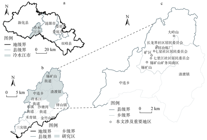
图1
冷水江锡矿山街道区位
注:本图基于“天地图·湖南地理信息公共服务平台”下载的标准地图制作,底图无修改,下同。
Fig. 1
The location of Xikuangshan district in Lengshuijiang
1.2 数据来源
数据包括:2020年土地利用数据(10 m精度),由地理空间数据云获取的ASTER GDEM数据(30 m精度),由NASA-USGS平台获得MODIS蒸散数据、MODIS归一化植被指数产品(NDVI)、MODIS植被净初级生产力数据(NPP),由OSM获得道路路网数据、天地图卫星影像和地形图(1∶10000)。
1.3 研究方法
在资源型城市中实现生态修复和精明收缩的统一,难点在于整合生态安全格局修复、精明收缩理念以及矿区空间规划的多学科思路,实现科学与设计有效结合的空间规划方法,探索“生态分析—政策研究—规划设计”协同工作路径。借鉴Carl-Steinitz提出的地理设计“四类人、六模型、三循环”[36,37] ①(① “四类人、六模型、三循环”框架于2012年在《地理设计框架》中提出。“四类人”明确了参与地理设计的相关人员;“六模型”指待解决问题:“表达模型”从内容、空间和时间上明确研究区域的描述方法,“运作模型”厘清要素间的结构和功能关系,“评价模型”评估运作情况,“变化模型”确定改变的具体实施方式,“影响模型”预测改变可能导致的结果,“决策模型”解答应该如何被改变。“三循环”指思维路径:从“表达模型—决策模型”自上而下顺向循环、从“决策模型—表达模型”自下而上逆向循环以及再次从“表达模型—决策模型”自上而下顺向循环的“S”型路径。),本文构建了包括“分析问题—确定方法—研究方案”三个往复循环的方法框架,从“现状表达、运作机制解析和模拟、现状评价、改变模拟和规划表达、影响评估、决策模拟”六个板块展开工作,协同“生态学、地理学、地理信息技术、城市管理、公共政策、城乡规划、景观修复、更新改造、建筑设计、本地居民、利益相关者”等多类型参与者(图2)。
图2
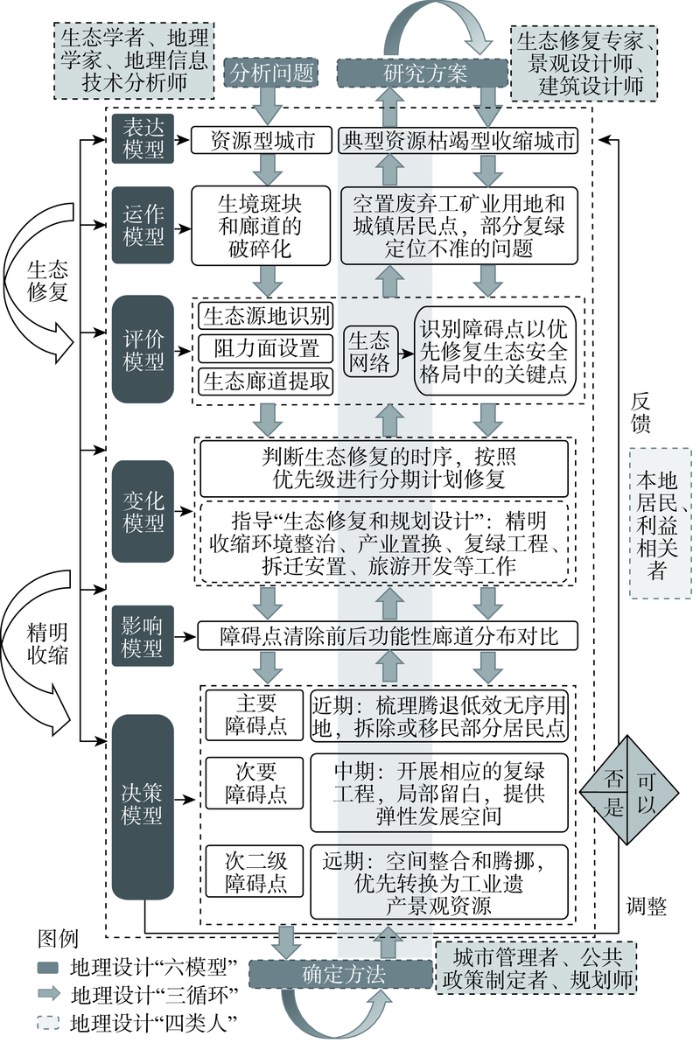
图2
“四类人、六模型、三循环”技术路线
Fig. 2
Research framework of "Four types of people, six models, three cycles"
首先,本文依旧延续“识别生态源地、构建阻力面、提取廊道、获取关键节点、构建生态网络”的一般范式对锡矿山地区进行生态安全格局分析,识别障碍点以优先退出废弃用地并修复生态安全格局中的关键点。其次,本文将生态安全格局研究结果叠合现状土地闲置和房屋空置情况,依据各级障碍点的空间分布特征制定近期、中期和远期修复目标和具体修复内容。最后,利用精明收缩思维,结合现状土地、建筑物使用情况和地区产业转型进度,基于政策可行性来验证规划设计方案,以及时反馈调整,确保生态修复方案的合理性,为有序地进行生态源地保育、生态廊道修复、城市建设用地退出、潜在山水林田湖草的用地功能提升奠定基础(图2)。
1.3.1 生态源地识别
本文中的生态源地[5]指具有较高生境质量、适宜物种维持与扩散的栖息地,是生态系统服务供给的重要区域。由于锡矿山包含大量废弃空置的采矿用地、工业用地、城镇居住用地及其他污染严重的土地,生态环境恶劣;近几年,湖南省自然资源、生态环境部门采取了整治矿山、种植固碳林、治理荒废田地、污染水体和裸露山体等措施,实施山水林田湖草沙系统治理。同时,冷水江政府近期作出了锡矿山绿色转型发展、打造红色旅游与工业旅游的决策②(②《长征国家文化公园(湖南段)建设保护规划建议》将冷水江纳入了长征国家文化公园(湖南段)建设范围。)。基于以上土地修复、环境治理、未来发展谋划方面的需要,本文选取“固碳释氧、生境质量、栖息地风险评估、气候调节服务和水敏感”五种生态系统服务,结合土地利用现状对生态源地进行定量评估(具体计算见表1)。
表1 生态系统服务评估方法
Table 1
| 服务因子 | 评估方法/模型 | 基本原理解释 | 权重 |
|---|---|---|---|
| 土地利用现状 | 提取草地、林地、水体等城市绿色基础设施要素 | 草地、林地、水体具有较高生境质量,可以作为基本生态源地。利用ENVI监督分类解译遥感数据并修正,提取草地、林地、水体等城市绿色基础设施要素作为基本生态源地 | 0.30 |
| 固碳释氧 | InVEST模型③Carbon模块 | 利用地上、地下、土壤和死有机体中每个碳库的最小碳量之和来表示。碳密度相关参数参考前人研究成果[38]与InVEST模型手册确定④ | 0.10 |
| 生境质量 | InVEST模型③Habitat Quality模块 | 以土地利用数据、每一种威胁性土地利用类型的相对影响、生境栅格与威胁因子之间的距离(表2,数据所需相关参数参考InVEST模型手册④,并根据当地情况进行相应调整)、每一类生境对每一种威胁因子的相对敏感性4个因素综合评价维持生物多样性服务[11] | 0.20 |
| 栖息地风险 | InVEST模型③的Habitat Risk Assessment 模块 | 通过判断生境暴露于压力源的可能性及其暴露后果,结合暴露程度与响应值去给每个压力源—生境联合体生成一个对应的风险值,量化所有压力源对生境的累积风险,辨别处于风险热点的生境区域④ | 0.15 |
| 气候调节 | 城市生态智慧管理模型的气候调节(降温)模型 | 以生态系统蒸腾蒸发消耗的能量和植被蒸腾消耗的能量来表征气候调节服务 | 0.10 |
| 水敏感 | 城市生态智慧管理模型的水敏感模型(日常游憩) | 对主要的河流、公园绿地、果园、茶园、坑塘和沟渠,以行人不同时间下的步行距离分别做缓冲区,结合水敏感模型提取不同等级的水敏感范围⑤ | 0.15 |
③ 已有研究大多将InVEST模型应用于宏观尺度,但相关研究一直在建议将其在微观尺度下进行探索应用;考虑到模型在微观尺度下的敏感性和不确定性,首先,本文在“固碳释氧”模型中采用精度高且来源可靠的土地利用数据,提高微观尺度下估算碳储存量的计算结果精度;其次,“生境质量”模型中将锡矿山、中连乡、渣渡镇三个行政区作为研究区范围,拓展纳入分析的景观边界,减少因人工边界划定造成生境威胁被忽视的情况;最后,“栖息地风险评估”模型各类压力源及其暴露后果的信息的评分没有统一标准,本文参考已有的研究进行评分。基于以上,将InVEST模型应用在本案例中的误差在可接受范围之内。
④ 斯坦福大学NATURAL CAPITAL PROJECT的InVEST模型官方网站,
⑤ 城市生态智慧管理模型(Intelligent Urban Ecosystem Management System),
表2 威胁因子属性表
Table 2
| 威胁因子 | 相对权重 | 最大影响距离/km | 空间衰退类型 |
|---|---|---|---|
| 草地 | 0.2 | 2 | 线性 |
| 林地 | 0.2 | 1 | 线性 |
| 城镇建设用地 | 1.0 | 10 | 指数 |
| 农村居民点 | 1.0 | 8 | 指数 |
| 工矿用地 | 1.0 | 10 | 指数 |
| 农业用地 | 0.8 | 6 | 线性 |
| 水域 | 0.2 | 3 | 指数 |
| 裸地 | 1.0 | 10 | 指数 |
| 道路用地 | 0.8 | 6 | 指数 |
研究首先将修正后的土地利用现状图斑重分类,提取林地、草地、水体作为城市绿色基础设施的组成要素,得到研究区的基本生态源地。其次,在基本生态源地上叠加当前碳总量、生境质量评估、生境风险评估、气候调节服务、水敏感服务等因子层,参考已有研究[8]以权重0.3、0.1、0.2、0.15、0.1、0.15分别赋值,选取叠加后面积大于0.1 hm2且各类生态系统服务水平排序前30%的斑块作为最终生态源地。
1.3.2 生态阻力面设置
表3 景观类型阻力赋值
Table 3
| 土地利用 类型 | 亚类 | 阻力值 | 土地利用 类型 | 亚类 | 阻力值 | 土地利用 类型 | 亚类 | 阻力值 |
|---|---|---|---|---|---|---|---|---|
| 林地 | 竹林地 | 1 | 农业用地 | 水浇地 | 30 | 城镇住宅用地 | 正利用500 | |
| 乔木林地 | 1 | 沟渠 | 50 | 废弃300 | ||||
| 灌木林地 | 3 | 水田 | 50 | 公园与绿地 | 250 | |||
| 其他林地 | 5 | 旱地 | 100 | 设施农用地 | 350 | |||
| 草地 | 其他草地 | 5 | 建设用地 | 公用设施用地 | 300 | 采矿用地 | 正利用500 | |
| 水体 | 河流水面 | 7 | 商业服务业设施 用地 | 废弃350 | ||||
| 水库水面 | 9 | 科教文卫用地 | 工业用地 | 正利用500 | ||||
| 农业用地 | 坑塘水面 | 10 | 机关团体新闻出版用地 | 废弃350 | ||||
| 养殖坑塘 | 10 | 水工建筑用地 | 未利用地 | 裸土地 | 300 | |||
| 茶园 | 15 | 物流仓储用地 | 350 | 空闲地 | 250 | |||
| 果园 | 15 | 特殊用地 | 道路用地 | 公路用地 | 300 | |||
| 可调整果园 | 15 | 交通服务场站用地 | 农村道路 | 200 | ||||
| 其他园地 | 15 | 农村宅基地 | 300 | 城镇村道路 用地 | 200 |
表4 地形坡度阻力赋值
Table 4
| 坡度类型 | 坡度范围/(°) | 阻力值 | 高程范围/m | 阻力值 |
|---|---|---|---|---|
| 平坡 | <5 | 1 | 222~300 | 1 |
| 缓坡 | 5~15 | 10 | 301~500 | 10 |
| 斜坡 | 15~25 | 30 | 501~700 | 30 |
| 陡坡 | 25~35 | 50 | 701~900 | 50 |
| 急坡 | >35 | 100 | 900~997 | 100 |
式中:
1.3.3 生态廊道提取
矿山地区各类用地发挥的景观连通性作用不一,通过电路理论⑥(⑥ “电路理论模型(Circuit Theory Model)将物种个体视为电荷,根据不同景观要素对物种迁移的阻碍程度分别赋予电阻值,将研究区视作导电表面,通过电荷在导电表面的游走类比模拟生物的迁移路径,由此获得各源地之间的电流模拟图,识别生态斑块和生态廊道,确定景观连通性的强弱。)模拟可识别区域重要生态斑块与廊道。利用Circuitscape 4.0软件,本文选用成对计算(Pairwise)模式,将所有成对斑块间的电流值合并生成逐像素的累积电流值,以此模拟研究区自然生态景观斑块间的连通性,分析廊道的相对重要性。
1.3.4 障碍点识别与清除
障碍点是物种在生境斑块间运动受到阻碍的区域[41],面积通常较小,但严重降低景观连通性,修复后可显著提升生态源地之间的连通性[42],是应该优先修复的关键区域。由于资源枯竭矿区的生境斑块和廊道已经破碎化,障碍点识别需要从大区域生态安全格局中观察生态廊道的断裂点,并预想实施生态修复可能对区域生态源地连通性显著提升的片区,以其作为生态修复的优先区[21]。同时,希望基于精明收缩制定具体的障碍点清除方案。首先,本文不仅阐明障碍点清除后锡矿山地区的功能性廊道分布特征,还基于典型障碍点的“分期收缩”安排提出节点修复再利用优化顺序。其次,研究依据重要程度划分优先级别来制定精明收缩规划,梳理、腾退废弃工矿用地和城镇居民点,并针对腾退后的土地开展相应退耕退建还林还草还湿等复绿工程。最后,运用城市更新的设计手法,探讨废弃工矿用地和建筑改造利用的可能方案。
2 结果分析
2.1 生态源地和阻力面生成
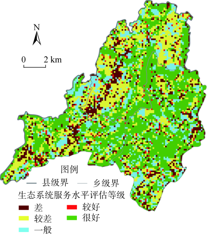
根据土地利用现状评判基本生态源地,结果高值区主要分布于锡矿山街道与渣渡镇连接的地区。该地区岭地林地资源丰富、地势平坦、污染小、距离城市较远,受到城市开发建设活动的影响更小。碳总量高值区多分布于锡矿山街道与渣渡镇连接的边缘地带、东南部和西南部的林地范围。生境质量高值区域分布在东南部山区、中部大岭山,低值区分布在人类活动集聚区。锡矿山工矿用地和其他连片建设用地生境风险大。气候调节服务高值区位于地势较为平坦的林地、草地。水敏感服务低值区大多分布在矿区范围内,以还在利用中的工矿用地为主。基于生态系统服务水平评估结果,研究区共筛选出生态源地36个,总面积30.48 km2(图3)。由图3可见,锡矿山由于存在大量废弃采矿用地、工业用地和城镇居住用地,密集的生产活动和严重的污染对生态空间的干扰程度大,矿区中部形成明显低值洼地,造成了破碎的生态源地分布格局。
图3
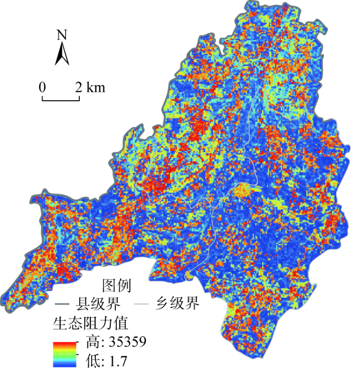
基于坡度和高程数据重分类,叠加公路缓冲区和城镇村道路、农村道路缓冲区修正土地利用赋值的基本阻力系数,得到锡矿山地区最终生态阻力面(图4)。高阻力值地区分布于锡矿山街道中部的上述低值洼地,即矿区、锡矿山矿务局南区、中连乡居民点等,主要原因是矿区生态被侵蚀严重、坡度大,众多废弃工矿业生态破碎化明显,且人类活动集中,活动强度、范围与频次大。
图4
2.2 生态廊道与障碍点的空间分布特征
图5
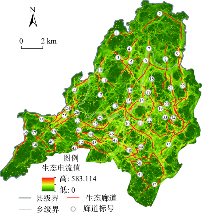
图5
生态廊道相对重要性及空间走向
Fig. 5
The relative importance of ecological corridors and spatial trend
图6
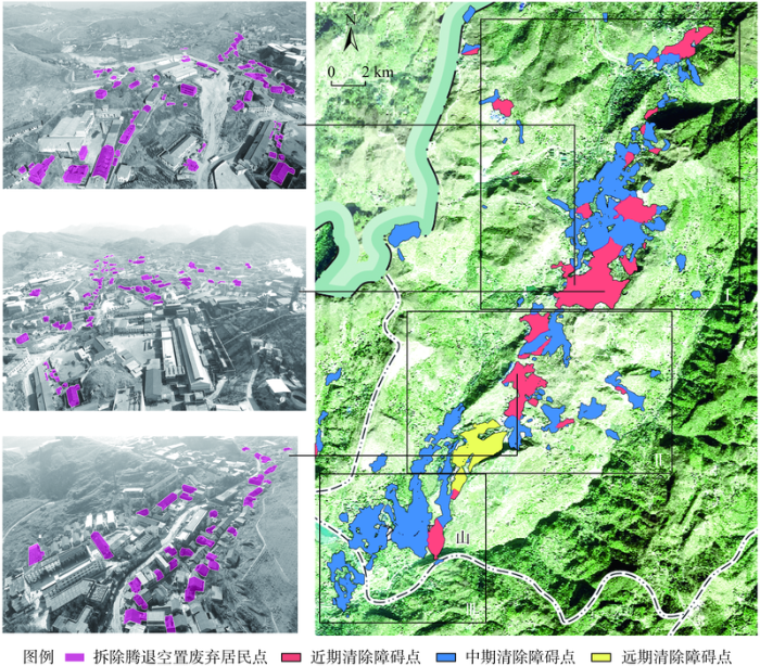
图7
2.3 障碍点的分期修复和精明收缩
锡矿山地区必须在识别障碍点的基础上,考虑功能性廊道的连通性能,依据主要障碍点、次要障碍点和次二级障碍点的优先级程度实施分期收缩,逐渐加强廊道的功能性连接。同时,作为典型的资源枯竭型城市,锡矿山地区障碍点生态修复,必须包含存量和减量规划的政策实施考量,综合运用精明收缩理念进行“有序收缩”和“平滑过渡”[43],结合优先等级确定调整分期,实现在不同空间分布有序发展。
首先,近期应对位于主要障碍点上的废弃工矿用地和城镇居民点进行梳理、腾退。例如,七星社区居民委员会以东、七里江社区居民委员会以西地区连通性廊道断裂面积较大、污染严重,可考虑根据电流密度优先关系,优先将那些流失率较大、产权比较清晰的区域拆迁(图6)。同时,根据电流值大小设定不同的开发等级,限制容积率,规定绿地率,通过渐进式的退出,主动且有计划地转换形成复合型绿色基础设施网络体系,从而实现空间形态有序的逆向收缩。
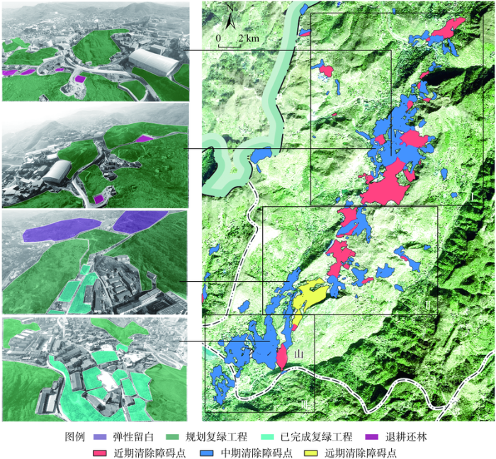
其次,中期应重点关注次障碍点上的耕地、裸地及近期计划中未关注到的废弃工矿业用地和城镇居民点。其中,耕地在污染严重的矿山地区生态贡献率极低,中期生态修复过程中可以考虑对低质量耕地实施退耕还林。例如,长龙界社区居民委员会以南、锡矿山矿务局南区西部和南部,面积较广且生境分割明显,可以结合矿山地质环境修复与植被恢复,拓宽中部工矿业地区的生态廊道(图7)。同时,在分析结果中电流密度较低的区域可以有选择地建设旅游服务设施。此外,根据国土空间规划要求,中期还应当局部留白,注重生态源地边缘区管控,提供弹性发展空间,为远期工业遗产景观规划奠定基础。
最后,远期收缩主要考虑次二级障碍点。由于该部分障碍点现状还是在使用中的工矿企业,远期需要结合冷水江市政府建设地质文化镇的规划,谨慎地主动进行局部收缩,提升用地的效率。建设用地退出所获得的土地优先转换为工业遗产景观,挖掘锡矿山工业旅游潜能。例如,锌冶炼厂(图8b1~图8e1)作为曾经的龙头企业,其厂房、烟囱和管道作为时代记忆,体现了后工业遗址美学,展现出崇高感和敬畏感[44]。其在锡矿山的整体旅游规划中有着较大的更新潜力,同时作为承载了几代人采矿记忆的重要生产空间,未来可将其更新改造为集文化展览、娱乐休闲、科普探索和矿业观光为一体的工业景观公园。未来通过更新设计,可以分区设置科普体验、娱乐休闲、文化展览、儿童探险等主题场馆,结合构筑物、建筑物、展览区以及景观草坪等还原采矿冶炼的流程、体验矿业文化,科普工业生产线文化,重拾厂区记忆,利用儿童探险区和景观草坪提供多样化服务和休憩环境(图8b2~图8e2)。
图8
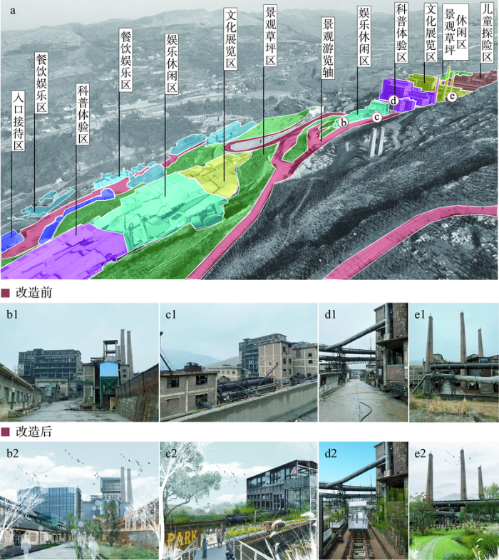
图8
远期障碍点节点修复的土地再利用效果(示意)
Fig. 8
Land reuse plan for the third phase restoration (schematic)
3 结论与讨论
3.1 结论
在快速城镇化过程中,对自然资源的无序开发导致了区域生态质量的不均衡发展。构建国土空间开发保护格局需要有效维持和修复区域内生态流的正常循环过程,建立生态安全格局,持续推进生态修复,维持生态系统健康。本文以锡矿山地区为例,基于生态系统服务水平评估,通过生态源地识别、阻力面设置、生态廊道提取、障碍点识别及生态网络构建,将传统“生态网络”研究范式引入到城市生态修复治理工作中,提出国土空间生态保护与修复中生态优先区识别的方法与途径。并且,依据优先程度实施分期分区收缩,有针对性地消除或弱化生态负面效应,提升生态系统结构连通性与功能完整性,有计划地控制和调整空间要素,主动收缩且谨慎地进行生态修复并落地实践。本文希望将生态安全格局分析方法和资源枯竭矿区空间收缩研究相结合,探索符合资源枯竭矿区具体的分步式生态修复路径,以其土地利用和空间形态分期、有序地实现精明收缩和地理设计方法。
3.2 讨论
本文提出资源型城市生态安全格局修复中的精明收缩方法,将传统生态安全格局修复研究范式引入到收缩城市空间治理中,运用生态安全格局的分析技术手段作为精明收缩的空间形态管控的基础,实现科学与设计有效结合。利用地理设计“四类人、六模型、三循环”框架模型,研究提出融合“生态分析—政策研究—规划设计”的技术路线,对锡矿山地区的案例研究证明其具有可行性。
在冷水江案例研究中,对比修复障碍点前后研究区电流值的大小进行生态廊道恢复情况检验。可以发现,障碍点清除前,锡矿山地区最大电流值为424.79 A,存在的功能连通性廊道数量较少(图9a);如果顺利清除后锡矿山地区最大电流提升为463.29 A,中部新增三条功能连通性廊道,废弃空置工矿业地区结构性廊道围合的区域内部功能连通性得到改善,形成网状结构(图9b),修复这些障碍点不仅可以为研究区提供多条功能连通性廊道,也提升了生态系统抵御各种风险的能力。此外,由于考虑矿区废弃工矿用地和城镇居民点梳理和腾退工作要求、人口流失和产权情况,以及冷水江市政府建设地质文化镇的规划要求,本文提出的障碍点的分期修复和精明收缩分期方案能够与地方发展的政策需求和规划实施具有较高的贴合度。
图9
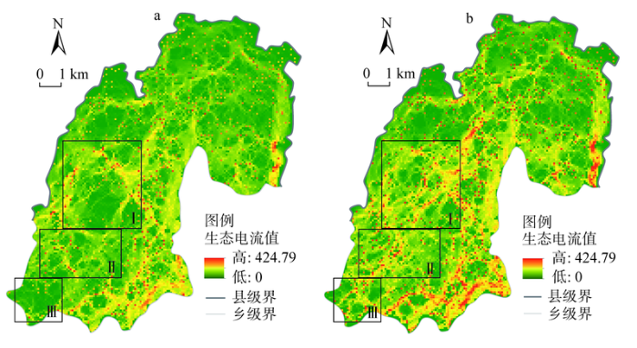
图9
障碍点清除前后功能性廊道的变化比较
Fig. 9
Comparison of changes in functional corridors before and after barrier point removal
该方法潜在的创新性在于:在当前独立存在的精明收缩研究与生态安全格局修复之间的交叉领域,补充运用定量分析技术指导制定最合理的精明收缩和生态修复步骤。一方面,试图推动资源型城市生态安全格局修复的落地实施,通过准确制定精明收缩的分期安排,实现在不同空间有序收缩;另一方面,探索了资源型城市面临收缩时的生态安全格局修复工作思路,为资源枯竭型收缩城市计划地、系统地开展生态修复提供参考。此外,在未来研究中,还需要进一步探索如何在现有修复策略基础上整合已实施的修复工程,同步修复障碍点,提升区域整体生态状况,形成城市、乡村等人类聚落的协同耦合,实现系统修复和综合治理。
参考文献
冀西北间山盆地区景观格局变化及优化研究: 以河北省怀来县为例
Study on the change and optimization of landscape pattern in the basin of Northwest Hebei Mountains: A case study of Huailai county, Hebei province
基于生态供需视角的生态安全格局构建与优化: 以长三角地区为例
Ecological security pattern construction method based on the perspective of ecological supply and demand: A case study of Yangtze River Delta
基于生态系统服务的流域生态安全格局构建: 以辽宁省辽河流域为例
Constructing ecological security pattern based on ecosystem services: A case study in Liaohe River Basin, Liaoning province, China
基于“源—汇”理论的生态型市域景观生态安全格局构建
Landscape ecological security patterns in an ecological city based on source-sink theory
基于MSPA和MCR模型的江苏省生态网络构建与优化
Developing and optimizing ecological networks based on MSPA and MCR model
包头市层级生态网络构建方法研究
Construction method of hierarchical ecological network in Baotou city
雄安新区生态安全格局识别与优化策略
DOI:10.11821/dlxb201804009
[本文引用: 2]

雄安新区的设立对于调整、优化京津冀城市空间结构具有深远的历史意义。面向“生态标杆”的新区建设理念,生态安全格局识别及优化是保障雄安新区生态安全、实现可持续发展的基本空间途径。本文基于雄县、容城、安新三县生态本底特征,选取并定量评估粮食供给、产水、土壤保持、生境维持和近水游憩5种生态系统服务,识别生态源地;利用VIIRS/DNB夜间灯光数据修正基于地类赋值的基本阻力面,并运用最小累积阻力模型识别生态廊道;最后基于现状生态安全格局,探讨绿色生态宜居新城目标下的生态安全格局优化策略。研究结果表明:雄安三县生态源地占到全区土地总面积的41.88%,包含14个生态源地斑块,主要分布在白洋淀周边;生态廊道总长度107.21 km,分4大组团呈环状分布;现有生态源地辐射面积占到全区的70.6%,在雄县县城周边新建辐射面积为227 km<sup>2</sup>的生态源地可满足全区85%的源地辐射面积规模要求。本文提出的生态安全格局优化方案可为雄安新区开发建设提供空间指引。
Identification and optimization of ecological security pattern in Xiong'an New Area
DOI:10.11821/dlxb201804009
[本文引用: 2]
The establishment of Xiong'an New Area has far-reaching historical significance for adjusting and optimizing the urban layout and spatial structure of Beijing-Tianjin-Hebei region. Under the construction concept of ecological benchmark, the identification and optimization of ecological security pattern is the basic spatial approach to ensuring the ecological security and realizing sustainable development in Xiong'an New Area. Based on the ecological background characteristics of Xiongxian, Rongcheng and Anxin, this study quantified and mapped five ecosystem services, namely grain yield, water yield, soil conservation, habitat conservation and near water recreation, and identified the ecological sources. Using the VIIRS/DNB Nighttime Light data, ecological resistance surface based on land-use types assignment was modified. The minimum cumulative resistance model was used to identify the ecological corridors. Based on the current ecological security pattern, the optimization strategy of the ecological security pattern was discussed under the goal of green, ecological and livable city. The results showed that, ecological sources, which accounted for 41.88% of the total area and contained 14 major ecological patches, were mainly distributed in the areas surrounding the Baiyangdian Lake. The total length of ecological corridors was 107.21 km, which was divided into four groups with a circle distribution. The radiating area of existing ecological sources reached 70.6% of the total area. Therefore, it is necessary to build a new ecological source with a radiating area of 227 km2 to meet the demand for 85% of radiating area of the ecological source. The ecological security pattern scheme proposed in this study can provide spatial guidance for the construction of green, ecological, and livable city in Xiong'an New Area.
基于“重要性—敏感性—连通性”框架的云浮市生态安全格局构建
DOI:10.11821/dlyj201703006
[本文引用: 4]
生态安全格局构建是保障城市生态安全,实现城市可持续性发展的重要途径,也是景观生态学研究的热点领域之一。生态源地识别与空间阻力面构建一直是生态安全格局构建中的技术难点。以广东省云浮市为例,从生态系统服务重要性、生态敏感性与景观连通性三个方面识别生态源地,利用DMSP/OLS夜间灯光数据修正基本生态阻力面,并运用最小累积阻力模型判定生态廊道,从而综合构建云浮市生态安全格局。研究表明:云浮市生态源地占全市总面积的36.47%,主要分布在西部与南部的山林地。云浮市生态廊道总长度为508.87 km,其中景观廊道总长度为315.58 km,组团廊道总长度为193.29 km,呈环状辐射分布于植被覆盖相对较好的山区地带。全市16个自然保护区基本都位于生态源地范围内。构建的“重要性—敏感性—连通性”框架可以为区域生态安全格局构建提供新思路,从而有效指引相关空间规划。
Constructing ecological security patterns in Yunfu city based on the framework of importance-sensitivity-connectivity
DOI:10.11821/dlyj201703006
[本文引用: 4]
Construction of ecological security patterns is an important approach to protecting urban ecological security and achieving urban sustainable development, which is one of key topics in the research of landscape ecology. The identification of ecological sources and the construction of spatial resistance surface have been the technical difficulties in the study of ecological security pattern. Yunfu city is the significant ecological hinterland of Guangdong Province with the backward economy, which is facing the pressure of ecological conservation as well as economic development. Thus, construction of ecological security pattern in Yunfu city can guide urban development and is also meaningful for protecting provincial ecological security. Based on GIS, ecological sources were identified from the aspects of ecosystem services' importance, ecological sensitivity, and landscape connectivity. On the basis of DMSP/OLS Nighttime Light data, ecological resistance surface was modified, and using minimum cumulative resistance model, ecological corridors were identified. The ecological sources with corridors constituted regional ecological security patterns. The results showed that, the area of ecological sources accounted for 36.47% of the total area, mainly distributed in mountainous area in western and southern Yunfu, which took forest as the main land cover type. The length of ecological corridors was 508.87 km, including 315.58 km landscape corridors and 193.29 km cluster corridors. It was also found that all the 16 nature reserves were in the range of ecological sources, and the constructed ecological security patterns and the layout of urban master planning complemented each other. The framework of importance-sensitivity-connectivity can provide a new method for the construction of regional ecological security patterns, and the study results can provide related planning with effective spatial guidance.
基于地质灾害敏感性的山地生态安全格局构建: 以云南省玉溪市为例
DOI:10.13287/j.1001-9332.201702.013
[本文引用: 1]
区域生态安全格局构建作为景观生态学的研究热点之一,为区域可持续发展和国土生态屏障建设提供了重要途径,尤其对于灾害频发、生态脆弱的滇中地区,其能够有效规避自然灾害、促进区域生态系统和社会经济系统协调发展.本文以玉溪市为例,针对区域生态环境基底特征,选取水源涵养、固碳释氧、土壤保持和生物多样性等生态系统服务评估自然生境重要性,综合考虑单一类型生态系统服务质量和多功能性识别生态源地;并采用地质灾害敏感性修正基于地类赋值的基本阻力面,运用最小累积阻力模型识别生态廊道,从而构建玉溪市生态安全格局.结果表明: 玉溪市生态源地斑块数量为81个,占玉溪市土地总面积的38.4%,与各级自然保护区重合率达75.2%,主要分布在市域西部的山林地和东部的湖泊湿地区域;玉溪市生态廊道总长度1642.04 km,呈“一横三纵”的空间分布格局,沿河谷、断陷盆地等植被覆盖较好的区域延伸.本文针对滇中山地生态脆弱区地质灾害频发特征,构建山地生态安全格局,对于区域山地开发与生态保护能够提供决策指引.
Constructing ecological security patterns in mountain areas based on geological disaster sensitivity: A case study in Yuxi city, Yunnan province, China
佛山市生态网络构建及优化
DOI:10.13287/j.1001-9332.202109.019
[本文引用: 1]
在快速城市化背景下,经济发达地区生境斑块破碎化问题尤为突出,生物多样性受到严重威胁,构建生态网络是连接生境斑块和保护生物栖息地的重要手段。本研究以发展较快的广东省佛山市为研究区域,利用连接度指数和形态学空间格局分析方法提取出生态源地,基于InVEST模型和最小累积阻力模型识别出潜在生态廊道,结合水文分析所提取出的辐射道,共同构建佛山市生态网络。通过增加生态源地和踏脚石、识别生态断裂点对生态网络进行优化,最后基于网络分析法和电路理论,从结构和功能两方面对优化前后的网络进行评价。结果表明: 佛山市生态网络由10个生态源地、8条重要廊道、37条一般廊道和11条辐射道构成。优化后新增生态源地7个、规划廊道17条、踏脚石13个、生态断裂点80个;优化后的生态网络闭合度指数、线点率指数、连接度指数分别为0.59、1.94、0.73,优化后的电流密度最大值由1.39升高至9.66,说明优化后的生态网络结构更加完善、连通性显著提升。
Ecological network construction and optimization in Foshan city, China
基于MSPA和电路理论的南宁市国土空间生态网络优化研究
Research on the optimization of territorial space ecological network of Nanning city based on MSPA and circuit theory
The shrinking mining city: Urban dynamics and contested territory
DOI:10.1111/j.1468-2427.2011.01094.x URL [本文引用: 1]
收缩城市量化计算方法进展
Research on quantitative calculation method of shrinking city
湖南省多地理尺度下的人口“收缩地图”
DOI:10.11821/dlyj201702006
[本文引用: 1]
基于收缩城市理论,在省域、地州市、县市区和乡镇街道尺度下对湖南人口收缩现象进行定量分析。在全省人口增速放缓和劳动力缩减趋势下,湖南未来的“本地城镇化”和“人口回流”将延续或加剧部分边缘地区的人口收缩。当前各地州市发展规划中的人口和用地增长预期过高,未来人口资源和空间资源分布不相匹配。通过比较人口、城镇化和经济增长数据,总结出三种县市人口收缩类型:“中心袭夺型”、“空心衰减型”和“资源枯竭型”。通过绘制乡镇街道尺度的湖南人口“收缩地图”,发现人口增长在地级、县级中心城市周边集聚,而其他乡镇收缩明显且集聚显著,县级城市是湖南省人口增长/收缩的损益边缘。建议决策者应当开始认识收缩的问题和机遇,建立“紧缩”适宜的空间开发格局,并利用收缩机遇期,实现城镇减量提质。
A multi-scaled analysis of the "Shrinking Map" of the population in Hunan province
DOI:10.11821/dlyj201702006
[本文引用: 1]
Using the international "shrinking city" theoretical framework and China's Fifth and Sixth National Population Census data, this study conducted quantitative analyses regarding the shrinking population phenomenon at multiple geographical scales, from provincial to township, in Hunan Province in central China. From a statistically based forecast at the provincial level, a forthcoming slowing of total population growth and an ongoing decline of the labor pool (population aged 16-64 years) was discovered. Based on these predictions, Hunan's urbanization process in the next decade can be expected to be driven mainly by either further in-situ urbanization or the possible return of migrants, which could exacerbate population shrinkage in some marginal areas. By comparing historical demographic data with planning proposals collected at the prefectural level, the study reveals that targets are too high in the expectations for further population growth that are contained within planning documents. In reality, there is a clear mismatch between population distribution, migration patterns, and planned land quota allocation schemes for future development of cities in Hunan. At the county level, this study compared data on population change with the urbanization and gross domestic product growth rates from 2000 to 2010. From this, three main types of shrinkage were identified at the county scale: "population taking over", wherein population outflow and the economy develop slowly in urbanizing areas affected by central cities nearby that develop rapidly; "labor hollowing-out", wherein the population shrinks and the economy develops slowly in low-level urbanizing areas because of labor output; and "resource degrading". Meanwhile, census data at the township level paint a detailed picture of population shrinkage in Hunan Province. It suggests a statistically significant clustering of population growth in major prefecture- and county-level cities, which are surrounded by generally scattered shrinking regions. As shown on the "shrinking map" in this study, county-level cities were seated at the very edge of population gain or loss in the process of urbanization, which means they should function as main destinations of the internally urbanized population in the future (i.e., in-situ urbanization). Finally, this study suggests that the provincial government prepared for coming decades of population shrinkage, and started to find alternative urbanization pathways during the labor population decline. A "compact and shrinking" spatial planning framework is needed to secure sustainable urban growth, while also taking shrinking as an opportunity to develop compact, but higher quality, urban spaces.
基于“精明收缩”理论的广州城边村空间规划对策
Smart shrinkage orientated urban fringe village planning, Guangzhou
How does(n't) urban shrinkage get onto the Agenda? Experiences from Leipzig, Liverpool, Genoa and Bytom
DOI:10.1111/1468-2427.12101 URL [本文引用: 1]
Urban shrinkage as an emerging concern for European policymaking
DOI:10.1177/0969776413481371 URL [本文引用: 1]
Policy responses to urban shrinkage: From growth thinking to civic engagement
DOI:10.1080/09654313.2013.793655 URL [本文引用: 1]
Varieties of right-sizing strategies: Comparing degrowth coalitions in French shrinking cities
DOI:10.1080/02723638.2017.1332927 URL [本文引用: 1]
Urban shrinkage in Germany and the USA: A comparison of transformation patterns and local strategies
Many American and European cities have to deal with demographic and economic trajectories leading to urban shrinkage. According to official data, 13% of urban regions in the US and 54% of those in the EU have lost population in recent years. However, the extent and spatial distribution of declining populations differ significantly between Europe and the US. In Germany, the situation is driven by falling birth rates and the effects of German reunification. In the US, shrinkage is basically related to long-term industrial transformation. But the challenges of shrinking cities seldom appeared on the agendas of politicians and urban planners until recently. This article provides a critical overview of the development paths and local strategies of four shrinking cities: Schwedt and Dresden in eastern Germany; Youngstown and Pittsburgh in the US. A typology of urban growth and shrinkage, from economic and demographic perspectives, enables four types of city to be differentiated and the differences between the US and eastern Germany to be discussed. The article suggests that a new transatlantic debate on policy and planning strategies for restructuring shrinking cities is needed to overcome the dominant growth orientation that in most cases intensifies the negative consequences of shrinkage.
Life within and life of a mining town: The historical geography of Western Australia's first iron ore town
DOI:10.1080/00049182.2017.1398121 URL [本文引用: 2]
中部地区资源型城市城市化与生态环境动态耦合关系
Coupling relationship change between urbanization and eco-environment of resource-based cities in Central China
Incorporating biodiversity conservation and recreational wildlife values into smart growth land use planning
DOI:10.1016/j.landurbplan.2010.11.014 URL [本文引用: 1]
资源枯竭型城市增长边界划定研究: 以淮北市为例
Urban growth boundary delimitation of resource-exhausted cities: A case study of Huaibei city
基于资源环境承载力的合肥市增长边界划定
DOI:10.11821/dlyj201312024
[本文引用: 1]
在快速城市化和主体功能区战略背景下,滨湖城市作为城湖共生体,具有湖泊生态系统和城市社会经济系统双重属性,既是中国新型城市化格局中最具活力和潜力的核心单元之一,又是湖泊生态环境问题集中激化的高度敏感区,保护与开发并重,发展与风险共存。以行政区划调整后将巢湖纳入内湖的新合肥市为例,借助GIS平台,运用单因子评价法和综合敏感性评价法构成城市生态适宜性评价的方法体系,以水域因子、坡度因子、湿地因子、覆被因子、灾害风险因子组建资源环境约束指标体系,将合肥市域划分为极高敏感区、高敏感区、中敏感区、低敏感区、非敏感区5 种资源环境承载类型区;基于反规划理念,构建滨湖城市空间增长模型,并划定作为城市扩展生态底线的刚性和弹性空间增长边界。在此基础上,统筹考虑城市空间资源环境保障能力、人口与用地规模,结合城市总体规划方案,明确城市空间扩展方向,科学划定城市近期、中期和远期的增长边界。该方法在中国滨湖城市的空间增长规模与方向、湖泊生态系统安保与开发、城市用地调控与优化组合以及城市规划方案的合理性评价方面可提供科学决策依据。
Urban growth boundary delimitation of Hefei city based on the resources and environment carrying capability
DOI:10.11821/dlyj201312024
[本文引用: 1]
Under the context of rapid urbanization and primary function area strategy, a lakeshore city, as a lake-urban symbion, has the dual characteristics of lake ecosystem and urban socio-economic system. The city is not only the most energetic and potential core unit in future urbanization framework, but also the highly sensitive region and the major harnessing region with a series of lake ecologic environmental problems. Therefore, the regional planning of this area has both development potential and high risk and should take both protection and development into consideration. This project focuses on researching the real problems which need prompt solutions during lakeshore city development. With new Hefei as an example, the main objective of this project is to examine the problems of lakeshore city development based on watershed resource environmental carrying capacity. It also explores the driving factors of city growing boundary, constraint mechanism and variation. Learning from the anti-planning concepts, this project delineates the urban spatial growing boundary through building an index system of resource and environment constraints and the spatial growing model of lakeshore city. Moreover, by applying the growing boundary and land use comparative model, this project delimits regulatory and control range and also proposes the optimal regulation and control pathway and effective spatial growing framework. Based on the major objectives, this project tends to provide scientific basis of decision-making on the spatial growing scale and direction, the protection and development of lake ecosystem, industrial spatial optimal combination, the improvement of human living environment and reasonable assessment of urban planning.
Smart growth planning for climate protection
DOI:10.1080/01944363.2011.645272 URL [本文引用: 1]
基于精明发展的城市绩效与生态环境耦合研究: 以哈长城市群为例
DOI:10.13249/j.cnki.sgs.2017.07.008
[本文引用: 1]
城市精明发展与生态环境耦合协调是形成节约型空间格局和可持续发展的重要战略目标。基于“十一五”规划基期2006年至“十二五”规划后期2014年以来的哈长城市群统计数据,从空间发展维度、福利发展维度、消耗发展维度和管理发展维度考量哈长城市群城市绩效的精明发展程度,从而在构建耦合协调度模型的基础上对哈长城市群总体耦合协调发展程度、空间耦合协调特征进行分析。结果表明:① “十一五”规划期间哈长城市群城市绩效与生态环境之间综合发展水平、耦合协调程度均实现西部集聚式空间分布,东部地区综合发展水平有待提高,耦合协调性亟待实现均衡式发展;“十二五”规划时期二者综合发展水平仍以哈长城市群西部为优势区域,耦合协调程度再次呈现分散式布局。② 2006~2014年研究期内哈长城市群除长春市、吉林市和绥化市外,城市绩效与生态环境综合发展水平均呈现微弱回落后继续增长的态势,耦合水平则出现明显下滑,仅有四平市、辽源市、哈尔滨市和齐齐哈尔市二者协调关系正向积极推进。③ 哈长城市群整体城市绩效与生态环境综合发展水平、耦合强度和协调程度不高,但是区域分布差异相对明显,综合发展水平与耦合协调度之间存在一定的空间对应关系,总体实现空间良性共振。
Coupling research between urban performance and ecological environment based on smart development: A case study of Harbin-Changchun city group
DOI:10.13249/j.cnki.sgs.2017.07.008
[本文引用: 1]
The coupling coordination between urban smart development and ecological environment is the important strategic objective in forming conservation-oriented spatial pattern and sustainable developments. Based on the statistics of Harbin-Changchun City Group from the pre-period Year 2006 of "the eleventh five-year plan"to the later-period Year 2014 of “the twelfth five-year plan”, we should take a further consideration about smart development degree of urban performance within the Harbin-Changchun City Group from the following dimensions such as spatial development dimension, welfare development dimension, consumption development dimension and management development dimension. According to the construction of the coupled coordination model, it analyzes the overall coupling and coordinated development degree, spatial coupling coordination characteristics of Harbin-Changchun City Group is also included. As a result, it shows that: 1) During “the eleventh five-year plan”, the comprehensive development level and coupling coordination degree of urban performance and ecological environment in Harbin-Changchun City Group, both of them realize the gathering spatial distribution in western areas. To the contrast, the comprehensive development level in eastern regions needs to be improved and the coupling coordination should be balanced. During the period of “the twelfth five-year plan”, the comprehensive development level of the two is still dominated by western areas. The degree of coupling coordination shows a decentralized layout again. 2) In the study period from 2006 to 2014, it reveals that the comprehensive development level of urban performance and ecological environment in Harbin-Changchun City Group takes the trends of a little falling and then increasing except Changchun City, Jilin City and Suihua City. However, the coupling coordination degree appears to take an obvious decline and the two coordinating relations are actively promoting only in Siping City, Liaoyuan City, Harbin City and Qiqihar City. 3) In the whole Harbin-Changchun City Group, the comprehensive development level, coupling strength and coordination degree are not of great advantages, in the other hand, it is relatively different in regional distributions. There is a certainly spatial correspondence between comprehensive development levels and coupling coordination degrees. And it makes a benign resonance in the space as a whole. Smart development is an inevitable choice for China’s sustainable development under the background of tight resources and environmental problems. Judging from the degree of coupling coordination in the study area which is regarded as the core corridor and pivot of China’s trade facing towards Russia and Northeast Asia, Harbin-Changchun City Group is also in close cooperation with the Beijing-Tianjin-Hebei region and other vertical hinterlands at the same time. We can make a conclusion that the smart development degree of urban performance is of significant regional difference. Therefore it is particularly important to achieve harmonious and sustainable development of urban performance as well as the ecological environment in order to gradually take pace in smart development path and push forward economic and social new normal development actively especially in Harbin-Changchun City Group.
Modelling the urban heat island effect of smart growth policy scenarios in Brisbane
DOI:10.1016/j.landusepol.2017.02.027 URL [本文引用: 1]
中国城市土地集约与生态利用协同度测度: 以31个省会城市为例
Synergy degree between urban land intensification and ecological use in China: A case study of 31 provincial capitals
“危机”抑或“契机”?应对收缩城市空置问题的国际经验研究
"Crisis" or "Opportunity"? International experiences in dealing with vacancy in shrinking cities
收缩情境下城市土地利用及其生态系统服务的研究进展
Research progress of urban land use and its ecosystem services in the context of urban shrinkage
DOI:10.31497/zrzyxb.20190517 URL [本文引用: 2]
Does demolition improve biodiversity? Linking urban green space and socioeconomic characteristics to avian richness in a shrinking city
DOI:10.1007/s11252-017-0671-4 URL [本文引用: 2]
Asset or liability? Ecological and sociological tradeoffs of urban spontaneous vegetation on vacant land in shrinking cities
DOI:10.3390/su10072139 URL [本文引用: 1]
Greening the rust belt: A green infrastructure model for right sizing America's shrinking cities
DOI:10.1080/01944360802354956 URL [本文引用: 1]
精明收缩理论视角下苏南乡村空间发展策略
Southern Jiangsu village space development strategies from shrink Smart viewpoint
自然资源部统筹下的新型地理设计思路探索
New geography design under the governance of national resource bureau
地理设计简述: 概念、 框架及实例
An introduction to GeoDesign: Concept, framework and practice
Assessing the impact of anthropogenic activities on the ecological quality of arid Mediterranean ecosystems (case study from the northwestern coast of Egypt)
DOI:10.1016/j.ecolind.2019.02.005 URL [本文引用: 1]
湖南省城市群生态网络构建与优化
Developing and optimizing ecological networks in urban agglomeration of Hunan province, China
基于生态安全格局的国土空间生态保护修复关键区域诊断与识别: 以烟台市为例
Determining and identifying key areas of ecosystem preservation and restoration for territorial spatial planning based on ecological security patterns: A case study of Yantai city
DOI:10.31497/zrzyxb.20200116 URL [本文引用: 1]
资源型城市工矿用地系统修复的生态安全格局构建
Construction of ecological security pattern for systematic restoration of industrial and mining land in resource-based cities
DOI:10.31497/zrzyxb.20200114 URL [本文引用: 1]
收缩城市的形态控制: 断面模型与精明收缩的耦合框架
To regulate the urban form of shrinking city: A coupling framework of transect models and smart shrinkage
