
过去30年气候和土地利用变化对海河流域径流、泥沙及氮磷流失的影响
|
丁楠(1993- ),女,上海人,博士,研究方向为全球变化与区域生态、全球变化生态学。E-mail: 772746203@qq.com |
收稿日期: 2023-05-07
修回日期: 2024-04-12
网络出版日期: 2024-07-10
基金资助
中澳合作项目(177GJHZ2022052MI)
Effects of climate change and land use change on runoff, sediment, nitrogen and phosphorus losses in the Haihe River Basin
Received date: 2023-05-07
Revised date: 2024-04-12
Online published: 2024-07-10
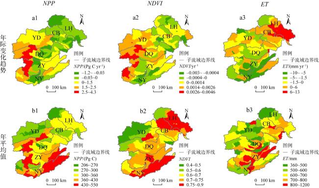
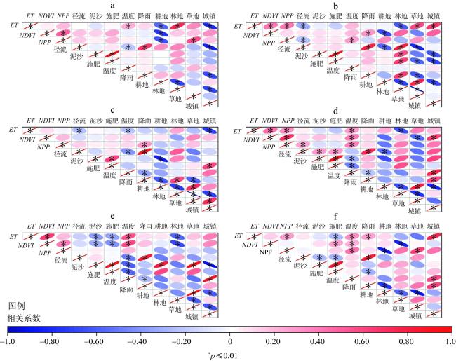
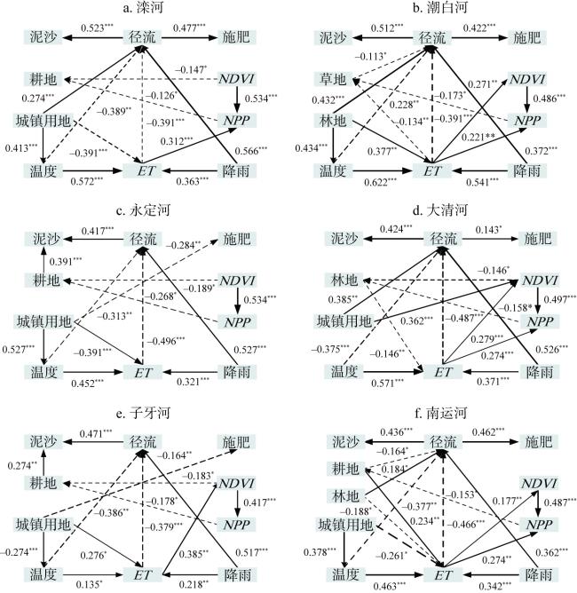
海河流域在国民经济可持续发展中发挥着重要作用,同时也是中国水资源最为短缺的地区之一。人口密集、长期不适当的人类活动和气候变化加剧了该区水土流失和水资源短缺等问题。因此,研究气候变化和土地利用对海河流域径流、泥沙以及氮磷流失的影响,不仅可为流域水沙灾害的预警提供理论支撑,也可为理解流域生态环境演变规律提供重要科学依据。对1985—2015年海河流域气候、土地利用、蒸散发(ET)、归一化植被指数(NDVI)和净初级生产力(NPP)等时空演变规律及其影响机制进行了解析。研究结果表明:(1)海河流域六个子流域中,各变量(ET、NDVI、NPP、径流、泥沙、氮磷等)之间的相关性存在显著的地域差异;(2)温度和降雨直接影响径流,从而间接地影响泥沙和氮磷流失;(3)蒸散发受到温度和降雨影响,直接影响径流,并间接影响泥沙和氮磷流失。由此揭示了过去30年气候和土地利用变化对径流、泥沙及氮磷流失的影响机制,对于理解流域生态环境演变规律及其调控具有重要意义。
丁楠 , 李义博 , 陶福禄 . 过去30年气候和土地利用变化对海河流域径流、泥沙及氮磷流失的影响[J]. 自然资源学报, 2024 , 39(7) : 1720 -1734 . DOI: 10.31497/zrzyxb.20240713
The Haihe River Basin plays an important role in the sustainable economic development of the national economy and is also one of the most water-scare regions in China. Densely populated, long-term inappropriate human activities and climate change have exacerbated the problems of soil erosion and water scarcity in the region. Therefore, studying the effects of climate change and land use on runoff, sediment, and nitrogen and phosphorus losses in the Haihe River Basin provides not only theoretical support for the early warning of water and sand hazards in the region, but also an important scientific basis for understanding the evolutionary pattern of the basin's ecological environment. In this study, we analyzed the spatial and temporal evolution patterns of climate, land use, evapotranspiration (ET), normalized vegetation index (NDVI), and net primary productivity (NPP) in the Haihe River Basin from 1985 to 2015 and their influence mechanisms. The results show that: (1) There are significant geographical differences in the correlations among the variables (ET, NDVI, NPP, runoff, sediment, nitrogen and phosphorus, etc.) in the six sub-basins of the Haihe River Basin. (2) Temperature and precipitation directly affect runoff, and thus indirectly affect sediment and nitrogen and phosphorus losses. (3) ET is directly affected by both temperature and precipitation, and it directly affects runoff, and then indirectly affects sediment and nitrogen and phosphorus losses. The paper reveals the influence of climate and land use changes on runoff, sediment and nitrogen and phosphorus losses over the past 30 years, which is of great significance to the understanding of the evolution of the ecological environment of the basin and its regulation.
Key words: Haihe River Basin; land use; climate change; ecohydrology
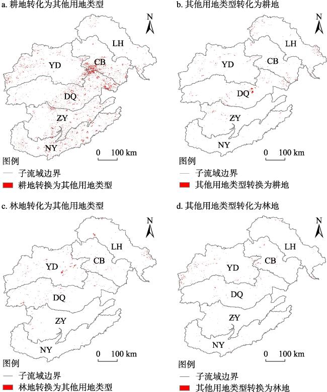
图2 1985—2015年海河流域土地利用变化Fig. 2 Land use change in the Haihe River Basin from 1985 to 2015 |
表1 海河流域各用地类型之间的面积转换Table 1 Area conversion among land use types in Haihe River Basin (km2) |
| 用地类型变化 | 耕地 | 林地 | 草地 | 未利用地 | 城镇建设用地 | 水域 | 面积变化 |
|---|---|---|---|---|---|---|---|
| 耕地 | 133085 | 480 | 259 | 469 | 5897 | 45 | -7150 |
| 林地 | 275 | 56415 | 671 | 16 | 230 | 5 | -1197 |
| 草地 | 425 | 258 | 56641 | 97 | 391 | 151 | -1322 |
| 未利用地 | 568 | 39 | 26 | 4942 | 177 | 18 | -828 |
| 城镇建设用地 | 46 | 3 | 5 | 12 | 16628 | 0 | -66 |
| 水域 | 124 | 1 | 166 | 30 | 63 | 1958 | -894 |
| 面积变化 | +1438 | +781 | +1127 | +624 | +6758 | +219 |
注:“+”表示相应的用地类型面积增加;“-”表示相应的用地类型面积减少。 |
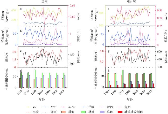
图4 1985—2015年滦河和潮白河相关指标年际变化趋势Fig. 4 Annual variation trend of related indicators for the Luanhe River and Chaobai River from 1985 to 2015 |
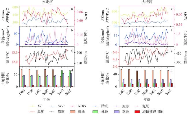
图5 1985—2015年永定河和大清河相关指标年际变化趋势Fig. 5 Annual variation trend of related indicators for the Yongding River and Daqing River from 1985 to 2015 |
表2 部分指标之间偏相关分析相关系数rTable 2 Partial correlation analysis of correlation coefficient r among some indicators |
| 相关系数 r | 温度- NDVI | 降雨- NPP | 降雨- NDVI | 径流- 降雨 | 温度- ET | 降雨- ET | 温度- 泥沙 | 耕地- ET | 林地- ET | 林地- 径流 | 林地- 泥沙 | 林地- 施肥量 | 林地- 降雨 |
|---|---|---|---|---|---|---|---|---|---|---|---|---|---|
| 滦河 | 0.058 | 0.18 | 0.15 | 0.66 | 0.38 | 0.13 | 0.12 | 0.53 | -0.42 | 0.13 | 0.26 | 0.28 | 0.23 |
| 潮白河 | 0.4 | 0.2 | 0.44 | 0.79 | 0.4 | 0.18 | 0.076 | 0.46 | -0.53 | 0.83 | 0.55 | 0.48 | 0.56 |
| 永定河 | 0.09 | 0.39 | 0.19 | 0.57 | 0.49 | 0.4 | -0.34 | 0.4 | -0.37 | 0.033 | 0.44 | -0.51 | 0.26 |
| 大清河 | 0.62 | 0.34 | 0.09 | 0.53 | 0.53 | 0.12 | -0.47 | 0.21 | -0.11 | 0.68 | 0.29 | -0.79 | 0.05 |
| 子牙河 | 0.72 | 0.23 | 0.33 | 0.52 | 0.67 | 0.23 | -0.63 | 0.39 | 0.06 | 0.39 | -0.92 | 0.94 | 0.14 |
| 南运河 | 0.13 | 0.28 | 0.022 | 0.48 | 0.23 | 0.08 | 0.14 | 0.62 | -0.27 | -0.04 | 0.15 | -0.12 | 0.12 |
| [1] |
王全九, 赵光旭, 刘艳丽, 等. 植被类型对黄土坡地产流产沙及氮磷流失的影响. 农业工程学报, 2016, 32(14): 195-201.
[
|
| [2] |
|
| [3] |
曹晓娟, 谢林妤, 张风宝, 等. 沙层特性对沙盖黄土坡面产流产沙变化贡献的定量分析. 地理学报, 2019, 74(5): 962-974.
[
|
| [4] |
马恩朴, 蔡建明, 林静, 等. 近30年中国农业源氮磷排放的格局特征与水环境影响. 自然资源学报, 2021, 36(3): 752-770.
[
|
| [5] |
刘剑宇, 张强, 陈喜, 等. 气候变化和人类活动对中国地表水文过程影响定量研究. 地理学报, 2016, 71(11): 1875-1885.
[
|
| [6] |
李晓蕾, 王卫光, 张淑林, 等. 基于CMIP6多模式的长江流域未来降水变化趋势分析. 中国农村水利水电, 2022, (3): 1-7.
[
|
| [7] |
|
| [8] |
|
| [9] |
刘晓燕, 党素珍, 刘昌明. 天桥泉域与黄河河段的补径排关系变化及其对河川径流的影响. 地理学报, 2016, 71(1): 66-74.
[
|
| [10] |
|
| [11] |
|
| [12] |
刘晓燕, 刘昌明, 杨胜天, 等. 基于遥感的黄土高原林草植被变化对河川径流的影响分析. 地理学报, 2014, 69(11): 1595-1603.
[
|
| [13] |
|
| [14] |
|
| [15] |
|
| [16] |
|
| [17] |
|
| [18] |
|
| [19] |
王富强, 王金杰, 石家豪. 基于SWAT模型的区域农业干旱模拟研究. 华北水利水电大学学报: 自然科学版, 2019, 40(1): 64-70.
[
|
| [20] |
王道芸, 胡海棠, 李存军, 等. 基于GIS的海河流域农田氮磷肥施用环境风险评价. 山西农业科学, 2019, 47(3): 405-412.
[
|
| [21] |
吴兆龙, 丁晓. 结构方程模型的理论、建立与应用. 科技管理研究, 2004, (6): 90-92, 95.
[
|
| [22] |
陈亮, 董晓华, 李英海, 等. 基于SWAT模型的黄柏河东支流域气候变化的水文响应研究. 三峡大学学报: 自然科学版, 2019, 41(2): 1-5.
[
|
| [23] |
田晶, 郭生练, 刘德地, 等. 气候与土地利用变化对汉江流域径流的影响. 地理学报, 2020, 75(11): 2307-2318.
[
|
| [24] |
杨泽龙, 李艳忠, 梁康, 等. 植被恢复背景下黄河中游及6个典型流域蒸散发及其组分变化格局. 自然资源学报, 2022, 37(3): 816-828.
[
|
| [25] |
|
| [26] |
姜锋, 王丽霞, 孙烨. 陕北延河流域水土资源承载力评价研究. 地下水, 2012, 34(4): 117-120.
[
|
| [27] |
|
| [28] |
|
| [29] |
王梦园, 解宏伟, 赵杰, 等. 基于SWAT模型的黄河源区径流模拟. 青海大学学报, 2019, 37(1): 39-46.
[
|
| [30] |
|
| [31] |
|
| [32] |
|
| [33] |
|
| [34] |
吴立钰, 张璇, 李冲, 等. 气候变化和人类活动对伊逊河流域径流变化的影响. 自然资源学报, 2020, 35(7): 1744-1756.
[
|
| [35] |
|
/
| 〈 |
|
〉 |
