
区域尺度生态保护红线连通性优化与管控——以长三角为例
|
马晓武(1992- ),男,陕西榆林人,硕士,研究方向为生态评估。E-mail: 1085223887@qq.com |
收稿日期: 2022-03-07
修回日期: 2022-07-02
网络出版日期: 2022-12-28
基金资助
中国科学院A类战略性先导科技专项“美丽中国生态文明建设科技工程”(XDA23020201)
国家自然科学基金项目(42171296)
江苏省碳达峰碳中和科技创新专项项目(BK20220014)
Optimization and management of the connectivity of ecological red lines at regional scale: A case study of Yangtze River Delta
Received date: 2022-03-07
Revised date: 2022-07-02
Online published: 2022-12-28
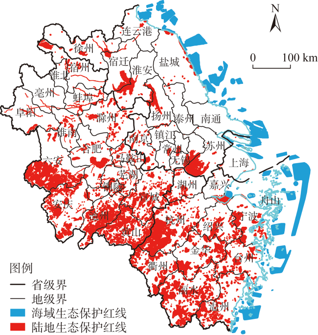
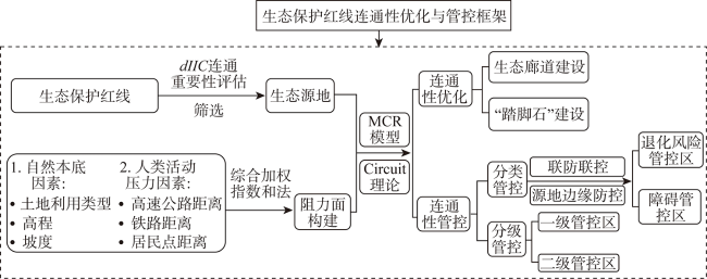
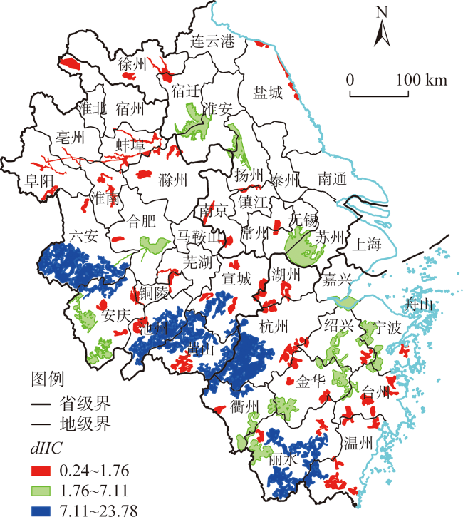
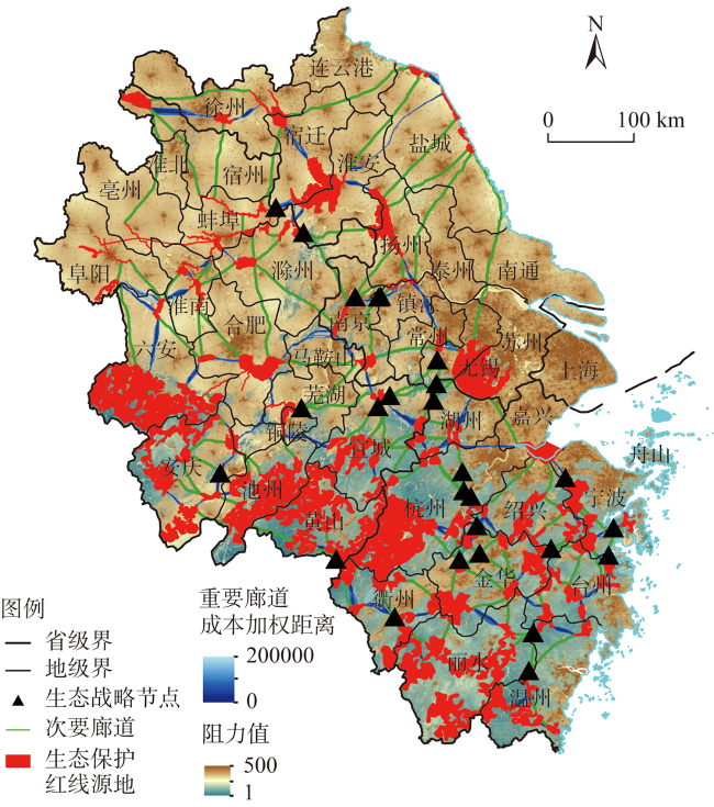
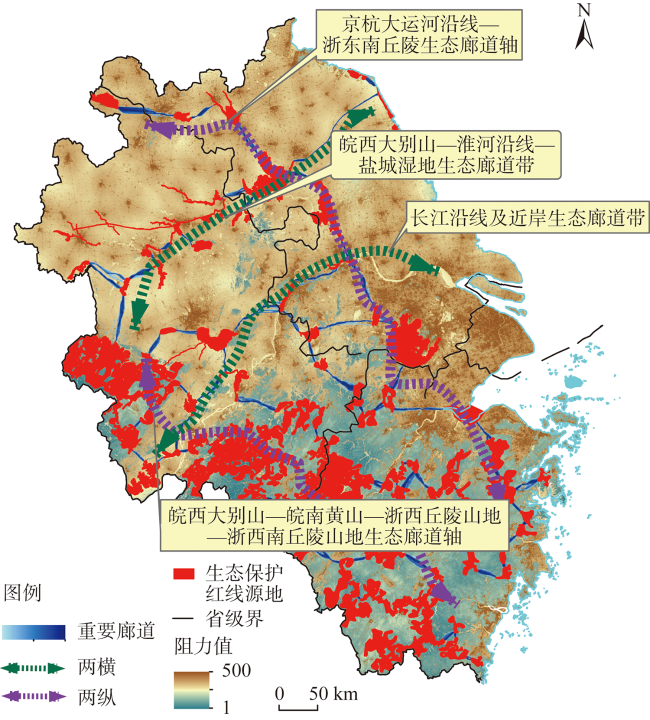
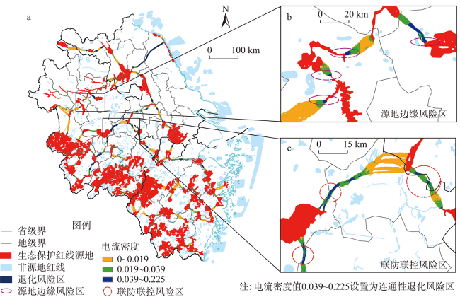
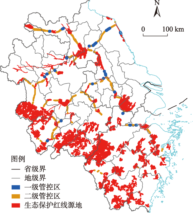
生态保护红线存在跨界冲突与破碎化等问题,目前正在不断优化、调整和评估中,但区域尺度连通性优化与管控仍然缺乏。以长三角为例,采用土地利用、道路、居民点和官方发布的生态保护红线等数据,基于最小累积阻力模型与电路理论,提出区域尺度生态保护红线连通性优化与分类分级管控方案,为长三角一体化生态共同保护提供科学依据。结果显示:(1)优化构建了长三角“两横两纵”生态廊道格局,其中包括重要廊道79条,次要廊道111条和“踏脚石”33个;(2)连通性退化风险管控区51个,其中源地边缘防控区27个,联防联控区12个;(3)障碍管控区75个,其中源地边缘防控区36个,联防联控区17个;(4)生态保护红线连通性一级管控区20个,面积为70.35 km2,二级管控区106个,面积为1511.33 km2。生态保护红线源地边缘以及省市行政边界易遭受退化风险和形成连通障碍区,建议在区域尺度上建设生态廊道和“踏脚石”,对连通性退化风险区和障碍区进行联防联控、源地边缘防控和分级防控。
马晓武 , 徐昔保 . 区域尺度生态保护红线连通性优化与管控——以长三角为例[J]. 自然资源学报, 2022 , 37(12) : 3088 -3101 . DOI: 10.31497/zrzyxb.20221205
Ecological red lines have cross-border conflicts and fragmentation, so it is constantly being optimized, adjusted and evaluated, but connectivity optimization and control at regional scale are still lacking. Taking the Yangtze River Delta as an example, based on the minimum cumulative resistance model and circuit theory, this paper proposes a region-scale connectivity optimization and control scheme of ecological red lines based on the data of land use, road settlements and officially issued ecological red lines, so as to provide a scientific basis for the integrated ecological protection of the study area. The results show that: (1) The ecological corridor pattern of "two horizontal and two vertical lines" in the Yangtze River Delta has been optimized, including 79 important corridors, 111 secondary corridors and 33 stepping stones; (2) There are 51 connectivity degradation risk control zones, including 12 joint prevention and control zones and 27 prevention and control zones at the edge of the source area; (3) There are 75 obstacle control areas, including 17 joint prevention and control areas and 36 border prevention and control areas of source areas; (4) There are 20 first-level control areas with an area of 70.35 km2, and 106 second-level control areas with an area of 1511.33 km2. The source and provincial administrative boundaries of the ecological protection red lines are vulnerable to degradation risks and connectivity barriers. Therefore, it is suggested that ecological corridors and stepping stones should be built at the regional scale, and joint prevention and control should be carried out in connectivity degradation risk areas and obstacle areas, as well as at the border of source areas, and graded prevention and control should be carried out in order of importance.
Key words: ecological red lines; ecosystem connectivity; MCR model; circuit theory
表1 连通性分级管控统计Table 1 Connectivity hierarchical control statistics |
| 管控级别 | 数量/个 | 土地利用类型面积/km2 | |||||||
|---|---|---|---|---|---|---|---|---|---|
| 耕地 | 林地 | 草地 | 湿地 | 水域 | 建筑用地 | 未利用地 | 总计 | ||
| 一级管控区 | 20 | 36.17 | 1.12 | 0.68 | 0.27 | 19.80 | 12.29 | 0.02 | 70.35 |
| 二级管控区 | 106 | 1005.29 | 119.47 | 11.84 | 4.63 | 129.48 | 237.38 | 1.97 | 1511.33 |
| 总计 | 126 | 1041.46 | 120.59 | 12.52 | 4.90 | 149.28 | 249.67 | 1.99 | 1581.68 |
| [1] |
|
| [2] |
|
| [3] |
|
| [4] |
|
| [5] |
|
| [6] |
|
| [7] |
张年国, 王娜, 殷健. 国土空间规划“三条控制线”划定的沈阳实践与优化探索. 自然资源学报, 2019, 34(10): 2175-2185.
[
|
| [8] |
易丹, 赵小敏, 郭熙, 等. 江西省“三线冲突”空间特征及其强度影响因素. 自然资源学报, 2020, 35(10): 2428-2443.
[
|
| [9] |
李怡, 赵小敏, 郭熙, 等. 基于InVEST和MCR模型的南方山地丘陵区生态保护红线优化. 自然资源学报, 2021, 36(11): 2980-2994.
[
|
| [10] |
徐昔保, 马晓武, 杨桂山. 基于生态系统完整性与连通性的生态保护红线优化探讨: 以长三角为例. 中国土地科学, 2020, 34(5): 94-103.
[
|
| [11] |
徐樑, 桑劲, 彭敏学, 等. 生态保护红线评估调整过程中的现实问题与优化建议. 城乡规划, 2020, (1): 48-57, 78.
[
|
| [12] |
方勇, 黄建洲, 罗成. 浅谈地方生态保护红线的评估问题: 以湖北黄冈市为例. 中国土地, 2020, (2): 37-39.
[
|
| [13] |
殷小勇, 叶嵩, 赵栓. 生态保护红线评估调整与管控策略研究. 中国土地, 2020, (9): 8-11.
[
|
| [14] |
严晰芹, 焦菊英, 唐柄哲, 等. 泥沙连通性研究方法进展. 泥沙研究, 2021, 46(2): 59-65.
[
|
| [15] |
|
| [16] |
欧维新, 袁薇锦. 基于景观连接度的盐城滨海湿地丹顶鹤生境斑块重要性评价. 资源科学, 2015, 37(4): 823-831.
[
|
| [17] |
王玉莹, 沈春竹, 金晓斌, 等. 基于MSPA和MCR模型的江苏省生态网络构建与优化. 生态科学, 2019, 38(2): 138-145.
[
|
| [18] |
|
| [19] |
|
| [20] |
|
| [21] |
乌建国. 景观生态学:格局过程尺度与等级. 北京: 高等教育出版社, 2007: 103-121.
[
|
| [22] |
单楠, 周可新, 潘扬, 等. 生物多样性保护廊道构建方法研究进展. 生态学报, 2019, 39(2): 411-420.
[
|
| [23] |
李久林, 徐建刚, 储金龙. 基于Circuit理论的城市生态安全格局研究: 以安庆市为例. 长江流域资源与环境, 2020, 29(8): 1812-1824.
[
|
| [24] |
梁鑫源, 金晓斌, 朱凤武, 等. 长江中下游平原区生态保护红线的划定: 以江苏省为例. 生态学报, 2020, 40(17): 5968-5979.
[
|
| [25] |
张慧. 基于生态服务功能的南京市生态安全格局研究. 南京: 南京师范大学, 2016.
[
|
| [26] |
刘佳, 尹海伟, 孔繁花, 等. 基于电路理论的南京城市绿色基础设施格局优化. 生态学报, 2018, 38(12): 4363-4372.
[
|
| [27] |
徐梦佳, 刘冬, 林乃峰, 等. 长三角一体化背景下生态保护红线的管理方向思考. 环境保护, 2020, 48(20): 16-19.
[
|
| [28] |
俞孔坚. 生物保护的景观生态安全格局. 生态学报, 1999, 19(1): 8-15.
[
|
| [29] |
|
| [30] |
宋利利, 秦明周. 整合电路理论的生态廊道及其重要性识别. 应用生态学报, 2016, 27(10): 3344-3352.
[
|
| [31] |
戴璐, 刘耀彬, 黄开忠. 基于MCR模型和DO指数的九江滨水城市生态安全网络构建. 地理学报, 2020, 75(11): 2459-2474.
[
|
| [32] |
杨姗姗, 邹长新, 沈渭寿, 等. 基于生态红线划分的生态安全格局构建: 以江西省为例. 生态学杂志, 2016, 35(1): 250-258.
[
|
| [33] |
李谦, 戴靓, 朱青, 等. 基于最小阻力模型的土地整治中生态连通性变化及其优化研究. 地理科学, 2014, 34(6): 733-739.
[
|
| [34] |
|
| [35] |
|
| [36] |
张风春, 朱留财, 彭宁. 欧盟Natura2000自然保护区的典范. 环境保护, 2011, (6): 73-74.
[
|
| [37] |
马克明, 傅伯杰, 黎晓亚, 等. 区域生态安全格局: 概念与理论基础. 生态学报, 2004, 24(4): 761-768.
[
|
| [38] |
|
| [39] |
苏冲, 董建权, 马志刚, 等. 基于生态安全格局的山水林田湖草生生态保护修复优先区识别: 以四川省华蓥山区为例. 生态学报, 2019, 39(23): 8948-8956.
[
|
| [40] |
李慧, 李丽, 吴巩胜, 等. 基于电路理论的滇金丝猴生境景观连通性分析. 生态学报, 2018, 38(6): 2221-2228.
[
|
| [41] |
方莹, 王静, 黄隆杨, 等. 基于生态安全格局的国土空间生态保护修复关键区域诊断与识别: 以烟台市为例. 自然资源学报, 2020, 35(1): 190-203.
[
|
/
| 〈 |
|
〉 |
