
东北松嫩典型黑土区长缓坡耕地土壤侵蚀沿坡长变化规律及其对土壤质量的影响
|
刘华征(1998- ),女,辽宁阜新人,博士研究生,主要从事黑土侵蚀规律研究。E-mail: huazhengliu@163.com |
收稿日期: 2021-11-22
修回日期: 2022-07-04
网络出版日期: 2022-12-28
基金资助
国家重点研发计划专项(2021YFD1500701)
国家重点研发计划战略性国际科技创新合作重点专项(2016YFE0202900)
Variation of soil erosion intensity along the long gentle farming slopes and its influence on soil quality in the typical mollisol region, Songnen Plain, Northeast China
Received date: 2021-11-22
Revised date: 2022-07-04
Online published: 2022-12-28
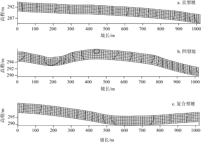
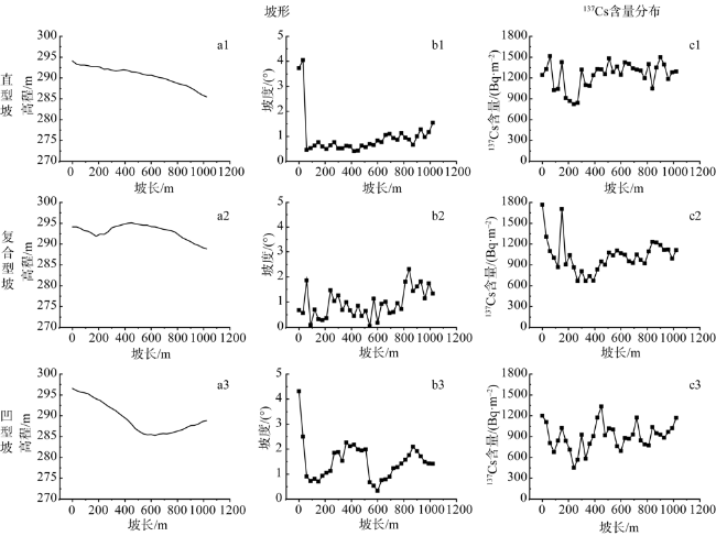
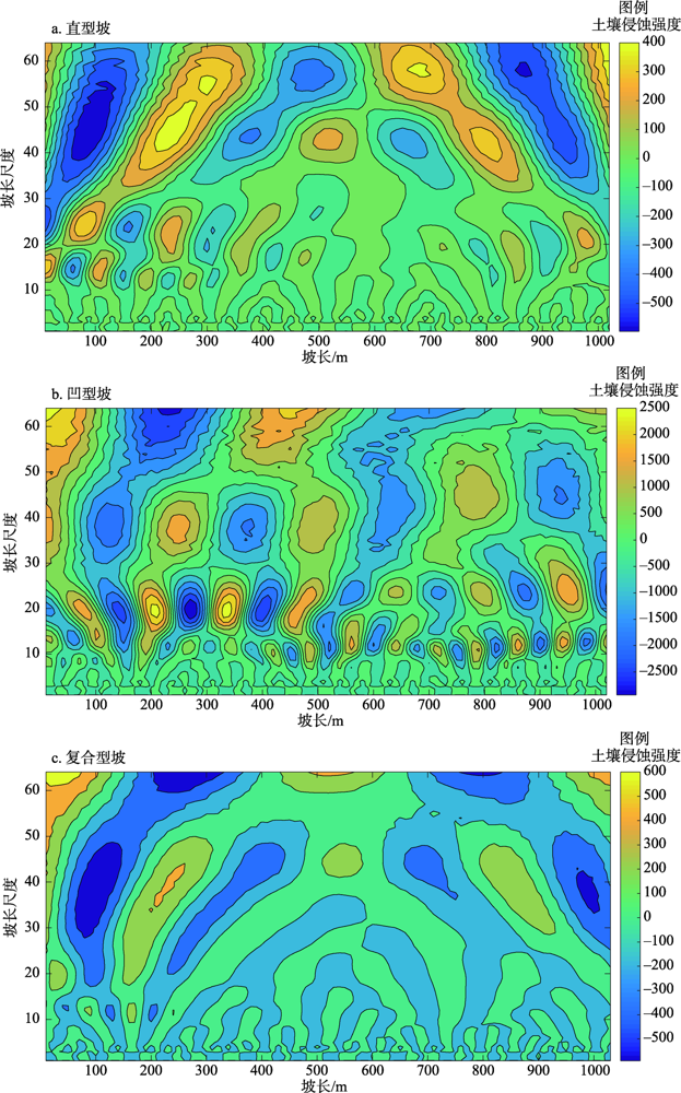
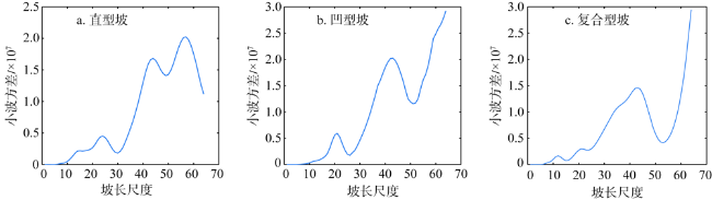
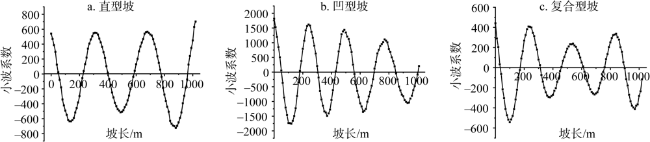
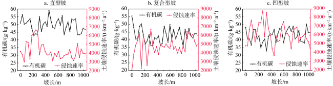
东北黑土区,尤其是农垦地区,是我国重要的粮食生产基地。土壤侵蚀导致耕地质量严重退化,威胁粮食安全。选取克山农场坡长为1020 m的直型坡、凹型坡和凹—直复合型坡耕地,利用137Cs示踪技术估算坡面土壤侵蚀模数,测定土壤有机碳作为耕地土壤质量参数,揭示典型黑土区长缓坡耕地土壤侵蚀强度沿坡长变化规律及耕地土壤质量参数的响应。结果表明:(1)不同坡形长缓坡耕地土壤侵蚀差异显著,直型坡多年平均侵蚀速率(3040 t·km-2·a-1)<复合型坡(3395 t·km-2·a-1)<凹型坡(4220 t·km-2·a-1)。(2)直型坡、凹型坡、凹—直复合型坡均呈现出侵蚀强—弱周期性变化规律,其振荡周期分别为380 m、250 m和300 m。(3)土壤有机碳含量与土壤侵蚀速率呈极显著负相关关系,其沿坡长变化规律与土壤侵蚀速率沿坡长变化规律相反。土壤侵蚀是造成黑土坡耕地土壤质量退化的直接原因,研究结果可为黑土长缓坡耕地水土保持措施的精准布设及土壤养分管理提供理论支持。
刘华征 , 贾燕锋 , 范昊明 , 王佳楠 , 韩文宁 . 东北松嫩典型黑土区长缓坡耕地土壤侵蚀沿坡长变化规律及其对土壤质量的影响[J]. 自然资源学报, 2022 , 37(9) : 2292 -2305 . DOI: 10.31497/zrzyxb.20220907
The mollisol region is one of the main grain-producing bases in China, especially the long gentle slopes. Unfortunately, more than 80% of farmland there was suffering from soil erosion, but the variation of soil erosion along the long gentle slopes was still unclear, which will make it more difficult to control soil erosion and protect soil resources. Therefore, the aim of this study was to find the variation law of soil erosion along the gentle slopes. Three gentle slopes (a straight slope, a concave slope and a compound slope ) in Keshan Farm No. 5 were selected as the objects. Soil samples were collected at 30 m intervals along the slopes in early May, 2019. Then the 137Cs-activity was measured to evaluate the soil erosion and deposition rates, and to measure soil organic carbon as a parameter of cultivated land soil quality. Wavelet analysis was employed to quantify the variation of soil erosion along the gentle slopes and the response of cultivated land soil quality parameters. The results showed that: (1) The annual average erosion rates of straight slope, composite slope and concave slope are 3040 t·km-2·a-1, 3395 t·km-2·a-1 and 4220 t·km-2·a-1, respecctively. (2) The main changing periods of the whole straight gentle slope, the concave gentle slope, and the compound gentle slope were 380 m, 250 m, and 300 m, respectively. (3) There was a significant negative correlation between soil SOC content and soil erosion rate, and the spatial distribution of soil SOC along the slope length was opposite to that of soil erosion rate, indicating that soil erosion is a key driving factor for soil degradation. Conclusions of this study can help to formulate the targeted soil and water conservation measures for the realization of soil nutrient management along long gentle slope and provides theoretical guidance for soil erosion control of the long gentle cultivated slopes in the mollisol region of Northeast China.
表1 采样点137Cs面积活度Table 1 Inventories of 137Cs at sampling points |
| 采样地点 | 样点数/个 | 面积活度/(Bq·m-2) | 变异系数 /% | ||
|---|---|---|---|---|---|
| 最大值 | 最小值 | 平均值 | |||
| 直型坡 | 34 | 1514.7b | 821.7a | 1242.6 186.2a | 14 |
| 凹型坡 | 34 | 1201.2c | 448.8c | 901.5 192.3c | 21 |
| 复合型坡 | 34 | 1765.5a | 669.9b | 1028.5 233.0b | 22 |
注:同列不同字母表示显著性差异(P≤0.01)。 |
表2 东北黑土区坡耕地侵蚀规律研究Table 2 Study on erosion law of slope farmland in black soil area of Northeast China |
表3 137Cs测量土壤再分配评估Table 3 Evaluation of 137Cs measurement of soil redistribution |
| 侵蚀点数量/个 | 沉积点数量/个 | 侵蚀速率/(t·km-2·a-1) | 输沙率/% | |||
|---|---|---|---|---|---|---|
| 平均值 | 最大值 | 最小值 | ||||
| 直型坡 | 34 | 0 | 3040±152 | 4710 | 2070 | 100 |
| 凹型坡 | 34 | 0 | 4220±210 | 7240 | 2350 | 100 |
| 复合型坡 | 34 | 0 | 3395±202 | 5090 | 1220 | 100 |
| [1] |
水利部, 中国科学院, 中国工程院. 中国水土流失与生态安全:东北黑土卷. 北京: 科学出版社, 2010.
[Ministry of Water Resources, Chinese Academy of Sciences, Chinese Academy of Engineering. Soil Erosion Control and Ecological Security in China Black Soil Region of Northeast China Volume. Beijing: Science Press, 2010.]
|
| [2] |
|
| [3] |
金平华, 濮励杰, 王金磊, 等. 137Cs法用于典型流域土壤侵蚀的初步研究: 以太湖流域上游西苕溪流域为例. 自然资源学报, 2004, 19(1): 47-54.
[
|
| [4] |
|
| [5] |
付兴涛, 张丽萍, 叶碎高. 经济林地坡长对侵蚀产沙动态过程影响的模拟. 水土保持学报, 2010, 24(4): 73-77.
[
|
| [6] |
刘冉, 余新晓, 蔡强国, 等. 坡长对坡面侵蚀、搬运、沉积过程影响的研究进展. 中国水土保持科学, 2020, 18(6): 140-146.
[
|
| [7] |
|
| [8] |
|
| [9] |
魏天兴, 朱金兆. 黄土残塬沟壑区坡度和坡长对土壤侵蚀的影响分析. 北京林业大学学报, 2002, 24(1): 59-62.
[
|
| [10] |
王颢霖, 焦菊英, 唐柄哲, 等. 陕北子洲“7·26”暴雨后坡耕地细沟侵蚀及其影响因素分析. 农业工程学报, 2019, 35(11): 122-130.
[
|
| [11] |
王禹, 杨明义, 刘普灵. 典型黑土直型坡耕地土壤侵蚀强度的小波分析. 核农学报, 2010, 24(4): 790-795.
[
|
| [12] |
杨维鸽, 郑粉莉, 王占礼, 等. 地形对黑土区典型坡面侵蚀—沉积空间分布特征的影响. 土壤学报, 2016, 53(3): 572-581.
[
|
| [13] |
李骜, 段兴武. 利用黑土层厚度评价东北黑土区土壤生产力: 以鹤北小流域为例. 水土保持通报, 2014, 34(1): 154-159.
[
|
| [14] |
|
| [15] |
|
| [16] |
|
| [17] |
|
| [18] |
|
| [19] |
|
| [20] |
|
| [21] |
翟星雨. 典型黑土坡面农田有机质和全氮的时空分布研究. 哈尔滨: 东北农业大学, 2019.
[
|
| [22] |
方华军, 杨学明, 张晓平, 等. 137Cs示踪技术研究坡耕地黑土侵蚀和沉积特征. 生态学报, 2005, 25(6): 1376-1382.
[
|
| [23] |
|
| [24] |
方华军, 杨学明, 张晓平, 等. 利用137Cs 技术研究黑土坡耕地土壤再分布特征. 应用生态学报, 2005, 16(3): 464-468
[
|
| [25] |
何彦星, 张风宝, 杨明义. 137Cs示踪分析东北黑土坡耕地土壤侵蚀对有机碳组分的影响. 农业工程学报, 2021, 37(14): 60-68.
[
|
| [26] |
|
| [27] |
|
| [28] |
王小康, 谷举, 刘刚, 等. 横、顺坡垄作对黑土坡面侵蚀—沉积周期规律的影响. 土壤学报, 2022, 59(2): 430-439.
[
|
| [29] |
|
| [30] |
|
| [31] |
|
| [32] |
|
| [33] |
|
| [34] |
阎百兴, 汤洁. 黑土侵蚀速率及其对土壤质量的影响. 地理研究, 2005, 24(4): 499-506.
[
|
| [35] |
|
| [36] |
|
| [37] |
|
| [38] |
钟科元, 郑粉莉. 1960—2014年松花江流域降雨侵蚀力时空变化研究. 自然资源学报, 2017, 32(2): 78-291.
[
|
| [39] |
武春龙, 刘普灵, 郑世清, 等. 坡面土壤侵蚀垂直分布定量分析研究. 水土保持研究, 1997, 4(2): 34-40.
[
|
| [40] |
张宪奎, 许靖华, 卢秀琴, 等. 黑龙江省土壤流失方程的研究. 水土保持通报, 1992, 12(4): 1-9.
[
|
| [41] |
|
| [42] |
郑粉莉, 边锋, 卢嘉, 等. 雨型对东北典型黑土区顺坡垄作坡面土壤侵蚀的影响. 农业机械学报, 2016, 45(2): 90-97.
[
|
| [43] |
|
| [44] |
|
| [45] |
|
| [46] |
许炯心. 黄土高原丘陵沟壑区坡面—沟道系统中的高含沙水流(Ⅱ). 自然灾害学报, 2004, 13(2): 25-31.
[
|
| [47] |
|
| [48] |
|
/
| 〈 |
|
〉 |