
东北黑土区典型地域耕地生态退化时空分异——以富锦市为例
|
隋虹均(1994- ),男,黑龙江齐齐哈尔人,博士研究生,研究方向为土地利用与管理。E-mail: suihongjun0206@163.com |
收稿日期: 2022-05-09
修回日期: 2022-07-11
网络出版日期: 2022-12-28
基金资助
国家自然科学基金项目(41971247)
国家自然科学基金项目(42101254)
Spatio-temporal differentiation of cultivated land ecological degradation in typical black soil regions of Northeast China: A case study of Fujin city
Received date: 2022-05-09
Revised date: 2022-07-11
Online published: 2022-12-28
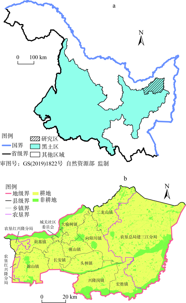
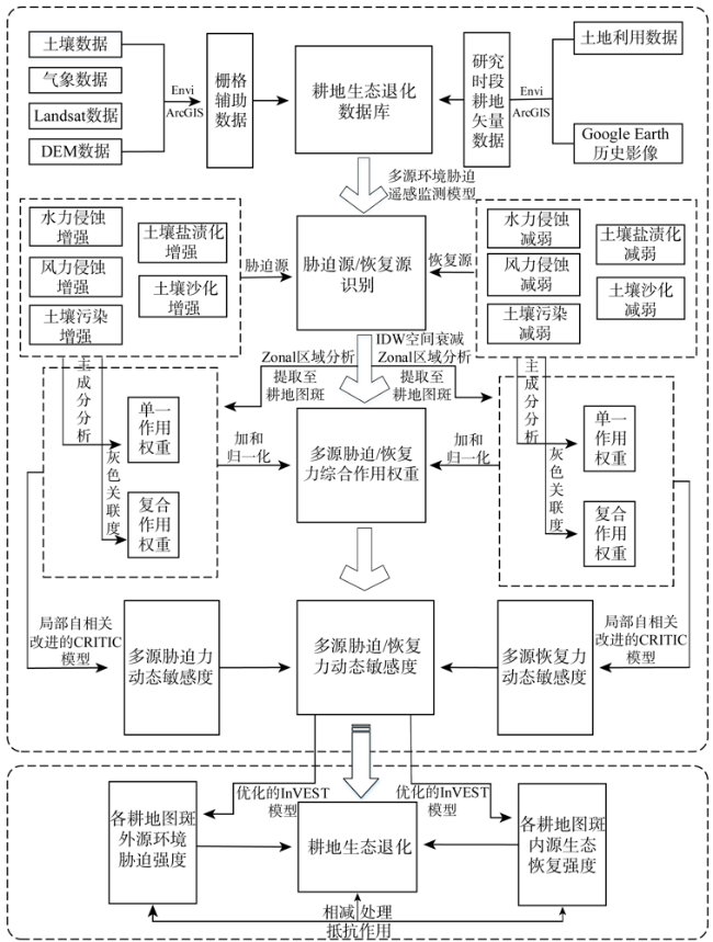
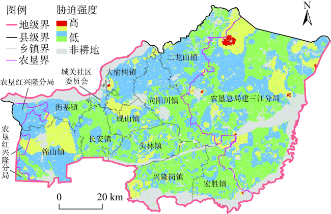
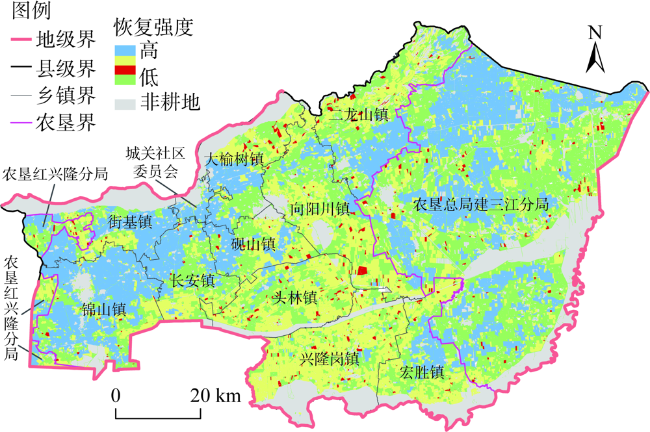
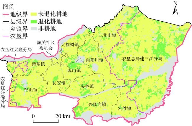
耕地生态退化严重威胁黑土区耕地的可持续利用,明确其时空分异规律是提高黑土耕地产能实现农业可持续发展的重要科学命题。以东北黑土区典型地域富锦市为研究区,立足于耕地外部扰动变化所引发的环境胁迫与生态恢复,利用遥感驱动的多源环境胁迫监测模型、改进的CRITIC模型、优化的InVEST模型,明确二者间的作用结果,揭示研究区2000—2020年耕地生态退化的时空分异规律。研究结果表明:(1)研究区耕地外源环境胁迫强度整体偏低,呈现出以东部、西部、北部高,中部、南部低为主基调的时空分异格局;(2)研究区耕地內源生态恢复强度高于胁迫强度,表现出以西部—东部—中部梯度衰减的时空分异格局;(3)研究区共有968.12 km2耕地发生生态退化,展现出以团块状集中分布在研究区东部和中部,零星分布在其他区域的空间分异格局。研究明晰了多源环境胁迫/多源生态恢复之间的交互效应,实现了各耕地图斑对多种环境胁迫力和生态恢复力的动态敏感度测算,进一步刻画出了生态退化过程,测度结果与现实耕地利用强度吻合,为准确诊断黑土区耕地生态退化提供了理论参考和技术支撑。
隋虹均 , 宋戈 , 高佳 . 东北黑土区典型地域耕地生态退化时空分异——以富锦市为例[J]. 自然资源学报, 2022 , 37(9) : 2277 -2291 . DOI: 10.31497/zrzyxb.20220906
The ecological degradation of cultivated land poses a serious threat to the sustainable development of black soil regions. Clarifying the law of the spatial and temporal differentiation is an important scientific proposition to improve the productivity of black soil cultivated land and achieve sustainable agricultural development. Taking Fujin, a typical city of black soil in Northeast China as the research area, based on the environmental stress and ecological restoration caused by external disturbance changes in cultivated land, the remote sensing-driven multi-source environmental stress monitoring model, the improved CRITIC model, and the optimized InVEST model are used to clarify the results of the interaction between the environmental stress and ecological restoration, revealing the spatio-temporal differentiation of the ecological degradation of cultivated land in the study area from 2000 to 2020. Results showed that: (1) The exogenous environmental stress intensity of cultivated land is overall low, showing a spatial and temporal differentiation pattern with the intensity being high in the east, west, and north, while low in the middle and south. (2) The endogenous ecological restoration intensity of the cultivated land is higher than the stress intensity, showing a spatial and temporal differentiation pattern with a west-east-central gradient attenuation. (3) A total of 968.12 km2 of cultivated land has experienced ecological degradation, which is concentrated in the eastern and central parts of the study area and sporadically distributed in other parts. The study clarified the interaction effect between multi-source environmental stress and multi-source ecological restoration, realized the dynamic sensitivity measurement of each cultivated land plot to various environmental stresses and ecological resilience, and further characterized the ecological degradation process and the measurement results, which is consistent with the actual cultivated land use intensity. The results provide theoretical reference and technical support for the accurate diagnosis of ecologically degraded cultivated land in black soil regions.
表1 耕地外源环境胁迫权重与内源生态恢复权重Table 1 The weight of exogenous environmental stress and endogenous ecological restoration weight of cultivated land |
| 胁迫/恢复指标 | 外源环境胁迫权重 | 内源生态恢复权重 | |||||
|---|---|---|---|---|---|---|---|
| 单一权重 | 复合权重 | 综合权重 | 单一权重 | 复合权重 | 综合权重 | ||
| 水力侵蚀 | 0.1242 | 0.0249 | 0.0746 | 0.1065 | 0.0112 | 0.0588 | |
| 风力侵蚀 | 0.1351 | 0.0571 | 0.0961 | 0.1111 | 0.0296 | 0.0704 | |
| 土壤污染 | 0.2372 | 0.2692 | 0.2532 | 0.2432 | 0.2636 | 0.2534 | |
| 土壤盐渍化 | 0.2531 | 0.3294 | 0.2912 | 0.2707 | 0.3503 | 0.3105 | |
| 土地沙化 | 0.2504 | 0.3194 | 0.2849 | 0.2685 | 0.3453 | 0.3069 | |
| [1] |
张佳宝, 孙波, 朱教君, 等. 黑土地保护利用与山水林田湖草沙系统的协调及生态屏障建设战略. 中国科学院院刊, 2021, 36(10): 1155-1164.
[
|
| [2] |
韩晓增, 李娜. 中国东北黑土地研究进展与展望. 地理科学, 2018, 38(7): 1032-1041.
[
|
| [3] |
汪景宽, 徐香茹, 裴久渤, 等. 东北黑土地区耕地质量现状与面临的机遇和挑战. 土壤通报, 2021, 52(3): 695-701.
[
|
| [4] |
王志刚. 充分发挥科技创新在保护利用黑土地中的关键支撑作用. 中国科学院院刊, 2021, 36(10): 1127-1132.
[
|
| [5] |
韩晓增, 邹文秀. 东北黑土地保护利用研究足迹与科技研发展望. 土壤学报, 2021, 58(6): 1341-1358.
[
|
| [6] |
中国科学院. 东北黑土地白皮书(2020), https://www.cas.cn/yw/202107/W020210714418584895253.pdf.
[Chinese Academy of Sciences. Northeast black land white paper(2020), https://www.cas.cn/yw/202107/W020210714418584895253.pdf.]
|
| [7] |
任海, 刘庆, 李凌浩, 等. 恢复生态学导论. 北京: 科学出版社, 2019: 84.
[
|
| [8] |
孔祥斌. 中国耕地保护生态治理内涵及实现路径. 中国土地科学, 2020, 34(12): 1-10.
[
|
| [9] |
孔祥斌. “休养生息”意在提质增效. 国土资源, 2016, (2): 9.
[
|
| [10] |
孙武, 李森. 土地退化评价与监测技术路线的研究. 地理科学, 2000, 20(1): 92-96.
[
|
| [11] |
罗明, 龙花楼. 土地退化研究综述. 生态环境, 2005, 14(2): 287-293.
[
|
| [12] |
彭双云, 杨昆, 洪亮, 等. 基于USLE模型的滇池流域土壤侵蚀时空演变分析. 农业工程学报, 2018, 34(10): 138-146, 305.
[
|
| [13] |
邢丽珠, 张方敏, 邢开成, 等. 基于RWEQ模型的内蒙古巴彦淖尔市土壤风蚀变化特征及归因分析. 中国沙漠, 2021, 41(5): 111-119.
[
|
| [14] |
王盼盼, 宋戈. 1979—2015年松嫩高平原土地利用格局变化及影响因子分析. 农业工程学报, 2018, 34(2): 256-264.
[
|
| [15] |
王飞, 丁建丽, 伍漫春. 基于NDVI-SI特征空间的土壤盐渍化遥感模型. 农业工程学报, 2010, 26(8): 168-173, 8.
[
|
| [16] |
曾永年, 向南平, 冯兆东, 等. Albedo-NDVI特征空间及沙漠化遥感监测指数研究. 地理科学, 2006, 26(1): 75-81.
[
|
| [17] |
|
| [18] |
卞正富, 于昊辰, 侯竟, 等. 西部重点煤矿区土地退化的影响因素及其评估. 煤炭学报, 2020, 45(1): 338-350.
[
|
| [19] |
李怡, 赵小敏, 郭熙, 等. 基于InVEST和MCR模型的南方山地丘陵区生态保护红线优化. 自然资源学报, 2021, 36(11): 2980-2994.
[
|
| [20] |
刘宝元, 张甘霖, 谢云, 等. 东北黑土区和东北典型黑土区的范围与划界. 中国科学通报, 2021, 66(1): 96-106.
[
|
| [21] |
张宪奎, 许靖华, 卢秀琴, 等. 黑龙江省土壤流失方程的研究. 水土保持通报, 1992, 12(4): 1-9, 18.
[
|
| [22] |
张彪, 李庆旭, 王爽, 等. 京津风沙源区防风固沙功能的时空变化及其区域差异. 自然资源学报, 2019, 34(5): 1041-1053.
[
|
| [23] |
杜国明, 刘文琦, 于佳兴, 等. 三江平原水旱田分布对遥感反演局地地表温度的影响. 农业工程学报, 2019, 35(5): 259-267, 320.
[
|
| [24] |
丁一汇, 李霄, 李巧萍. 气候变暖背景下中国地面风速变化研究进展. 应用气象学报, 2020, 31(1): 1-12.
[
|
/
| 〈 |
|
〉 |