
基于生态系统服务的海洋空间开发适宜性评价方法及应用——以粤港澳大湾区伶仃洋为例
|
李杨帆(1978- ),男,山西洪洞人,博士,教授,博士生导师,主要从事海岸带陆海统筹与可持续发展方面研究。E-mail: yangf@xmu.edu.cn |
收稿日期: 2021-09-02
要求修回日期: 2021-11-25
网络出版日期: 2022-06-28
基金资助
南方海洋科学与工程广东省实验室(珠海)创新团队项目(311021004)
国家自然科学基金项目(41976208)
版权
Evaluation of marine space development suitability based on ecosystem service: A case study of Lingdingyang Bay of Guangdong-Hong Kong-Macao Greater Bay Area
Received date: 2021-09-02
Request revised date: 2021-11-25
Online published: 2022-06-28
Copyright
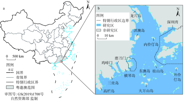
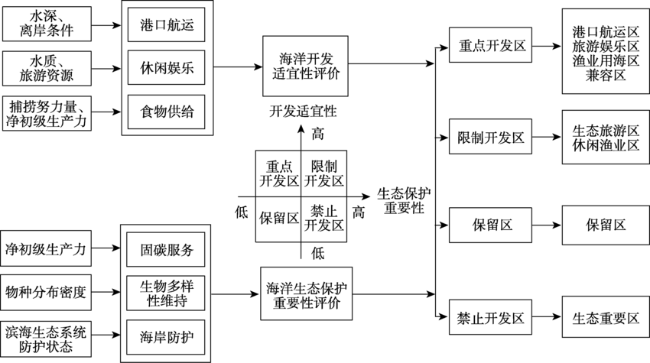
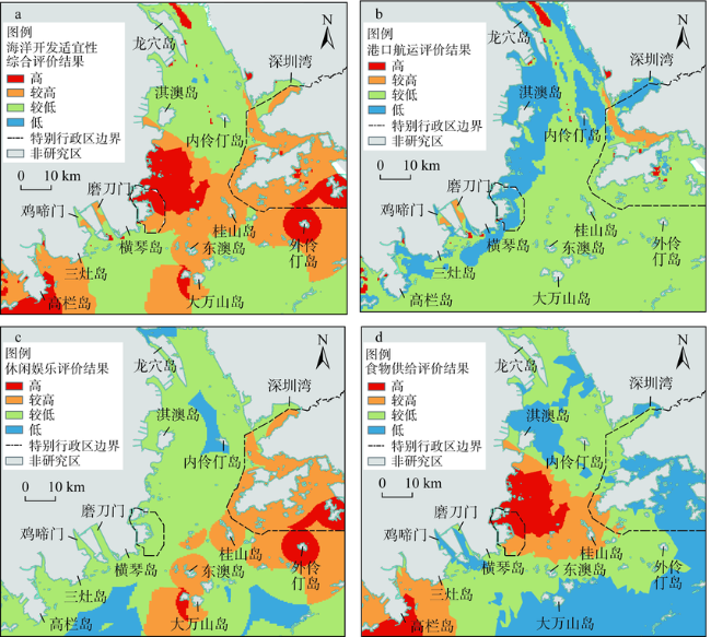
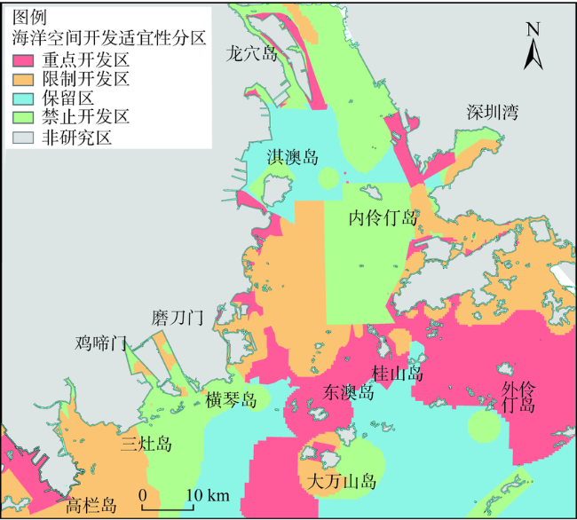
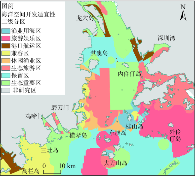
海洋空间开发适宜性评价是开展海洋空间规划的基础,对粤港澳大湾区协同发展具有重要意义。在生态系统服务框架下提出伶仃洋空间开发适宜性评价方法并分区。根据一级分区结果、开发适宜性—生态保护重要性矩阵和面积占比,分为重点开发区(高—低,30.63%)、限制开发区(高—高,22.71%)、保留区(低—低,23.37%)、禁止开发区(低—高,23.29%),以上四区开发适宜性依次递减。根据资源禀赋和用海兼容条件进行二级分区,重点开发区包括港口航运、旅游、渔业等单功能二级区(近岸与岛屿周围海域)和兼容二级区(桂山岛外围海域),关注供给/文化服务协同开发。限制开发区分为生态旅游和休闲渔业二级区,分布于香港、澳门地区近岸海域,需权衡供给/文化服务的开发和调节/支持服务的保护。
李杨帆 , 张倩 , 向枝远 , 张振 . 基于生态系统服务的海洋空间开发适宜性评价方法及应用——以粤港澳大湾区伶仃洋为例[J]. 自然资源学报, 2022 , 37(4) : 999 -1009 . DOI: 10.31497/zrzyxb.20220411
The evaluation of marine space development suitability, an important part of marine spatial planning, is of great significance to the implementation of a coordinated development strategy in the Guangdong-Hong Kong-Macao Greater Bay Area. We developed a methodology to evaluate marine space development suitability based on ecosystem service. Lingdingyang Bay is divided into key development zones, restricted development zones, prohibited development zones and reserved zones, in a descending order of marine space development suitability, which account for 30.63%, 22.71%, 23.37% and 23.29%, respectively. The relationship between development suitability and ecological protection importance of these four zones are high-low, high-high, low-low, and low-high, respectively. According to the resource endowment and sea compatibility conditions, we divide key development zones into single-function zones and compatible zones. Single-function zones, located in nearshore and sea areas around the islands, are accessible separately to port shipping, tourism and fishery activity, while compatible zones, located around Guishan Island, focus mainly on the synergy of supply and cultural services. Restricted development zones include ecological tourism zones and recreational fisheries zones, which are distributed in the coastal waters of Hong Kong and Macao, focusing on the tradeoff between the development of supply/cultural services and the protection of regulation/support services.
表1 数据来源Table 1 Data sources |
| 主要数据 | 年份 | 空间分辨率/m | 数据来源 | 数据源说明 |
|---|---|---|---|---|
| 兴趣点数据 | 2020 | — | http://www.resdc.cn/data.aspx?DATAID=341 | 包含地理空间位置和地理要素属性信息的点状数据,具有信息量大、准确性高和动态性强的特点,包括餐饮服务、风景名胜、交通基础设施、住宿等25类 |
| MODIS三级遥感产品数据 | 2018 | 4000 | http://oceancolor.gsfc.nasa.gov | 主要包括叶绿素a浓度数据、海水表面温度数据、光合有效辐射强度数据、海水漫衰减系数 |
| 渔业捕捞努力量 | 2018 | 1000 | https://globalfishingwatch.org/ | 基于高分辨率的船舶AIS数据反演的捕捞小时数数据 |
| 海洋物种分布 数据 | 2020 | — | https://www.gbif.org/ | 包含动物、植物、真菌、细菌、原生动物、原藻、病毒、古生菌等不同物种的出现记录 |
| 海岸线数据 | 2020 | — | https://osmdata.openstreetmap.de/ | 包含海岸线、陆地多边形、海洋多边形 |
| 水深数据 | 2020 | 1000 | https://www.gebco.net/ | 数字高程数据 |
| 盐沼分布数据 | 2020 | 30 | 遥感解译 | — |
| 红树林分布数据 | 2020 | 30 | 遥感解译 | — |
| 广东省水质数据 | 2020 | — | 2020年广东省生态环境状况公报 | 点位数据 |
| 香港水质数据 | 2020 | — | 2020年香港水质报告 | 点位数据 |
| 香港保护区分布数据 | 2020 | — | http://www.afcd.gov.hk | 分为核心区和外围区,核心区用于保护具有高生态价值的海洋生物,禁止捕鱼活动 |
| 澳门保护区分布数据 | 2020 | — | https://www.openstreetmap.org/#map=15/22.1334/113.5544 | 分为生态一区(封闭式管理)和生态二区(开放式管理) |
表2 伶仃洋海洋空间开发适宜性二级分区统计Table 2 Zoning statistics of marine space development suitability |
| 分区 | 二级分区 | 面积/km2 | 比例/% |
|---|---|---|---|
| 重点开发区 | 港口航运区 | 327.34 | 5.04 |
| 旅游娱乐区 | 998.5 | 15.37 | |
| 渔业用海区 | 318.84 | 4.91 | |
| 兼容区 | 345.03 | 5.31 | |
| 限制开发区 | 生态旅游区 | 1001.85 | 15.42 |
| 休闲渔业区 | 473.10 | 7.28 | |
| 保留区 | 保留区 | 1513.11 | 23.29 |
| 禁止开发区 | 生态重要区 | 1518.04 | 23.37 |
| 合计 | 6495.81 | 100.00 |
| [1] |
王金华, 黄华梅, 贾后磊, 等. 粤港澳大湾区海岸带生态系统保护和修复策略. 生态学报, 2020, 40(23):8430-8439.
[
|
| [2] |
中华人民共和国自然资源部. 资源环境承载能力和国土空间开发适宜性评价指南(试行). http://gi.mnr.gov.cn/202001/P020200121501685759831.pdf, 2020-01-19.
[Ministry of Natural Resources of the PRC. Guideline on the evaluation of resources and environment carrying capacity and territorial development suitability (trial guide). http://gi.mnr.gov.cn/202001/P020200121501685759831.pdf, 2020-01-19.]
|
| [3] |
王雨薇, 蔚芳, 周轶男, 等. 空间规划中生态系统服务评估方法研究. 城市发展研究, 2021, 28(5):19-27, 59.
[
|
| [4] |
钟镇涛, 张鸿辉, 洪良, 等. 生态文明视角下的国土空间底线管控: “双评价”与国土空间规划监测评估预警. 自然资源学报, 2020, 35(10):2415-2427.
[
|
| [5] |
|
| [6] |
|
| [7] |
冯友建, 郑增凯. 宁波市旅游娱乐用海适宜性评价和海洋功能区划完善研究. 海洋开发与管理, 2017, 34(8):92-96.
[
|
| [8] |
岳文泽, 吴桐, 王田雨, 等. 面向国土空间规划的“双评价”: 挑战与应对. 自然资源学报, 2020, 35(10):2299-2310.
[
|
| [9] |
Millennium Ecosystem Assessment (MEA). Ecosystems and Human Well-being: Current State and Trends. Washington DC: Island Press, 2005.
|
| [10] |
|
| [11] |
|
| [12] |
|
| [13] |
胡文佳, 陈彬, 马志远, 等. 基于生态系统的海洋空间规划: 研究进展与启示. 海洋开发与管理, 2020, 37(4):3-11.
[
|
| [14] |
赵玉灵. 近40年来伶仃洋海岸线与红树林遥感调查与演变分析. 国土资源遥感, 2017, 29(1):136-142.
[
|
| [15] |
|
| [16] |
阳立军, 顾波军, 管林挺. 舟山群岛港口岸线资源综合评价及优化利用研究. 资源科学, 2012, 34(11):2206-2213.
[
|
| [17] |
柯志新, 陈丹婷, 谭烨辉, 等. 汕头南澳—东山海域初级生产力的时空特征. 中国水产科学, 2019, 26(1):44-52.
[
|
| [18] |
李婷, 赵嵩玲, 田园园, 等. 基于净初级生产力的东南太平洋茎柔鱼资源变动研究. 海洋渔业, 2020, 42(5):513-523.
[
|
| [19] |
|
| [20] |
熊善高, 秦昌波, 于雷, 等. 基于生态系统服务功能和生态敏感性的生态空间划定研究: 以南宁市为例. 生态学报, 2018, 38(22) : 7899-7911.
[
|
| [21] |
石洪华, 王晓丽, 郑伟, 等. 海洋生态系统固碳能力估算方法研究进展. 生态学报, 2014, 34(1):12-22.
[
|
| [22] |
|
| [23] |
|
| [24] |
|
/
| 〈 |
|
〉 |
