
流域和河口高强度人类活动对崇明岛滩涂资源变化过程的影响
|
马彬彬(1993- ),男,江苏如皋人,博士研究生,研究方向为海岸带资源开发与管理。E-mail: mbb_ecnu@163.com |
收稿日期: 2020-09-07
要求修回日期: 2021-08-09
网络出版日期: 2022-06-28
基金资助
上海市国际科技合作基金项目(19230712400)
国家自然科学基金委—中华人民共和国水利部—中国长江三峡集团有限公司长江水科学研究联合基金项目(U2040202)
国家自然科学基金项目(42076174)
版权
Study on the influence of intensive human activities on the variation process of tidal flat resources in Chongming Island
Received date: 2020-09-07
Request revised date: 2021-08-09
Online published: 2022-06-28
Copyright
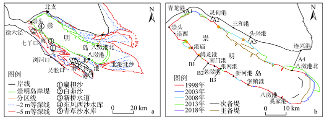
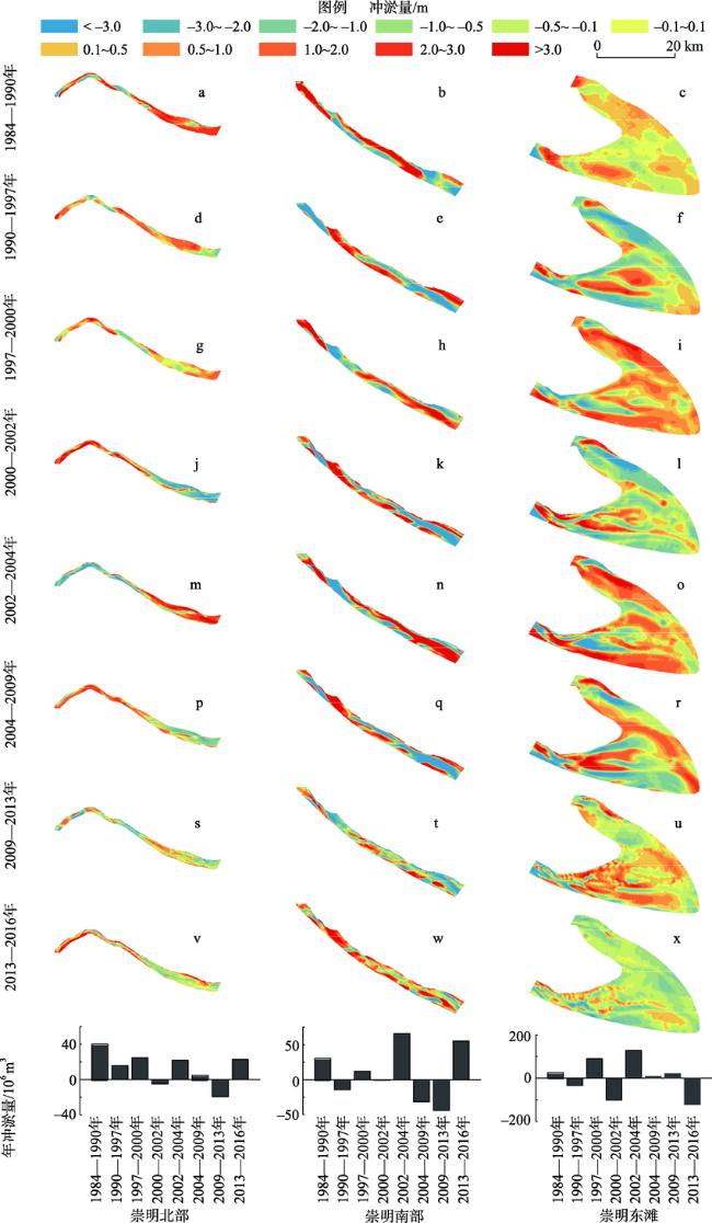
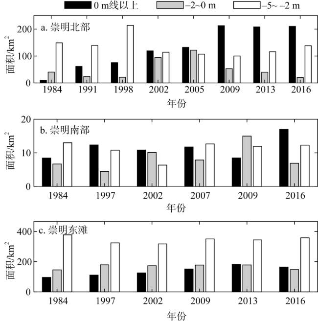
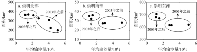
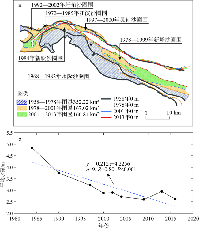
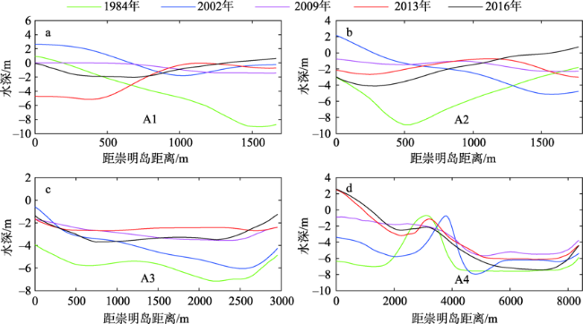
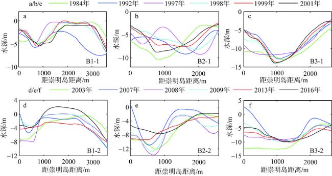
入海河口形成的冲积沙岛滩涂因陆海水沙变异而出现快速冲淤已成为当前河口城市发展关注的焦点。崇明岛为我国最大的入海河口冲积沙岛,其滩涂给上海提供极其重要的空间资源,但因流域和河口高强度人类活动可能导致滩涂出现新的变化状态。据此,通过长达30多年的环岛实测地形资料,基于ArcGIS平台摸清崇明岛滩涂资源变化过程及主控要素。研究结论主要包括:(1)崇明岛各段滩涂冲淤过程复杂多变,冲淤交替频繁;但总体上北部、南部和东滩滩涂面积均为正增长,分别增加170 km2、8 km2和51 km2。(2)促淤圈围工程导致北支泥沙量增多加速河槽萎缩淤积,是北部滩涂增长的主因。(3)新桥水道北移且有所淤浅导致南部滩涂面积淤涨,而东滩快速围垦及岸堤向海推进引起东滩滩涂面积扩大。
马彬彬 , 何钰滢 , 戴志军 . 流域和河口高强度人类活动对崇明岛滩涂资源变化过程的影响[J]. 自然资源学报, 2022 , 37(4) : 1025 -1035 . DOI: 10.31497/zrzyxb.20220413
The rapid erosion and deposition of tidal flat in alluvial island in estuaries due to the variations of land-sea sediments discharge has become the focus of urban development. Chongming Island, the largest alluvial island in China, has become an extremely valuable reserve land resource in Shanghai. However, the tidal resource in this island possibly presented new variation due to intensive human activities in drainage basins and estuaries. Accordingly, based on topographic data and measured bathymetric data around Chongming Island from 1984 to 2016, we illustrated the variation process of tidal flats in the study area through ArcGIS analysis and mathematical statistical analysis, and discussed the main factors influencing the geomorphic evolution of tidal flats. The results mainly include: (1) The process of erosion and accretion in each section of tidal flat around Chongming Island was complicated and varied. Totally, during the past three decades, the areas of the northern, southern and eastern beaches increased by 170 km2, 8 km2 and 51 km2, respectively. (2) Variation of the northern tidal flat was affected by land reclamation, which led to the shrinkage of the north branch and promoted the continuous growth of the tidal flat. (3) The deposition of Xinqiao channel and its northward movement to the island directly caused the expansion of the southern tidal flat. The eastern tidal flat was dominated by frequent reclamation projects. Owing to the continuous outward movement of the embankment, the tidal flat expanded greatly in the past decades.
表1 数据收集及来源Table 1 Data collection and sources |
| 测量年份 | 区域 | 数据来源 |
|---|---|---|
| 1984, 1990, 1997, 2000, 2002, 2004, 2009, 2013, 2016 | 环崇明岛 | 上海海事局 |
| 1991, 1998, 2005 | 北支 | 长江口航道管理局 |
| 1992, 1998, 1999, 2001, 2003, 2007, 2008 | 南支 | 上海河口海岸研究中心 |
| [1] |
陈吉余. 中国河口海岸研究与实践. 北京: 高等教育出版社, 2007: 18-22.
[
|
| [2] |
|
| [3] |
|
| [4] |
|
| [5] |
|
| [6] |
|
| [7] |
|
| [8] |
|
| [9] |
朱庆光, 冯振兴, 徐夏楠, 等. 围垦工程影响下的江苏弶港潮滩剖面的演化机制. 海洋地质与第四纪地质, 2014, 34(3):21-29.
[
|
| [10] |
|
| [11] |
|
| [12] |
韩震, 恽才兴, 戴志军, 等. 淤泥质潮滩高程及冲淤变化遥感定量反演方法研究: 以长江口崇明东滩为例. 海洋湖沼通报, 2009, (1):12-18.
[
|
| [13] |
陈中原. 长江河流入海泥沙通量的探讨. 海洋地质与第四纪地质, 2007, 27(1):1-5.
[
|
| [14] |
|
| [15] |
|
| [16] |
魏嵩山. 崇明岛的形成、演变及其开发的历史过程. 学术月刊, 1983, (4):74-77.
[
|
| [17] |
冯凌旋, 李九发, 戴志军, 等. 近年来长江河口北支水沙特性与河槽稳定性分析. 海洋学研究, 2009, 27(3):40-47.
[
|
| [18] |
恽才兴. 图说长江河口演变. 北京: 海洋出版社, 2010.
[
|
| [19] |
茅志昌, 虞志英, 徐海根. 上海潮滩研究. 上海: 华东师范大学出版社, 2014.
[
|
| [20] |
姚弘毅, 李九发, 戴志军, 等. 长江河口北港河道泥沙特性及河床沙再悬浮研究. 泥沙研究, 2013, (3):6-13.
[
|
| [21] |
|
| [22] |
路兵, 蒋雪中. 滩涂围垦对崇明东滩演化影响的遥感研究. 遥感学报, 2013, 17(2):342-349.
[
|
| [23] |
|
/
| 〈 |
|
〉 |