
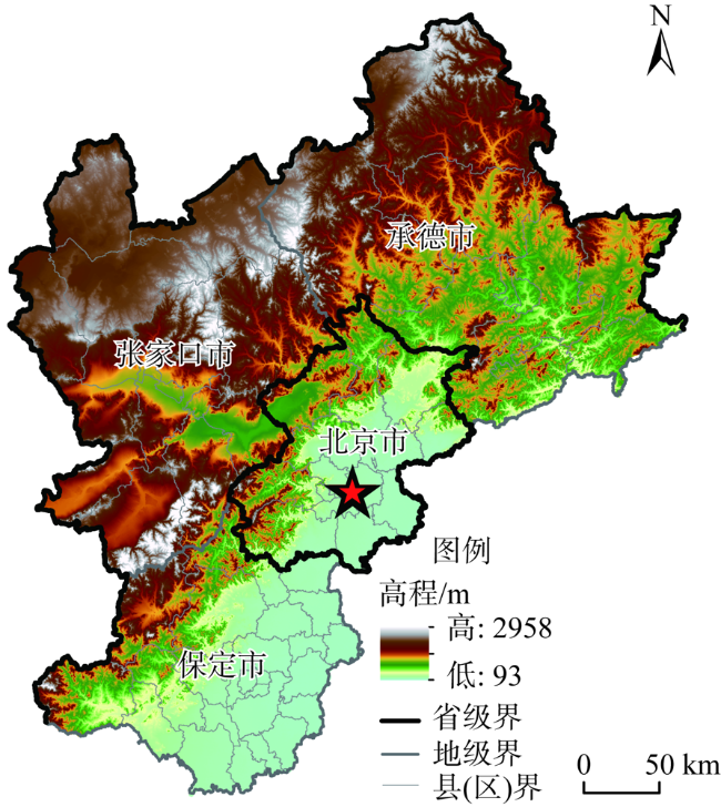
环首都地区城乡融合水平时空分异及乡村振兴路径
|
张海朋(1992- ),男,河南南阳人,博士研究生,研究方向为经济地理与区域可持续发展。E-mail: zhanghp.19b@igsnrr.ac.cn |
收稿日期: 2020-05-21
要求修回日期: 2020-08-25
网络出版日期: 2021-12-28
基金资助
国家自然科学基金项目(41461040)
北京市社会科学院重点项目(2018A5166)
北京市社会科学院一般项目(2019C5579)
版权
Spatio-temporal differentiation of urban-rural integration level and rural revitalization path in the Capital Region
Received date: 2020-05-21
Request revised date: 2020-08-25
Online published: 2021-12-28
Copyright
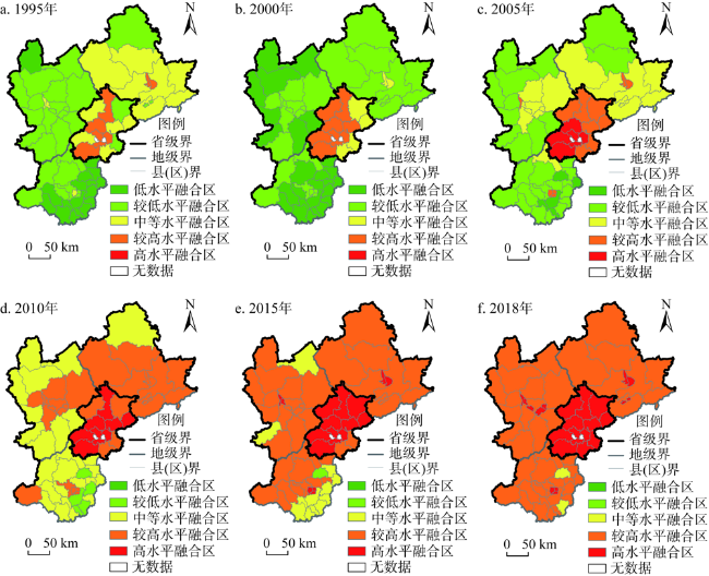
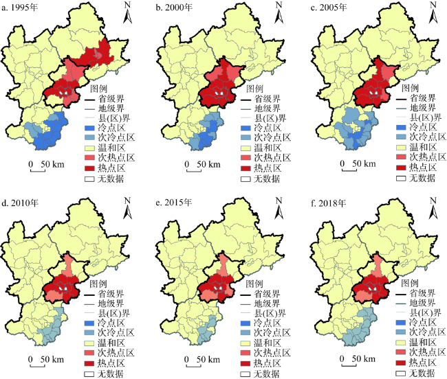
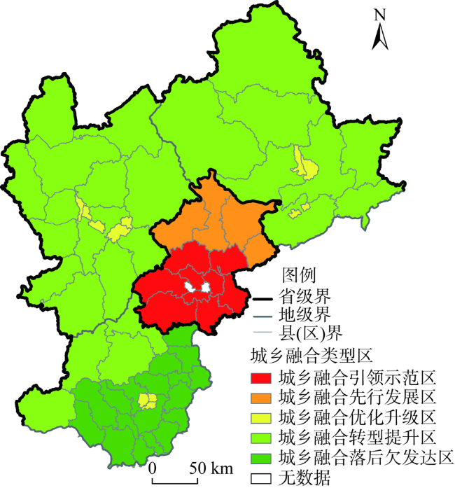
构建适于县域尺度的城乡融合评价指标体系,借助泰尔指数、ESDA方法分析1995—2018年间环首都地区县域尺度城乡融合水平时空分异特征,并划分出城乡融合发展类型区,提出差异化的乡村振兴路径。结果表明:(1)以2000年为拐点,环首都地区县域尺度城乡融合水平经历了先减后增的“U”型变化历程,整体趋势向好;城乡融合水平的区域差距先增后减,总体趋于缩小。北京及环京三市区域间的差异对总体城乡融合水平差异的贡献率略高于两类地区内部差异,环京三市内部差异是造成两类地区内部差异的主要原因;张家口市与保定市内部差异是影响环京三市城乡融合水平总体差异的主要原因,其中保定市内部差异占主导地位。(2)低水平融合区的数量波动减少,高水平融合区持续增加;城乡融合水平高、低值区的“核心—边缘”结构突出,且经历了“单组单核—多组多核—单组多核”的动态演变历程;城乡融合水平呈现显著的空间正相关性,集聚性先增后减;城乡融合热点区呈团簇状集聚在北京市域范围内,冷点区和次冷点区呈环形或带状布局在保定市中心城区外围,状态渐趋温和;城乡融合“冷热”空间格局与地理环境和社会经济发展背景联系紧密。(3)可将环首都地区划分为五类城乡融合区:城乡融合引领示范区、城乡融合先行发展区、城乡融合优化升级区、城乡融合转型提升区和城乡融合落后欠发达区,并根据各类型区特点,提出差异化的乡村振兴实施路径。
张海朋 , 何仁伟 , 李立娜 , 李光勤 . 环首都地区城乡融合水平时空分异及乡村振兴路径[J]. 自然资源学报, 2021 , 36(10) : 2652 -2671 . DOI: 10.31497/zrzyxb.20211014
On the basis of constructing the urban-rural integration evaluation index system suitable for the county scale including economic development, social life and ecological environment, this paper analyzed the urban-rural integration at the county scale in the Capital Region from 1995 to 2018 by using the Theil index and the ESDA method. The study also identified the types of urban-rural integration and proposed differentiated rural revitalization paths. The results indicate that: (1) The urban-rural integration level at the county scale in the Capital Region, with the turning point of 2000, experienced a "U"-shaped change process of decreasing first and then increasing. The overall level of urban-rural integration tended to increase. The regional gap in urban-rural integration level increased first and then decreased, and the overall trend tended to shrink. The contribution rate to the overall urban-rural integration level difference between the two regions (Beijing and the three cities around Beijing) was slightly higher than the internal difference between the two types of regions, the internal difference in the three cities around Beijing was the main reason for the internal differences between the two types of regions. The internal differences between Zhangjiakou and Baoding were the main reasons that led to the overall difference in the level of urban-rural integration in the three cities around Beijing, and the internal difference in Baoding was dominant. (2) The number of low-level fusion zones was decreasing, and the high-level fusion zones continued to increase. The "core-edge" structure of high and low level urban-rural integration areas was prominent, and has experienced a dynamic evolution stage of "single-group single-core" to "multi-groups multi-cores" to "single-group multi-cores". The level of urban-rural integration showed a significant spatial positive correlation, and the agglomeration increased first and then decreased. The hot spots of urban-rural integration areas were clustered in Beijing, and the cold spots and sub-cold spots were arranged in a ring or strip shape outside the central urban district of Baoding, and its state was getting milder. The "cold and hot" spatial pattern of urban-rural integration level was closely related to the geographical environment and socio-economic development background. (3) The area around the Capital Region could be divided into five types of urban-rural integration areas: urban-rural integration leading demonstration area, urban-rural integration advance development area, urban-rural integration optimization and upgrading area, urban-rural integration transformation and promotion area and urban-rural integration underdeveloped area. According to the characteristics of each type of district, this paper proposed differentiated rural revitalization implementation paths.
表1 环首都地区城乡融合评价指标体系Table 1 Evaluation index system for the urban-rural integration in the Capital Region |
| 目标层 | 维度层 | 指标层 | 具体指标 | 类型 | 功效 |
|---|---|---|---|---|---|
| 城乡融合发展指标 体系 | A经济发展(0.3720) | A1经济发展水平 (0.2261) | 人均GDP | 综合 | + |
| A2二元生产效率比 (0.2634) | (一产增加值/一产从业人员数)/(二三产业增加值/二三产业从业人员数) | 对比 | + | ||
| A 3农村就业结构 (0.2263) | 农村非农就业率 | 追赶 | + | ||
| A4城乡投资比 (0.2842) | 城镇固定资产投资额/农村固定资产投资额 | 对比 | - | ||
| B社会生活(0.3644) | B1教育水平 (0.2030) | 基础教育师生比 | 综合 | + | |
| B2医疗条件 (0.1870) | 每万人医疗床位数 | 综合 | + | ||
| B3城乡收入比 (0.2315) | 城镇人均可支配收入/农民人均纯收入 | 对比 | - | ||
| B4交通通达性 (0.2171) | 路网密度 | 综合 | + | ||
| B5财富状况 (0.1614) | 城乡居民人均储蓄存款余额 | 综合 | + | ||
| C生态环境(0.2636) | C1污染状况 (0.2463) | 亩均化肥施用量 | 追赶 | - | |
| C2生态条件 (0.4512) | 绿化覆盖率 | 综合 | + | ||
| C3环境状况 (0.3025) | PM2.5浓度 | 综合 | - |
注:括号中数值表示各项指标权重。 |
表2 环首都地区县域尺度城乡融合指数特征Table 2 Characteristics of the urban-rural integration index at the county scale in the Capital Region |
| 年份 | 最大值 | 最小值 | 平均值 | 泰勒指数 | ||||||||
|---|---|---|---|---|---|---|---|---|---|---|---|---|
| 研究区 | 北京 | 环京三市 | 研究区 | 北京 | 环京三市 | 研究区 | 北京 | 环京三市 | ||||
| 1995 | 0.4322 (朝阳区) | 0.4322 (朝阳区) | 0.3858 (双桥区) | 0.184 (容城县) | 0.2958 (通州区) | 0.184 (容城县) | 0.2866 | 0.3605 | 0.2685 | 0.0228 | ||
| 2000 | 0.4821 (朝阳区) | 0.4821 (朝阳区) | 0.328 (双桥区) | 0.1495 (蠡县) | 0.3315 (通州区) | 0.1495 (蠡县) | 0.2685 | 0.4067 | 0.2346 | 0.0454 | ||
| 2005 | 0.5419 (朝阳区) | 0.5419 (朝阳区) | 0.4265 (双桥区) | 0.2213 (定兴县) | 0.3787 (通州区) | 0.2213 (定兴县) | 0.3353 | 0.4616 | 0.3043 | 0.0278 | ||
| 2010 | 0.6761 (朝阳区) | 0.6761 (朝阳区) | 0.4801 (双桥区) | 0.2686 (定兴县) | 0.4346 (通州区) | 0.2686 (定兴县) | 0.3994 | 0.5319 | 0.3668 | 0.0211 | ||
| 2015 | 0.7174 (朝阳区) | 0.7174 (朝阳区) | 0.5702 (北市区) | 0.3497 (定兴县) | 0.5142 (通州区) | 0.3497 (定兴县) | 0.4697 | 0.5993 | 0.437 | 0.0157 | ||
| 2018 | 0.7325 (朝阳区) | 0.7325 (朝阳区) | 0.5889 (北市区) | 0.3527 (定兴县) | 0.5324 (通州区) | 0.3527 (定兴县) | 0.4735 | 0.6158 | 0.4467 | 0.0148 | ||
表3 环首都地区县域尺度城乡融合水平泰尔指数贡献率分解Table 3 Decomposition of the contribution rate of the Theil index in the urban-rural integration level at the county scale in the Capital Region (%) |
| 年份 | 区域内部 | 区域内部总和 | 区域间 | |
|---|---|---|---|---|
| 北京 | 环京三市 | |||
| 1995 | 7.26 | 58.74 | 66.00 | 34.00 |
| 2000 | 4.66 | 31.04 | 35.71 | 64.29 |
| 2005 | 6.00 | 36.64 | 42.63 | 57.37 |
| 2010 | 9.62 | 31.68 | 41.30 | 58.70 |
| 2015 | 8.41 | 40.17 | 48.58 | 51.42 |
| 2018 | 8.18 | 39.95 | 48.13 | 51.87 |
表4 环京三市县域尺度城乡融合水平泰尔指数贡献率分解Table 4 Decomposition of the contribution rate of the Theil index in the urban-rural integration level at the county scale in the three cities around Beijing |
| 年份 | 泰尔指数 | 区域内部/% | 区域内部总和/% | 区域间/% | ||
|---|---|---|---|---|---|---|
| 承德市 | 张家口市 | 保定市 | ||||
| 1995 | 0.0178 | 4.80 | 9.73 | 36.09 | 50.61 | 49.39 |
| 2000 | 0.0201 | 4.13 | 14.96 | 46.72 | 65.82 | 34.18 |
| 2005 | 0.0139 | 8.54 | 19.59 | 43.84 | 71.97 | 28.03 |
| 2010 | 0.0091 | 10.87 | 21.96 | 46.75 | 79.58 | 20.42 |
| 2015 | 0.0076 | 9.95 | 23.64 | 53.02 | 86.61 | 13.39 |
| 2018 | 0.0072 | 8.67 | 25.22 | 54.23 | 88.12 | 11.88 |
表5 环首都地区县域尺度城乡融合水平的全局莫兰指数Table 5 The global Moran index of the urban-rural integration level at the county scale in the Capital Region |
| 年份 | 1995 | 2000 | 2005 | 2010 | 2015 | 2018 |
|---|---|---|---|---|---|---|
| Moran's I | 0.6724 | 0.7335 | 0.6728 | 0.6346 | 0.6106 | 0.6032 |
| P-value | 0.0003 | 0.0012 | 0.0005 | 0.0022 | 0.0423 | 0.0537 |
| Z-score | 9.2738 | 10.1558 | 9.3078 | 8.8638 | 8.4943 | 8.2789 |
表6 环首都地区县域尺度城乡融合类型区划分依据及其特征Table 6 Division and characteristics of urban-rural integration types at the county scale in the Capital Region |
| 城乡融合类型区 | 城乡融合水平 | “核心—边缘”特征 | 城乡融合临近依存性 | 空间区位 | 主要特征 | 县区 |
|---|---|---|---|---|---|---|
| 城乡融合引领示范区 | 高 | 都市核心区 | 热点区 | 北京城市功能区 | 经济最为发达,人口最密集,城镇化水平最高,农业农村比例最小的地区 | 朝阳、海淀、丰台、门头沟、房山、顺义、昌平、大兴、通州9区 |
| 城乡融合先行发展区 | 较高 | 都市外围区 | 北京市温和区和次热点区 | 北京城市生态涵养区 | 山区地貌,自然风光良好,生态环境优越,是首都重要的生态屏障和水源保护地,农业农村比例高于北京城市中心区,城镇化发展较快,毗邻都市核心区,农村非农就业程度较高 | 延庆、怀柔、密云、平谷4区 |
| 城乡融合优化升级区 | 较高 | 城镇核心区 | 温和区 | 环首都三市市辖区 | 地级市市辖区,在区域经济发展中起引领作用,人口高度集聚,城镇化率较高,农业农村比例相对较小,基础设施相对完备,城乡融合水平仅次于北京城市中心区 | 张家口桥东区、桥西区、宣化区、下花园区,承德双桥区、双滦区、鹰手营子矿区,保定新市区、北市区、南市区10区 |
| 城乡融合转型提升区 | 较低 | 都市边缘区 | 温和区 | 环首都山区 | 地处太行山—燕山—阴山连绵带,山脉纵横,地形起伏,海拔高差达2800多m,自然风光秀美,但环境恶劣,生态脆弱,农业生产条件差,贫困现象集中连片 | 张家口市辖区外的13个县域,承德市辖区外的8个县域以及保定市的涞水县、涞源县、易县和阜平县,总计25县区 |
| 城乡融合落后欠发达区 | 低 | 都市边缘区 | “冷—次冷”点区 | 冀北平原区 | 地处华北平原,地形平坦,水土资源较好,农业发展优势突出,农业农村比例大,农村非农就业比例低,同时其距离首都相对较远,所受“虹吸”效应小,发展限制程度低 | 保定市满城县、清苑县、徐水县、定兴县、高阳县、容城县、涿州市、定州市、顺平县、博野县、雄县、唐县等18县区 |
| [1] |
刘彦随. 中国新时代城乡融合与乡村振兴. 地理学报, 2018, 73(4):637-650.
[
|
| [2] |
何仁伟. 城乡融合与乡村振兴: 理论探讨、机理阐释与实现路径. 地理研究, 2018, 37(11):2127-2140.
[
|
| [3] |
刘春芳, 张志英. 从城乡一体化到城乡融合:新型城乡关系的思考. 地理科学, 2018, 38(10):1624-1633.
[
|
| [4] |
刘彦随, 严镔, 王艳飞. 新时期中国城乡发展的主要问题与转型对策. 经济地理, 2016, 36(7):1-8.
[
|
| [5] |
|
| [6] |
李智, 张小林, 陈媛, 等. 基于城乡相互作用的中国乡村复兴研究. 经济地理, 2017, 37(6):144-150.
[
|
| [7] |
方方, 何仁伟, 李立娜. 京津冀地区乡村振兴地域模式研究: 基于乡村非农就业与农民增收的空间效应. 地理研究, 2019, 38(3):699-712.
[
|
| [8] |
张毓雄, 汤跃跃. 我国城乡融合发展的整体性研究与反思: 基于主题检索的CSSCI文献. 社会科学家, 2018, (4):64-69.
[
|
| [9] |
魏后凯. 新常态下中国城乡一体化格局及推进战略. 中国农村经济, 2016, (1):2-16.
[
|
| [10] |
陈肖飞, 姚士谋, 张落成. 新型城镇化背景下中国城乡统筹的理论与实践问题. 地理科学, 2016, 36(2):188-195.
[
|
| [11] |
姜长云. 建立健全城乡融合发展的体制机制和政策体系. 区域经济评论, 2018, (3):114-116.
[
|
| [12] |
|
| [13] |
张新林, 仇方道, 朱传耿. 时空交互视角下淮海经济区城乡融合发展水平演化. 自然资源学报, 2020, 35(8):1867-1880.
[
|
| [14] |
周佳宁, 毕雪昊, 邹伟. “流空间”视域下淮海经济区城乡融合发展驱动机制. 自然资源学报, 2020, 35(8):1881-1896.
[
|
| [15] |
周佳宁, 秦富仓, 刘佳, 等. 多维视域下中国城乡融合水平测度、时空演变与影响机制. 中国人口·资源与环境, 2019, 29(9):166-176.
[
|
| [16] |
杨开忠. 乡村振兴以都市圈为主要依托. 理论导报, 2018, (6):54-55.
[
|
| [17] |
何仁伟, 樊杰, 李光勤. 环京津贫困带的时空演变与形成机理. 经济地理, 2018, 38(6):1-9.
[
|
| [18] |
方创琳. 中国新型城镇化高质量发展的规律性与重点方向. 地理研究, 2019, 38(1):13-22.
[
|
| [19] |
王传松. 城乡统筹发展水平综合评价: 以重庆为例. 中国农业资源与区划, 2013, 34(5):82-91.
[
|
| [20] |
王艳飞, 刘彦随, 严镔, 等. 中国城乡协调发展格局特征及影响因素. 地理科学, 2016, 36(1):20-28.
[
|
| [21] |
杨园园, 臧玉珠, 李进涛. 基于城乡转型功能分区的京津冀乡村振兴模式探析. 地理研究, 2019, 38(3):684-698.
[
|
| [22] |
刘浩, 马琳, 李国平. 京津冀地区经济发展冷热点格局演化及其影响因素. 地理研究, 2017, 36(1):97-108.
[
|
| [23] |
姜会明, 孙雨, 王健, 等. 中国农民收入区域差异及影响因素分析. 地理科学, 2017, 37(10):1546-1551.
[
|
| [24] |
李博, 张文忠, 余建辉. 考虑环境约束的中国资源型城市全要素能源效率及其差异研究. 自然资源学报, 2016, 31(3):377-389.
[
|
| [25] |
张海鹏. 中国城乡关系演变70年: 从分割到融合. 中国农村经济, 2019, (3):2-18.
[
|
| [26] |
刘彦随, 张紫雯, 王介勇. 中国农业地域分异与现代农业区划方案. 地理学报, 2018, 73(2):203-219.
[
|
| [27] |
陈玉, 孙斌栋. 京津冀存在“集聚阴影”吗: 大城市的区域经济影响. 地理研究, 2017, 36(10):1936-1946.
[
|
| [28] |
孙斌栋, 丁嵩. 多中心空间结构经济绩效的研究进展及启示. 地理科学, 2017, 37(1):64-71.
[
|
/
| 〈 |
|
〉 |