
基于SCGE的国土空间规划模拟框架CTSPM及其在国土空间安全模拟仿真中的应用
|
沈体雁(1971- ),男,湖北天门人,博士,教授,主要从事城市规划治理、国土空间规划、产业集群发展和空间计量经济学等方面的教学科研工作。E-mail: tyshen@pku.edu.cn |
收稿日期: 2020-07-03
要求修回日期: 2021-03-22
网络出版日期: 2021-11-28
基金资助
北京高等学校卓越青年科学家项目(JJWZYJH01201910003010)
国家社会科学基金重大项目(17ZDA055)
国家自然科学基金重大项目(71733001)
科技部重大专项(2019YFB1404604)
版权
Simulation framework of China's Territorial Spatial Planning Model (CTSPM) based on Spatial Computable General Equilibrium Model (SCGE) and its application in land and space safety simulation
Received date: 2020-07-03
Request revised date: 2021-03-22
Online published: 2021-11-28
Copyright
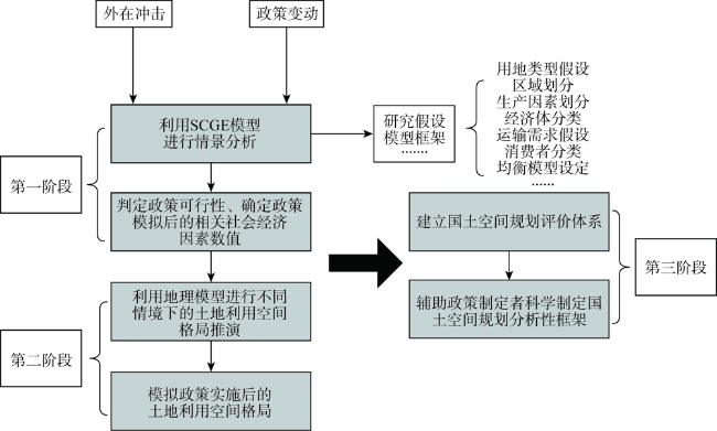
土地利用指标的区域配置与部门配置是我国国土空间规划体系的核心问题。如何在贯彻落实国家意志和中央战略的前提下,根据我国不同类型自然地理区划和经济社会区划的发展实际,特别是根据城镇化格局定型区、发展型城镇化地区和收缩型城镇化地区等三类不同地区的土地利用的实际,充分顾及各级地方政府的发展意愿,优化配置各类用地指标,是本轮国土空间规划不可或缺的首要的基本任务。基于此,建立一个基于空间可计算一般均衡模型(SCGE)的多尺度、多区域、多情景国土空间规划模拟分析框架(CTSPM),提出该框架在国土空间安全模拟仿真中的实际应用场景,以支持多种国家发展情景和土地指标分配方案下国土空间格局模拟分析,及其经济社会影响和生态环境影响分析,为各地区、各部门之间的土地指标“博弈”提供“辩论”平台,为科学编制国土空间规划以及深度理解国土空间安全的跨区域影响提供分析性框架。
关键词: 国土空间规划; 国土空间安全; 土地利用指标分配; 空间均衡模型(SCGE); 国土空间规划模拟模型框架(CTSPM)
沈体雁 , 温璐歌 . 基于SCGE的国土空间规划模拟框架CTSPM及其在国土空间安全模拟仿真中的应用[J]. 自然资源学报, 2021 , 36(9) : 2320 -2334 . DOI: 10.31497/zrzyxb.20210911
The regional and department allocation of land use index is the key problem of National Territory Development Planning System. The most important task in this round of territorial space planning remains the optimal allocation of land use indexes of different types with the full consideration of the development wills of local governments at all levels. The task should be in line with the actual development of China's diverse physical geographic regionalization and economic and social regionalization, in particular, the actual land use in three different regions, namely, urbanization-forming region, urbanization-developing region and urbanization-shrinking region with the implementation of state will and national strategy. In this paper, the authors seek to establish a multi-scale, multi-region and multi-context simulation framework of China's Territorial Spatial Planning Model (CTSPM) based on the Spatial Computable General Equilibrium (SCGE) model, and proposes the actual application contexts in the safety simulation of territorial space for the support of the national territorial spatial framework simulation and analysis of multiple national development contexts and land index allocation planning as well as the analysis of its socio-economic influences and ecological environmental influences. The authors hope that this framework would serve as a "debate" platform for the "game" for obtaining land index between regions and departments and also an analytical framework for a scientific national territorial and spatial planning and a deep understanding of the cross-regional influences of national spatial safety.
表1 不同阶段模型适用性对比Table 1 Applicability comparison of different models in different stages |
| 不同阶段模型类型及分类 | 理论奠基阶段 | 定量革命阶段 | 新综合阶段 | ||||
|---|---|---|---|---|---|---|---|
| PE | GE | CGE | 地理模型 | SCGE+地理模型 | |||
| 经济含义解读程度 | 局部解读 | 较高 | 较高 | 低 | 较高 | ||
| 经济相关因素处理 | 内生 | 内生 | 内生 | 外生 | 内生 | ||
| 应用周期长度 | 长期 | 长期 | 长期 | 短期/长期 | 长期 | ||
| 应用范围尺度 | 宏观大尺度单一要素(全球) | 宏观大尺度多要素(全球) | 宏观大尺度多要素(全球) | 微观多尺度多要素(全球、区域皆可) | 宏观多尺度多要素(全球、区域皆可) | ||
| 政策评估 | √ √ | √ √ √ | √ √ √ | √ | √ √ √ | ||
| 所需数据完整度 | √ √ | √ | √ | √ √ √ | √ √ | ||
| 空间因素 | 部分考虑 | 部分考虑 | 部分考虑 | 考虑 | 考虑 | ||
表2 影响SCGE模型发展过程的代表人物及主要贡献Table 2 Representatives and main contributions that influence the development process of the SCGE model |
| 阶段 | 代表人物 | 对运输条件的假设 | 主要贡献 |
|---|---|---|---|
| 第一阶段 | Jones等[26] | 采用统一的输入系数 | (1)在该模型的应用中,Jones等[26]根据税率政策,政府间转移以及税收和补贴的取消的希克斯等值变异和区域间净劳动力流动来计算福利效应(2)在所有涉及到的政策假设情景下,作者发现政策变化对地区的影响是巨大的,并认为使用该模型方法对于研究联邦和地区财政政策变化对地区的影响是有价值的 |
| Buckley[27] | 采用Round[28]提出的方法,将运输和货运当作商品,并在空间上可以交易 | 通过明确考虑运输和批发服务,并将其作为可以在地区之间交易的商品,作者得到交通运输是否纳入模型会对政策模拟产生影响 | |
| 第二阶段 | Roson[29] | 应用CGE模型、分散的空间价格均衡模型以及货运网络模型建立意大利的货运模型MITER | 将SPE模型与CGE模型融合,通过三个模型的迭代计算得到最终基于区域与货运数量的运费,并以此为原理建立了意大利的货运模型 |
| 第三阶段 | Kilkenny[30] | 工农业的运输成本呈均匀分布 | (1)运输成本与城市集中度之间的关系不是单调的,在运输成本下降时,农村地区的集中度首先下降,然后多样性和人口会呈现增加的态势(2)运输成本的下降在一定程度上可以改善所有参与者的福利 |
| Fan等[31] | 采用冰山运输成本假说 | (1)由于前后向联系微弱,因此不存在以农业和服务业为主产业的城市(2)运输成本的降低大大改变了平衡结构。与Kilkenny[30]一样,较低的运输成本导致大城市人口密度更加统一。当运输成本降低到原始水平的十分之一时,新的平衡构型就非常接近于单中心的核心—外围结构 | |
| Freidl等[32] | 采用通勤成本替代运输成本 | 应对城市蔓延的最好策略是改善交通运输工具以及采用警戒线定价 | |
| 第四阶段 | Wing等[33] | 在传统CGE模型中添加运输部门 | 以美国大都市区为研究对象建立“空间分解”CGE模型,通过分解美国SAM表得到相关大都市区数据,明确表示行业对中间投入的使用,该模型阐明了宏观气候变化政策可能影响区域增长和燃烧活动减少带来的二次空气污染收益的空间分布的潜力 |
| Wan等[34] | 北京人口疏解政策可实施性的模拟 |
表3 不同情境下新冠肺炎疫情对主要宏观经济指标的影响Table 3 The impact of COVID-19 on major macroeconomic indicators in China under different scenarios |
| 经济指标 | 情景1 | 情景2 |
|---|---|---|
| 实际GDP | -0.15 | -0.26 |
| 资本投资 | -0.06 | -0.11 |
| 居民收入 | -0.073 | -0.13 |
| 居民消费 | -2.7 | -4.2 |
| CPI | 0.16 | 0.29 |
| [1] |
中共中央. 深化党和国家机构改革方案. 人民日报, 2018-03-21.
[The Central Committee of the Communist Party of China. Deepen the reform plan of the party and state institutions. People's Daily, 2018-03-21. ]
|
| [2] |
国务院. 关于印发全国国土规划纲要(2016—2030年)的通知. 人民日报, 2017-02-05.
[State Council. Notice on printing and distributing the outline of national land planning (2016-2030). People's Daily, 2017-02-05.]
|
| [3] |
吴洪涛. 自然资源信息化总体架构下的智慧国土空间规划. 城乡规划, 2019, (6):6-10.
[
|
| [4] |
沈体雁, 王芝田, 吕永强, 等. 城市与区域规划支持系统. 北京: 科学出版社, 2015.
[
|
| [5] |
王军, 应凌霄, 钟莉娜. 新时代国土整治与生态修复转型思考. 自然资源学报, 2020, 35(1):26-36.
[
|
| [6] |
中共中央国务院关于建立国土空间规划体系并监督实施的若干意见. http://www.gov.cn/zhengce/2019-05/23/content_5394187.htm, 2019-05-23.
[Several opinions of the Central Committee of the Communist Party of China and the State Council on establishing the land spatial planning system and supervising the implementation. http://www.gov.cn/zhengce/2019-05/23/content_5394187.htm, 2019-05-23.]
|
| [7] |
习近平. 在网信工作座谈会上的讲话. http://www.xinhuanet.com//politics/2016-04/25/c_1118731175.htm, 2016-04-25.
[
|
| [8] |
|
| [9] |
|
| [10] |
柴彦威, 刘伯初, 刘瑜, 等. 基于多源大数据的城市体征诊断指数构建与计算: 以上海市为例. 地理科学, 2018, 38(1):1-10.
[
|
| [11] |
甄峰, 张姗琪, 秦萧, 等. 从信息化赋能到综合赋能: 智慧国土空间规划思路探索. 自然资源学报, 2019, 34(10):2060-2072.
[
|
| [12] |
自然资源部. 《市级国土空间总体规划编制指南(试行)》有关情况新闻发布会. http://www.scio.gov.cn/xwfbh/gbwxwfbh/xwfbh/gtzyb/Document/1688461/1688461.htm, 2020-09-24.
[Ministry of Natural Resource of the People's Republic of China. Guidelines for the Compilation of Municipal Land and Space Master Plans (for Trial Implementation) press conference. http://www.scio.gov.cn/xwfbh/gbwxwfbh/xwfbh/gtzyb/Document/1688461/1688461.htm, 2020-09-24.]
|
| [13] |
约翰·海因里希·冯·杜能. 孤立国同农业和国民经济的关系. 吴衡康译. 北京: 商务印书馆, 1986.
[
|
| [14] |
阿尔弗雷德·韦伯. 工业区位论. 李刚剑等译. 北京: 商务印书馆, 1997.
[
|
| [15] |
沃尔特·克里斯泰勒. 德国南部中心地原理. 常正文,王中兴译 北京: 商务印书馆, 2010.
[
|
| [16] |
奥古斯特·勒施. 经济空间秩序. 王守礼译. 北京: 商务印书馆, 2010.
[
|
| [17] |
|
| [18] |
杨开忠, 沈体雁, 方森, 等. 区位与空间经济:关于产业区位、市场区、土地利用、贸易和城市结构的一般理论. 北京: 北京大学出版社, 2011: 16-80.
[
|
| [19] |
|
| [20] |
|
| [21] |
|
| [22] |
|
| [23] |
|
| [24] |
|
| [25] |
|
| [26] |
|
| [27] |
|
| [28] |
|
| [29] |
|
| [30] |
|
| [31] |
|
| [32] |
|
| [33] |
|
| [34] |
|
| [35] |
|
| [36] |
|
| [37] |
|
| [38] |
|
| [39] |
|
| [40] |
|
| [41] |
|
| [42] |
|
| [43] |
|
| [44] |
习近平. 在中国共产党第十九次全国代表大会上的报告. http://news.workercn.cn/607/201710/27/171027193947646.shtml, 2017-10-27.
[
|
| [45] |
|
| [46] |
|
| [47] |
|
| [48] |
|
| [49] |
|
| [50] |
|
| [51] |
李锋, 孙根年. 基于旅游本底线法(TBLM)的旅游危机事件研究: 以2003年“SARS”事件为例. 人文地理, 2006, 21(4):102-105.
[
|
| [52] |
|
| [53] |
|
| [54] |
|
| [55] |
|
| [56] |
赵宏波, 魏甲晨, 王爽, 等. 大城市新冠肺炎疫情风险评估与精准防控对策: 以郑州市为例. 经济地理, 2020, 40(4):103-109, 124.
[
|
| [57] |
王姣娥, 杜德林, 魏冶, 等. 新冠肺炎疫情的空间扩散过程与模式研究. 地理研究, 2020, 39(7):1450-1462.
[
|
| [58] |
周成虎, 裴韬, 杜云艳, 等. 新冠肺炎疫情大数据分析与区域防控政策建议. 中国科学院院刊, 2020, 35(2):200-203.
[
|
| [59] |
张凯煌, 千庆兰. 新冠疫情对中国经济的影响及政策讨论: 来自上市企业的证据. 热带地理, 2020, 40(3): 396-407.
[
|
| [60] |
黄茂兴, 廖萌. 新冠肺炎疫情对我国中小企业的影响及应对策略. 福建论坛: 人文社会科学版, 2020, 40(5):59-68.
[
|
| [61] |
|
| [62] |
|
| [63] |
|
| [64] |
郑世林. 新冠疫情对我国行业经济的冲击及政策建议. https://finance.sina.com.cn/China/gncj/2020-02-06/doc-imxyqvz08067.shtml, 2020-02-06.
[
|
/
| 〈 |
|
〉 |