
扎龙湿地丹顶鹤繁殖栖息地的选择及扩散
|
宫兆宁(1976- ),女,山东青岛人,博士,教授,主要从事湿地生态遥感方面的研究。E-mail: gongzhn@163.com |
收稿日期: 2019-11-08
修回日期: 2020-05-11
网络出版日期: 2021-10-28
基金资助
国家自然科学基金项目(41971381)
北京水务局重点项目(TAHP-2018-ZB-YY-490S)
版权
Habitat selection and dispersal of red-crowned cranes during breeding period in Zhalong Wetland National Nature Reserve
Received date: 2019-11-08
Revised date: 2020-05-11
Online published: 2021-10-28
Copyright
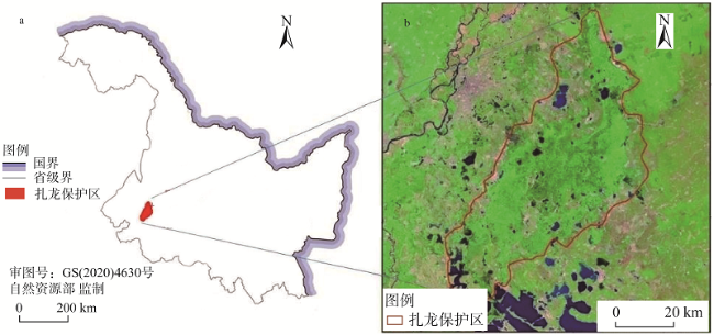
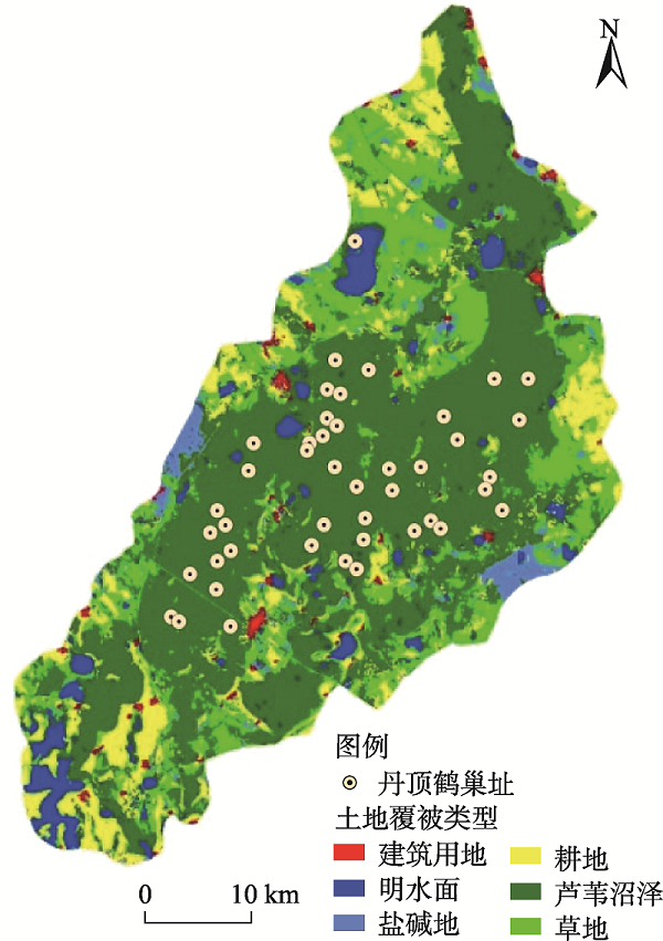
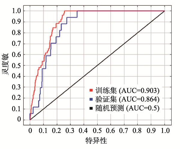
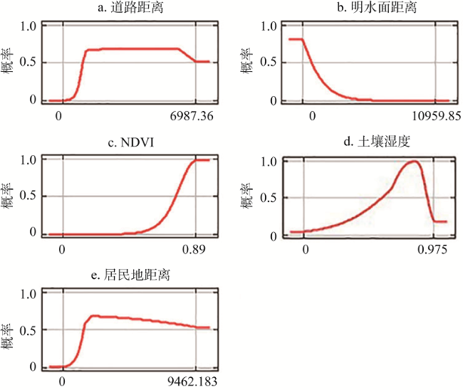
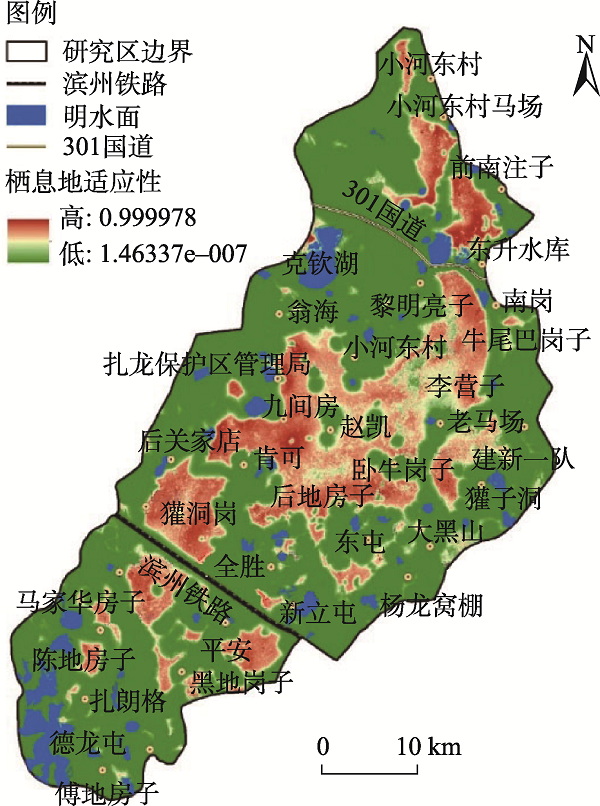
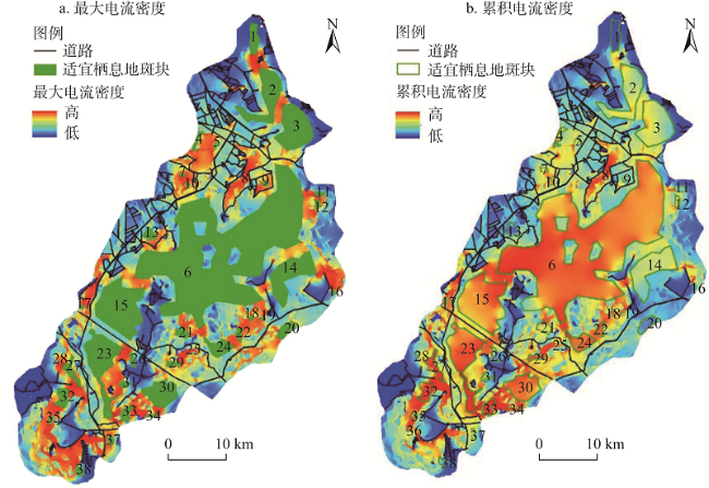
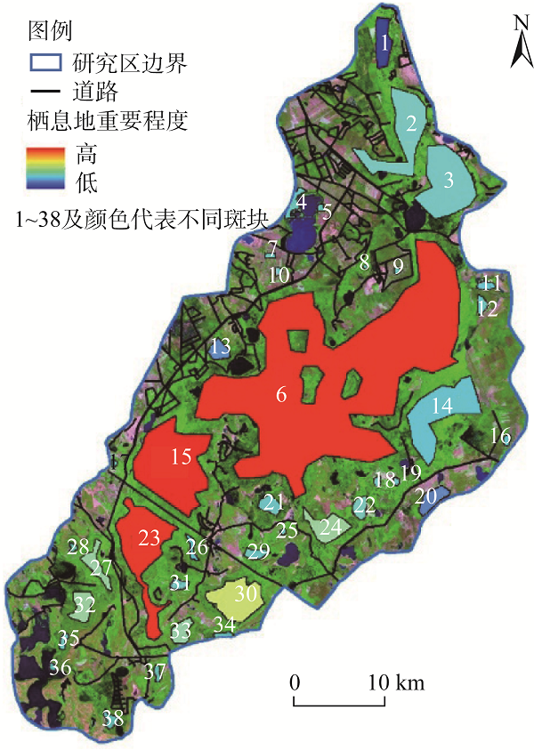
景观演变对野生动物栖息地质量和连接度造成的影响,一直是威胁全球生物多样性保护的关键问题,开展扎龙湿地丹顶鹤(Grus japonensis)繁殖栖息地选择及繁殖期生境间的扩散研究,对野生丹顶鹤的保护具有重要的意义。首先利用需要“出现点”的生态位MAXENT模型,进行适宜栖息地选择研究。从水源、食物、干扰、隐蔽物四个方面选择明水面距离、土壤湿度、NDVI、道路距离和居民地距离五个环境变量作为丹顶鹤繁殖栖息地选择的影响因子,预测扎龙保护区可供丹顶鹤进行营巢繁殖的栖息地分布,并分析各影响因子的反应曲线。结果显示:丹顶鹤易于选择远离道路和居民地干扰且靠近明水面的区域作为营巢栖息地,栖息地土壤湿度较高并且植被覆盖较多。从MAXENT模型中提取了38个适宜栖息地斑块,基于电路理论模拟丹顶鹤繁殖期失去飞行能力时的多路径扩散,最大电流密度图突出了可能的“夹点”,模拟出具有一定宽度范围的连接区域,可供丹顶鹤在繁殖期间进行扩散。累积电流密度图突出了在维持网络连通性方面起到积极作用的斑块,并进行面积加权来评估适宜栖息地斑块的综合重要性。结果表明,在MAXENT模型预测出的适宜栖息地斑块基础上,考虑丹顶鹤繁殖期的迁移扩散行为,利用累积电流密度面积加权来评估适宜栖息地斑块的综合重要性,得到的适宜性等级更符合丹顶鹤真实巢址的分布。研究成果可为保护区丹顶鹤栖息繁殖生境的恢复和保护提供科学依据。
宫兆宁 , 苏朔 , 杜博 , 关晖 , 张强 . 扎龙湿地丹顶鹤繁殖栖息地的选择及扩散[J]. 自然资源学报, 2021 , 36(8) : 1964 -1975 . DOI: 10.31497/zrzyxb.20210805
The impact of landscape changes on the quality and connectivity of habitats for multiple wildlife species is a global conservation concern. Zhalong Wetland is not only the priority areas of biodiversity conservation in China, but also the largest haibitat in the world with a large number of red-crowned cranes (Grus japonensis) breeding. The red-crowned crane was listed as a globally endangered species by the IUCN Red List of threatened species (IUCN, 2012), which is the umbrella species and the most sensitive biological indicator species of ecological changes in Zhalong Wetland. The selection of breeding habitat and the dispersal between suitable habitats in the study area are of great significance to the protection of wild red-crowned cranes. Firstly five variables (distance to water, soil wetness, NDVI, distance to roads and distance to buildings) were derived, which was hypothesized to influence the quality of habitat for red-crowned cranes according to the actual investigation within an area encompassing the entire Zhalong Nature Reserve. The MAXENT model was used to predict the suitable habitat distribution of red-crowned crane and analyze the response curve of each factor. The results showed that the red-crowned cranes were more likely to inhabit far away from roads and residents, and the breeding habitat might be close to water with more vegetation in a higher soil moisture condition. Finally, 38 suitable habitat patches were extracted from MAXENT model to simulate the multipath dispersal of red-crowned cranes when they lost flight ability based on circuit theory in landscape connectivity. Our map of maximum current flow between patches highlighted the possible pinch points, which can be used for red-crowned cranes moving directly between patch pairs. Current flow summed across all pairs of patches highlighted areas important for keeping the entire network connected. The results show that based on the suitable habitat patches predicted by MaxEnt model, considering the migration and diffusion behavior of the red-crowned crane in the breeding period, the comprehensive importance of the suitable habitat patches is evaluated by using the area weighting of the cumulative current density, and the suitability level is more consistent with the real nest distribution of the red-crowned cranes. Map results can be used to support the planning efforts concerned with the maintenance of red-crowned cranes metapopulation structure, as well as to protect the landscape features that facilitate the dispersal process.
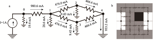
表1 电路理论中物理学术语与其生态学意义对照表Table 1 Comparison of physical terms and their ecological meanings in circuit theory |
| 名词 | 生态学解释 |
|---|---|
| 电阻 | 与生态学中景观阻力概念相似,电阻阻值越大,景观对物种扩散的阻碍能力越强 |
| 电压 | 用来预测物种离开任意一个焦点并成功到达下一个给定焦点的可能概率 |
| 电流 | 表示物种在运动过程中沿某一路径扩散的概率 |
| 电源 | 表示物种进行扩散过程前的种群数量 |
| 接地 | 表示物种在某一焦点停留,不继续扩散过程 |
表2 不同土地覆被类型阻力赋值Table 2 Resistance assignment for different land cover types |
| 土地覆被类型 | 阻力值 |
|---|---|
| 芦苇沼泽 | 1 |
| 明水面 | 10 |
| 草地 | 25 |
| 盐碱地 | 50 |
| 耕地 | 75 |
| 建筑道路用地 | Infinite |
| [1] |
|
| [2] |
魏辅文, 聂永刚, 苗海霞, 等. 生物多样性丧失机制研究进展. 科学通报, 2014, 59(6): 430-437.
[
|
| [3] |
刘慧明, 高吉喜, 张海燕, 等. 2010—2015年中国生物多样性保护优先区域人类干扰程度评估. 地球信息科学学报, 2017, 19(11): 1456-1465.
[
|
| [4] |
佟守正, 吕宪国, 苏立英, 等. 扎龙湿地生态系统变化过程及影响因子分析. 湿地科学, 2008, 6(2): 179-184.
[
|
| [5] |
|
| [6] |
|
| [7] |
杨维康, 钟文勤, 高行宜. 鸟类栖息地选择研究进展. 干旱区研究, 2000, 17(3): 71-78.
[
|
| [8] |
|
| [9] |
吴昌广, 周志翔, 王鹏程, 等. 景观连接度的概念、度量及其应用. 生态学报, 2010, 30(7): 1903-1910.
[
|
| [10] |
陈春娣, 贾振毅, 吴胜军, 等. 基于文献计量法的中国景观连接度应用研究进展. 生态学报, 2017, 37(10): 3243-3255.
[
|
| [11] |
欧维新, 袁薇锦. 基于景观连接度的盐城滨海湿地丹顶鹤生境斑块重要性评价. 资源科学, 2015, 37(4): 823-831.
[
|
| [12] |
张宇, 李丽, 吴巩胜, 等. 基于生境斑块的滇金丝猴景观连接度分析. 生态学报, 2016, 36(1): 51-58.
[
|
| [13] |
|
| [14] |
李慧, 李丽, 吴巩胜, 等. 基于电路理论的滇金丝猴生境景观连通性分析. 生态学报, 2018, 38(6): 2221-2228.
[
|
| [15] |
张玉红, 苏立英, 于万辉, 等. 扎龙湿地景观动态变化特征. 地理学报, 2015, 70(1): 131-142.
[
|
| [16] |
冯夏清, 章光新. 自然—人为双重作用下扎龙湿地水文情势分析. 资源科学, 2010, 32(12): 2316-2323.
[
|
| [17] |
邹红菲, 朱井丽, 吴庆明, 等. 扎龙保护区湿地注水恢复期鸟类群落多样性. 野生动物学报, 2016, 37(3): 207-215.
[
|
| [18] |
刘学昌, 吴庆明, 邹红菲, 等. 丹顶鹤(Grus japonensis)东、西种群巢址选择的分异. 生态学报, 2009, 29(8): 4483-4491.
[
|
| [19] |
|
| [20] |
朱耿平, 乔慧捷. Maxent模型复杂度对物种潜在分布区预测的影响. 生物多样性, 2016, 24(10): 1189-1196.
[
|
| [21] |
高蓓, 卫海燕, 郭彦龙, 等. 应用GIS和最大熵模型分析秦岭冷杉潜在地理分布. 生态学杂志, 2015, 34(3): 843-852.
[
|
| [22] |
|
| [23] |
宋利利, 秦明周. 整合电路理论的生态廊道及其重要性识别. 应用生态学报, 2016, 27(10): 3344-3352.
[
|
| [24] |
周志华. 机器学习. 北京: 清华大学出版社, 2016: 31-36.
[
|
| [25] |
赵正阶. 中国鸟类志. 长春: 吉林科学技术出版社, 2001: 414-415.
[
|
| [26] |
|
| [27] |
江红星, 刘春悦, 钱法文, 等. 基于3S技术的扎龙湿地丹顶鹤巢址选择模型. 林业科学, 2009, 45(7): 76-83.
[
|
| [28] |
李枫, 杨红军. 扎龙湿地丹顶鹤巢址选择研究. 东北林业大学学报, 1999, 27(6): 57-60.
[
|
| [29] |
郭殿繁, 臧淑英, 那晓东. 扎龙保护区丹顶鹤栖息地适宜性评价. 地理与地理信息科学, 2015, 31(1): 54-58.
[
|
| [30] |
|
| [31] |
秦喜文, 张树清, 李晓峰, 等. 基于证据权重法的丹顶鹤栖息地适宜性评价. 生态学报, 2009, 29(3): 1074-1082.
[
|
| [32] |
王志强, 陈志超, 郝成元. 基于HSI模型的扎龙国家级自然保护区丹顶鹤繁殖生境适宜性评价. 湿地科学, 2009, 7(3): 197-201.
[
|
| [33] |
李方满, 李佩. 丹顶鹤与白枕鹤的领域比较. 生态学杂志, 1999, 18(6): 33-37.
[
|
| [34] |
|
/
| 〈 |
|
〉 |