
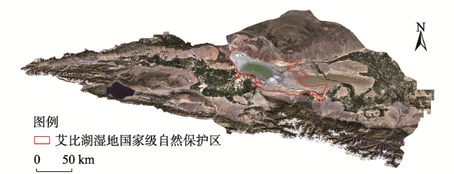
中国艾比湖湿地识别及其时空动态变化
|
丁建丽(1974- ),男,山东菏泽人,博士,教授,博士生导师,主要从事干旱区环境演变与遥感应用研究。E-mail: watarid@xju.edu.cn |
收稿日期: 2020-01-20
修回日期: 2020-10-19
网络出版日期: 2021-10-28
基金资助
新疆水专项(2020.B-001)
国家自然科学基金项目(41961059)
国家自然科学基金项目(41771470)
版权
Ebinur Lake wetland identification and its spatio-temporal dynamic changes
Received date: 2020-01-20
Revised date: 2020-10-19
Online published: 2021-10-28
Copyright
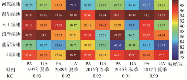
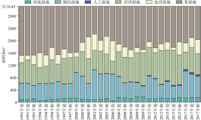
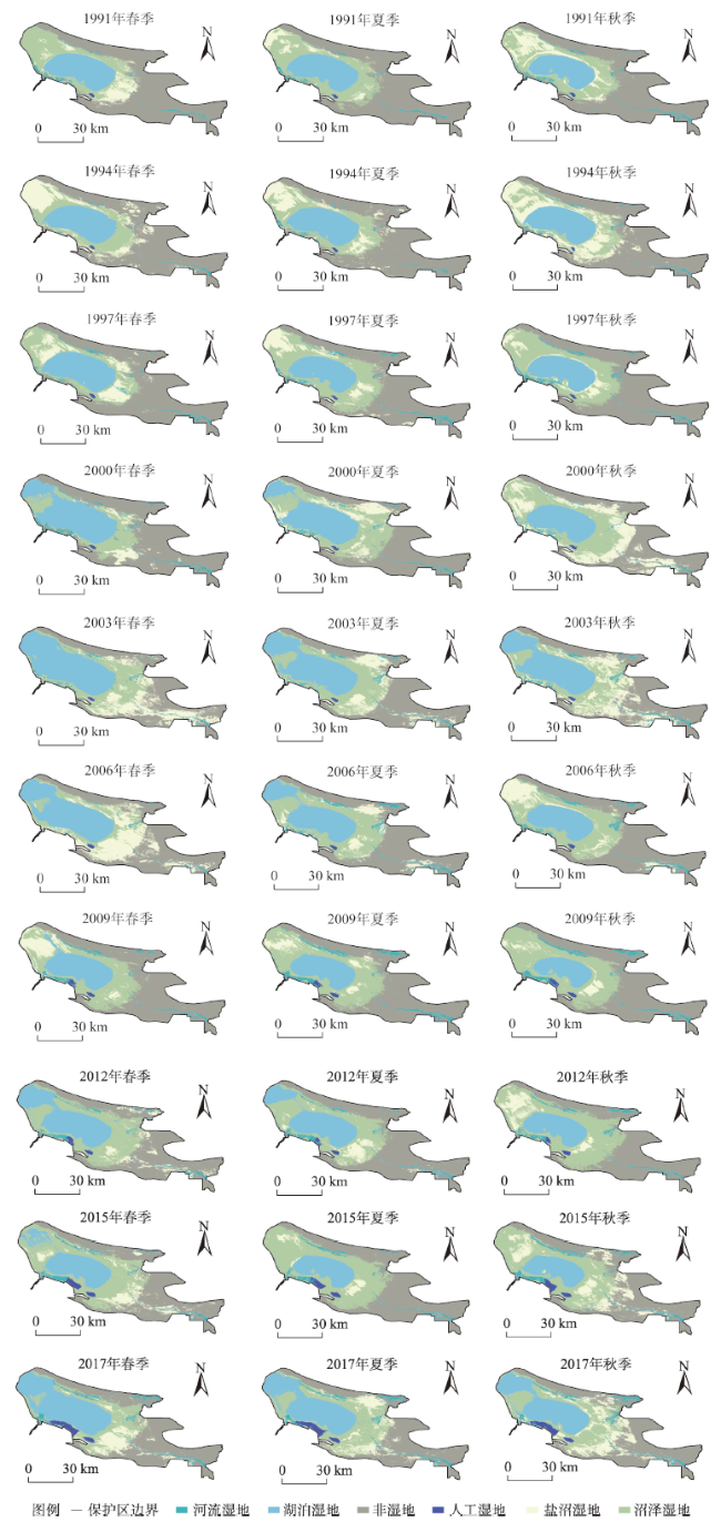
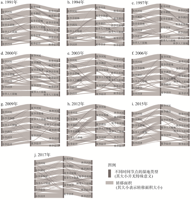
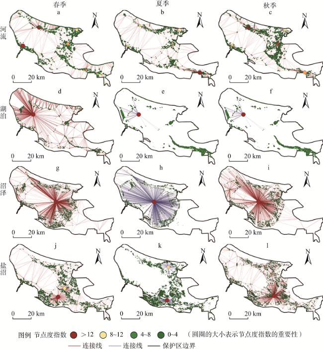
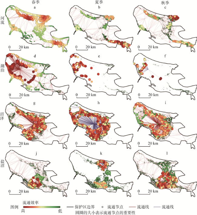
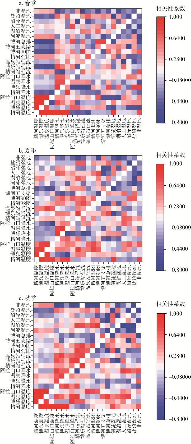
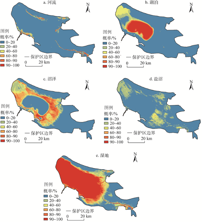
在资料稀缺的背景下,遥感数据是提供湿地系统长时间序列的理想方案。然而面向“一带一路”沿线地区复杂下垫面,国家级湿地缺乏系统的长时序梳理。利用Landsat系列数据,基于随机森林分类模型,研究近30年中国典型尾闾湖湿地的时空分布模式、空间转换规律和景观连通性。结果表明:随机森林算法在艾比湖湿地分类应用中取得较高精度(Kappa系数大于0.9)。1991—2017年艾比湖湿地总面积增加425.06 km2,河流增加47.97 km2,湖泊增加233.95 km2,人工湿地增加48.74 km2,盐沼增加109.41 km2,沼泽减少15.01 km2。艾比湖湿地年内时空变化显著,年内季节间盐沼转化率最大,湖泊年内逐渐缩小,主要转化为沼泽。此外,艾比湖湿地空间连通性理想度排序为:春季>夏季>秋季,湿地景观连通性取决于较大面积的湿地斑块,连通效率东移。相关结果可弥补稀缺资料区基础湿地资料,为“一带一路”地区生态补水长效机制提供典型示范。
丁建丽 , 葛翔宇 , 王敬哲 . 中国艾比湖湿地识别及其时空动态变化[J]. 自然资源学报, 2021 , 36(8) : 1949 -1963 . DOI: 10.31497/zrzyxb.20210804
Remote sensing data can provide long-term sequences for replenishing wetlands in changing environments under the context of scarce data. The accurate identification of wetland systems in arid regions is important to the comprehensive regulation and feedback mechanism of water and soil resources. However, we lack long-term data accumulation in the national wetlands in the context of the complex underlying surface of the Belt and Road region. In this study, random forest (RF) classification model was used to map the spatial distribution pattern of the typical terminal lake wetland in the arid regions over the past 30 years. Through the accurate wetland mapping, the spatial conversion rule of the wetland landscape is calculated, and the spatial connectivity of the wetland landscape is determined. We present the results of a high-precision classification study conducted in the Ebinur Lake National Wetland Reserve (Kappa coefficient is greater than 0.9). The spatial and temporal changes in the Ebinur Lake wetland during 1991-2017 was extremely significant, especially in different seasons of the year. From 1991 to 2017, the total area of wetlands, rivers, lakes, constructed wetlands, and salt marshes increased by 425.06 km2, 47.97 km2, 233.95 km2, 48.74 km2, and 109.41 km2, respecctively, while the total area of marshes decreased by 15.01 km2. The annual change in salt marsh conversion is the largest, and the lake wetlands were shrinking gradually from spring to autumn, mainly into swampy wetlands. In addition, the ideal spatial connectivity of Ebinur wetland is listed in the order of spring > summer > autumn. The connectivity between lake wetlands, marsh wetlands and non-wetlands is better than that of other types of wetlands. The connectivity of wetland landscapes depends on the wetland patches with larger areas. To a certain extent, this research compensates the basic wetland data in the scarce data area, and provides a typical demonstration for the long-term mechanism of ecological water replenishment in the Belt and Road region.
Key words: wetland data extraction; random forest; time series; ecological effect
表1 艾比湖湿地分类体系及解译特征Table 1 Classification system and interpretation characteristics of Ebinur Lake wetland |
| 一级分类 | 二级分类 | 地表特征 | 光学影像特征 | 影像 | 照片 |
|---|---|---|---|---|---|
| 湿地 | 河流 | 河流,部分河岸多芦苇 | 红色与蓝黑色混杂,分布为条带状,由植被像元和河流像元混交 |  |  |
| 湖泊 | 艾比湖 | 深蓝色,明显的湖岸线 | |||
| 人工湿地 | 主要为盐场 | 规则矩形的盐渍化地表和水体 | |||
| 沼泽 | 因湖泊季节性扩缩露出的滩地 | 呈浅蓝色,零星分布的水体像元与浅蓝色土壤像元 | |||
| 盐沼 | 地表有明显盐渍化现象 | 呈白色,零散分布白色或连片分布 | |||
| 非湿地 | 非湿地 | 主要为裸露的土地、荒漠草本植物 | 棕灰色,连片分布 |
图9 2017年艾比湖湿地保护区不同湿地类型的NDI的变化Fig. 9 Changes in NDI of different wetland patches in Ebinur Lake wetland in different seasons of 2017 |
图10 2017年艾比湖湿地保护区不同湿地类型的FI的变化Fig. 10 Changes in FI of different patches in Ebinur Lake wetland in different seasons of 2017 |
| [1] |
|
| [2] |
|
| [3] |
|
| [4] |
|
| [5] |
陈亚宁, 李稚, 范煜婷, 等. 西北干旱区气候变化对水文水资源影响研究进展. 地理学报, 2014, 69(9): 1295-1304.
[
|
| [6] |
杨胜天, 于心怡, 丁建丽, 等. 中亚地区水问题研究综述. 地理学报, 2017, 72(1): 79-93.
[
|
| [7] |
|
| [8] |
吕金霞, 蒋卫国, 王文杰, 等. 近30年来京津冀地区湿地景观变化及其驱动因素. 生态学报, 2018, 38(12): 4492-4503.
[
|
| [9] |
|
| [10] |
|
| [11] |
|
| [12] |
|
| [13] |
穆博, 李华威,
[
|
| [14] |
|
| [15] |
|
| [16] |
葛翔宇, 丁建丽, 王敬哲, 等. 基于竞争适应重加权采样算法耦合机器学习的土壤含水量估算. 光学学报, 2018, 38(10): 393-400.
[
|
| [17] |
齐雁冰, 王茵茵, 陈洋, 等. 基于遥感与随机森林算法的陕西省土壤有机质空间预测. 自然资源学报, 2017, 32(6): 1074-1086.
[
|
| [18] |
|
| [19] |
|
| [20] |
|
| [21] |
谭娇, 丁建丽, 董煜, 等. 新疆艾比湖绿洲潜在蒸散量年代际变化特征. 农业工程学报, 2017, 33(5): 143-148.
[
|
| [22] |
张喆, 丁建丽, 王瑾杰. 中亚沙尘气溶胶时空分布特征及潜在扩散特性分析. 地理学报, 2017, 72(3): 507-520.
[
|
| [23] |
|
| [24] |
|
| [25] |
荔琢, 蒋卫国, 王文杰, 等. 基于生态系统服务价值的京津冀城市群湿地主导服务功能研究. 自然资源学报, 2019, 34(8): 1654-1665.
[
|
/
| 〈 |
|
〉 |