
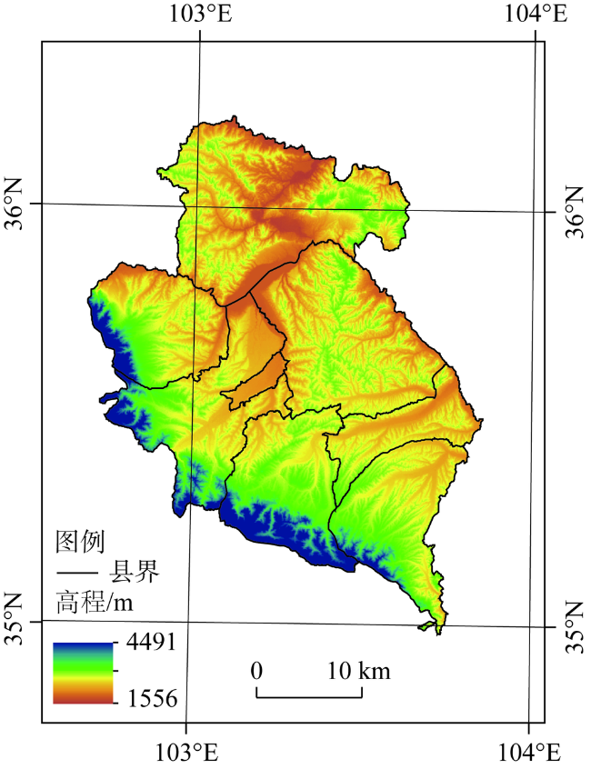
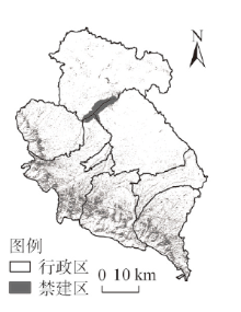
黄河上游生态脆弱区城市增长边界划定——以临夏回族自治州为例
|
杨雪荻(1995- ),女,甘肃兰州人,硕士,研究方向为区域发展与管理。E-mail:yxdlz01@163.com |
收稿日期: 2020-04-28
要求修回日期: 2020-11-16
网络出版日期: 2021-03-28
基金资助
国家自然科学基金项目(41701173)
甘肃省重点研发计划(18YF1FA052)
版权
Delimitation of urban growth boundary in ecologically vulnerable areas in the Upper Yellow River: Take Linxia Hui Autonomous Prefecture as an example
Received date: 2020-04-28
Request revised date: 2020-11-16
Online published: 2021-03-28
Copyright
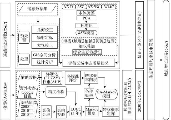
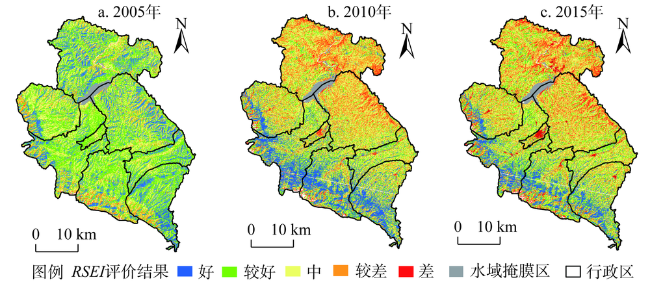
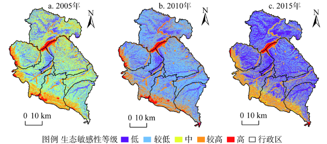
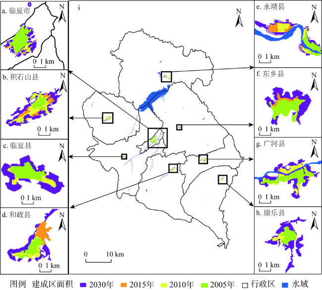
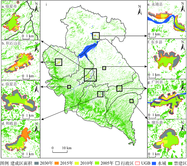
黄河流域是我国重要的生态屏障和经济区,其上游水源涵养区对黄河流域的生态可持续发展起着决定性的作用。因此,科学统筹城乡发展、合理划定城市增长边界(UGB),对于黄河流域生态保护与城市高质量发展具有重要意义。以黄河上游典型城市临夏回族自治州为研究对象,基于土地利用及相关遥感数据,运用遥感生态指数(RSEI)、生态敏感性分析评估了临夏回族自治州的生态质量,并在此基础上,结合CA-Markov对比分析了有无生态环境质量评价条件下未来城市增长边界发展情况。结果表明:(1)2005—2015年,临夏回族自治州生态环境整体较差且逐年下降,2015年生态质量(RSEI)结果降至最低(0.38)。同时,生态敏感性也从中度敏感变为低度敏感。(2)2005—2015年,研究区城市扩张面积增长6.04 km2,通过CA-Markov模拟得到的2030年城市建设用地规模为95.88 km2,超出规划面积3.2 km2,城市扩张未得到有效约束。(3)RSEI-CA-Markov模拟2030年的城市建设用地为90.36 km2,小于政府规划面积2.32 km2,符合城市可持续发展要求。因此,基于RSEI-CA-Markov划定的黄河上游生态脆弱地区UGB具有更强的城市管理能力,有利于引导和实现城市可持续发展,也可对中国其他生态脆弱城市生态—经济协调发展提供参考依据。
关键词: 黄河上游; 生态脆弱地区; RSEI-CA-Markov模型; 城市增长边界; 临夏回族自治州
杨雪荻 , 白永平 , 车磊 , 周亮 , 乔富伟 , 王治国 . 黄河上游生态脆弱区城市增长边界划定——以临夏回族自治州为例[J]. 自然资源学报, 2021 , 36(1) : 162 -175 . DOI: 10.31497/zrzyxb.20210111
The Yellow River Basin is an important ecological barrier and economic zone in China, and its upstream water-conserving areas play a decisive role in the sustainable ecological development of the Yellow River Basin. Therefore, scientific coordination of urban and rural development and reasonable delineation of urban growth boundary (UGB) are of great significance for ecological protection and high-quality urban development in the Upper Yellow River Basin. This paper takes Linxia, a typical prefecture-level city in the upper reaches of the Yellow River, as the research object, and assesses its ecological quality based on land use and related remote sensing data using remote sensing ecological index (RSEI) and ecological sensitivity analysis. On this basis, the future urban growth boundary development with and without ecological quality assessment conditions is analyzed in combination with CA-Markov comparison. The results show that: (1) From 2005 to 2015, the overall ecological environment of the study area was poor and decreased year by year, and the ecological quality (RSEI) result dropped to the lowest (0.38) in 2015. Meanwhile, the ecological sensitivity changed from moderate to low sensitivity. (2) The urban expansion area increased by 6.04 km2, and the scale of urban construction land in 2030 obtained by CA-Markov simulation was 95.88 km2, which exceeded the planned area by 3.2 km2, and the urban expansion was not effectively restrained. (3) Simulation of RSEI-CA-Markov shows that the urban construction land in 2030 is 90.36 km2, which is smaller than the planned government planning area of 3.3 km2, and meets the requirements of urban sustainable development. Based on this, the designated UGB has stronger urban management capabilities. The delineation of UGB in the ecologically fragile area in the Upper Yellow River is conducive to guiding and realizing sustainable urban development, which can also provide reference for the sustainable development of other ecologically fragile cities in China.
表1 遥感数据来源Table 1 Remote sensing data source |
| 参数 | 2005年7月 | 2010年8月 | 2015年8月 |
|---|---|---|---|
| 传感器类型 | TM | TM | OLI |
| 分辨率/m | 30 | 30 | 30 |
| 波段 | 1、2、3、4、5、6、7、8 | 1、2、3、4、5、6、7、8 | 1、2、3、4、5、6、7、8、9、10 |
| 云量/% | <5 | <5 | <5 |
表2 生态敏感性评价因子分级及权重Table 2 The grades and weights of ecological sensitivity factors |
| 生态因子 | 权重 | 生态敏感性分级 | ||||
|---|---|---|---|---|---|---|
| 极高敏感 | 高敏感 | 中敏感 | 低敏感 | 非敏感 | ||
| 坡度/(°) | 0.23 | >60 | 45~60 | 25~45 | 10~25 | 0~10 |
| 海拔/m | 0.20 | >1300 | 1000~1300 | 800~1000 | 500~800 | <500 |
| 植被覆盖度 | 0.27 | >0.5 | 0.4~0.3 | 0.2~0.3 | 0.1~0.2 | 0~0.1 |
| 河流水库距离/m | 0.12 | <50 | 50~100 | 100~150 | 150~200 | >200 |
| 地质灾害易发性 | 0.17 | 高易发区 | — | 中易发区 | 低易发区 | 不易发区 |
表3 RSEI各指标荷载值Table 3 Load values of RSEI indexes |
| 指标 | 2005年 | 2010年 | 2015年 | |||||
|---|---|---|---|---|---|---|---|---|
| 均值 | 荷载值 | 均值 | 荷载值 | 均值 | 荷载值 | |||
| WET | 0.388 | 0.217 | 0.413 | 0.341 | 0.440 | 0.291 | ||
| NDVI | 0.777 | 0.345 | 0.748 | 0.319 | 0.613 | 0.357 | ||
| LST | 0.579 | -0.579 | 0.617 | -0.609 | 0.578 | -0.644 | ||
| NDSI | 0.531 | -0.631 | 0.513 | -0.637 | 0.487 | -0.621 | ||
| RSEI | 0.401 | 0.397 | 0.382 | |||||
| [1] |
王亚飞, 樊杰, 周侃. 基于“双评价”集成的国土空间地域功能优化分区. 地理研究, 2019,38(10):2415-2429.
[
|
| [2] |
龙花楼, 刘永强, 李婷婷, 等. 生态文明建设视角下土地利用规划与环境保护规划的空间衔接研究. 经济地理, 2014,34(5):1-8.
[
|
| [3] |
彭建, 赵会娟, 刘焱序, 等. 区域生态安全格局构建研究进展与展望. 地理研究, 2017,36(3):407-419.
[
|
| [4] |
吴大放, 胡悦, 刘艳艳, 等. 城市开发强度与资源环境承载力协调分析: 以珠三角为例. 自然资源学报, 2020,35(1):82-94.
[
|
| [5] |
徐文彬, 尹海伟, 孔繁花. 基于生态安全格局的南京都市区生态控制边界划定. 生态学报, 2017,37(12):4019-4028.
[
|
| [6] |
苏伟忠, 马丽雅, 陈爽, 等. 城市生态空间冲突分析与系统优化方法. 自然资源学报, 2020,35(3):601-613.
[
|
| [7] |
丛佃敏, 赵书河, 于涛, 等. 综合生态安全格局构建与城市扩张模拟的城市增长边界划定: 以天水市规划区(2015—2030年)为例. 自然资源学报, 2018,33(1):14-26.
[
|
| [8] |
|
| [9] |
刘辉, 张志赟, 税伟, 等. 资源枯竭型城市增长边界划定研究: 以淮北市为例. 自然资源学报, 2017,32(3):391-405.
[
|
| [10] |
|
| [11] |
王旭, 马伯文, 李丹, 等. 基于FLUS模型的湖北省生态空间多情景模拟预测. 自然资源学报, 2020,35(1):230-242.
[
|
| [12] |
|
| [13] |
张学儒, 周杰, 李梦梅. 基于土地利用格局重建的区域生境质量时空变化分析. 地理学报, 2020,75(1):160-178.
[
|
| [14] |
成超男, 胡杨, 冯尧, 等. 基于CA-Markov模型的城市生态分区构建研究: 以晋中主城区为例. 生态学报, 2020,40(4):1455-1462.
[
|
| [15] |
|
| [16] |
邱思齐, 岳文泽. 刚性与弹性相结合的城市开发边界划定: 以浙江省义乌市为例. 应用生态学报, 2018,29(5):1607-1616.
[
|
| [17] |
高晓路, 吴丹贤, 周侃, 等. 国土空间规划中城镇空间和城镇开发边界的划定. 地理研究, 2019,38(10):2458-2472.
[
|
| [18] |
赵越, 罗志军, 曹丽萍, 等. 基于空间决策的区域城镇发展与农业生产协调布局优化: 以江西省临川区为例. 自然资源学报, 2019,34(3):526-538.
[
|
| [19] |
|
| [20] |
|
| [21] |
邓元杰, 姚顺波, 侯孟阳, 等. 退耕还林还草工程对生态系统碳储存服务的影响: 以黄土高原丘陵沟壑区子长县为例. 自然资源学报, 2020,35(4):826-844.
[
|
| [22] |
|
| [23] |
|
| [24] |
杭鑫, 罗晓春, 曹云, 等. 基于RSEI模型的生态质量评估及城镇化影响: 以南京市为例. 应用生态学报, 2020,31(1):219-229.
[
|
| [25] |
|
| [26] |
|
| [27] |
|
/
| 〈 |
|
〉 |