
生态文明视角下的国土空间底线管控:“双评价”与国土空间规划监测评估预警
钟镇涛(1993- ),男,新疆库尔勒人,硕士,高级大数据工程师,研究方向为国土空间规划大数据挖掘与应用。E-mail: zztoozzt@qq.com
收稿日期: 2020-05-06
要求修回日期: 2020-08-03
网络出版日期: 2020-12-28
基金资助
国家自然科学基金项目(41871318)
广东省国土空间规划“一张图”建设关键技术研究项目(GDZRZYKJ2020007)
羊城创新创业领军人才支持计划(2019016)
Territorial space baseline control from the perspective of ecological civilization: "Double evaluation" and monitoring-evaluation-warning
Received date: 2020-05-06
Request revised date: 2020-08-03
Online published: 2020-12-28
Copyright
生态文明新时代下的空间规划体系对国土空间底线管控提出了明确要求,“双评价”与国土空间规划监测评估预警是底线思维的体现。研究“双评价”与国土空间规划监测评估预警在国土空间底线管控中的作用和地位,通过国土空间规划“一张图”实施监督信息系统的建设,对二者的联系及其相互作用进行体现,构建二者的联动方式,服务于国土空间底线管控及治理的全过程。“双评价”与国土空间规划监测评估预警共同组成底线管控的两个阶段,前者是开展底线管控的基础,后者是底线管控的路径和手段,两者皆是生态文明新时代下国土空间规划底线管控的重要工具,需以国土空间规划“一张图”实施监督信息系统为基础加强两者的有机结合。
钟镇涛 , 张鸿辉 , 洪良 , 刘耿 , 罗伟玲 . 生态文明视角下的国土空间底线管控:“双评价”与国土空间规划监测评估预警[J]. 自然资源学报, 2020 , 35(10) : 2415 -2427 . DOI: 10.31497/zrzyxb.20201009
The national spatial planning system in the new era of ecological civilization has put forward targeted requirements for the baseline control of territorial space. Both of "double evaluation" and monitoring-evaluation-warning of national spatial planning are the embodiment of baseline thinking. In this paper, the inner relationship between "double evaluation" and monitoring-evaluation-warning of national spatial planning was studied based on the "one map" implementation supervision information system ("one map system") of national spatial planning. The path of territorial space control and governance is constructed (1) to study the role and status of "double evaluation" and monitoring-evaluation-warning of national spatial planning in the territorial space baseline control. The connection and interaction between the two are reflected through the construction of "one map system", which builds a linkage between the two for supporting the whole process of territorial space baseline control and governance. (2) It is found that the work of "double evaluation" focuses on the analysis of natural resources endowment and the identification of the current situation of territorial space, while monitoring-evaluation-warning is dynamic and continuous, which focuses on the long-term dynamic monitoring and timely early warning of various spatial elements. Both of them constitute two stages of baseline control. The former is the basis and the latter is the path and means for baseline control. (3) The practice of national spatial planning of Pingdingshan in Henan province confirmed that "one map system" is helpful as well as necessary for supporting "double evaluation" and monitoring-evaluation-warning. On the one hand, the scientificity of the planning compilation could be improved under the support of "double evaluation". On the other hand, the process of planning implementation could also be effectively regulated by sophisticated monitoring-evaluation-warning system. (4) Both of "double evaluation" and monitoring-evaluation-warning are important tools for territorial space baseline control in the new era of ecological civilization. It is necessary to strengthen the organic combination of the two based on the "one map system".
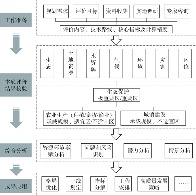
Fig. 1 The flow chart of "double evaluation"图1 “双评价”工作流程 |
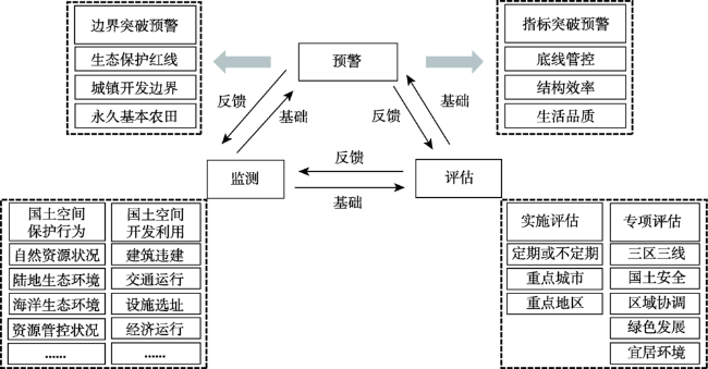
Fig. 2 Relationship of monitoring-evaluation-warning图2 监测评估预警逻辑关系 |
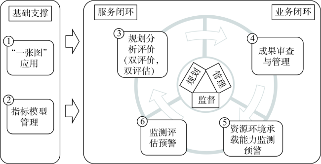
Fig. 3 Operating mechanism of "one map system"图3 国土空间规划“一张图”实施监督信息系统运作机制 |
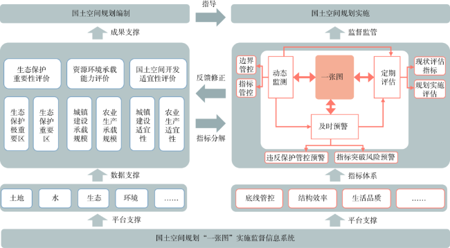
Fig. 4 Relationship between "double evaluation" and monitoring-evaluation-warning图4 “双评价”与监测评估预警关联关系 |
Table 1 Index decomposition of "three line" based on "double evaluation"表1 基于“双评价”的“三线”指标分解 |
| “双评价”成果 | “三线”类别 | 指标分解 |
|---|---|---|
| 生态保护 极重要区 | 生态保护红线 | 生态保护红线面积 |
| 基本生态控制线 | ||
| 历史遗留矿山地质环境恢复 治理面积 | ||
| 生态空间内的开发强度 | ||
| …… | ||
| 农业生产 适宜区 | 永久基本农田 保护线 | 永久基本农田面积 |
| 农业空间内的开发强度 | ||
| 耕地保有量 | ||
| 高标准基本农田面积 | ||
| …… | ||
| 城镇建设 适宜区 | 城镇开发边界 | 城镇开发边界面积 |
| 城镇空间内的开发强度 | ||
| …… |
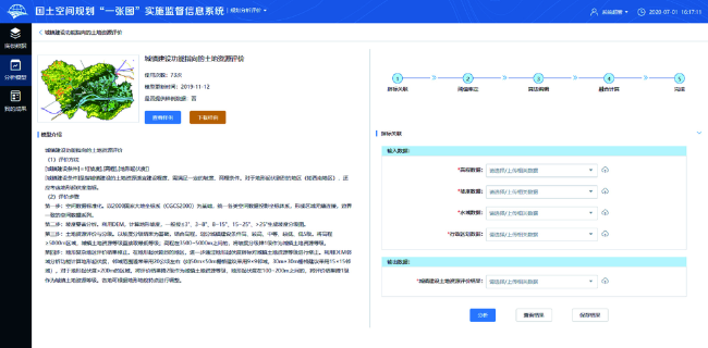
Fig. 5 Function interface of "double evaluation" in "one map system" (basic data)图5 “一张图系统”“双评价”功能界面(底板数据) |
Fig. 6 Function interface of "double evaluation" in "one map system" (analysis model)图6 “一张图系统”“双评价”功能界面(分析模型) |
Fig. 7 Function interface of "double evaluation" in "one map system" (my results)图7 “一张图系统”“双评价”功能界面(我的成果) |
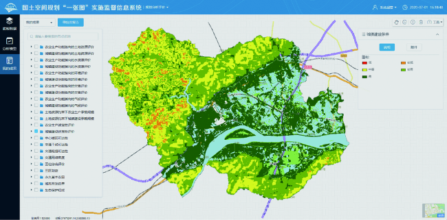
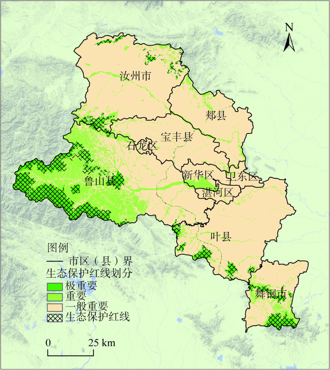
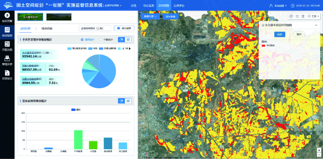
Fig. 8 Ecological redline delineation results of Pingdingshan图8 平顶山市生态保护红线划定成果 |
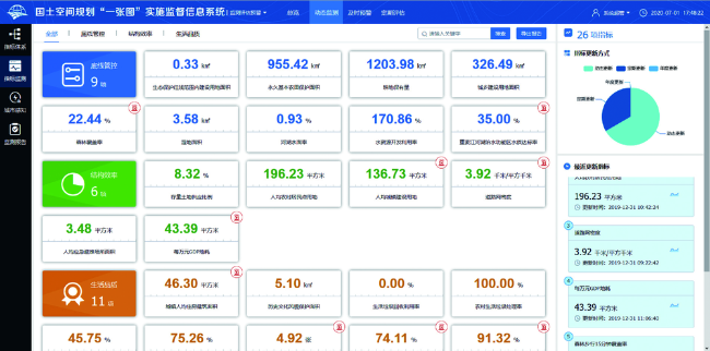
Fig. 9 Function interface of monitoring-evaluation-warning in "one map system" (dynamic monitoring)图9 “一张图系统”监测评估预警功能界面(动态监测) |
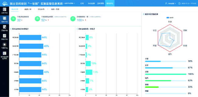
Fig. 10 Function interface of monitoring-evaluation-warning in "one map system" (early warning)图10 “一张图系统”监测评估预警功能界面(及时预警) |
Fig. 11 Function interface of monitoring-evaluation-warning in "one map system" (regular assessment)图11 “一张图系统”监测评估预警功能界面(定期评估) |
| [1] |
[
|
| [2] |
[
|
| [3] |
[
|
| [4] |
[
|
| [5] |
[
|
| [6] |
[
|
| [7] |
[
|
| [8] |
[
|
| [9] |
[
|
| [10] |
中华人民共和国中央人民政府. 中共中央国务院关于建立国土空间规划体系并监督实施的若干意见. , 2019-05-23.
[The Central People's Government of the PRC. Several opinions of t-he central committee of the Communist Party of China on establishing a land and space planning system and supervisin-g implementation. .]
|
| [11] |
中华人民共和国自然资源部. 关于开展国土空间规划“一张图”建设和现状评估工作的通知. , 2019-07-26.
[Ministry of Natural Resources of the PRC. Notice on carrying out "one map" construction and current situation evaluation of land and space planning. , 2019-07-26.]
|
| [12] |
[
|
| [13] |
[
|
| [14] |
[
|
| [15] |
[
|
| [16] |
[
|
| [17] |
[
|
| [18] |
[
|
| [19] |
[
|
| [20] |
[
|
| [21] |
[
|
| [22] |
中华人民共和国自然资源部. 资源环境承载能力和国土空间开发适宜性评价技术指南(试行). , 2020-01-19.
[Ministry of Natural Resources of the PRC. Technical guide for assessment of resour-ces and environment carrying capacity and suitability of land and space development (Trial). , 2020-01-19.]
|
| [23] |
[
|
| [24] |
[
|
| [25] |
[
|
| [26] |
中华人民共和国自然资源部. 自然资源部信息化建设总体方案. , 2019-11-01.
[Ministry of Natural Resources of the PRC. General plan for informatization construction of the ministry of natural resources. , 2019-11-01.]
|
/
| 〈 |
|
〉 |
