
基于“双评价”的城镇开发边界划定技术——以湘潭县中心城区为例
项广鑫(1988- ),男,内蒙古赤峰人,硕士,工程师,主要从事资源环境与国土空间规划研究。E-mail: csuxiang@qq.com
收稿日期: 2020-02-15
要求修回日期: 2020-05-12
网络出版日期: 2020-12-28
基金资助
湖南创新型省份建设专项(2019SK2101)
Demarcation technology of urban development boundary based on evaluation of carrying capacity of resources environment and suitability of land space development: A case study of the central city of Xiangtan county
Received date: 2020-02-15
Request revised date: 2020-05-12
Online published: 2020-12-28
Copyright
构建“生态—农业—建设综合统筹”的城镇开发边界划定技术模型,即按“短板理论”计算空间约束下的县域建设开发建议规模,按指标权重计算综合得分进行国土空间开发适宜性评价,按生态优先、耕地保护优先原则确定地块规划功能,结合城镇建设现状、社会经济发展和城乡协调发展等因素划定城镇开发边界。以湘潭县中心城区为例进行实证,划定城镇开发边界4500 hm2。结果表明:与湘潭县土地利用总体规划规模边界、城市总体规划中心城区空间增长边界相比,本次划定的城镇开发边界中生态极重要或极敏感区域由3.49%、12.46%降为0,新增建设用地占用耕地的比例由53.26%、50.94%降低到21.02%,新增建设用地年均增速相比降低了45.65%。该技术模型对优化国土空间开发利用保护布局,促进绿色发展、高质量发展起到了积极作用。
项广鑫 , 符金豪 , 曾丽婷 , 蒋星祥 , 曾毅 . 基于“双评价”的城镇开发边界划定技术——以湘潭县中心城区为例[J]. 自然资源学报, 2020 , 35(10) : 2401 -2414 . DOI: 10.31497/zrzyxb.20201008
To construct the model of "Ecology-Agriculture-Construction Comprehensive Planning" for delimitation techniques of urban development boundary, this paper calculates the proposed scale of county construction and development under spatial constraints based on "Short Board Theory", evaluates the suitability of land space development by calculating the comprehensive score according to the index weight, determines the land plot planning function and identifies construction priority areas in accordance with the principle of ecological priority and cultivated land protection priority. Then on these bases, the urban development boundary shall be delimited according to the urban construction conditions, laws and regulations, social and economic development, urban and rural coordinated development and other factors, with the priority areas as the base map and the scale of urban construction land as the basis. Through the empirical research on the central area of Xiangtan county, the urban development boundary of 4500 hectares has been determined. Compared with the scale boundary of the land-use master plan and the spatial growth boundary of the central district of the urban master plan, the technical model fully considers the restrictive effects of ecological environment, land resources, water resources, natural disasters and other factors on construction and development. The ecologically important or sensitive areas in the urban development boundary have been reduced from 3.49%, 12.46% to 0. The proportion of cultivated land occupied by new construction has been reduced from 53.26%, 50.94% to 21.02%, without occupying permanent basic farmland and ecological forests. The average annual growth rate of new construction land has been reduced by 45.65%, which is divided into or radiated into the concentrated area of village distribution. There are some problems in the traditional methods, such as determining the scale of construction land in the light of the development needs without considering the constraints of resources and environment on urban development, and ignoring the multiple suitability of land, etc. The research result shows that the technical model proposed in this paper makes up for the above shortcomings, so as to realize the priority of ecology and farmland protection, and promote conservation and intensive land use and urban-rural coordinated development. In addition, it can play a positive role in optimizing the layout of land space development, utilization and protection, and boosting green and high-quality development.
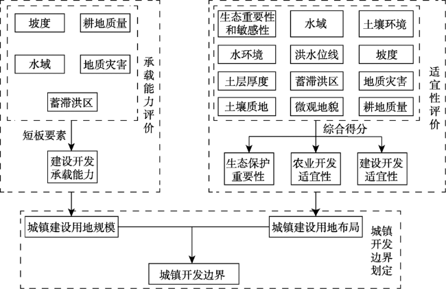
Fig. 1 Technology roadmap of urban development boundary demarcation based on evaluations of carrying capacity of resources environment and suitability of land space development图1 基于“双评价”的城镇开发边界划定技术路线 |
Table 1 Index and classification standard of land resources availability in construction development表1 建设开发承载能力评价指标和分级标准 |
| 指标 | 指标分类 | 分级 |
|---|---|---|
| 坡度/(°) | >25 | 低(Ⅰ级) |
| (15, 25] | 较低(Ⅱ级) | |
| (8, 15] | 中(Ⅲ级) | |
| (0, 8] | 高(Ⅴ级) | |
| 水域 | 河流、湖泊、水库等 | 低(Ⅰ级) |
| 耕地质量 | 耕地质量劣于评价区域平均利用等 | 中(Ⅲ级) |
| 耕地质量优于评价区域平均利用等 | 较低(Ⅱ级) | |
| 地质灾害易发程度 | 高易发区 | 较低(Ⅱ级) |
| 中易发区 | 中(Ⅲ级) | |
| 低易发区 | 较高(Ⅳ级) | |
| 其他 | 高(Ⅴ级) | |
| 蓄滞洪区 | 蓄滞洪区范围内 | 低(Ⅰ级) |
Table 2 Factors of suitability evaluation of agricultural production表2 农业生产适宜性评价指标体系 |
| 类型 | 指标 | 指标分类 | 分值(J农i、X农k) | 权重(w农k) |
|---|---|---|---|---|
| 禁止性 指标 | 生态重要性和敏感性 | 生态极重要或极敏感区域 | 0 | |
| 其他 | 1 | |||
| 水域 | 河流、湖泊、水库等 | 0 | ||
| 其他 | 1 | |||
| 土壤环境 | 劣于农用地土壤污染风险管制值 [按《土壤环境质量—农用地土壤污染风险管控标准(试行)》(GB15618-2018)] | 0 | ||
| 优于农用地土壤污染风险管制值 [按《土壤环境质量—农用地土壤污染风险管控标准(试行)》(GB15618-2018)] | 1 | |||
| 水环境 | 劣于农田灌溉用水水质基本控制项目标准值 [按《农田灌溉水质标准》(GB5084-2005)] | 0 | ||
| 优于农田灌溉用水水质基本控制项目标准值 [按《农田灌溉水质标准》(GB5084-2005)] | 1 | |||
| 洪水位线 | 河流、湖泊洪水位线以下 | 0 | ||
| 河流、湖泊洪水位线以上 | 1 | |||
| 坡度/(°) | >25 | 0 | ||
| 土层厚度/cm | <30 | 0 | ||
| 限制性 指标 | 生态重要性和敏感性 | 高度重要或高度敏感 | 20 | 0.2 |
| 中等重要或中度敏感 | 60 | |||
| 一般重要/不重要或一般敏感/不敏感 | 100 | |||
| 坡度/(°) | (15, 25] | 20 | 0.2 | |
| (8, 15] | 60 | |||
| (2, 8] | 80 | |||
| [0, 2] | 100 | |||
| 蓄滞洪区 | 重要蓄滞洪区 | 30 | 0.1 | |
| 一般蓄滞洪区 | 50 | |||
| 蓄滞洪保留区 | 70 | |||
| 非蓄滞洪区 | 100 | |||
| 地质灾害易发程度 | 高易发区 | 60 | 0.05 | |
| 中易发区 | 80 | |||
| 低易发区 | 90 | |||
| 其他 | 100 | |||
| 土层厚度/cm | [30, 60) | 60 | 0.15 | |
| [60, 90) | 80 | |||
| ≥ 90 | 100 | |||
| 土壤质地 | 砾质土 | 10 | 0.2 | |
| 壤质砂土、砂质壤土、砂质粘土、壤质粘土、粉砂质粘土、粘土 | 50 | |||
| 壤土、粉砂质壤土、砂质粘壤土、粘壤土、粉砂质粘壤土 | 100 | |||
| 微观地貌 | 山肩、山顶 | 10 | 0.1 | |
| 背坡 | 30 | |||
| 麓坡 | 60 | |||
| 趾坡、岗地 | 90 | |||
| 平原、台地 | 100 |
Table 3 Factors of suitability evaluation of construction development表3 建设开发适宜性评价指标体系 |
| 类型 | 指标 | 分类 | 分值(J建i、X建k) | 权重 |
|---|---|---|---|---|
| 禁止性 指标 | 生态重要性和敏感性 | 生态极重要或极敏感区 | 0 | |
| 其他区域 | 1 | |||
| 水域 | 河流、湖泊、水库等 | 0 | ||
| 其他 | 1 | |||
| 洪水位线 | 河流、湖泊洪水位线以下 | 0 | ||
| 河流、湖泊洪水位线以上 | 1 | |||
| 坡度/(°) | >25 | 0 | ||
| 限制性 指标 | 生态重要性和敏感性 | 高度重要或高度敏感 | 30 | 0.4 |
| 中等重要或中度敏感 | 60 | |||
| 一般重要或一般敏感 | 100 | |||
| 耕地质量 | 耕地质量高于评价区域平均利用等 | 20 | 0.25 | |
| 耕地质量低于评价区域平均利用等 | 60 | |||
| 坡度 | 大于25%,且小于等于46.63%(25°) | 10 | 0.25 | |
| ≤ 25% | 100 | |||
| 地质灾害易发程度 | 高易发区 | 40 | 0.05 | |
| 中易发区 | 60 | |||
| 低易发区 | 80 | |||
| 无地质灾害风险 | 100 | |||
| 蓄滞洪区 | 蓄滞洪区 | 20 | 0.05 | |
| 其他 | 100 |
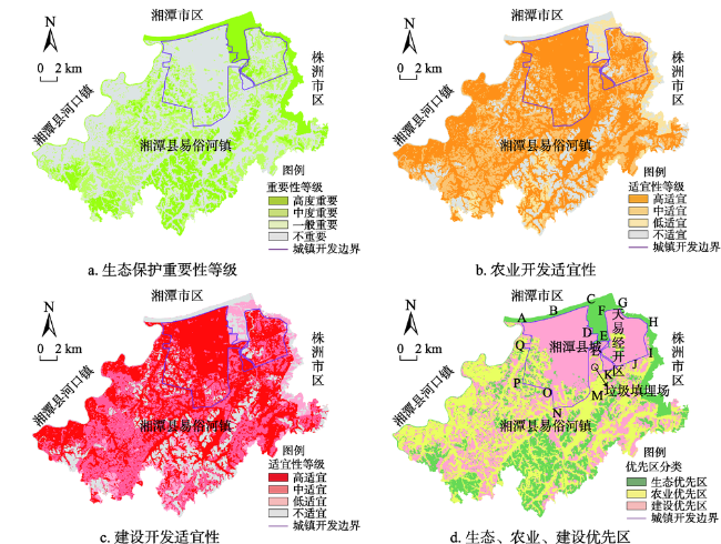
Fig. 2 Suitability distribution of land space development and priority areas of ecology, agriculture and construction in Yisuhe town, Xiangtan county图2 湘潭县易俗河镇国土空间开发适宜性分布及三大地类优先区 |
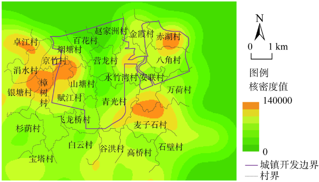
Fig. 3 Village kernel density and urban development boundary of the central city of Xiangtan图3 湘潭县中心城区城镇开发边界与村庄核密度分析 |
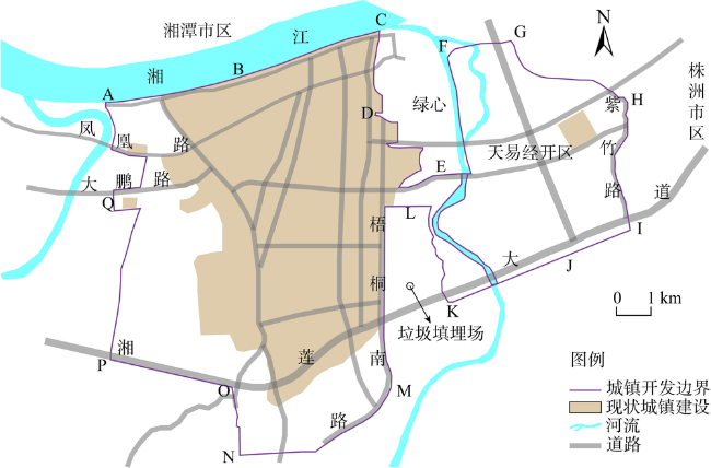
Fig. 4 The relationship between urban development boundary and the current urban construction, river and road location in the central city of Xiangtan图4 湘潭县中心城区城镇开发边界与现状城镇建设、河流、道路位置关系 |
Table 4 The structure of new construction land occupation within the control boundaries of construction and development in the central city of Xiangtan (%)表4 湘潭县中心城区建设开发控制性边界内新增建设用地占用地类结构 |
| 边界内新增建设 用地占用地类 | 土地利用总体规划 规模边界 | 城市总体规划中心城区 空间增长边界 | 国土空间规划城镇 开发边界 |
|---|---|---|---|
| 林地 | 30.08(含公益林) | 29.42(含公益林) | 49.72(全部为非公益林) |
| 耕地 | 53.26 | 50.94(含永久基本农田) | 21.02 |
| 园地 | 0.17 | 0.29 | 0.26 |
| 采矿用地 | 0.92 | 1.22 | 3.64 |
| 坑塘水面 | 8.71 | 8.64 | 12.57 |
| 其他类型的土地 | 6.85 | 9.49 | 12.79 |
| [1] |
[
|
| [2] |
[
|
| [3] |
[
|
| [4] |
[
|
| [5] |
[
|
| [6] |
[
|
| [7] |
[
|
| [8] |
[
|
| [9] |
[
|
| [10] |
[
|
| [11] |
[
|
| [12] |
[
|
| [13] |
[
|
| [14] |
[
|
| [15] |
[
|
| [16] |
[
|
| [17] |
[
|
| [18] |
[
|
| [19] |
[
|
| [20] |
[
|
| [21] |
[
|
/
| 〈 |
|
〉 |