
智能技术辅助的市(县)国土空间规划编制研究
作者简介:孔宇(1991- ),男,山东日照人,硕士,研究方向为智慧规划。E-mail: 1518455319@qq.com
收稿日期: 2019-04-10
要求修回日期: 2019-08-02
网络出版日期: 2019-10-28
基金资助
国家自然科学基金项目(41571146,51708276,41701178)
中国博士后科学基金项目(2019M651784)
Research on smart technology-assisted territorial spatial planning: A case study at city and county level
Received date: 2019-04-10
Request revised date: 2019-08-02
Online published: 2019-10-28
Copyright
智慧社会的出现与发展影响着人地关系,而智能技术作为智慧社会崛起的主要动力与发展的重要支撑,正在改变着国土空间的保护、开发与治理模式,也对国土空间规划编制方法提出了新要求。当前规划编制中,智能技术在国土空间规划中的应用虽然已经有了一定的探索,在技术层面也有很多实践,但缺少对智能技术应用于国土空间规划的整体性思考。基于“生态文明”基础与“以人为本”的核心理念,在对传统规划编制与当前智能技术应用梳理的基础上,从智能感知与收集、智能分析与处理、智能评估和智能决策四个方面,系统地构建全流程的智能技术辅助国土空间规划编制的框架,以适应当前国土空间规划提出的新要求,辅助编制更合理、科学、智慧的方案。
孔宇 , 甄峰 , 李兆中 , 傅行行 . 智能技术辅助的市(县)国土空间规划编制研究[J]. 自然资源学报, 2019 , 34(10) : 2186 -2199 . DOI: 10.31497/zrzyxb.20191014
The emergence and development of the e-society affect the relationship between man and land. Smart technology, as one of the main driving forces and an important support for the rise of the e-society, is changing the mode of protection, development and governance of territorial space. It also puts forward new requirements for the compilation method of territorial spatial planning. At present, the application of smart technology in territorial spatial planning has been explored, and there are many practices at the technical level, but there is a lack of holistic thinking on the application of smart technology in territorial spatial planning. Based on the core concept of "ecological civilization" and "people-oriented", and on the basis of combing the traditional planning and the current application of smart technology, this paper systematically constructs a framework of the whole process of smart technology-assisted territorial spatial planning from four aspects: smart perception and collection, smart analysis and processing, smart evaluation and smart decision-making, so as to adapt to the current territorial spatial planning. To meet the new requirements, it is more reasonable, scientific and wise to assist in territorial spatial planning.
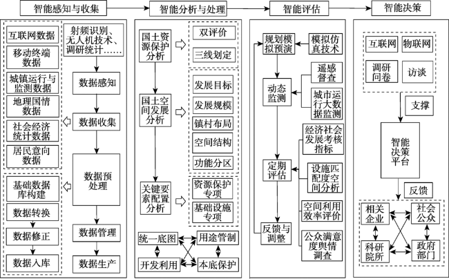
Fig. 1 The framework of city (county) territorial spatial planning driven by smart technology图1 智能技术驱动下的市(县)国土空间规划编制框架 |
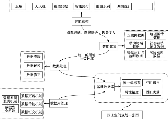
Fig. 2 The framework of smart perception and collection图2 智能感知与收集框架 |
Table 1 Data classification表1 数据分类 |
| 可获取多源数据 | 数据细分 | 数据获取方式 | 数据用途 |
|---|---|---|---|
| 互联网数据 | POI数据 | 网站 | 城镇空间结构、城镇功能分区 |
| 微博微信签到数据 | 网站 | 区域联系、区域关注度、活动类型、活动强度、活动范围 | |
| 舆情文本数据 | 网站 | 区域关注度、居民意愿反应 | |
| 主题网站数据 | 网站 | 区域联系、区域关注度 | |
| 移动终端数据 | 手机信令数据 | 企业 | 区域联系、人口预测、城镇活动时空分布、城镇流动网络格局、活动边界 |
| 手机APP数据 | 网站 | 城镇空间结构、城镇功能分区 | |
| 交通GPS轨迹数据 | 企业/个人 | 区域联系、城镇空间结构、城镇活动时空分布、城镇流动网络格局、活动边界 | |
| 城镇运行与监测数据 | 传感器与视频监控数据 | 政府 | 承载力评价、三线划定、城镇空间结构、城镇功能分区 |
| 企业运行数据 | 企业 | 区域联系、城镇发展定位、城镇发展规模、城镇功能分区 | |
| 交通运行数据 | 政府 | 区域联系、城镇流动网络格局 | |
| 环境监测数据 | 政府 | 承载力评价 | |
| 地理国情数据 | 遥感数据 | 网站 | 承载力评价、三线划定、城镇空间结构、城镇功能分区、镇村体系布局 |
| 空间规划数据 | 政府 | 承载力评价、三线划定、城镇空间结构、城镇功能分区、镇村体系布局 | |
| 建筑数据 | 政府 | 城镇边界划定、镇村体系布局、城市功能分区 | |
| 社会经济统计数据 | 统计年鉴数据 | 政府 | 城镇发展目标与定位、城镇规模预测 |
| 政府公报数据 | 政府 | 城镇发展目标与定位、城镇规模预测 | |
| 居民意向数据 | 问卷调研 | 个人 | 三生空间划定、镇村体系布局、城镇定位、城镇功能分区 |
| 访谈 | 个人 | 三生空间划定、镇村体系布局、城镇定位、城镇功能分区 |
Table 2 Table of multi-source data integration and application in the process of city (county) territorial spatial planning表2 市(县)国土空间规划编制流程中多源数据集成应用表 |
| 规划编制流程 | 智能分析与处理模型库 | 多源数据 | 集成应用 | ||
|---|---|---|---|---|---|
| 智能分析与处理 | “双评价”模型 | 环境监测数据 | 遥感数据 | 资源环境承载力评价、开发适宜性评价 | |
| 空间规划数据 | |||||
| “三生空间”界定模型 | 城镇空间 | 手机信令数据 | 问卷调研数据 | 居民活动边界、类型、强度 | |
| 微博微信签到数据 | 访谈数据 | ||||
| 舆情文本数据 | 建筑数据 | ||||
| 交通GPS轨迹数据 | 遥感数据 | ||||
| POI数据 | 企业运行数据 | ||||
| 农业空间 | 遥感数据 | 访谈数据 | 农业空间边界划定 | ||
| 问卷调研数据 | 空间规划数据 | ||||
| 生态空间 | 环境监测数据 | 遥感数据 | 生态空间边界划定 | ||
| 空间规划数据 | 访谈数据 | ||||
| 城市发展目标与定位分析模型 | 手机信令数据 | 统计年鉴数据 | 区域流空间分析 | ||
| 微博微信签到数据 | 企业运行数据 | ||||
| 交通运行数据 | 空间规划数据 | ||||
| 舆情文本数据 | 问卷调研数据 | 区域关注度分析 | |||
| 城市规模预测模型 | 手机信令数据 | 统计年鉴数据 | 城市人口预测 | ||
| 手机信令数据 | 空间规划数据 | 城市发展方向判断、城市用地规模预测 | |||
| 遥感数据 | 交通运行数据 | ||||
| 镇村体系布局辅助分析模型 | 空间规划数据 | 访谈数据 | 村庄拆除、整治、合并 | ||
| 问卷调研数据 | 遥感数据 | ||||
| 城市空间结构规划辅助分析模型 | 交通GPS轨迹数据 | 手机信令数据 | 城市内部流动空间特征 | ||
| 微博微信签到数据 | |||||
| 问卷调研数据 | 舆情文本数据 | 城市居民意向空间结构 | |||
| 访谈数据 | |||||
| 城市功能区划分辅助分析模型 | 交通GPS轨迹数据 | 手机信令数据 | 居民活动边界、类型、强度 | ||
| 企业运行数据 | 统计年鉴数据 | ||||
| 空间规划数据 | 建筑数据 | ||||
| POI数据 | 问卷调研数据 | ||||
| 微博微信签到数据 | 访谈数据 | ||||
| 城市土地利用规划 | — | — | — | ||
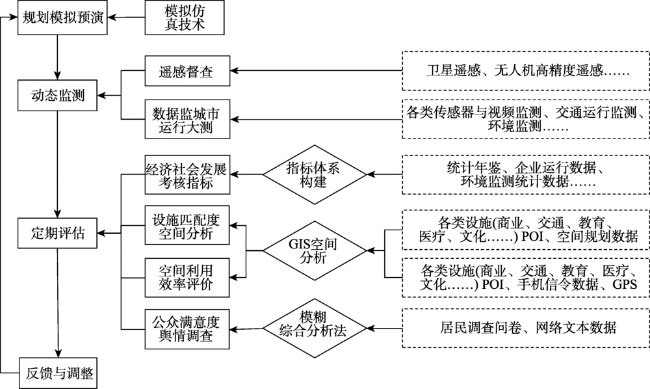
Fig. 3 The framework of smart evaluation图3 智能评估框架 |
Fig. 4 The framework of smart decision图4 智能决策框架 |
| [1] |
[
|
| [2] |
[
|
| [3] |
[
|
| [4] |
[
|
| [5] |
|
| [6] |
|
| [7] |
|
| [8] |
[
|
| [9] |
[
|
| [10] |
[
|
| [11] |
[
|
| [12] |
[
|
| [13] |
[
|
| [14] |
[
|
| [15] |
[
|
| [16] |
[
|
| [17] |
[
|
| [18] |
[
|
| [19] |
[
|
| [20] |
[
|
| [21] |
[
|
| [22] |
[
|
| [23] |
[
|
| [24] |
[
|
| [25] |
[
|
| [26] |
[
|
| [27] |
[
|
| [28] |
[
|
| [29] |
[
|
| [30] |
|
| [31] |
|
| [32] |
|
| [33] |
[
|
| [34] |
[
|
| [35] |
[
|
| [36] |
[
|
| [37] |
[
|
| [38] |
[
|
| [39] |
|
| [40] |
|
| [41] |
|
| [42] |
[
|
| [43] |
[
|
| [44] |
[
|
| [45] |
[
|
| [46] |
[
|
| [47] |
[
|
| [48] |
[
|
| [49] |
[
|
| [50] |
[
|
| [51] |
|
/
| 〈 |
|
〉 |