
国土空间规划“三条控制线”划定的沈阳实践与优化探索
作者简介:张年国(1978- ),男,吉林白山人,硕士,高级工程师,主要从事城乡发展研究与国土空间规划编制。Email: 173240876@qq.com
收稿日期: 2019-04-30
要求修回日期: 2019-08-20
网络出版日期: 2019-10-28
基金资助
沈阳市“多规合一”改革项目(CG17-01-0067)
Shenyang's practice and optimizing exploration of "Three Control Lines" in territorial spatial planning
Received date: 2019-04-30
Request revised date: 2019-08-20
Online published: 2019-10-28
Copyright
国务院机构改革前,生态保护红线、永久基本农田、城镇开发边界三条控制线分别由国家不同部委主导划定,存在划定过程统筹协同不够、划定结果交叉重叠、实施管理困难等问题。国务院机构改革后,自然资源部负责建立国土空间规划体系,要求在资源环境城镇能力和国土空间开发适宜性评价基础上,自上而下逐级统筹划定落实三条控制线。本文总结了沈阳作为试点城市,在三条控制线划定中的矛盾冲突表现与成因,构建三条控制线与生态、农业、城镇三大空间关系,建立管控体系与调整规则,并阐释在市级权限范围内的调整优化做法。研究发现:三条控制线存在空间交叉重叠、功能难以区分的现象,主要是因为基本农田承担了限制城市空间蔓延的使命,指标不允许跨行政区调整导致部分基本农田不得不安排到城镇内部;由于概念界定不同导致部分城市公园被划入生态保护红线;生态保护红线内的部分耕地被先期划为永久基本农田。提出国土空间规划背景下三条控制线优化建议:一是突出既是政策线又是技术线的特征,自上而下和自下而上相结合划定;二是国家自上而下对基本农田调整政策和制度进行创新;三是建立事权分级管理机制,合理预留地方事权弹性。
张年国 , 王娜 , 殷健 . 国土空间规划“三条控制线”划定的沈阳实践与优化探索[J]. 自然资源学报, 2019 , 34(10) : 2175 -2185 . DOI: 10.31497/zrzyxb.20191013
Before the institutional reform of the State Council, the "Three Control Lines" of ecological protection red line, permanent basic farmland and urban development boundary were delineated by different ministries, which resulted in insufficient coordination and overlapping results, and difficulties in implementing management. After the institutional reform of the State Council, the Ministry of Natural Resources is responsible for establishing a spatial planning system. It requires that the three control lines be delineated from top to bottom on the basis of the evaluation of the urban capacity of resources and environment and the suitability of territorial spatial development. This paper summarizes the manifestations and causes of contradictions and conflicts in the delimitation of the three control lines in Shenyang as a pilot city, constructs relationships between the three control lines and the three spaces of ecology, agriculture and cities, establishes the management system and adjustment rules, and explains the adjustment and optimization practices within the scope of the city. The study found that it is difficult to distinguish the functions of the three control lines overlapped in space, mainly because permanent basic farmland undertakes the mission of restricting urban spatial spread, and the index can not be adjusted across administrative regions, which results in some permanent basic farmland having to be arranged in cities; different definitions leading to some urban parks are classified as ecological protection redline; some cultivated land in ecological protection redline was previously classified as permanent basic farmland. The paper puts forward the optimization proposals of three control lines under the background of territorial spatial planning: First, we highlight the characteristics of both the policy line and the technical line, and delimit them from top down and bottom up; second, the country needs to carry on the innovation to the basic farmland adjustment policy and system; third, we will establish a hierarchical management mechanism to properly reserve the flexibility of local administrative power.
Table 1 Urban development boundaries表1 城镇开发边界划定方案 |
| 开发边界规模/km2 | 允许建设区/km2 | |
|---|---|---|
| 一主三副 | 914 | 720 |
| 新城 | 124 | 83 |
| 重点镇 | 33 | 15 |
| 一般镇 | 52 | 37 |
| 合计 | 1123 | 855 |
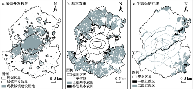
Fig. 1 The three control lines of urban planning area in Shenyang图1 沈阳市规划区三条控制线划定方案 |
Table 2 Ecological protection redline summary (km2)表2 生态保护红线统计 |
| 序号 | 类型 | 红线区 | 一类红线区 | 二类红线区 | 合计 |
|---|---|---|---|---|---|
| 1 | 法定保护地红线区 | 山地自然保护区红线区 | 16.28 | 78.57 | 94.85 |
| 2 | 森林公园红线区 | 10.74 | 10.74 | ||
| 3 | 风景名胜区红线区 | 16.84 | 50.96 | 67.8 | |
| 4 | 水源保护地红线区 | 12.36 | 12.36 | ||
| 5 | 生态功能及生态敏感脆弱红线区 | 林地红线区 | 70.66 | 70.66 | |
| 6 | 生态保护封育地红线区 | 15.74 | 15.74 | ||
| 7 | 河流及其防护带红线区 | 41.94 | 110.05 | 151.99 | |
| 8 | 湿地生态保护红线区 | 1.48 | 1.48 | ||
| 9 | 城市生态功能服务红线区 | 城市路网廊道绿化带红线区 | 49.35 | 49.35 | |
| 10 | 城市水系红线区 | 4.62 | 4.62 | ||
| 11 | 城市及郊野公园红线区 | 21.41 | 21.41 | ||
| 合计 | 75.06 | 425.94 | 501 | ||
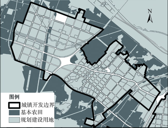
Fig. 2 Permanent basic farmland and urban development border cutting each other图2 基本农田与城镇开发边界互相切割 |
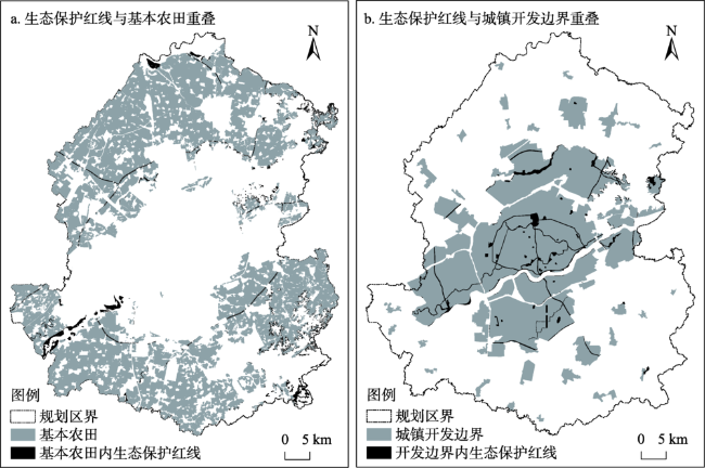
Fig. 3 Overlaps between ecological protection redline and permanent basic farmland & urban growth boundary图3 生态保护红线与永久基本农田、城镇开发边界交叉重叠 |
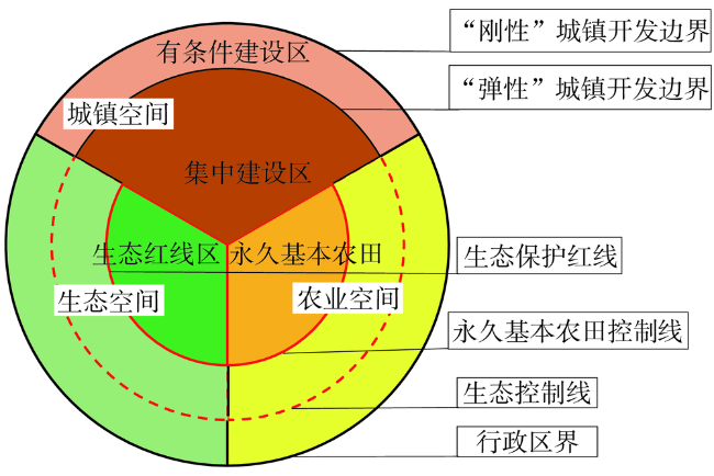
Fig. 4 Relationship between the three control lines and the three major spaces图4 三条控制线与三大空间关系示意 |
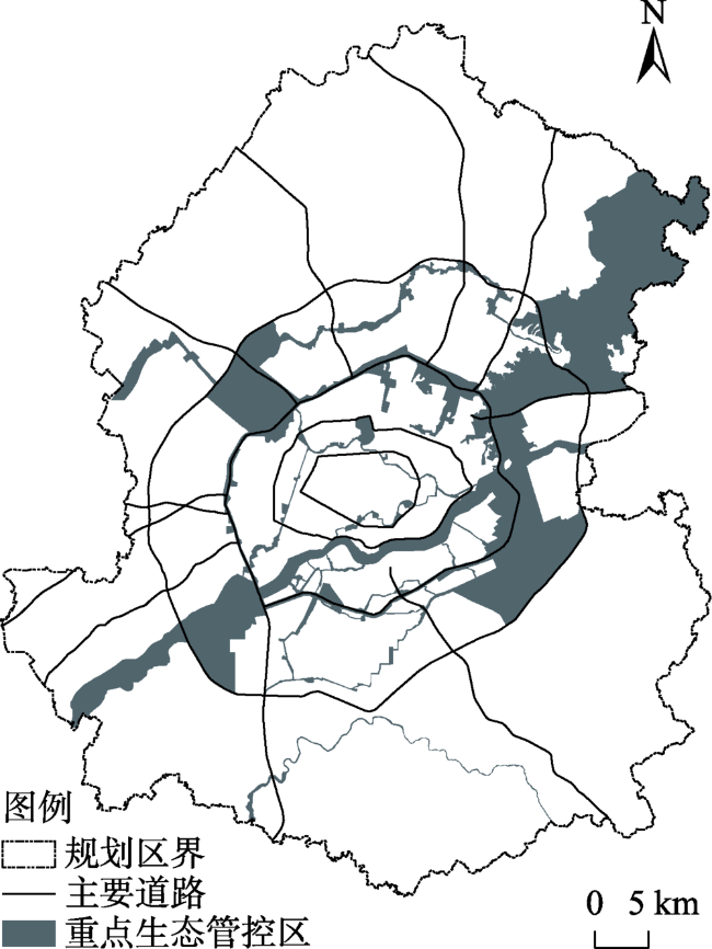
Fig. 5 Important ecological control areas distribution图5 重点生态管控区 |
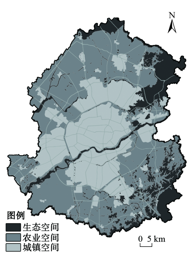
Fig. 6 Distribution of ecology space, agriculture space and urban space图6 生态、农业、城镇空间划定方案 |
| [1] |
[
|
| [2] |
[
|
| [3] |
[
|
| [4] |
[
|
| [5] |
[
|
| [6] |
[
|
| [7] |
[
|
| [8] |
[
|
| [9] |
[
|
| [10] |
[
|
| [11] |
[
|
| [12] |
[
|
| [13] |
[
|
| [14] |
[
|
| [15] |
[
|
| [16] |
[
|
| [17] |
[
|
| [18] |
[
|
| [19] |
[
|
/
| 〈 |
|
〉 |