
西藏自治区生态空间的分类与范围及人类活动影响
作者简介:魏子谦(1996- ),女,天津人,硕士,研究方向为自然资源信息科学。E-mail: weizq.18s@igsnrr.ac.cn
收稿日期: 2019-05-10
要求修回日期: 2019-08-19
网络出版日期: 2019-10-28
基金资助
第二次青藏高原综合科学考察研究(2019QZKK060300)
国家自然科学基金项目(41571496,41971263)
国家重点研发计划项目(2016YFC0503403)
西藏重大科技专项(Z2016C01G01/04)
Classification, scope and the impact of human activities of ecological space in Tibet Autonomous Region
Received date: 2019-05-10
Request revised date: 2019-08-19
Online published: 2019-10-28
Copyright
生态空间的划定是落实主体功能区制度,确定三种空间、三条红线的重要环节。目前生态空间概念界定尚未有共识、分类体系仍不统一。以西藏自治区为例,探索了生态脆弱区省级生态空间分类体系构建、空间范围识别及人类活动强度模拟的方法。结果表明:(1)按照生态系统类型西藏生态空间可分为林地、草地、湿地、未利用地等4个一级类,13个二级类和29个三级类。按照管制强度可分为I级严格管制区、II级限制开发区和III级动态管制区。(2)识别得到西藏生态空间面积约为105.45万km2,占西藏总面积的87.7%,与其国家重要生态安全屏障的功能定位一致。(3)模拟了西藏人类活动强度,生态空间内受人类胁迫水平整体较弱,约92%的区域人类活动强度指数低于0.0447。本研究可为高寒生态脆弱区省级生态空间划定及管理提供科技支撑。
魏子谦 , 徐增让 , 毛世平 . 西藏自治区生态空间的分类与范围及人类活动影响[J]. 自然资源学报, 2019 , 34(10) : 2163 -2174 . DOI: 10.31497/zrzyxb.20191012
The delimitation of ecological space is an important basis for the scientific management of territorial space and the maintenance of regional ecological security. Since the beginning of the 21st century, China has undergone an unprecedented rapid urbanization process, and the territorial spatial pattern has changed dramatically. However, during this period, a series of disorderly processes of territorial spatial development have resulted in the squeezing of ecological space and many severe regional ecological problems, such as land desertification, biodiversity reduction, ecosystem degradation, which restricts the realization of the goal of sustainable development. The definition of ecological space is mainly put forward by domestic scholars in recent years, and the corresponding concepts in other countries are ecoregion, ecological land space, and green space etc., and the classification system of ecological space is also not unified. Taking the Tibet Autonomous Region (TAR) as an example, we explored the classification system, spatial distribution, attribution of the patches, and human activities intensity of ecological space on provincial scale in the study. The results are as follows. (1) The classification system of ecological space can be composed by 3 hierarchal systems. According to various ecosystems and dominant functions, there are 4 land categories in the primary-class system, 13 sub-categories of land in the second-class system and 29 sub-categories of land in the third-class system. And according to the ecological governance intensity from the strictest regulation to the relatively relaxed regulation, ecological space can be divided into I-level, II-level and III-level areas. (2) Guided by the current spatial planning and governance system, the link between the classification system of ecological space and the existing land classification system such as the land cover and land use classification, ecosystem type was built; the spatial distribution of ecological space, and the attribution of the patches within the space was identified. Besides, the key ecosystem services functional area and the main ecological frangible area were also identified and included into the ecological space. The existing land classification system, the ecosystem services functional area and frangible ecosystem, and the various space can be integrated in GIS environment. The total ecological space of TAR is about 1054500 km2, accounting for 87.7% of the total area. (3) Finally, human activities within the ecological space in Tibet were simulated in order to control the human activities intensity of ecological space and to maintain the ecological security.
Table 1 Source of the main data applied in the study表1 主要数据及来源 |
| 数据名称 | 数据来源 |
|---|---|
| 土地利用现状分类(GB/T 21010-2017)[25] | 2017年由国土资源部组织修订的国家标准《土地利用现状分类》(GB/T 21010-2017) |
| 地理国情普查数据[26] | 《中国地理国情蓝皮书(2017版)》北京测绘出版社 |
| 1985-2005年1∶250000土地利用/覆被数据 | 1980年、2005年1∶250000土地覆被数据由地球系统科学数据共享平台(www.geodata.cn)提供 |
| 中国植被图集[27] | 《1∶1000000中国植被图集》北京科学出版社 |
| 中国生态系统服务空间数据集[29] | 2010年中国生态系统服务空间数据集, Science Data Bank, DOI: 10.11922/sciencedb.458. |
| 西藏生态脆弱性分布数据[30] | 西藏自治区人民政府. 藏政发[2014]108号《西藏自治区主体功能区规划》 |
| 西藏政区 | 国家基础地理信息测绘数据,网址http://www.ngcc.cn/ |
| 西藏道路 | 公路数据来自Open street map,https://www.openstreetmap.org/ |
| 人口、GDP、载蓄量数据 | 2017年西藏统计年鉴 |
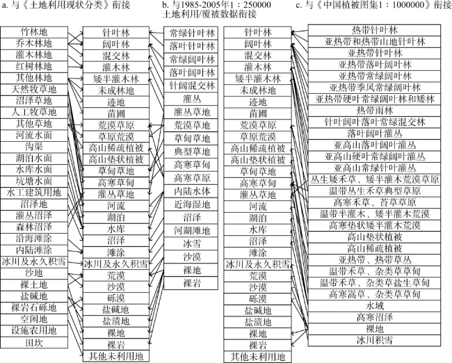
Fig. 1 Relationship of ecological space with the existing land classification systems图1 生态空间与不同分类体系的映射关系 |
Table 2 Classification index system of ecological space of Tibet表2 西藏自治区生态空间分类指标体系 |
| 一级类 | 二级类 | 三级类 | 描述 | 是否具有 普适性 |
|---|---|---|---|---|
| 林地(不包括用材林、经济林、薪炭林) | 乔木林 | 针叶林 | 自然或半自然针叶乔木植被,高度>2 m,郁闭度>30% | 是 |
| 阔叶林 | 自然或半自然阔叶乔木植被,高度>2 m,郁闭度>30% | 是 | ||
| 混交林 | 针阔混交天然林和人工林,高度>2 m,郁闭度>30% | 是 | ||
| 灌木林 | 灌木林 | 高度约2 m,郁闭度>40%的多年生灌木型木本植物 | 是 | |
| 矮半灌木林 | 高度<1 m,无明显主干的木本植物,地上部为1年生,地下部为多年生 | 是 | ||
| 其他林地 | 未成林地 | 造林时间不超过三年的人工新造林地 | 是 | |
| 迹地 | 采伐之后还未重新种树的土地 | 是 | ||
| 苗圃 | 培育苗木的园地 | 是 | ||
| 草地(不包括非生态脆弱区的高寒草甸、草甸草地及灌丛草地) | 荒漠草原 | 荒漠草原 | 覆被度5%~20%,以丛生小禾草为主的旱生草原 | 否 |
| 草原荒漠 | 在荒漠的自然基础上经植树种草等人工改造的草原 | 否 | ||
| 高山植被 | 高山稀疏植被 | 覆被度4%~20%,分布在海拔>3000 m的草本植被 | 否 | |
| 高山垫状植被 | 生长在高寒地区呈半球状或莲座状凸起的垫状植物丛 | 否 | ||
| 脆弱区牧草地 | 草甸草地 | 位于生态脆弱区内覆盖度>30%,以草本植物为主的各类草地 | 否 | |
| 高寒草甸 | 位于生态脆弱区内覆盖度在>20%,以高海拔寒生植物为主的草地 | 否 | ||
| 灌丛草地 | 位于生态脆弱区内覆盖度<40%灌丛高度<2 m的草地 | 否 | ||
| 湿地(不包括养殖水面) | 水域 | 河流 | 指河流常水位岸线之间的带状或线状水体 | 是 |
| 湖泊 | 指天然积水区常水位岸线所围成的面状水体 | 是 | ||
| 水库 | 指人工积水区常水位岸线所围成的面状水体 | 是 | ||
| 沼泽 | 沼泽 | 地势平坦低洼,长期潮湿多积水且表层生长湿生草本植被的土地 | 是 | |
| 滩涂 | 河流沿岸或湖泊周边的滩地,包括边滩、心滩等 | 是 | ||
| 冰雪地 | 冰川及永久积雪 | 指表层常年被冰雪覆盖的土地 | 是 | |
| 未利用地 | 荒漠 | 荒漠 | 植被覆盖度在5%以下,表面松散的壤质荒漠 | 是 |
| 沙漠 | 植被覆盖度在5%以下的沙地、流动沙丘 | 是 | ||
| 砾漠 | 植被覆盖度在5%以下以石砾为主的荒漠 | 是 | ||
| 盐碱地 | 盐碱地 | 指表层裸露物以盐碱为主或生长有天然耐盐植物的土地 | 是 | |
| 盐渍地 | 在深1 m的地表土层内,易溶盐含量大于0.3%的土地 | 是 | ||
| 裸地 | 裸地 | 地表为土质、植被覆盖度在5%以下的无植被地段 | 是 | |
| 裸岩 | 地表以岩石或石砾为主、植被覆盖度在5%以下的裸露石山、戈壁 | 是 | ||
| 其他未利用地 | 其他未利用地 | 其他未利用地 | 是 |
注:数据来源于文献 [15,18,25,27,31-34]。 |
Table 3 Zonal system of ecological space表3 生态空间分区 |
| 生态空间分区 | 包含范围 | 管制要求 |
|---|---|---|
| I级生态空间 | 生态保护红线区域 | 原则上按照禁止开发区要求进行管理,实施强制性的生态保护措施 |
| II级生态空间 | 重要生态系统功能区或生态脆弱区 | 原则上按照限制开发区的要求管理,允许符合区域产业和项目准入条件的项目进驻 |
| III级生态空间 | 其他生态空间 | 执行更宽松的管理要求,制定准入条件,允许更多种类的开发利用 |
Fig. 2 Ecological spatial scope connecting with existing land classification system in Tibet图2 与现有地类体系相衔接的生态空间范围 |
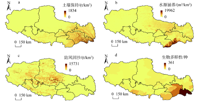
Fig. 3 Spatial distribution of main ecosystem services in Tibet Autonomous Region图3 西藏自治区主要生态系统服务分布 |
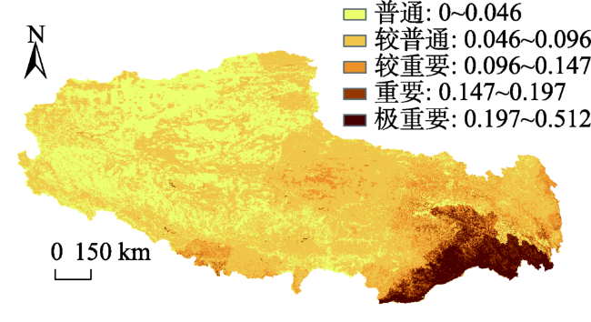
Fig. 4 Comprehensive index of ecosystem services in Tibet图4 西藏生态系统服务综合指数 |
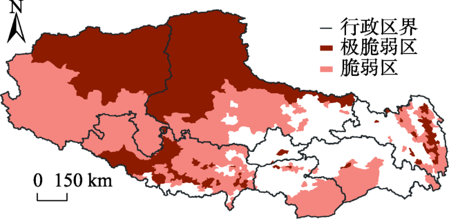
Fig. 5 Spatial distribution of ecological vulnerability in Tibet图5 西藏地区生态脆弱性分布 |
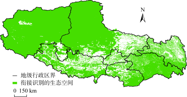
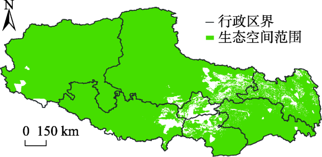
Fig. 6 Spatial distribution of ecological space in Tibet图6 西藏地区生态空间分布 |
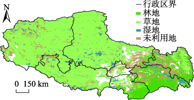
Fig. 7 The primary classification of ecological space in Tibet图7 西藏自治区生态空间一级分类 |
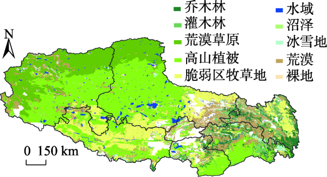
Fig. 8 The secondary classification of ecological space in Tibet图8 西藏自治区生态空间二级分类 |
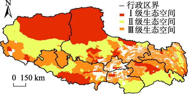
Fig. 9 The governance zone of ecological space in Tibet图9 生态空间管控分区 |
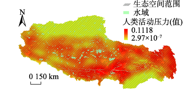
Fig. 10 Spatial distribution of human activity intensity in the ecological space in Tibet图10 西藏人类活动强度及在生态空间的分布 |
| [1] |
[
|
| [2] |
[
|
| [3] |
[
|
| [4] |
中共中央办公厅、国务院办公厅. 省级空间规划试点方案. 人民日报, 2017-01-09(02).
[The Central Committee of the Communist Party of China, the State Council. Provincial spatial planning pilot program. People's Daily, 2017-01-09(02).]
|
| [5] |
中共中央、国务院. 关于建立国土空间规划体系并监督实施的若干意见. 人民日报, 2019-05-24(02).
[The Central Committee of the Communist Party of China, the State Council. Some opinions on the establishment of a territorial spatial planning system and supervision of its implementation. People's Daily, 2019-05-24.]
|
| [6] |
[
|
| [7] |
|
| [8] |
|
| [9] |
|
| [10] |
|
| [11] |
|
| [12] |
|
| [13] |
|
| [14] |
|
| [15] |
|
| [16] |
|
| [17] |
[
|
| [18] |
[
|
| [19] |
[
|
| [20] |
[
|
| [21] |
|
| [22] |
|
| [23] |
[
|
| [24] |
[
|
| [25] |
中国土地勘测规划院, 国土资源部地籍管理司. 土地利用现状分类. 北京: 中国标准出版社, 2017: 1-17.
[Chinese Academy of Land Survey and Planning, Department of Cadastral Management, Ministry of Land and Resources. Classification of Land Use Status. Beijing: China Standard Press, 2017: 1-17.]
|
| [26] |
中国测绘科学研究院. 中国地理国情蓝皮书(2017版). 北京: 测绘出版社, 2018: 117-209.
[Chinese Academy of Surveying and Mapping Sciences. Blue Book on China's Geographical Situation (2017). Beijing: Surveying and Mapping Publishing House, 2018: 117-209.]
|
| [27] |
中国科学院中国植被编辑委员会. 中国植被图集: 1∶1000000. 北京: 科学出版社, 2001: 198-231.
[Vegetation Map Editorial Board of Chinese Academy of Sciences. Vegetation Map of China (1∶1000000). Beijing: Science Press, 2001: 198-231.]
|
| [28] |
[
|
| [29] |
[
|
| [30] |
[
|
| [31] |
[
|
| [32] |
[
|
| [33] |
[
|
| [34] |
[
|
| [35] |
|
| [36] |
[
|
| [37] |
[
|
/
| 〈 |
|
〉 |