
基于自然资源本底的国土空间规划现状一张图构建及应用——以青岛市为例
作者简介:韩青(1971- ),女,山东济南人,博士,研究员,研究方向为城市与区域规划。E-mail: 462949506@qq.com
收稿日期: 2019-05-23
要求修回日期: 2019-09-10
网络出版日期: 2019-10-28
Establishment and application of one map of current situation of territorial spatial planning according to the foundations of natural resources: Taking Qingdao city as an example
Received date: 2019-05-23
Request revised date: 2019-09-10
Online published: 2019-10-28
Copyright
国土空间规划体系构建工作已经全面展开,清晰详实的现状图和数据是摸清自然资源家底的重要基础,也是编制国土空间规划的重要支撑。而当前国土空间现状数据的用地分类标准、数据精度和应用目标等尚不统一。基于遥感影像、地理国情和互联网POI等多源数据进行国土空间现状一张图研究,综合现有用地分类标准和数据精度,构建青岛市国土空间规划现状一张图。在此基础上,探讨国土空间规划一张图应用方向,包括青岛市“三生空间”和资源环境研判分析,以及城镇建设适宜性、生态服务功能重要性和农业生产适宜性分析等内容。国土空间规划现状一张图的构建,对于明确资源利用上限与环境质量底线,规范国土空间规划数据,以及支撑国土空间规划编制和管理具有重要作用。
关键词: 国土空间规划; 现状一张图构建及应用; 自然资源本底; 青岛市
韩青 , 孙中原 , 孙成苗 , 李丹 , 刘一萍 . 基于自然资源本底的国土空间规划现状一张图构建及应用——以青岛市为例[J]. 自然资源学报, 2019 , 34(10) : 2150 -2162 . DOI: 10.31497/zrzyxb.20191011
The construction of the territorial spatial planning system has been fully carried out. The clear and detailed status map and data are an important basis for understanding the natural resources, and also an important support for the preparation of territorial spatial planning. However, the current land classification standards, data accuracy and application targets of the current territorial spatial data are not uniform. Based on remote sensing images, geographic conditions and Internet POI data, this paper studies one map of land and space status, synthesizes existing land classification standards and data accuracy, and constructs one map of territorial spatial planning status of Qingdao city. On this basis, the application direction of one map of territorial spatial planning is discussed, including the preliminary delimitation of "Production-Living-Ecological Space" in Qingdao city. The suitability of urban construction, the importance of ecological service function and the suitability of agricultural production were analyzed. The construction of one map of the status of territorial spatial planning plays an important role in defining the resource utilization cap and the environmental quality bottom line, standardizing the territorial spatial planning data, and supporting the preparation and management of territorial spatial planning.
Table 1 Data selection principle表1 数据选用原则 |
| 数据名称 | 地块外边界确定 | 地块内边界确定 | 用地属性确定 | 现势性 | 数据范围 | 数据来源 |
|---|---|---|---|---|---|---|
| 现状用地 | ★ | ★★★★ | ★ | 2017年 | 青岛市全域 | 青岛市自然资源和规划局 |
| 地形图 | ★★ | ★ | ★★★★ | 2010-2018年 | 城市建制镇范围 | 青岛市自然资源和规划局 |
| 城镇地籍 | ★★★ | ★★★★ | ★★ | 2017年 | 城市建制镇范围 | 青岛市自然资源和规划局 |
| 地理国情 | ★ | ★★★ | ★★★ | 2017年 | 青岛市全域 | 青岛市自然资源和规划局 |
| 纳税人数据 | ★★★ | ★★★ | 2018年 | 青岛市全域 | 互联网 | |
| 互联网POI | ★★★★ | 2018年 | 青岛市全域 | 互联网 | ||
| 影像 | ★★★★ | ★ | ★ | 2018年 | 青岛市全域 | 青岛市自然资源和规划局 |
注:表中★号的数量表示该项数据在相关信息确定中的权重。 |
Table 2 Non-construction land classification expansion表2 非建设用地分类扩展 |
| 大类 | 中类 | 小类 |
|---|---|---|
| E非建设用地 | E1水域 | E11河流水面 |
| E12水库水面 | ||
| E13坑塘水面 | ||
| E14沿海滩涂 | ||
| E15内陆滩涂 | ||
| E16沟渠 | ||
| E2耕地 | E21水浇地 | |
| E22旱地 | ||
| E3园地 | E31果园 | |
| E32茶园 | ||
| E33其他园地 | ||
| E4林地 | E41有林地 | |
| E42灌木林地 | ||
| E43其他林地 | ||
| E5草地 | E51天然牧草地 | |
| E52沼泽草地 | ||
| E53人工牧草地 | ||
| E54其他草地 | ||
| E6设施农用地 | ||
| E9其他非建设用地 | E91盐碱地 | |
| E92沙地 | ||
| E92裸地 | ||
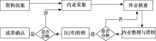
Fig. 1 Data construction process图1 数据构建过程 |
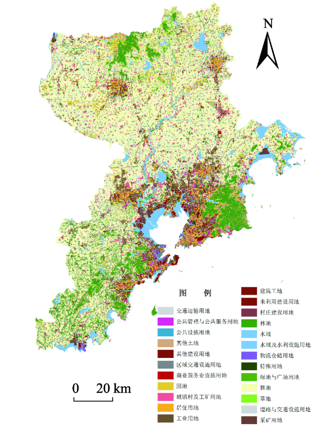
Fig. 2 Qingdao city's situation map of territorial space图2 青岛市国土空间现状一张图 |
Table 3 Classification system of "production-living-ecological" space表3 “三生空间”用地分类体系 |
| 区域类型 | 空间类型 | 代码及用地分类 |
|---|---|---|
| 城市与建制镇 | 生产 | H2区域交通设施用地、H42安保用地、H5采矿用地、H9其他建设用地、A1行政办公用地、A31高等院校用地、A32中等专业学校用地、A34特殊教育用地、A35科研事业单位用地、A42体育训练用地、A53特殊医疗用地、B2商务用地、B32康体用地、B9其他服务设施用地、M工业用地、W物流仓储用地(W1除外)、S道路与交通设施用地 |
| 生活 | H1城乡居民点建设用地、H3区域公共设施用地、H41军事用地、R居住用地、A2文化设施用地、A33中小学用地、A41体育场馆用地、A5医疗卫生用地(A53除外)、A6社会福利用地、A8外事用地、A9宗教用地、B1商业用地、B31娱乐用地、B4公共设施营业网点用地、W1一类物流仓储用地、U公共设施用地 | |
| 生态 | E—非建设用地、A7文物古迹用地、G绿地与广场用地 | |
| 乡村 | 生产 | 01耕地、02园地、06工矿仓储用地、10交通运输用地、1109水工建筑用地、1202设施农用地、1203田坎 |
| 生活 | 05商服用地、07住宅用地、08公共管理与公共服务用地、09特殊用地(0906除外)、1201空闲地 | |
| 生态 | 03林地、04草地、0906风景名胜设施用地、11水域及水利设施用地(1109除外)、12其他土地(1201、1202、1203除外) |
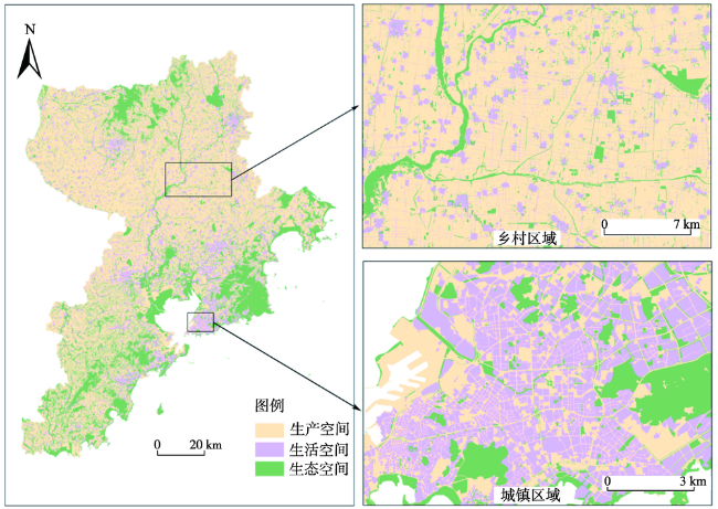
Fig. 3 Spatial distribution of "production-living-ecological" space图3 “三生空间”空间分布 |
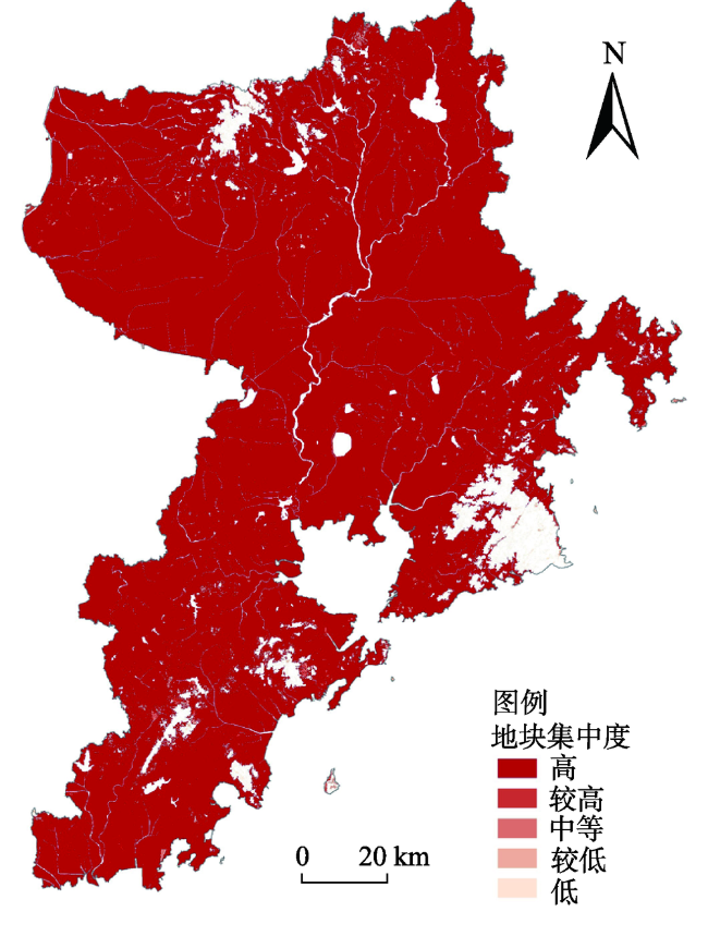
Fig. 4 Land concentration degree图4 地块集中度 |
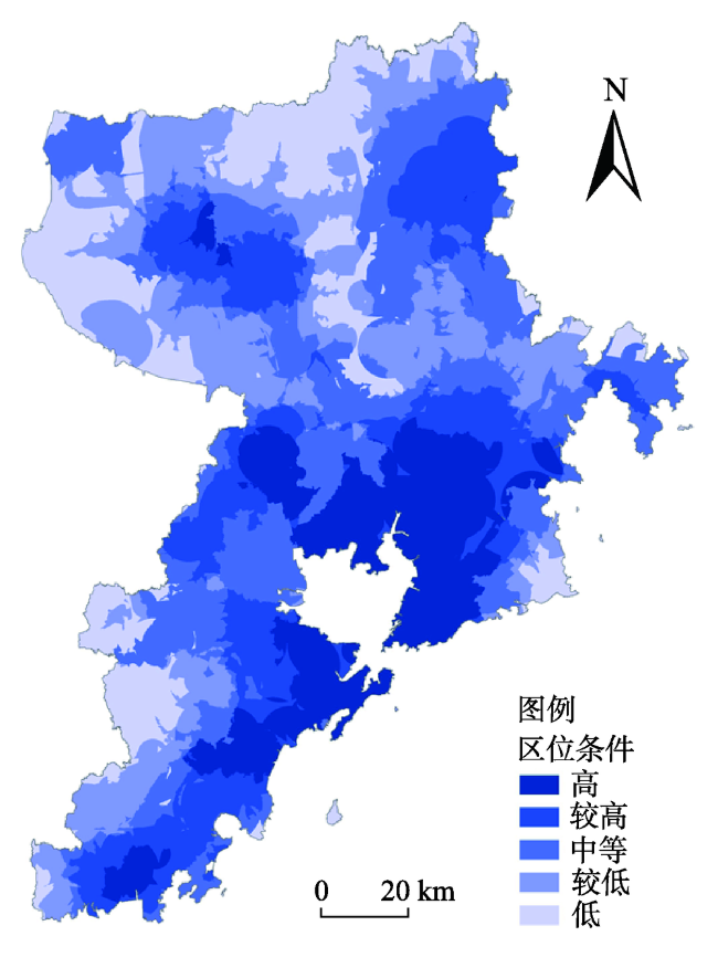
Fig. 5 Analysis of comprehensive advantage degree图5 综合优势度分析 |
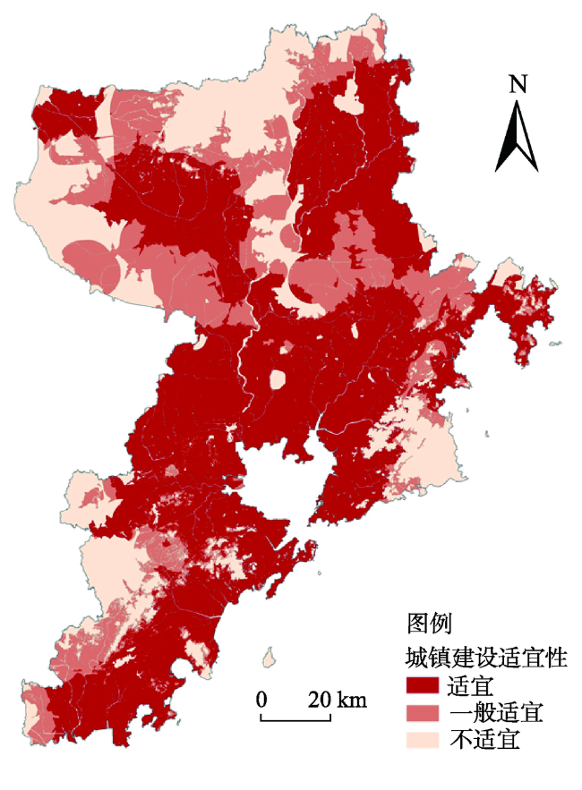
Fig. 6 Suitability analysis of urban construction图6 城镇建设适宜性分析 |
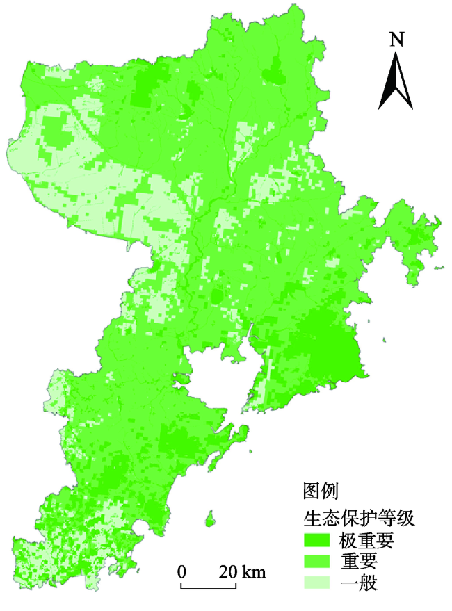
Fig. 7 Functional grade of eco-service图7 生态服务功能等级 |
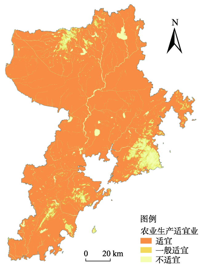
Fig. 8 Suitability analysis of agricultural production图8 农业生产适宜性分析 |
| [1] |
中华人民共和国中央人民政府. 中共中央国务院关于建立国土空间规划体系并监督实施的若干意见. 2019-05-23.
[The Central People's Government of the People's Republic of China. Several opinions of the central committee of the Central Committee of the Communist Party of China and The State Council on establishing a land spatial planning system and supervising implementation. 2019-05-23.]
|
| [2] |
新华网(两会受权发布). 关于国务院机构改革方案的说明. 2018-03-14.
[Xinhua Network.Explanation on the reform plan of the State Council's institutions. 2018-03-14.]
|
| [3] |
[
|
| [4] |
中华人民共和国自然资源部. 聚焦部开展国土空间规划“一张图”建设和现状评估工作. 2019-07-26.
[Ministry of Natural Resources of the People's Republic of China. Focus on the ministry of land spatial planning "one map" construction and current situation assessment. 2019-07-26.]
|
| [5] |
[
|
| [6] |
[
|
| [7] |
[
|
| [8] |
[
|
| [9] |
[
|
| [10] |
中国国家标准化管理委员会. GB/T21010-2017, 土地利用现状分类. 2017.
[China National Standardization Management Committee. GB/T 21010-2017, Classification of Land Use Status. 2017.]
|
| [11] |
中华人民共和国住房和城乡建设部. GB 50137-2011, 城市用地分类与规划建设用地标准. 2012.
[Ministry of Housing and Urban-Rural Construction of the People's Republic of China. GB 50137-2011, Urban Land Classification and Planning Standards for Construction Land. 2012.]
|
| [12] |
[
|
| [13] |
[
|
| [14] |
[
|
| [15] |
[
|
| [16] |
[
|
| [17] |
[
|
| [18] |
[
|
| [19] |
[
|
| [20] |
[
|
| [21] |
[
|
| [22] |
[
|
| [23] |
[
|
| [24] |
[
|
| [25] |
[
|
| [26] |
[
|
| [27] |
[
|
| [28] |
[
|
| [29] |
[
|
| [30] |
[
|
| [31] |
[
|
| [32] |
[
|
| [33] |
[
|
| [34] |
[
|
| [35] |
[
|
| [36] |
中华人民共和国环境保护部. 生态保护红线划定技术指南. 2015-05-08.
[Ministry of Environmental Protection of the People's Republic of China. Technical Guidelines for the Delimitation of Red Line for Ecological Protection. 2015-05-08.]
|
| [37] |
[
|
| [38] |
[
|
/
| 〈 |
|
〉 |