
国土空间规划大数据应用方法框架探讨
作者简介:秦萧(1987- ),男,江苏盐城人,博士,副研究员,研究方向为大数据与城乡规划方法。E-mail: x.qin@nju.edu.cn
收稿日期: 2019-05-05
要求修回日期: 2019-08-02
网络出版日期: 2019-10-28
基金资助
国家自然科学基金项目(51708276,41571146)
中国博士后科学研究基金项目(2017M611781)
地理空间大数据挖掘与应用湖南省重点实验室开放研究基金项目(201803)
Discussion on the application framework of big data in territorial spatial planning
Received date: 2019-05-05
Request revised date: 2019-08-02
Online published: 2019-10-28
Copyright
新时代国土空间规划的核心目标为“满足人民对美好生活的需求”和“自然资源保护”并重。作为国家部门调整后的新规划类型,国土空间规划编制的方法研究整体缺乏,学者主要聚焦于自然资源本身的禀赋情况,利用传统统计、空间及调查数据和统计分析、空间分析及归纳演绎等方法对国家及省域层面的国土空间承载力与适宜性进行静态评价,对生态红线、基本农田保护线、城镇开发边界进行刚性划定。然而,现有研究较少考虑人类活动对国土空间利用的动态影响,缺乏对新发展趋势之下的生态空间、农业空间及城镇空间的科学安排。本文引入能够直接反映人类活动时空变化的大数据,重点从国土空间适宜性评价、生态空间规划、农业空间规划及城镇空间规划四个环节探讨了大数据应用的方向与具体方法框架,强调“自然空间”+“社会经济活动”相互作用下的国土空间规划编制的科学化路径。
秦萧 , 甄峰 , 李亚奇 , 陈浩 . 国土空间规划大数据应用方法框架探讨[J]. 自然资源学报, 2019 , 34(10) : 2134 -2149 . DOI: 10.31497/zrzyxb.20191010
In the new era, the core goal of territorial spatial planning is to meet the people's needs for a better life and also to protect natural resources. As a new type of planning, the method of territorial spatial planning is generally lacking. Based on the endowment of natural resources, scholars use data based on statistics and surveys, as well as methods of statistical analysis, spatial analysis and deduction to evaluate the carrying capacity and suitability of land space at the national and provincial levels, and make a static delimitation of the ecological red line, prime farmland protection line and urban development boundary. However, the existing studies rarely consider the dynamic impact of human activities on the use of land space, and lack the scientific arrangement of ecological space, agricultural space and urban space under the new development trend. This paper introduces the big data which can directly reflect the temporal and spatial changes of human activities. It mainly discusses the direction and specific methodological framework of the application of big data from the four parts of territorial spatial suitability evaluation, ecological spatial planning, agricultural spatial planning and urban spatial planning. Meanwhile, it emphasizes the scientific path of territorial spatial planning compilation under the interaction of "natural space" and "social and economic activities".
Key words: territorial spatial planning; big data; methodology framework
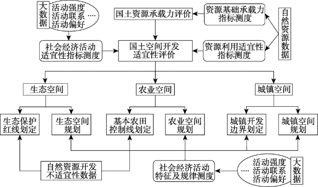
Fig. 1 The application framework of big data in territorial spatial planning图1 国土空间规划大数据应用框架 |
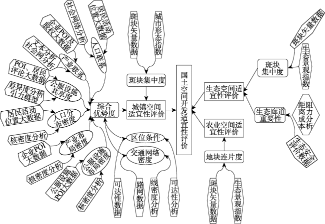
Fig. 2 The application framework of big data in suitability evaluation of territorial space图2 国土空间适宜性评价大数据应用框架 |
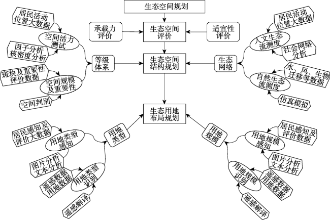
Fig. 3 The application framework of big data in ecological spatial planning图3 生态空间规划大数据应用框架 |
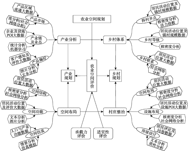
Fig. 4 The application framework of big data in agricultural spatial planning图4 农业空间规划大数据应用框架 |
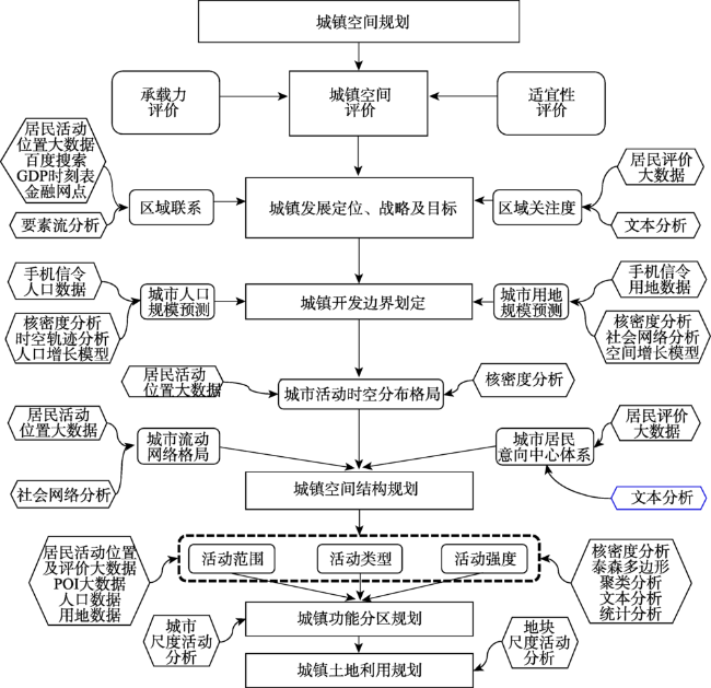
Fig. 5 The application framework of big data in urban spatial planning图5 城镇空间规划大数据应用框架 |
| [1] |
[
|
| [2] |
[
|
| [3] |
[
|
| [4] |
[
|
| [5] |
[
|
| [6] |
[
|
| [7] |
[
|
| [8] |
[
|
| [9] |
[
|
| [10] |
[
|
| [11] |
[
|
| [12] |
[
|
| [13] |
|
| [14] |
|
| [15] |
|
| [16] |
[
|
| [17] |
[
|
| [18] |
[
|
| [19] |
[
|
| [20] |
|
| [21] |
|
| [22] |
[
|
| [23] |
[
|
| [24] |
[
|
| [25] |
[
|
| [26] |
[
|
| [27] |
[
|
| [28] |
[
|
| [29] |
[
|
| [30] |
[
|
| [31] |
|
| [32] |
[
|
| [33] |
[
|
| [34] |
[
|
/
| 〈 |
|
〉 |