
多源数据融合的市县国土空间规划人口城镇化模式——以扬州市为例
作者简介:朱杰(1982- ),男,江苏扬州人,硕士,高级城市规划师,主要从事区域发展与国土空间规划研究。E-mail: zhujieclark@126.com
收稿日期: 2019-04-28
要求修回日期: 2019-07-25
网络出版日期: 2019-10-28
基金资助
国家自然科学基金项目(41571146)
The model of population urbanization in urban land spatial planning based on multi-source data fusion: A case study of Yangzhou city
Received date: 2019-04-28
Request revised date: 2019-07-25
Online published: 2019-10-28
Copyright
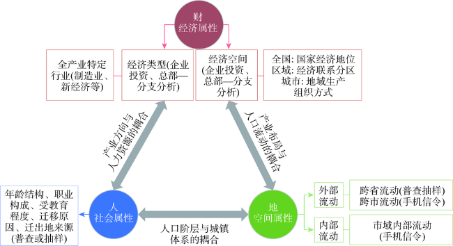
围绕“人、地、财”等新型城镇化三大核心问题,衍生出人口流动的社会、空间、经济属性,构建多源数据融合的人口城镇化概念模型。基于迁移流、位置识别和企业关联网络等方法,展开实证研究。结果表明:(1)区域层面:受落户门槛、家庭权益、社会保障等限制,人口流动比资本流动更为谨慎,也更遵从行政区经济和城镇等级体系。(2)市域层面:城镇化形式主要表现为城市和乡村的直接联系,重点镇辐射和吸纳作用不强。(3)新经济使后发地区弯道超车成为可能。研究发现此概念模型适用性较好,能够合理识别经济社会联系的主体格局,为城镇开发边界划定和国土空间格局优化起到一定的支撑作用,对市县国土空间规划的区域协调研究具有较强的参考价值。
朱杰 . 多源数据融合的市县国土空间规划人口城镇化模式——以扬州市为例[J]. 自然资源学报, 2019 , 34(10) : 2087 -2102 . DOI: 10.31497/zrzyxb.20191006
Nowadays, with the increasingly coordinated development of regions, the study of population urbanization also urgently needs to be carried out from a broad regional perspective. Focusing on the three core issues of new urbanization, mamely, people, land, and property, the social, spatial, and economic attributes on population mobility are derived. Based on a comparison of the advantages and disadvantages of commonly used data methods in urbanization analysis, this paper constructs a new conceptual model for population urbanization in different scales with multi-source data. Using the census and survey data, mobile phone data, and enterprise registration data, the conceptual model is applied to an empirical study of urban dense areas-Yangzhou city and shows strong applicability, based on migration flow analysis, location identification, and enterprise headquarters-branch network analysis methods. The results show that: (1) At the regional level, due to the factors such as the threshold of settlement, family rights, and social security, population mobility is more cautious than capital flows. And it is compliant with the administrative district economy and urban hierarchy system. (2) At the municipal level, because the central city has greater advantages than the villages and towns, in terms of public service facilities and income levels, the urbanization form is mainly manifested in the direct connection between urban and rural areas, while the radiating and absorbing effects of key towns for population and enterprises are not strong. (3) In the era of ecological civilization, places with beautiful scenery, profound history, and rich cultural heritage are the natural soil for new economy. And the new economy has become a powerful engine for new urbanization in the late-developing areas. Yangzhou has a pleasant ecological environment and profound cultural atmosphere, which is the natural advantage and foundation of developing new types of economy. It needs to develop industrial platform, innovative environment, and innovation system to jointly create a comprehensive advantage of new economic development. Empirical research shows that the conceptual model has good applicability. It can identify the main pattern of economic and social linkages scientifically, reveal the intensive communicating area in town cluster region, and play a supporting role in delimiting urban development boundaries and optimizing the spatial pattern of land. Therefore, this model has a strong reference value for the study of regional coordination of territorial spatial plan at city and county level.
Table 1 Comparison of advantages and disadvantages of traditional data and big data in population flow analysis表1 传统数据和大数据在人口流动分析方面的优劣势比较 |
| 属性 | 人口普查或抽样序列 | 手机信令 | |
|---|---|---|---|
| 时间跨度 | 长期趋势:普查10年一次,1%抽样调查5年一次 | 短期特点:一周、一日分析居多 | |
| 空间尺度 | 国家 | 全国人口总体发展特征,省区人口流动特征 | 数据量巨大,不适宜分析 |
| 区域 | 人口流动数据无法分解到地级市和以下层级 | 城市群/都市圈尺度可细分到县市 | |
| 城市 | 城市内部可细分到乡镇、街道,乃至村庄 | ||
| 数据结构 | 迁移人口属性数据丰富,涵盖年龄结构、职业构成、受教育程度、迁移原因等;但只有外来人口,缺乏外出人口 | 因数据保密性等因素,不含属性数据;但能够辨识外来、外出人口 | |
Fig. 1 The conceptual model of population urbanization based on three core issues图1 基于三大核心问题的人口城镇化模式概念模型 |
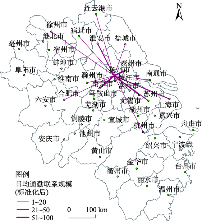
Fig. 2 The population communication pattern between Yangzhou and cities in Yangtze River Delta图2 扬州与长三角城市的人流联系格局 |
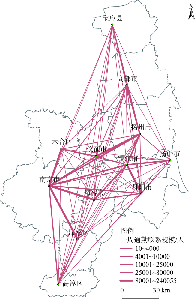
Fig. 3 The population communication pattern in Nanjing-Zhenjiang-Yangzhou metropolitan area图3 宁镇扬都市圈人流联系格局 |
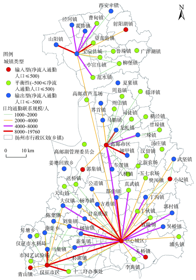
Fig. 4 The scale of one-workday commuting links between towns of Yangzhou图4 扬州市域乡镇街道的单日工作通勤联系规模 |
Table 2 The statistical table of employment sites of non-farm workers in the suburbs of Yangzhou表2 扬州城郊非农务工农民就业地点情况统计表 |
| 地点 | 人数/人 | 百分比/% |
|---|---|---|
| 本镇 | 579 | 57.1 |
| 扬州市区及其他乡镇 | 277 | 27.3 |
| 扬州市以外地区 | 158 | 15.6 |
| 总计 | 1014 | 100 |
注:资料来源于《扬州市区镇村布局规划》问卷调研,下同。 |
Table 3 The statistical table of residence of non-farm workers in the suburbs of Yangzhou表3 扬州城郊务工农民居住情况统计表 |
| 居住情况 | 人数/人 | 百分比/% |
|---|---|---|
| 住农村自家 | 629 | 61.67 |
| 住镇上自家房子 | 74 | 7.25 |
| 住城里自家房子 | 83 | 8.14 |
| 租房子或单位提供 | 206 | 20.2 |
| 拒绝回答 | 28 | 2.75 |
| 总计 | 1020 | 100 |
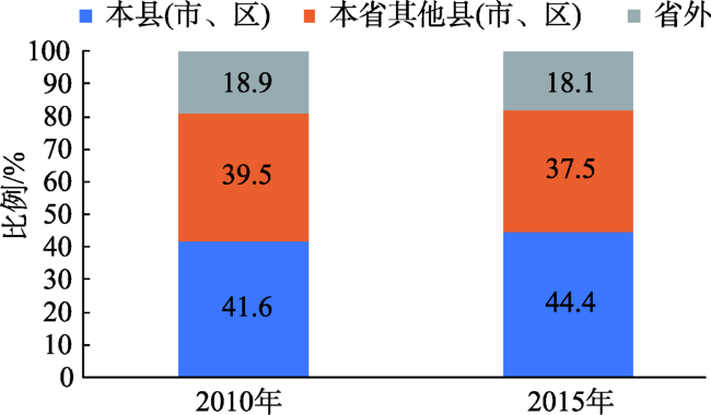
Fig. 5 The origin composition of household registration for migrant population in Yangzhou in 2010 and 2015图5 2010年和2015年扬州外来人口户籍来源地构成 |
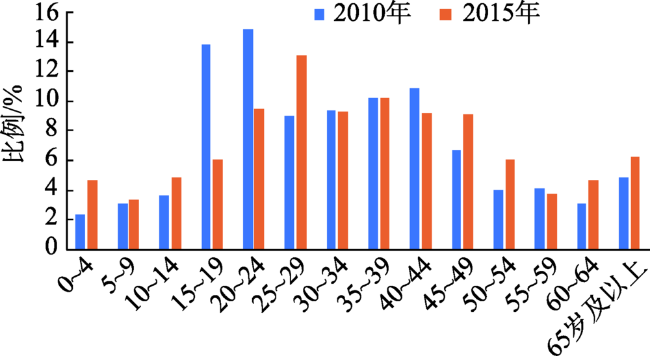
Fig. 6 The age composition of immigrant in Yangzhou in 2010 and 2015图6 2010年和2015年扬州外来人口年龄构成 |
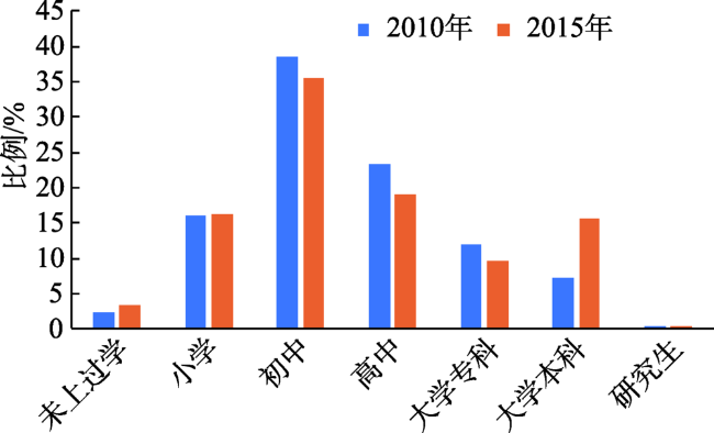
Fig. 7 The educational level of immigrants in Yangzhou in 2010 and 2015图7 2010年和2015年扬州外来人口受教育程度 |
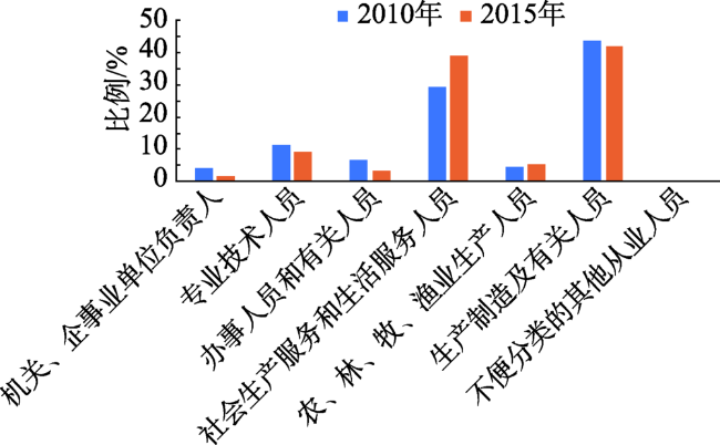
Fig. 8 The occupation classification of immigrant in Yangzhou in 2010 and 2015图8 2010年和2015年扬州外来人口职业大类构成 |
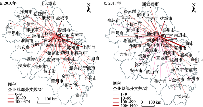
Fig. 9 Headquarters-branch enterprise linkage network between Yangzhou and prefecture-level cities in Yangtze River Delta图9 长三角地级以上城市与扬州的总部—分支企业关联网络 |
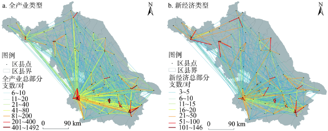
Fig. 10 Headquarters-branch linkage network of enterprises in county-level cities of Jiangsu province in 2017图10 2017年江苏县级城市企业总部—分支关联网络 |
Table 4 The headquarters-branch linkage of prefecture-level cities in Jiangsu under the classification of whole industry and new economy表4 江苏省设区市全产业和新经济分类下企业总部—分支关联度 |
| 城市名称 | 全产业门类 | 新经济门类 | 新经济分类下关联度提升情况/% | |||
|---|---|---|---|---|---|---|
| 关联度 | 比例/% | 关联度 | 比例/% | |||
| 南京 | 39551 | 20.42 | 6468 | 17.91 | -2.51 | |
| 苏州 | 28313 | 14.62 | 4594 | 12.72 | -1.89 | |
| 无锡 | 18762 | 9.69 | 4051 | 11.22 | 1.53 | |
| 南通 | 16304 | 8.42 | 2570 | 7.12 | -1.30 | |
| 盐城 | 13927 | 7.19 | 2360 | 6.54 | -0.65 | |
| 徐州 | 13685 | 7.07 | 2661 | 7.37 | 0.30 | |
| 常州 | 12329 | 6.36 | 2018 | 5.59 | -0.78 | |
| 扬州 | 11999 | 6.19 | 2068 | 5.73 | -0.47 | |
| 淮安 | 9104 | 4.70 | 2038 | 5.64 | 0.94 | |
| 泰州 | 8759 | 4.52 | 2068 | 5.73 | 1.21 | |
| 宿迁 | 7566 | 3.91 | 1780 | 4.93 | 1.02 | |
| 镇江 | 7406 | 3.82 | 1947 | 5.39 | 1.57 | |
| 连云港 | 5996 | 3.10 | 1486 | 4.12 | 1.02 | |
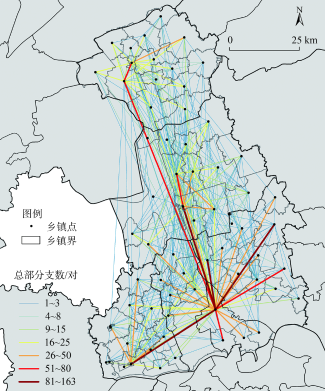
Fig. 11 Headquarters-branch linkage network of enterprises among towns in Yangzhou city in 2017图11 2017年扬州市域分乡镇企业总部—分支关联网络 |
Table 5 The coupling degree between enterprises interlocking network and migration from prefecture-level cities to Yangzhou in Yangtze River Delta表5 长三角各地市与扬州的企业关联网络和人口流动强度之间的耦合度 |
| 城市名称 | 标准化后企业 关联网络强度Y1 | 标准化后人口 通勤强度Y2 | 耦合度C |
|---|---|---|---|
| 南京市 | 1.00 | 1.00 | 1.000 |
| 合肥市 | 0.10 | 0.10 | 1.000 |
| 连云港市 | 0.11 | 0.10 | 0.999 |
| 盐城市 | 0.21 | 0.23 | 0.999 |
| 杭州市 | 0.13 | 0.10 | 0.993 |
| 徐州市 | 0.11 | 0.15 | 0.988 |
| 上海市 | 0.58 | 0.39 | 0.982 |
| 常州市 | 0.17 | 0.26 | 0.975 |
| 宿迁市 | 0.11 | 0.18 | 0.967 |
| 南通市 | 0.15 | 0.26 | 0.966 |
| 无锡市 | 0.18 | 0.34 | 0.951 |
| 苏州市 | 0.24 | 0.46 | 0.949 |
| 滁州市 | 0.10 | 0.23 | 0.918 |
| 淮安市 | 0.13 | 0.38 | 0.876 |
| 镇江市 | 0.15 | 0.51 | 0.838 |
| 泰州市 | 0.23 | 0.90 | 0.807 |
| 平均值 | 0.950 |
Table 6 The coupling degree between enterprises interlocking network and migration among towns in Yangzhou表6 扬州市域各乡镇企业关联网络和人口流动强度之间的耦合度 |
| 总部所在地 | 分支所在地 | 标准化后企业关联网络强度Y1 | 标准化后人口通勤强度Y2 | 耦合度C |
|---|---|---|---|---|
| 东关街道 | 丁沟镇 | 0.24 | 0.25 | 1.000 |
| 真州镇 | 新集镇 | 0.12 | 0.14 | 0.998 |
| 东关街道 | 公道镇 | 0.12 | 0.10 | 0.997 |
| 东关街道 | 真武镇 | 0.23 | 0.28 | 0.995 |
| 邵伯镇 | 东关街道 | 0.69 | 0.87 | 0.993 |
| 东关街道 | 邵伯镇 | 0.42 | 0.60 | 0.984 |
| 东关街道 | 樊川镇 | 0.29 | 0.19 | 0.980 |
| 东关街道 | 李典镇 | 0.14 | 0.22 | 0.977 |
| 马棚街道 | 高邮街道 | 0.16 | 0.25 | 0.970 |
| 杨寿镇 | 东关街道 | 0.13 | 0.23 | 0.964 |
| 安宜镇 | 泾河镇 | 0.20 | 0.38 | 0.953 |
| 东关街道 | 真州镇 | 1.00 | 0.53 | 0.952 |
| 安宜镇 | 氾水镇 | 0.20 | 0.39 | 0.949 |
| 安宜镇 | 射阳湖镇 | 0.38 | 0.19 | 0.947 |
| 东关街道 | 郭村镇 | 0.36 | 0.18 | 0.946 |
| 东关街道 | 安宜镇 | 0.60 | 0.30 | 0.942 |
| 东关街道 | 吴桥镇 | 0.12 | 0.24 | 0.940 |
| 东关街道 | 小纪镇 | 0.49 | 0.22 | 0.928 |
| 小纪镇 | 东关街道 | 0.10 | 0.24 | 0.911 |
| 安宜镇 | 山阳镇 | 0.24 | 0.58 | 0.911 |
| 安宜镇 | 望直港镇 | 0.26 | 0.62 | 0.910 |
| 东关街道 | 头桥镇 | 0.15 | 0.37 | 0.904 |
| 真州镇 | 马集镇 | 0.20 | 0.65 | 0.851 |
| 东关街道 | 丁伙镇 | 0.16 | 0.53 | 0.850 |
| 东关街道 | 甘泉街道 | 0.12 | 0.44 | 0.826 |
| 东关街道 | 宜陵镇 | 0.21 | 0.76 | 0.825 |
| 东关街道 | 高邮街道 | 0.98 | 0.26 | 0.818 |
| 高邮街道 | 卸甲镇 | 0.12 | 0.47 | 0.813 |
| 高邮街道 | 龙虬镇 | 0.11 | 0.47 | 0.778 |
| 真州镇 | 东关街道 | 0.17 | 0.87 | 0.742 |
| 杨庙镇 | 东关街道 | 0.19 | 1.00 | 0.739 |
| 平均值 | 0.913 | |||
| [1] |
[
|
| [2] |
[
|
| [3] |
[
|
| [4] |
[
|
| [5] |
[
|
| [6] |
[
|
| [7] |
|
| [8] |
[
|
| [9] |
[
|
| [10] |
[
|
| [11] |
[
|
| [12] |
[
|
| [13] |
[
|
| [14] |
[
|
| [15] |
[
|
| [16] |
自然资源部. 关于做好市县国土空间总体规划编制工作的指导意见(征求意见稿). 2019.
[Ministry of Natural Resources. Guiding Opinions on Making Overall Planning of Urban and County Territorial Space (Draft for Opinions). 2019.]
|
| [17] |
浙江省自然资源厅. 浙江省市县国土空间总体规划编制要点(征求意见稿). 2019.
[Ministry of Natural Resources in Zhejiang Province. Major Points for Making Overall Land and Space Planning of Cities and Counties in Zhejiang Province (Draft for Consultation). 2019.]
|
| [18] |
[
|
| [19] |
[
|
| [20] |
[
|
| [21] |
[
|
| [22] |
[
|
| [23] |
[
|
| [24] |
[
|
| [25] |
[
|
| [26] |
[
|
| [27] |
[
|
| [28] |
[
|
| [29] |
[
|
/
| 〈 |
|
〉 |