
基于空间聚类的中国东北气候分区及其气象干旱时间变化特征
作者简介:李明(1982- ),男,河南商丘人,副教授,主要从事区域气候变化方面的研究。E-mail: lim489@163.com
收稿日期: 2018-11-13
要求修回日期: 2019-05-07
网络出版日期: 2019-08-28
基金资助
国家自然科学基金项目(41501160,31571604)
山西省高校科技创新项目(20161113)
Climate regionalization and temporal evolution of meteorological drought in Northeast China based on spatial clustering
Received date: 2018-11-13
Request revised date: 2019-05-07
Online published: 2019-08-28
Copyright
近50年来,中国东北地区干旱化趋势明显,越来越频繁的干旱事件对该区域人民的生产和生活造成了严重的影响。基于1961-2016年中国地面降水和气温月值0.5°×0.5°格点数据,利用空间系统聚类方法对中国东北进行气候分区,通过标准化降水指数探讨了中国东北各亚区气象干旱的时间演变规律,并结合小波功率谱和小波全谱分析了各亚区干旱的周期变化特征。结果表明:(1)空间上,可将东北地区分为8个气候亚区,即西辽河平原半干旱农牧区、吉辽东部山地湿润农林区、呼伦贝尔高原半干旱牧业区、东北中部半湿润—半干旱农牧区、黑吉东部山地湿润农林区、大兴安岭北部湿润林业区、呼伦贝尔—黑河湿润—半湿润农林区、三江平原湿润农业区;(2)不同亚区的干旱事件时间演变特征存在明显差异,但大致都经历了3个干旱时期:1960s后期、1970s中后期至1980s前期、1990s后期至2000s;2000-2010年间东北地区干旱发生频率和影响范围最大,尤其是中、西部;(3)不同亚区干旱变化主要存在11年和3~8年的显著周期,第一主周期差异明显。研究结果对于弄清楚中国东北各亚区特有的气候变化驱动因素、制定气候均质区域干旱监测计划和水资源的管理具有重要的现实意义。
李明 , 王贵文 , 柴旭荣 , 胡炜霞 , 张莲芝 . 基于空间聚类的中国东北气候分区及其气象干旱时间变化特征[J]. 自然资源学报, 2019 , 34(8) : 1682 -1693 . DOI: 10.31497/zrzyxb.20190809
In the past 50 years, an increasing number of drought events have greatly affected the production and life of the people in Northeast China (NEC). The climatic conditions and sensitivities vary greatly in NEC due to complex terrain, large geographical range across latitudes and longitudes and different weather system effects. So, NEC is used to explore traditional geographical boundaries for meteorological drought research. In the paper, climate regionalization is performed by spatial hierarchical cluster approach based on the gridded dataset of monthly precipitation and temperature with a spatial resolution of 0.5°×0.5° in China from 1961 to 2016. Then, standardized precipitation index is employed to explore the temporal evolution of drought events, and wavelet method is used to detect drought periodicity in each sub-climatic region of NEC. The results show that: (1) Spatially, NEC can be divided into eight sub-climatic regions, namely, semi-arid agro-pastoral areas in the West Liaohe Plain, humid agro-forestry areas in the eastern mountainous areas of Jilin and Liaoning provinces, semi-arid pastoral areas in Hulun Buir Plateau, semi-humid and semi-arid agro-pastoral areas in central Northeast China, humid agro-forestry areas in the eastern mountainous areas of Heilongjiang and Jilin provinces, humid forestry areas in the north of Da Hinggan, humid and semi-humid agro-forestry areas in Hulun Buir Plateau and Heihe, and humid agricultural areas in Sanjiang Plain. (2) There are obvious differences for the temporal evolution of drought events in different sub-climatic regions, but three obvious drought periods, namely, late 1960s, late 1970s to early 1980s, and late 1990s to 2000s, can be found in each sub-region. The frequency and impact of droughts in NEC were the largest between 2000 and 2010, especially in the central and western parts of the study region. (3) There are significant drought periods of 11 years and 3-8 years in the eight sub-climatic regions of NEC, and the first main cycles of drought variation are not completely consistent. It is a very important step to divide a region into homogeneous sub-regions based on one or more climatic variables in climate studies. Therefore, the results of this paper have practical significance for identifying the drivers of climate variability specific to each sub-climatic region, establishing drought monitoring programs for climate homogeneous regions and managing water resources.
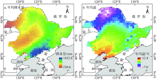
Fig. 1 Spatial pattern of annual precipitation and annual mean temperature in Northeast China from 1961 to 2016图1 1961-2016年年均降水量和年均温空间格局 |
Table 1 Drought categories according to SPI value表1 依据SPI的干旱等级划分 |
| 干旱等级 | 无旱 | 轻旱 | 中旱 | 重旱 | 特旱 |
|---|---|---|---|---|---|
| SPI值 | (-0.5, +∞) | (-1.0, -0.5] | (-1.5, -1.0] | (-2.0, -1.5] | (-∞, -2.0] |
Fig. 2 Climate regionalization in Northeast China图2 中国东北气候分区 |
Table 2 Inter-group/intra-group correlation coefficients for climate sub-regions in Northeast China表2 NEC各气候亚区组间/组内相关系数 |
| 亚区 | Ⅰ区 | Ⅱ区 | Ⅲ区 | Ⅳ区 | Ⅴ区 | Ⅵ区 | Ⅶ区 | Ⅷ区 |
|---|---|---|---|---|---|---|---|---|
| Ⅰ区 | 0.80 | |||||||
| Ⅱ区 | 0.58 | 0.87 | ||||||
| Ⅲ区 | 0.29 | 0.05 | 0.87 | |||||
| Ⅳ区 | 0.65 | 0.39 | 0.57 | 0.81 | ||||
| Ⅴ区 | 0.25 | 0.45 | -0.03 | 0.31 | 0.82 | |||
| Ⅵ区 | 0.01 | 0.01 | 0.55 | 0.21 | -0.14 | 0.83 | ||
| Ⅶ区 | 0.30 | 0.07 | 0.66 | 0.70 | 0.12 | 0.65 | 0.79 | |
| Ⅷ区 | 0.22 | 0.23 | 0.26 | 0.53 | 0.51 | 0.13 | 0.52 | 0.83 |
注:对角线数字为各分区的组内相关系数,其余数字为各分区的组间相关系数。 |
Table 3 Basic statistics of droughts for climate sub-regions in Northeast China表3 NEC气候亚区干旱指标统计 |
| 干旱指标/亚区 | Ⅰ区 | Ⅱ区 | Ⅲ区 | Ⅳ区 | Ⅴ区 | Ⅵ区 | Ⅶ区 | Ⅷ区 |
|---|---|---|---|---|---|---|---|---|
| 轻旱/月 | 86 | 102 | 104 | 113 | 92 | 73 | 114 | 75 |
| 中旱/月 | 85 | 65 | 50 | 65 | 71 | 62 | 50 | 69 |
| 重旱/月 | 19 | 30 | 39 | 37 | 36 | 30 | 29 | 42 |
| 特旱/月 | 18 | 4 | 4 | 8 | 11 | 14 | 13 | 5 |
| 总干旱历时/月 | 208 | 201 | 197 | 223 | 210 | 179 | 206 | 191 |
| 平均干旱历时/月 | 13.87 | 10.05 | 9.85 | 11.15 | 7.50 | 10.53 | 9.81 | 11.94 |
| 总干旱烈度 | 239.95 | 218.02 | 214.96 | 240.91 | 237.77 | 215.44 | 227.27 | 222.23 |
| 平均干旱烈度 | 15.99 | 10.90 | 10.75 | 12.05 | 8.49 | 12.67 | 10.82 | 13.89 |
| 干旱频次 | 15 | 20 | 20 | 20 | 28 | 17 | 21 | 16 |
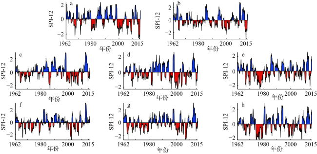
Fig. 3 Temporal evolution of regional average SPI-12 for the sub-climatic regions in Northeast China图3 NEC气候亚区SPI-12时间序列 |
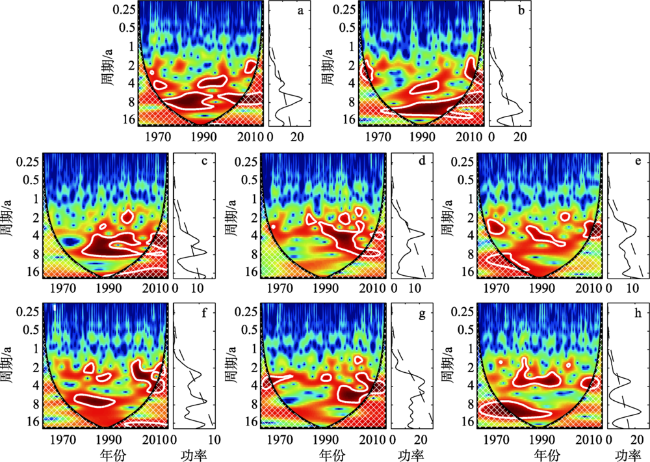
Fig. 4 The wavelet power spectrum using Morlet mother wavelet and the global wavelet spectrum about the SPI-12 time series of the eight sub-climatic regions图4 各气候亚区SPI-12时间序列的Morlet小波功率谱及其小波全谱图 |
Fig. 5 Climate regionalization with different clustering schemes in Northeast China图5 不同聚类数方案的东北气候分区结果 |
| [1] |
[
|
| [2] |
[
|
| [3] |
[
|
| [4] |
[
|
| [5] |
[
|
| [6] |
[
|
| [7] |
[
|
| [8] |
[
|
| [9] |
[
|
| [10] |
[
|
| [11] |
[
|
| [12] |
[
|
| [13] |
[
|
| [14] |
|
| [15] |
|
| [16] |
[
|
| [17] |
|
| [18] |
|
| [19] |
|
| [20] |
|
| [21] |
|
| [22] |
[
|
| [23] |
[
|
| [24] |
[
|
| [25] |
[
|
| [26] |
[
|
| [27] |
[
|
| [28] |
[
|
| [29] |
[
|
| [30] |
[
|
| [31] |
[
|
| [32] |
[
|
| [33] |
|
| [34] |
|
| [35] |
|
/
| 〈 |
|
〉 |

