
土地利用转型背景下的乡村景观格局演变响应——基于草堂溪流域的样带分析
李明珍(1993- ),女,陕西安康人,硕士,主要从事水土保持与土地利用研究。E-mail: li-mingzhen@foxmail.com
收稿日期: 2019-04-25
要求修回日期: 2019-07-31
网络出版日期: 2020-11-27
基金资助
重庆市基础研究与前沿探索项目(cstc2018jcyjA1934)
重庆市教育委员会人文社会科学研究项目(19JD026)
重庆师范大学研究生科研创新项目(CYS19293)
Evolution of rural landscape pattern under the background of land use transformation: Based on the transect analysis of Caotangxi watershed
Received date: 2019-04-25
Request revised date: 2019-07-31
Online published: 2020-11-27
Copyright
研究山区土地利用转型背景下乡村景观格局演变与转型,对山区现代化农业可持续发展和景观格局优化具有一定的指导意义。以三峡库区草堂溪流域为研究对象,利用ArcGIS 10.2和Fragstats 4.2软件,采用样带梯度分析结合景观格局分析方法,基于地形和社会经济因素,分别在河谷地区和山地丘陵地区设置5条样带,对研究区2000—2018年不同方向样带上景观格局梯度演变和驱动机制进行分析比较。结果表明:(1)景观类型整体变化幅度大致可分为较稳定型、逐年递减型和波动递增型,且景观转型的重点主要体现在耕地收缩、果园扩张和林地恢复性增长。(2)2000—2018年,研究区河谷地区的景观类型逐渐多样化,土地利用集聚,呈现空间集约化;而山地丘陵地区景观类型逐渐单一化,林地恢复。整体上由生产型景观格局转型成生态经济型、生态调节型为主的景观格局。(3)社会经济发展和政府政策导向等因素导致研究区内土地利用发生转型,在土地利用转型背景下的乡村景观格局也发生了相应的转变。研究结果可为类似山区土地资源的合理利用、生态治理和乡村振兴提供借鉴价值。
李明珍 , 李阳兵 , 冉彩虹 . 土地利用转型背景下的乡村景观格局演变响应——基于草堂溪流域的样带分析[J]. 自然资源学报, 2020 , 35(9) : 2283 -2298 . DOI: 10.31497/zrzyxb.20200919
Under the background of land use transformation in mountainous areas, the study on the evolution and transformation of rural landscape pattern has certain guiding significance for the sustainable development of modern agriculture and the optimization of landscape pattern in the same areas. This paper takes the Caotangxi watershed in the Three Gorges Reservoir area as the research object, using transect gradient analysis combined with landscape pattern analysis method, with the aid of ArcGIS 10.2 and Fragstats 4.2 software. Based on the topography and economic factors, five strips are set in the valley area and the mountainous/hilly areas to analyze and compare the gradient evolution and driving mechanism of the landscape pattern in different directions of the study area from 2000 to 2018. Results showed that: (1) The overall change of landscape types can be identified into relatively stable, decreasing year by year, and increasing fluctuations. The emphasis of landscape transformation is mainly reflected in the contraction of farmland, expansion of orchards, and restorative growth of forest land. (2) From 2000 to 2018, the landscape types in the valley of the study area were gradually diversified. Land use agglomeration showed a pattern of spatial intensification, while the landscape types in the mountainous and hilly areas gradually became simplistic and the forest land was restored. On the whole, the landscape pattern of production was transformed into a landscape pattern dominated by ecological economy and ecological regulation. (3) Social and economic development and agricultural policies have led to the land use transformation in the study area. Meanwhile, the rural landscape pattern has undergone a corresponding transformation in the context of land use transformation. The research results provide reference value for the rational use of mountainous land resources, ecological management and rural revitalization.
Fig. 1 Location and topography of the study area图1 研究区位置及地形 |
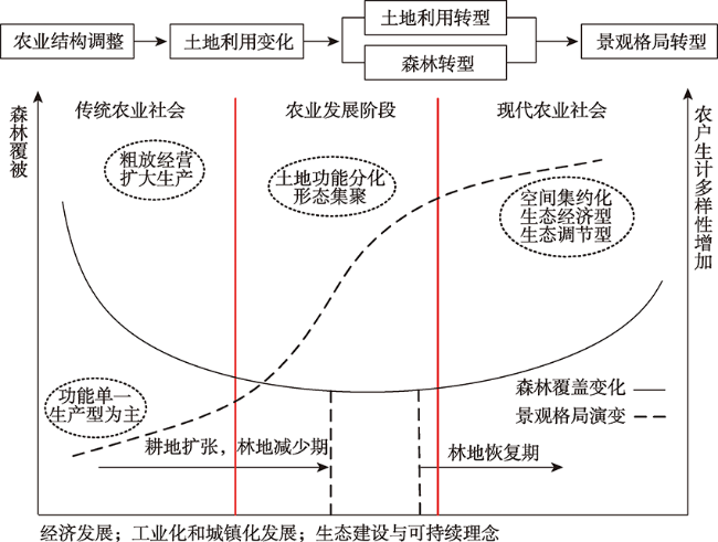
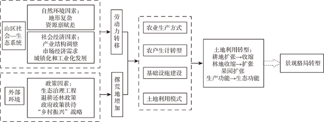
Fig. 2 Mechanism of landscape pattern transformation图2 景观格局转型发生机理 |
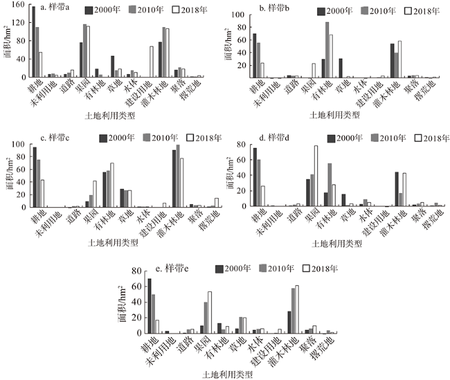
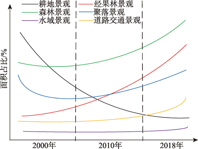
Fig. 3 Area of land use type in each transect图3 各样带上土地利用类型的面积 |
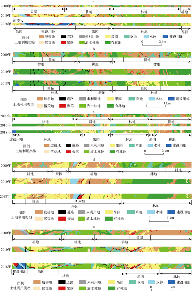
Fig. 4 Landscape maps of land use on extension axes of different transects图4 不同样带上的土地利用景观图 |
Fig. 5 Topographic profiles of different transects图5 各样带的地形剖面图 |
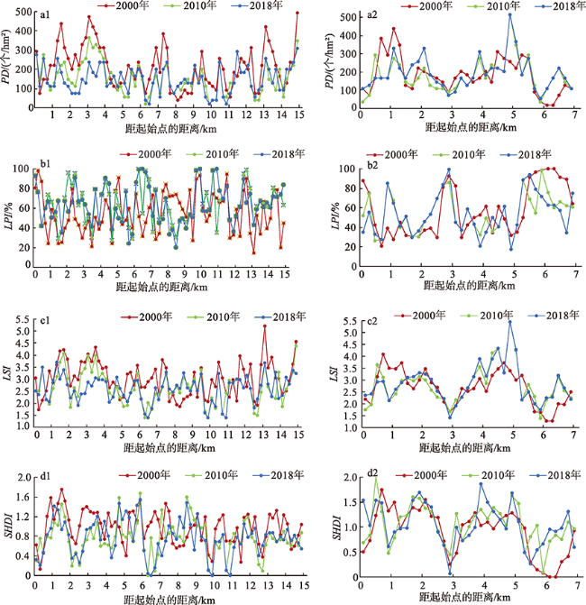
Fig. 6 Landscape index changes of transect a and transect e in valley area图6 河谷地区样带a和样带e景观指数变化图 |
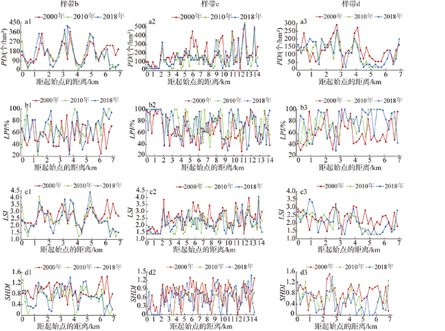
Fig. 7 Landscape index changes of b-d in mountainous and hilly regions图7 山地丘陵地区样带b~d的景观指数变化图 |
Fig. 8 Evolution of rural landscape patterns图8 乡村景观格局演变 |
Fig. 9 The driving mechanism of gradient evolution of landscape patterns in the study area图9 研究区景观格局梯度演变的驱动机制 |
| [1] |
[
|
| [2] |
Rural housing land accounted for 67.3% of China's total construction land in 2000. While there are numerous studies analyzing the loss of arable land due to urban sprawl, less attention has been paid to the study of rural housing land in China. This paper develops a theoretical framework for rural housing land transition in China. It introduces a research method, which is using the spatial differentiation in regional development for compensating the deficiencies in time-series data, to analyze the rural housing land transition in the Transect of the Yangtse River (TYR). Detailed land-use data and socio-economic data from both research institutes and government departments were used to test the following hypothesis on rural housing land transition. We assume that rural housing in every region will undergo specific stages—the proportion of rural housing in the increase of total construction land will decline gradually with the development of the local economy, and the end of the transition corresponds to a new equilibrium between rural housing and other construction activities. Five regional types of rural housing land change were defined according to an aggregation index used to reflect landscape patterns. The outcomes indicated that the share of rural housing in the increase of total construction land declines gradually from the upper reaches to the lower reaches of the Yangtse River, i.e. from Ganzi–Yushu to Luzhou–Diqing, Enshi–Chongqing, Tongling–Yichang and to Shanghai–Chaohu. Each region is in a different phase of the rural housing land transition, which corresponds to a particular socio-economic developmental level. Finally, some policy implications were discussed by applying this research to land management issues. The authors argue that there are problems in the current rural housing land managerial system in China, and that the Central Government needs to define uniform regulations for rural housing according to regional socio-economic developmental level, physical conditions and rural housing land transition phase. ]]> |
| [3] |
[
|
| [4] |
|
| [5] |
The concept of land use transition highlights that land use change is non-linear and is associated with other societal and biophysical system changes. A transition in land use is not a fixed pattern, nor is it deterministic. Land use transitions can be caused by negative socio-ecological feedbacks that arise from a depletion of key resources or from socio-economic change and innovation that take place rather independently from the ecological system. Here, we explore whether the sources of land use transitions are mostly endogenous socio-ecological forces or exogenous socio-economic factors. We first review a few generic pathways of forest transition as identified in national case studies, and evaluate the varying ecological quality of expanding forests associated with these pathways. We then discuss possible explanatory frameworks of land use transitions. We use the case of the recent forest transition in Vietnam as an illustration. Socio-ecological feedbacks seem to better explain a slowing down of deforestation and stabilization of forest cover, while exogenous socio-economic factors better account for reforestation. We conclude by discussing the prospects of accelerating land use transitions in tropical forest countries. ]]> |
| [6] |
|
| [7] |
[
|
| [8] |
|
| [9] |
|
| [10] |
[
|
| [11] |
|
| [12] |
|
| [13] |
[
|
| [14] |
|
| [15] |
|
| [16] |
|
| [17] |
[
|
| [18] |
[
|
| [19] |
[
|
| [20] |
[
|
| [21] |
[
|
| [22] |
[
|
| [23] |
[
|
| [24] |
|
| [25] |
The combined method of urban gradient analysis and landscape metrics in analyzing the changes of landscape pattern has been widely applied since its introduction by Luck and Wu (2002). In order to address the temporal dynamics of landscape change, this study integrated transect analysis with temporal trend analysis and specifically discussed how changes of residential pattern are related to forms of urban growth. Using Dane County, Wisconsin, USA as an example, a 60 km transect passing through the City of Madison was set up to represent a continuum of rural-urban-rural landscapes. Changes of landscape pattern from 1968 to 2000 were analyzed by FRAGSTATS with four metrics—percentage of landscape (PLAND), Shannon's evenness index (SHEI), patch density (PD), and mean patch size (MPS). Findings from metric analyses revealed that the degree of land-use diversity and landscape fragmentation is positively related to the degree of urbanization. Specifically, at the class-level, residential land-use type shows the strongest positive relationship to the degree of urbanization in all of the class-level metrics adopted. Changes in residential land-use pattern were further analyzed with the number of housing units. The analyses revealed that there are different patterns of residential development along the transect in the study area—with the core urban area expanding outward in a contiguous manner while the rural areas have scattered development. This study demonstrated the additional insights into landscape change by integrating the spatial and the temporal perspectives and by targeting the forms of residential developments. ]]> |
| [26] |
[
|
| [27] |
|
| [28] |
[
|
| [29] |
[
|
| [30] |
[
|
| [31] |
|
| [32] |
[
|
| [33] |
[
|
| [34] |
[
|
| [35] |
[
|
| [36] |
|
| [37] |
|
| [38] |
[
|
| [39] |
[
|
| [40] |
The role of agricultural change in transforming Greek rural landscapes is analysed within the broader context and theory of agricultural transition from traditional to productivist and post-productivist regimes. The analysis is based on remote sensing data following a case study approach in two study sites – Tymfi and Konitsa – located in the Epirus mountain area. Vegetation maps were created for 1945, 1969 and 1995 via ‘object oriented image analysis’ of a series of air-photographs. A number of landscape metrics was then calculated for each map and the interpreted spatial analysis illustrates that the observed landscape changes are linked to agricultural restructure. During the post war period when agriculture in Western Europe had entered a productivist phase, agricultural change was marked by trends of agricultural abandonment predominantly evident in the upland areas. In contrast, farming persisted at the lowlands and the gradual aggregation of crop fields in few large patches, indicates the existence of productivist agriculture. This landscape transformation suggests that productivist agriculture and land abandonment can coexist in a spatially differentiated pattern. Although since the mid-1980s, the rationale of agricultural policy priorities shifted towards post-productivism, the findings of this study do not support the existence of such a transition. The results are further discussed within the broader context of agricultural change in Europe providing an additional dimension to the discussions regarding the spatio-temporal properties of agricultural transition. Understanding the process of agricultural change could enhance the role of agricultural policy as a tool for landscape management and regional planning. ]]> |
| [41] |
[
|
| [42] |
|
| [43] |
[
|
| [44] |
|
| [45] |
|
| [46] |
|
| [47] |
[
|
| [48] |
[
|
| [49] |
[
|
| [50] |
[
|
/
| 〈 |
|
〉 |

