
中国阿牙克库木湖水量变化及其驱动机制
作者简介:陈军(1984- ),男,安徽宣城人,博士,高级工程师,研究方向为遥感地学分析、资源环境遥感。E-mail: gischen@126.com
收稿日期: 2018-12-03
要求修回日期: 2019-03-22
网络出版日期: 2019-06-20
基金资助
安徽省教育厅高校自然科学研究项目(KJ2018JD08)
国家自然科学基金项目(41371391)
The changes in the water volume of Ayakekumu Lake based on satellite remote sensing data
Received date: 2018-12-03
Request revised date: 2019-03-22
Online published: 2019-06-20
Copyright
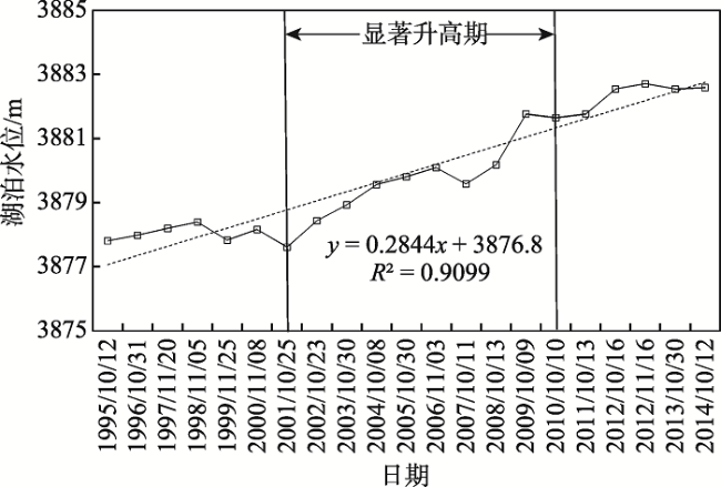
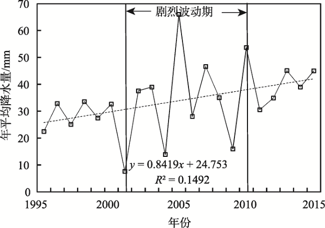
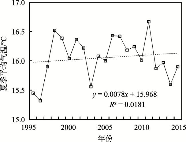
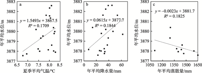
融合卫星雷达测高(T/P、RA-2和Hydroweb)与光学遥感数据分析了一个长时间序列的阿牙克库木湖水位及面积变化趋势,并基于NDSI和监督分类的方法提取了湖泊补给冰川的面积。结果表明:阿牙克库木湖在监测期内逐年扩大,面积由1995年的624 km2逐年扩张到2015年的995 km2,在此期间水位总共上升了5 m。气温升高导致补给冰川持续消融,冰川面积由1994年的361.27 km2退缩到2016年的345.26 km2。区域气候的暖湿化是1995-2015年阿牙克库木湖水量增加的主要背景,流域降水量的增加对湖泊水位上升产生直接驱动,持续升高的气温导致的补给冰川消融对湖泊扩张具有重要的促进作用。此外,最大可能蒸散、高海拔降水(雪)、冻土融化等因素也对湖泊的扩张产生重要影响。总之,准确掌握阿牙克库木湖的水量及其对气候变化的响应,对深刻理解青藏高原北部边缘的水资源平衡研究具有重要意义。
陈军 , 汪永丰 , 郑佳佳 , 曹立国 . 中国阿牙克库木湖水量变化及其驱动机制[J]. 自然资源学报, 2019 , 34(6) : 1331 -1344 . DOI: 10.31497/zrzyxb.20190618
A long time series of the Ayakekumu Lake level change has been compiled by combination of the T/P, RA-2 and Hydroweb data. In addition, we assessed changing index of the Ayakekumu Lake during 1995-2015 based on Landsat images. The results showed that, the Ayakekumu Lake area and level increased continuously during the observation period, the area of lake increased from 624 km2 in 1995 to 995 km2 in 2015, and water level increased by 5 m in total in the period of 1995-2015. Meanwhile, the air temperature had risen, and the area of glaciers retreated from 361.27 km2 in 1994 to 345.26 km2 in 2016. We concluded that the water volume change was related with climate factors, and the main factor was warm-wet climate. Additionally, atmosphere warning led to water level increase due to glaciers melting. The water volume changing in Ayakekumu Lake could be affected by the increasing precipitation as well as dropping evaporation. Some factors are likely to affect lake expansion, including permafrost melting and precipitation at high altitudes. In sum, accurate measurements of lake ice and water levels are critical for understanding the water resource balance and hydrologic cycle in arid or semi-arid regions of China.
Key words: Ayakekumu Lake; radar altimetry; lake extent; water level; climate change
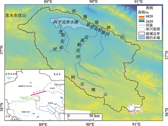
Fig. 1 Location of the study area on the Tibetan Plateau图1 研究区位置 |
Fig. 2 The valid data combined from three radar altimetry data图2 基于卫星雷达测高的有效高程数据组合 |
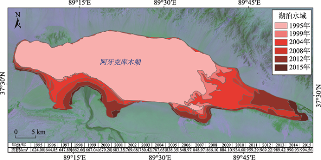
Fig. 3 The spatiotemporal changes of Ayakekumu Lake during 1995-2015 derived from Landsat image图3 基于Landsat影像的1995-2015年阿牙克库木湖时空变化 |
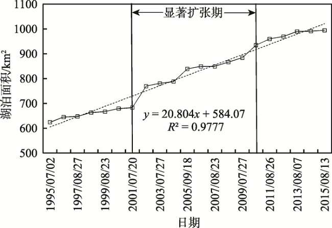
Fig. 4 The lake area time series of Ayakekumu Lake during 1995-2015 derived from Landsat images图4 基于Landsat影像的1995-2015年阿牙克库木湖面积时间序列 |
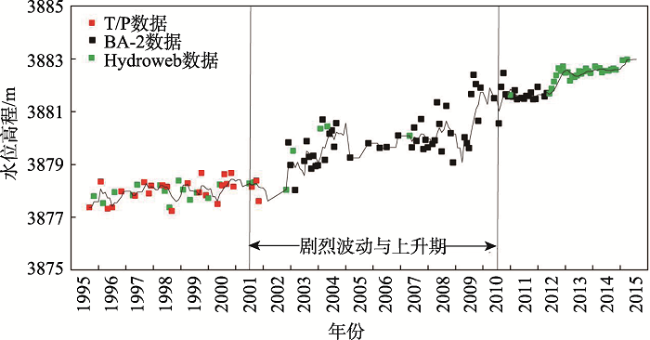
Fig. 5 The lake level time series of Ayakekumu Lake during 1995-2015 derived from radar altimetry图5 基于雷达测高的1995-2015年阿牙克库木湖水位时间序列 |
Fig. 6 Change trend of annual precipitation over Ayakekumu Lake basin during 1995-2015图6 1995-2015年阿牙克库木湖流域年平均降水量变化 |
Fig. 7 Change trend of summer air temperature over Ayakekumu lake basin during 1995-2015图7 1995-2015年阿牙克库木湖流域夏季平均气温变化 |
Fig. 8 The relationship between annual lake level and summer average temperature, precipitation, and evaporation, respectively图8 湖泊年平均水位与夏季平均气温、年平均降水量、年平均蒸发量的互相关性分析 |
The authors have declared that no competing interests exist.
| [1] |
[
|
| [2] |
|
| [3] |
|
| [4] |
|
| [5] |
|
| [6] |
[
|
| [7] |
[
|
| [8] |
[
|
| [9] |
[
|
| [10] |
|
| [11] |
[
|
| [12] |
|
| [13] |
[
|
| [14] |
[
|
| [15] |
[
|
| [16] |
[
|
| [17] |
[
|
| [18] |
|
| [19] |
[
|
| [20] |
[
|
| [21] |
[
|
| [22] |
|
| [23] |
|
| [24] |
[
|
| [25] |
|
| [26] |
|
| [27] |
|
| [28] |
[
|
| [29] |
|
| [30] |
|
| [31] |
[
|
| [32] |
|
| [33] |
|
| [34] |
|
| [35] |
|
| [36] |
[
|
| [37] |
[
|
| [38] |
|
| [39] |
KROPÁCEK, J, MAUSSION, F, CHEN, F, et al. Analysis of ice phenology of lakes on the Tibetan Plateau from MODIS data. Cryosphere, 2013, 7(1): 287-301.
|
| [40] |
|
| [41] |
[
|
| [42] |
[
|
| [43] |
[
|
| [44] |
[
|
| [45] |
[
|
| [46] |
[
|
| [47] |
[
|
| [48] |
[
|
| [49] |
[
|
| [50] |
|
| [51] |
|
| [52] |
[
|
/
| 〈 |
|
〉 |