
中国采煤沉陷区空间格局与治理模式
作者简介:李佳洺(1984- ),男,山西晋城人,博士,助理研究员,研究方向为经济地理与区域发展。E-mail: lijm@igsnrr.ac.cn
收稿日期: 2018-04-25
要求修回日期: 2018-08-11
网络出版日期: 2019-04-20
基金资助
国家自然科学基金项目(41701128,41671166)
中国科学院重点部署项目(KFZD-SW-314)
Spatial distribution and governance of coal-mine subsidence in China
Received date: 2018-04-25
Request revised date: 2018-08-11
Online published: 2019-04-20
Copyright
大面积的采煤沉陷区引发严重的社会和环境问题,得到政府和学术界的广泛关注。与传统以自然条件为基础的沉陷区复垦研究不同,考虑采煤沉陷区自然生态因素和区域经济发展条件,从综合治理的角度出发,分析中国采煤沉陷区整体格局和面临的社会经济风险,深入研究各地采煤沉陷区综合治理路径。结果表明:中国采煤沉陷区面积预计超过60000 km2,其中与城乡建设用地和耕地叠压的面积分别达到4500 km2和26000 km2,涉及人口达2000万左右,其中山西和山东两省采煤沉陷区的影响最为严重;从区域特征来看,中国采煤沉陷区有开发利用、环境修复、民生保障、异地搬迁四大主要治理导向,进一步结合社会经济和空间特征,可以将沉陷区分为环境适应发展型、基础设施完善型、特色产业带动型、环境修复型、民生保障型、异地搬迁型六个治理类型。
李佳洺 , 余建辉 , 张文忠 . 中国采煤沉陷区空间格局与治理模式[J]. 自然资源学报, 2019 , 34(4) : 867 -880 . DOI: 10.31497/zrzyxb.20190415
Coal has been China's dominant indigenous source of energy. Although the proportion of coal consumption in total (primary) energy consumption decreased steadily in recent years, China is still the world's largest coal producer and has been exporting substantial amounts of the energy. Due to a long history of underground coal mining, many more undermined areas have subsided than most people can imagine. Large coal-mine subsidence has resulted in serious structural damage to buildings, roads, irrigation ditches, underground utilities and pipelines. Besides, the consequences of ground subsidence generally consist of serious environment impact and livelihoods issues of residents. All these has drawn a lot of attention from scholars and government leaders. However, it still fails to figure out the whole picture of coal-mine subsidence and its consequences in China. The research has employed a unique dataset of mineral rights for coal in China to investigate spatial distribution of subsidence at present and foreseeable future. The damage to cities and farmland and the size of population involved in the subsidence areas has also been estimated through the comprehensive analysis of land use map and population and subsidence distribution. The results highlight the difference of potential losses of coal-mine subsidence between areas in China. For example, subsidence has significant influence on urban development in eastern China; while farmland in rural areas suffers relatively great loss in the western mountainous areas. Even so, it is not enough to answer how to govern and mitigate subsidence of those large coal-mines in China. Because governance modes and methods depend on not only characteristics of spatial distribution and potential losses but also natural conditions and the level of economic development. According to characteristics of potential losses, natural conditions and economic development, we further define six kinds of subsidence and figure out their governance directions and major works in China. The results are shown in the following: (1) The area of potential coal-mine subsidence is more than 60000 km2 in China. There are 4500 km2 of the urban-rural construction land and 26000 km2 of farmland in these subsiding areas. There are around 20 million residents involved in the subsidence. (2) According to climatic conditions and social and economic development levels, coal-mine subsidences fall into four types of areas with different governance directions in China: Focusing on eco-environmental modification; household livelihood security; exploitation and utilization; migration and relocation. (3) According to population and construction lands impacted and hydrogeological environment, exploitation-oriented areas are further divided into three types: Some should adapt to the changing environment; some should repair the infrastructures destroyed; some should develop characteristic industries such as tourism to increase residents' income.
Key words: coal-mine subsidence areas; spatial characteristics; governance; China
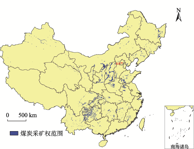
Fig. 1 The spatial distribution of mineral rights in China图1 中国煤炭采矿权空间分布及其范围|||注:本图基于国家测绘地理信息服务局标准地图服务网站下载的审图号为GS(2016)1570标准地图制作,底图无修改,下同。 |
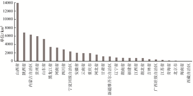
Fig. 2 The areas of mineral rights of each province in China图2 中国各省(市、自治区)采矿权的区域面积 |
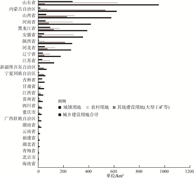
Fig. 3 The areas of mining and construction land overlaying in China图3 中国各省(市、自治区)矿区与城乡建设用地相互叠压区域空间范围 |
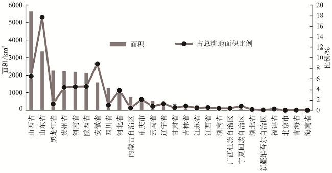
Fig. 4 The areas of mining and cultivated land overlaying in China图4 中国各省(市、自治区)矿区与耕地相互叠压区域空间范围 |
Table 1 Population in coal-mine subsidence in China表1 中国采煤沉陷区涉及人口估算结果 |
| 省份 | 2010年 | 2015年 | ||
|---|---|---|---|---|
| 最小人口规模/万人 | 最大人口规模/万人 | 最小人口规模/万人 | 最大人口规模/万人 | |
| 山东省 | 426 | 508 | 436 | 521 |
| 山西省 | 233 | 329 | 239 | 337 |
| 河南省 | 171 | 209 | 176 | 214 |
| 安徽省 | 143 | 176 | 147 | 181 |
| 黑龙江省 | 135 | 169 | 139 | 173 |
| 河北省 | 126 | 157 | 129 | 161 |
| 贵州省 | 95 | 133 | 97 | 136 |
| 辽宁省 | 69 | 89 | 71 | 91 |
| 陕西省 | 47 | 82 | 49 | 84 |
| 四川省 | 63 | 82 | 65 | 84 |
| 内蒙古自治区 | 45 | 76 | 46 | 78 |
| 重庆市 | 44 | 58 | 46 | 60 |
| 江苏省 | 46 | 58 | 47 | 59 |
| 湖南省 | 42 | 56 | 43 | 57 |
| 广西壮族自治区 | 39 | 49 | 40 | 50 |
| 吉林省 | 37 | 47 | 38 | 48 |
| 云南省 | 34 | 45 | 34 | 46 |
| 江西省 | 25 | 32 | 26 | 33 |
| 湖北省 | 12 | 18 | 13 | 19 |
| 甘肃省 | 12 | 18 | 13 | 18 |
| 福建省 | 6 | 10 | 6 | 10 |
| 新疆维吾尔自治区 | 4 | 8 | 4 | 8 |
| 宁夏回族自治区 | 5 | 8 | 5 | 8 |
| 青海省 | 3 | 4 | 3 | 4 |
| 北京市 | 0 | 1 | 0 | 1 |
| 总人口规模 | 1862 | 2422 | 1912 | 2481 |
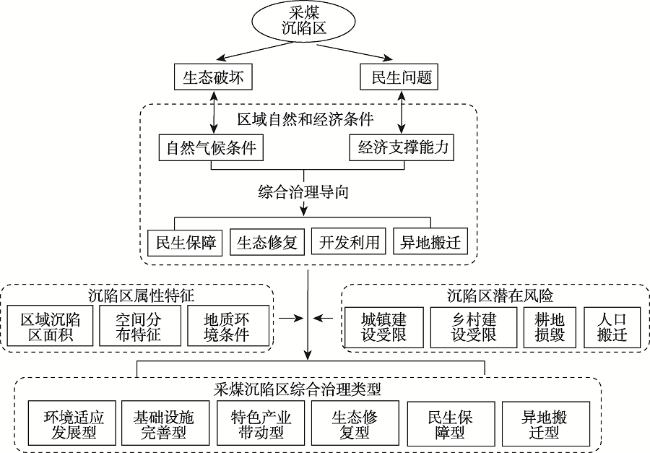
Fig. 5 Analysis framework of comprehensive management for coal-mine subsidence图5 采煤沉陷区综合治理分析框架 |
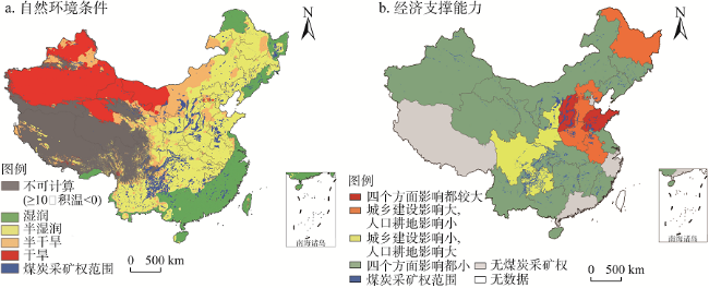
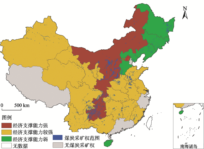
Fig. 6 Natural and economic conditions of coal-mine subsidence in China图6 中国采煤沉陷区区域尺度自然和经济条件 |
Table 2 The orientation of management of coal-mine subsidence in China表2 中国采煤沉陷区区域综合治理的导向分析 |
| 区域综合治理主导方向 | 自然和经济特征 | 主要区域 |
|---|---|---|
| 开发利用 | 自然气候条件和经济支撑能力都较好 | 北京、安徽、山东、江苏、山西、河南、福建、广西、四川、重庆、贵州、湖北、湖南、江西、云南 |
| 生态修复 | 自然气候条件差,经济支撑能力弱 | 内蒙古、陕西、宁夏、甘肃、青海、新疆、西藏 |
| 民生保障 | 自然气候条件好,经济支撑能力较强 | 黑龙江、吉林、辽宁、河北、海南 |
| 异地搬迁 | 自然气候条件和经济支撑能力都差 |
Fig. 7 Social and economic risks of coal-mine subsidence in China图7 中国采煤沉陷区社会经济风险 |
Table 3 Classification systems of coal-mine subsidence in China表3 采煤沉陷治理区分类体系 |
| 大类 | 开发利用主导型 | 环境修复主导型 | 民生保障主导型 | 异地搬迁主导型 | |||
|---|---|---|---|---|---|---|---|
| 亚类 | 环境适应 发展型 | 基础设施 完善型 | 特色产业 带动型 | 环境修复型 | 民生保障型 | 异地搬迁型 | |
| 主要 特征 | 区域 特征 | 气候湿润,经济支撑能力强 | 气候湿润,经济支撑能力强 | 气候湿润,经济支撑能力强 | 气候干旱,经济支撑能力强 | 气候湿润,经济支撑能力弱 | 生态环境和经济支撑能都较差,或居民生命财产受到威胁 |
| 区块社会经济特征 | 叠压城乡建设用地较多 | 叠压城乡建设用地较多 | 涉及人口和耕地较多 | 社会经济影响小 | 社会经济影响小,或仅叠压城乡建设用地较多 | ||
| 区块空间特征 | 地下水位较高,沉陷区空间集中 | 沉陷区空间 集中 | 以山地为主,沉陷区较为 分散 | 沉陷区空间集中 | 沉陷区空间 集中 | ||
| 治理 方式 | 整治沉陷区景观环境,积极适应发展环境变化 | 完善基础设施,保障居民基本生活 | 结合旅游等特色产业或扶贫项目等促进沉陷区治理 | 以生态环境修复为主,结合发展环境友好型产业 | 推进棚户区改造,加强土地复垦 | ||
| 主要 区域 | 山东西部、安徽北部、江苏北部等两淮 地区 | 山西、河南等中部地区 | 贵州、陕西、四川、云南、重庆等西南 地区 | 内蒙古、新疆、陕西、甘肃、宁夏等西北地区 | 黑龙江、吉林、辽宁、河北等地区 | ||
The authors have declared that no competing interests exist.
| [1] |
[
|
| [2] |
[
|
| [3] |
[
|
| [4] |
[
|
| [5] |
[
|
| [6] |
[
|
| [7] |
[
|
| [8] |
[
|
| [9] |
[
|
| [10] |
[
|
| [11] |
[
|
| [12] |
[
|
| [13] |
[
|
| [14] |
[
|
| [15] |
[
|
| [16] |
[
|
| [17] |
[
|
| [18] |
[
|
| [19] |
[
|
| [20] |
[
|
| [21] |
[
|
/
| 〈 |
|
〉 |