
基于MCR模型的大别山核心区生态安全格局异质性及优化
作者简介:黄木易(1978- ),男,安徽芜湖人,博士,副教授,主要从事城镇化、流域生态环境的空间信息挖掘及耦合模型研究。E-mail: huangyang78@163.com
收稿日期: 2018-12-07
要求修回日期: 2019-02-19
网络出版日期: 2019-04-20
基金资助
国家社会科学基金重点项目(14AZD124)
安徽高校人文社会科学研究重大项目(SK2018ZD043)
安徽省哲学社会科学规划项目(AHSKQ2016D23)
安徽省科技创新战略与软科学研究项目(201806a02020046)
Analysis of spatial heterogeneity of ecological security based on MCR model and ecological pattern optimization in the Yuexi county of the Dabie Mountain Area
Received date: 2018-12-07
Request revised date: 2019-02-19
Online published: 2019-04-20
Copyright
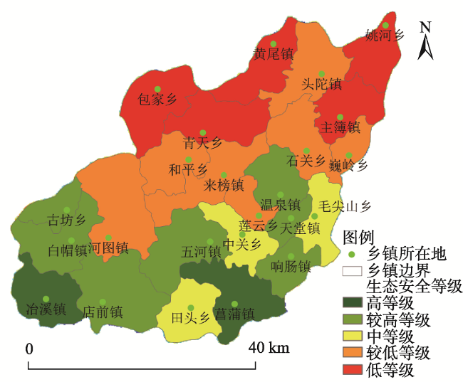
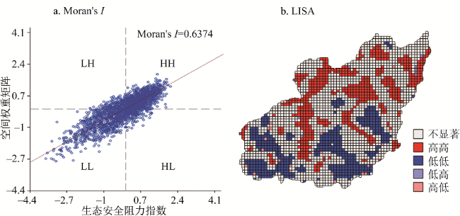
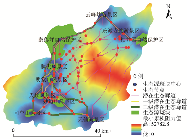
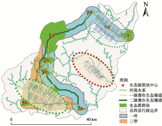
以大别山核心区精准扶贫对象岳西县为研究单元,选择10个生态阻力因子建立生态安全评价指标体系,利用ArcGIS构建生态阻力面,应用空间数据探索分析方法(Exploratory Spatial Data Analysis,ESDA)、最小累积阻力模型(Minimum Cumulative Resistance,MCR)和重力模型对生态安全进行诊断和潜在生态廊道识别提取。研究表明:(1)岳西县生态安全较高及高等级区域占县域总面积37.79%,而较低及低等级区域占51.89%,整体呈现北低南高的空间特征,生态安全水平总体偏低。(2)ESDA分析显示,生态安全空间分布全局Moran's I指数为0.6374,LISA图显示岳西县生态安全等级主要以高高(HH)、低低(LL)两种聚集类型为主,在空间上呈明显的片状集聚分布特征。在此基础上,选择生境良好的自然保护区及大型风景区斑块为生态源,生成累积耗费阻力面,基于MCR最小累积阻力模型构建生态源之间的最小累积耗费路径,提取潜在生态廊道90条,生态节点103个,利用重力模型识别出21条重要潜在生态廊道,其中,一级和二级潜在生态廊道分别为13条和8条。(3)结合岳西县旅游产业空间发展规划,提出了“一环三带”生态网络框架空间布局模式及优化对策,该模式可作为岳西县生态经济产业发展格局的有效补充。
黄木易 , 岳文泽 , 冯少茹 , 蔡接接 . 基于MCR模型的大别山核心区生态安全格局异质性及优化[J]. 自然资源学报, 2019 , 34(4) : 771 -784 . DOI: 10.31497/zrzyxb.20190408
Taking Yuexi county, the core area of Dabie Mountain, which is a focus in China's targeted poverty alleviation campaign, as the research unit, and based on remote sensing and GIS platform, we selected ten ecological resistance factors, namely, elevation, slope, land use type, vegetation coverage, soil erosion, and distance from tourist spot, industrial land, water area, road, residential areas, to establish an ecological security evaluation index system. With the aid of ArcGIS, ecological security level was evaluated and potential ecological corridor recognition was extracted, through Exploratory Spatial Data Analysis (ESDA) method, Minimum Cumulative Resistance (MCR) model and gravity model, to build ecological resistance. The results showed that: The high and higher level regions accounted for 37.79% of the total area of the county, while the low and lower ranking regions accounted for 51.89%, which present the spatial characteristics that the low level ecological security units were distributed in the north part, while the high level ones were in the south part, and that the overall ecological security level was relatively low in the county. Secondly, the spatial distribution characteristics of ecological security by means of ESDA analysis method indicated that the global Moran's I index was 0.6374, and LISA figure showed that there were mainly high (HH) and low (LL) types of aggregation for ecological security level, and the ecological security had a significant spatial clustering characteristic in Yuexi county. On this basis, good habitat in the nature reserve and large scenic spot patches were chosen as the ecological source, which is the first step for ecological source cumulative cost resistance surface generated by cost distance tool of ArcGIS. Then, the minimum cumulative cost path and the potential ecological corridor were identified and constructed based on MCR model. The results showed that a total of 21 important potential ecological corridors and 103 ecological nodes were identified and extracted, including 13 first-level corridors and 8 secondary corridors by means of gravity model. Finally, according to the characteristics of the tourism poverty alleviation industry and ecological economic development in the study area, the paper put forward the layout model of "one ring and three zones" ecological corridor network framework and some optimization countermeasures. This model is an effective supplement to the development pattern of ecological economy industry in Yuexi county.
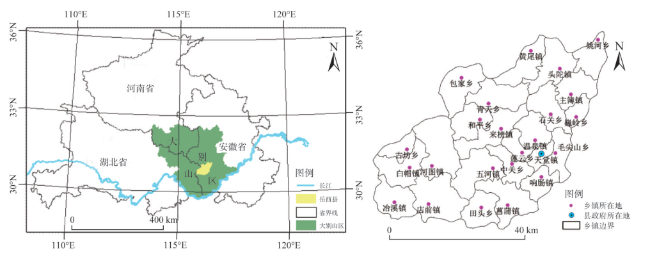
Fig. 1 Scope and location of the Yuexi County图1 岳西县范围及地理区位 |
Table 1 Classification of ecological security factors in Yuexi county表1 岳西县生态安全因子等级划分 |
| 评价因子 | 序号 | 分级参考 来源 | 单位 | 阻力值 | 权重 | |||
|---|---|---|---|---|---|---|---|---|
| 1级 | 2级 | 3级 | 4级 | |||||
| 高程 | A | 文献[24] | m | <200 | 200~400 | 400~600 | >600 | 0.150 |
| 坡度 | B | 文献[26] | ° | <7 | 7~15 | 15~25 | >25 | 0.200 |
| 土地利用类型 | C | 文献[23] | — | 林地 | 水域 | 农用地 | 建设用地 | 0.050 |
| 植被覆盖度 | D | 文献[27] | — | >65% | 50%~65% | 35%~50% | <35% | 0.150 |
| 土壤侵蚀 | E | 文献[28] | t·km-2·a-1 | <2500 | 2500~5000 | 5000~10000 | >10000 | 0.050 |
| 距景点距离 | F | 文献[24,29] | m | <1000 | 1000~5000 | >5000 | 0.005 | |
| 距工业用地距离 | G | 文献[22] | m | >1500 | 1000~1500 | 500~1000 | <500 | 0.045 |
| 距水体距离 | H | 文献[25] | m | <100 | 100~500 | 500~1000 | >1000 | 0.200 |
| 距道路距离 | I | 文献[30] | m | >2000 | 1000~2000 | 500~1000 | <500 | 0.100 |
| 距居民点距离 | J | 文献[22,30] | m | >1500 | 1000~1500 | 500~1000 | <500 | 0.050 |
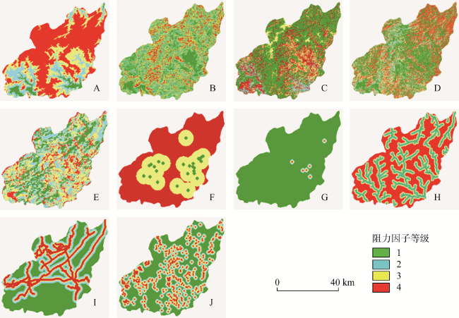
Fig. 2 Grade distribution of reclassification maps of ecological security factors in Yuexi county图2 岳西县生态安全阻力因子重分类等级图|||注:A:高程因子;B:坡度因子;C:土地利用类型因子;D:植被覆盖度因子;E:土壤侵蚀因子;F:距景点距离因子;G:距工业用地距离因子;H:距水体距离因子;I:距道路距离因子;J:距居民点距离因子。 |
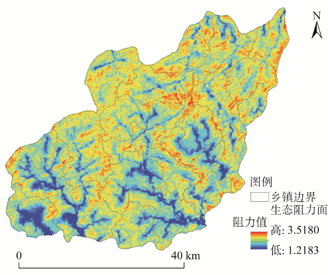
Fig. 3 Grid map of ecological resistance in Yuexi county图3 岳西县生态栅格阻力面 |
Fig. 4 Classification of ecological security in Yuexi county图4 岳西县生态安全等级划分 |
Fig. 5 The LISA aggregation of land ecological security evaluation index in Yuexi county图5 岳西县生态安全评价等级Moran's I散点图及LISA聚集图 |
Fig. 6 Grid map of cumulative cost distance for ecological sources and potential eco-corridors and eco-nodes图6 累积耗费阻力面、潜在生态廊道与节点分布 |
Table 2 Identification of the importance of potential ecological corridors in Yuexi county表2 岳西县潜在生态廊道重要性识别 |
| 重要 性值 | 生态源斑块 | ||||||||||
|---|---|---|---|---|---|---|---|---|---|---|---|
| 1 | 2 | 3 | 4 | 5 | 6 | 7 | 8 | 9 | 10 | ||
| 生态源斑块 | 1 | — | 220.7892 | 96.5339 | 57.4688 | 31.7698 | 47.9108 | 32.7094 | 58.6744 | 44.8643 | 29.8911 |
| 2 | — | — | 775.7783 | 200.6901 | 70.7435 | 118.2498 | 49.2884 | 30.1409 | 28.1914 | 20.4705 | |
| 3 | — | — | — | 600.5939 | 123.3771 | 267.0343 | 58.9505 | 22.0793 | 22.0166 | 18.0512 | |
| 4 | — | — | — | — | 388.4055 | 522.7442 | 64.3838 | 16.1716 | 16.1476 | 14.0607 | |
| 5 | — | — | — | — | — | 214.0658 | 58.4684 | 11.4995 | 11.4219 | 11.1292 | |
| 6 | — | — | — | — | — | — | 165.3681 | 19.9354 | 20.5207 | 19.0215 | |
| 7 | — | — | — | — | — | — | — | 15.1764 | 18.7530 | 21.8282 | |
| 8 | — | — | — | — | — | — | — | — | 203.1091 | 65.0220 | |
| 9 | — | — | — | — | — | — | — | — | — | 274.5304 | |
| 10 | — | — | — | — | — | — | — | — | — | — | |
注:(1)表中1~10数值表示各生态源斑块的序号,按顺序分别表示:1为“鹞落坪自然保护区”、2为“驮尖风景区”、3为“明堂山风景区”、4为“天峡风景区”、5为“司空山风景区”、6为“妙道山风景区”、7为“天仙河景区”、8为“云峰峡谷景区”、9为“乐诚寺旅游景区”、10为“枯井园自然保护区”;(2)表中重要性值在 [50,100] 区间的为二级廊道,大于100的为一级廊道,重要性小于50的为一般廊道。 |
Fig. 7 The map of ecological framework with layout of 'patch-corridor-point' in Yuexi county图7 岳西县生态网络框架空间布局 |
The authors have declared that no competing interests exist.
| [1] |
[
|
| [2] |
[
|
| [3] |
[
|
| [4] |
|
| [5] |
|
| [6] |
|
| [7] |
[
|
| [8] |
[
|
| [9] |
[
|
| [10] |
|
| [11] |
[
|
| [12] |
[
|
| [13] |
[
|
| [14] |
|
| [15] |
[
|
| [16] |
[
|
| [17] |
[
|
| [18] |
[
|
| [19] |
[
|
| [20] |
[
|
| [21] |
[
|
| [22] |
[
|
| [23] |
[
|
| [24] |
[
|
| [25] |
[
|
| [26] |
[
|
| [27] |
[
|
| [28] |
中华人民共和国水利部. SL190-1996土壤侵蚀分类分级标准. 北京: 中国水利水电出版社, 1997.
[Ministry of Water Resources of the People's Republic of China. SL 190-1996 Standards for Classification and Gradation of Soil Erosion. Beijing: China Water Conservancy and Hydropower Press, 1997.]
|
| [29] |
[
|
| [30] |
[
|
| [31] |
[
|
| [32] |
[
|
| [33] |
[
|
| [34] |
|
| [35] |
[
|
/
| 〈 |
|
〉 |