
塔里木河下游区域植被时空变化
作者简介:高庆(1989- ),男,安徽阜阳人,硕士,主要从事遥感应用研究。E-mail: gaoqing215@mails.ucas.ac.cn
收稿日期: 2018-07-03
要求修回日期: 2018-10-25
网络出版日期: 2019-03-28
基金资助
国家自然科学基金项目(31570536)
Spatiotemporal variation of vegetation in the lower reaches of Tarim River
Received date: 2018-07-03
Request revised date: 2018-10-25
Online published: 2019-03-28
Copyright
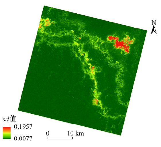
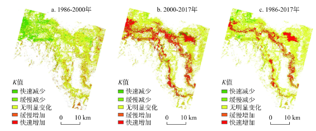
为了对比生态输水工程实施前后塔里木河下游植被变化,分析植被对生态输水的时空响应,基于1986-2017年研究区上方无云的22期Landsat NDVI数据,辅以波动分析、趋势分析,探索研究区植被的时空变化特征,并对其驱动因素进行分析。结果表明:(1)空间上,植被的分布与水资源的分布密切相关,主要沿河道和积水区域分布。(2)1986-2000年,NDVI呈现缓慢下降趋势,2000-2017年NDVI总体呈现波动增加趋势;植被对生态输水有一定的滞后性,且与输水量密切相关。(3)研究区NDVI时间序列的方差介于0.0077~0.1957间,存在明显的空间差异,其波动的大小与植被种类密切相关。(4)1986-2000年,植被的NDVI空间趋势以减小为主,并主要发生在英苏和老英苏附近;2000-2017年,植被的NDVI空间趋势以增加为主,且主要发生在沿河道区域和喀尔达依东侧。
关键词: 植被变化; Landsat NDVI; 时间序列; 塔里木河下游
高庆 , 艾里西尔·库尔班 , 肖昊 . 塔里木河下游区域植被时空变化[J]. 自然资源学报, 2019 , 34(3) : 624 -632 . DOI: 10.31497/zrzyxb.20190315
To examine the spatiotemporal variation of vegetation in the lower reaches of the Tarim River, in this study, we use the cloud-free data of Landsat 5 TM and Landsat 8 OLI to obtain 22 time-series NDVI data during the period 1986-2017. We use the standard deviation of the NDVI time series to reflect vegetation change and the slope of linear regression equation of NDVI time series to reflect the variation tendency of vegetation. The results show that: (1) The distribution of vegetation is closely related to the distribution of water resources, mainly along the river channel and the water logged area. (2) For 1986-2000, the average NDVI value in the range within 1 km from the river channel fluctuated around 0.055, and showed a trend of slow decline because of the long-term absence of water supply. For 2000-2017, the average NDVI value showed an increasing trend and its fluctuation was closely related to volume and allocation of ecological water transportation. (3) The variance of NDVI time series in the study area was between 0.0077-0.1957, and there was obvious spatial difference. Its fluctuation was closely related to vegetation species. (4) The vegetation was in decline, which mainly occurred in the vicinity of Yingsu and old Yingsu during 1986-2000, but the vegetation mainly presented an increasing trend, and occurred mainly in the area along the river and east of Ka'erdayi during 2000-2017.
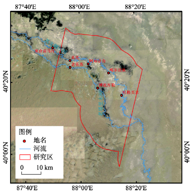
Fig. 1 Study area图1 研究区 |
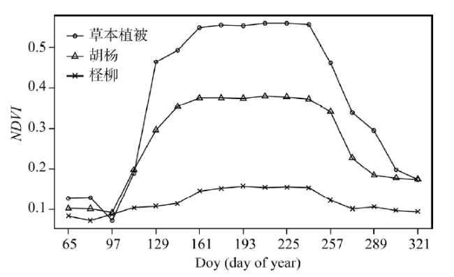
Fig. 2 NDVI changes main vegetation in the study area during the year图2 研究区主要植被年内NDVI变化 |
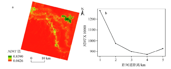
Fig. 3 Spatial distribution of NDVI in the study area图3 研究区NDVI空间分布 |
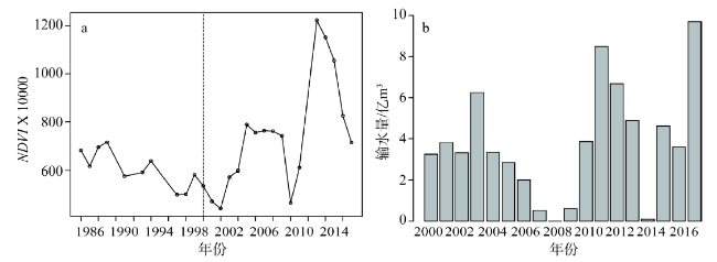
Fig. 4 Temporal variation of NDVI during 1986-2017 and ecological water transportation volume during 2000-2017图4 1986-2017年NDVI变化及2000-2017年生态输水量 |
Fig. 5 Fluctuation of NDVI from 1986 to 2017图5 1986-2017年NDVI波动强度 |
Fig. 6 Variation trend of NDVI in different time spans图6 不同时间跨度NDVI变化趋势 |
The authors have declared that no competing interests exist.
| [1] |
[
|
| [2] |
[
|
| [3] |
[
|
| [4] |
[
|
| [5] |
|
| [6] |
|
| [7] |
|
| [8] |
[
|
| [9] |
[
|
| [10] |
[
|
| [11] |
|
| [12] |
|
| [13] |
吐尔逊·哈斯木, 曼尼萨汗·吐尔隼,
[
|
| [14] |
[
|
| [15] |
[
|
| [16] |
[
|
| [17] |
[
|
| [18] |
[
|
| [19] |
吐尔逊·哈斯木,
[
|
| [20] |
[
|
| [21] |
[
|
| [22] |
[
|
| [23] |
[
|
| [24] |
[
|
| [25] |
[
|
| [26] |
[
|
| [27] |
古丽·加帕尔,
[
|
| [28] |
|
/
| 〈 |
|
〉 |