 PDF(2365 KB)

青海湖沙柳河流域不同时期地表水与地下水的相互作用
雷义珍, 曹生奎, 曹广超, 杨羽帆, 兰垚, 季雨桐, 李华非
自然资源学报 ›› 2020, Vol. 35 ›› Issue (10) : 2528-2538.
PDF(2365 KB)
PDF(2365 KB)
青海湖沙柳河流域不同时期地表水与地下水的相互作用
Study on surface water and groundwater interaction of Shaliu River Basin in Qinghai Lake in different periods
 ({{custom_author.role_en}}), {{javascript:window.custom_author_en_index++;}}
氢氧稳定同位素技术是研究地表水和地下水相互作用的有效手段。依据青海湖沙柳河流域2018年消融期、多雨期和冰冻期所收集的降水、河水和地下水样品中对氢氧同位素组成(δD、δ18O)的测定结果,识别和量化不同时期高山草原带和高山草甸带地表水和地下水间的补给关系和比例,其目的旨在明确高寒内陆河流域地表水和地下水δD和δ18O受降水影响的时空差异。结果表明:青海湖沙柳河流域地表水和地下水δD和δ18O值受降水响应存在时空差异性,δD和δ18O值在消融期受降水影响最强,冰冻期最弱;在高山草甸带δD和δ18O值受降水的影响强于高山草原带。消融期的高山草甸带、高山草原带和冰冻期的高山草原带地表水补给地下水的比例分别为80.65%、93.36%和89.44%;多雨期的高山草甸带、高山草原带和冰冻期的高山草甸带地下水补给地表水的比例分别为44.50%、74.85%和88.58%。研究结果可为该流域水资源优化配置和管理提供科学依据。
Hydrogen and oxygen stable isotope technology is an effective method to study the surface water-groundwater interaction. Based on the hydrogen and oxygen isotope component (δD and δ18O) of precipitation, river water and groundwater collected in the Shaliu River Basin of Qinghai Lake during ablation period, rainy period and freezing period in 2018, the paper aims to clarify the spatio-temporal differences between δD and δ18O values of surface water and groundwater under the influence of precipitation. We use the two-component method to reveal and ensure the interaction between surface water and groundwater of alpine steppe zone and alpine meadow zone in three periods. Results show that, the impact of precipitation on surface water and groundwater is different in space and time. Stable isotopic response of surface water and groundwater to precipitation on the time is the strongest in ablation period and the weakest in freezing period. And the stable isotopic response of surface water and groundwater to precipitation in alpine meadow zone is stronger than that in alpine steppe zone. In alpine meadow and alpine steppe zones of ablation period and alpine steppe zone of freezing period, surface water recharges groundwater, and the ratio is 80.65%, 93.36% and 89.44%, respectively. In alpine meadow and alpine steppe zones of ablation period and alpine meadow zone of freezing period, groundwater recharges surface water, and the ratio is 44.50%, 74.85% and 88.58%, respectively. Thus, this study provides a scientific basis for the optimization, allocation and management of water resources.
青海湖 / 沙柳河流域 / 氢氧稳定同位素 / 地表水 / 地下水 / 相互作用 {{custom_keyword}} /
Qinghai Lake / Shaliu River Basin / stable isotopes of hydrogen and oxygen / surface water / groundwater / interaction {{custom_keyword}} /
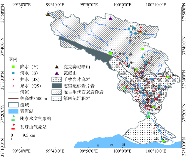
图1 研究区地层[21]和采样点分布Fig. 1 The stratigraphic distribution and sampling point distribution of the Shaliu River Basin |
表1 不同时期青海湖沙柳河流域高山草原带各水体δD和δ18O值Table 1 The δD and δ18O values of different water bodies of alpine steppe zone in Shaliu River Basin in different periods |
| 水体 | 月份 | n | δD/‰ | δ18O/‰ | |||||
|---|---|---|---|---|---|---|---|---|---|
| min | mean/SE | max | min | mean/SE | max | ||||
| 降水 | 4月 | 4 | -64.40 | -37.94/23.10 | -8.84 | -10.78 | -6.96/2.73 | -4.30 | |
| 8月 | 5 | -77.34 | -69.95/7.36 | -59.46 | -11.62 | -10.52/0.91 | -9.46 | ||
| 11月 | 5 | -129.59 | -100.59/17.00 | -87.41 | -18.14 | -15.13/1.75 | -13.79 | ||
| 河水 | 4月 | 12 | -43.59 | -37.85/3.02 | -34.67 | -7.27 | -6.34/0.45 | -5.83 | |
| 8月 | 15 | -54.80 | -45.12/3.99 | -40.36 | -9.63 | -8.78/0.60 | -6.68 | ||
| 11月 | 14 | -48.96 | -44.03/2.20 | -41.52 | -8.13 | -7.46/038 | -7.02 | ||
| 地下水 | 4月 | 21 | -45.30 | -39.70/4.43 | -23.91 | -7.15 | -6.46/0.49 | -5.07 | |
| 8月 | 23 | -50.34 | -40.93/3.31 | -36.68 | -7.96 | -6.61/0.48 | -5.84 | ||
| 11月 | 25 | -55.53 | -45.83/5.37 | -36.18 | -10.21 | -8.27/1.47 | -6.07 | ||
| 注:min、mean/SE和max分别代表最小值、平均值/标准误差和最大值,下同。 |
表2 不同时期青海湖沙柳河流域高山草甸带各水体δD和δ18O值Table 2 The δD and δ18O values of different water bodies of alpine meadow zone in Shaliu River Basin in different periods |
| 水体 | 月份 | n | δD/‰ | δ18O/‰ | |||||
|---|---|---|---|---|---|---|---|---|---|
| min | mean/SE | max | min | mean/SE | max | ||||
| 降水 | 4月 | 2 | -18.21 | -13.84/6.19 | -9.46 | -4.37 | -4.15/0.32 | -3.92 | |
| 8月 | 3 | -81.83 | -76.18/6.31 | -69.36 | -12.79 | -11.60/1.06 | -10.78 | ||
| 11月 | 2 | -100.31 | -95.01/7.50 | -89.70 | -15.38 | -14.64/1.06 | -13.89 | ||
| 河水 | 4月 | 22 | -59.37 | -41.86/6.35 | -26.78 | -9.47 | -7.01/1.27 | -5.28 | |
| 8月 | 21 | -57.06 | -48.10/4.04 | -40.12 | -9.47 | -7.88/0.81 | -6.74 | ||
| 11月 | 21 | -53.15 | -46.87/4.00 | -35.30 | -8.79 | -7.97/0.71 | -6.46 | ||
| 地下水 | 4月 | 19 | -50.38 | -41.09/4.29 | -34.37 | -8.26 | -6.82/0.69 | -5.90 | |
| 8月 | 18 | -47.71 | -40.54/3.85 | -33.86 | -7.86 | -6.63/0.63 | -5.80 | ||
| 11月 | 20 | -51.11 | -42.66/4.53 | -35.83 | -8.34 | -7.11/0.70 | -5.93 | ||
| [1] |
{{custom_citation.content}}
{{custom_citation.annotation}}
|
| [2] |
{{custom_citation.content}}
{{custom_citation.annotation}}
|
| [3] |
{{custom_citation.content}}
{{custom_citation.annotation}}
|
| [4] |
{{custom_citation.content}}
{{custom_citation.annotation}}
|
| [5] |
{{custom_citation.content}}
{{custom_citation.annotation}}
|
| [6] |
{{custom_citation.content}}
{{custom_citation.annotation}}
|
| [7] |
{{custom_citation.content}}
{{custom_citation.annotation}}
|
| [8] |
{{custom_citation.content}}
{{custom_citation.annotation}}
|
| [9] |
{{custom_citation.content}}
{{custom_citation.annotation}}
|
| [10] |
AbstractThe three-dimensional groundwater flow patterns in a gravel bar at the Danube east of Vienna were investigated and are discussed in this paper. The observed groundwater level gradients are highly dynamic and respond very quickly to changes in the river water levels. A variably saturated groundwater model was calibrated to the data to describe the complex dynamics of flow in the gravel bar. The model results suggest that short-term (6–48 h) fluctuations of river water levels cause variations in the exchange flow rates from − 35 l/s to 82 l/s. The highest rates occur during brief infiltration after rapidly rising river water levels. Simulations of different scenarios indicate that riverbank clogging will decrease the exchange fluxes by up to 80%, while clogging of both riverbank and riverbed essentially stops the flow exchange. The groundwater model is also used to simulate the transport of a conservative tracer. The variation of river water levels over time is shown to increase the extent of the active river–aquifer mixing zone in the gravel bar. These dynamic factors significantly enhance the dilution of conservative tracer concentrations in this zone. ]]>{{custom_citation.content}}
{{custom_citation.annotation}}
|
| [12] |
[
{{custom_citation.content}}
{{custom_citation.annotation}}
|
| [13] |
{{custom_citation.content}}
{{custom_citation.annotation}}
|
| [14] |
{{custom_citation.content}}
{{custom_citation.annotation}}
|
| [15] |
[
{{custom_citation.content}}
{{custom_citation.annotation}}
|
| [16] |
{{custom_citation.content}}
{{custom_citation.annotation}}
|
| [17] |
[
{{custom_citation.content}}
{{custom_citation.annotation}}
|
| [18] |
{{custom_citation.content}}
{{custom_citation.annotation}}
|
| [19] |
[
{{custom_citation.content}}
{{custom_citation.annotation}}
|
| [20] |
[
{{custom_citation.content}}
{{custom_citation.annotation}}
|
| [21] |
{{custom_citation.content}}
{{custom_citation.annotation}}
|
| [22] |
[
{{custom_citation.content}}
{{custom_citation.annotation}}
|
| [23] |
[
{{custom_citation.content}}
{{custom_citation.annotation}}
|
| [24] |
{{custom_citation.content}}
{{custom_citation.annotation}}
|
| [25] |
刚察县志编纂委员会. 刚察县志. 西安: 陕西人民出版社, 1998: 95-97.
[Gangcha County Annals Compilation Committee. Gangcha County. Xi'an: Shaanxi People's Publishing House, 1998: 95-97.]
{{custom_citation.content}}
{{custom_citation.annotation}}
|
| [26] |
{{custom_citation.content}}
{{custom_citation.annotation}}
|
| [27] |
{{custom_citation.content}}
{{custom_citation.annotation}}
|
| [28] |
[
{{custom_citation.content}}
{{custom_citation.annotation}}
|
| [29] |
{{custom_citation.content}}
{{custom_citation.annotation}}
|
| [30] |
[
{{custom_citation.content}}
{{custom_citation.annotation}}
|
| {{custom_ref.label}} |
{{custom_citation.content}}
{{custom_citation.annotation}}
|


 PDF(2365 KB)
/
| 〈 |
|
〉 |

 AI Summary


